close
-
Layers w
- Weather Layers
- Pro
- Pro
- Pro
- Pro
- Pro
- Pro
- More Layers
- Pro
- Pro
- Pro
- Pro
-
Upgrade to

3D
Trail Conditions
- Unknown
- Snow Groomed
- Snow Packed
- Snow Covered
- Snow Cover Partial
- Freeze/thaw Cycle
- Icy
- Prevalent Mud
- Wet
- Variable
- Ideal
- Dry
- Very Dry
Trail Flow (Ridden Direction)
Trailforks scans users ridelogs to determine the most popular direction each trail is ridden. A good flowing trail network will have most trails flowing in a single direction according to their intension.
The colour categories are based on what percentage of riders are riding a trail in its intended direction.
The colour categories are based on what percentage of riders are riding a trail in its intended direction.
- > 96%
- > 90%
- > 80%
- > 70%
- > 50%
- < 50%
- bi-directional trail
- no data
Trail Last Ridden
Trailforks scans ridelogs to determine the last time a trail was ridden.
- < 2 days
- < 1 week
- < 2 weeks
- < 1 month
- < 6 months
- > 6 months
Trail Ridden Direction
The intended direction a trail should be ridden.
- Downhill Only
- Downhill Primary
- Both Directions
- Uphill Primary
- Uphill Only
- One Direction
Contribute Details
Colors indicate trail is missing specified detail.
- Description
- Photos
- Description & Photos
- Videos
Trail Popularity ?
Trailforks scans ridelogs to determine which trails are ridden the most in the last 9 months.
Trails are compared with nearby trails in the same city region with a possible 25 colour shades.
Think of this as a heatmap, more rides = more kinetic energy = warmer colors.
- most popular
- popular
- less popular
- not popular
ATV/ORV/OHV Filter
Max Vehicle Width
inches
US Cell Coverage
Legend

Radar Time
Activity Recordings
Trailforks uses anonymized public activity data.
?
Activity Recordings
Trailforks uses anonymized public activity data.
?
Personal Heatmap
▶
Activity Types
all
/
none
▶
Options
2
Date range
month
–
Winter Trails
Warning
A routing network for winter maps does not exist. Selecting trails using the winter trails layer has been disabled.
Missing Trails
Most Popular
Least Popular
Trails are colored based on popularity. The more popular a trail is, the more red. Less popular trails trend towards green.
Jump Magnitude Heatmap
Heatmap of where riders jump on trails. Zoom in to see individual jumps, click circles to view jump details.
BC Backroad Status
![map legend]()
Service Road Atlas is a free to use, community-driven service for viewing and creating reports on the numerous back-country service roads around B.C. and Alberta.

Slope Aspect
Direction the slope faces
Trails Deemphasized
Trails are shown in grey.
Only show trails with no bike usage.
Suggested Layers
Based on selected activity type
Save the current map location and zoom level as your default home location whenever this page is loaded.
SaveThis region is Unsanctioned, Ride at your own Risk!
Kuldo extension
Primary Trail Type: All-Mountain & Downhill
Shuttleable: YES
Land Status: Crown Land
Activities Click to view
- Mountain Bike
10 trails
- Hike
8 trails
- Trail Running
7 trails
Region Details
- 5
- 5
Region Status
Open as of Jun 15, 2026Stats
- Avg Trail Rating
- Trails (view details)
- 10
- Trails Mountain Bike
- 11
- Trails E-Bike
- 2
- Trails Hike
- 8
- Trails Trail Running
- 7
- Total Distance
- 2 miles
- Total Descent
- 898 ft
- Total Vertical
- 371 ft
- Highest Trailhead
- 437 ft
- Reports
- 68
- Photos
- 78
- Ridden Counter
- 293
Popular Skeletor Mountain Biking Trails
• 55 ★ 4.0 • 3,199 ft • 0 ft • 54 •
Easy trail, nice speed going down. Has optional wooden-structure drop for experts only.
• 50 ★ 3.4 • 4,009 ft • 298 ft • 38 •
Single track which can be used to climb to the top of the riding area. By beginning and ending the ride on Dadook Avenue, this trail allows you ride a relatively short loop without using any of the streets making it a good choice for...
• 45 ★ 4.0 • 2,159 ft • 3 ft • 27 •
Trail being revived. The original trail of the trail system. Lots of very steep sections.
• 65 ★ 5.0 • 3,635 ft • 11 ft • 22 •
trail with many advanced features. wooden ladder bridges. steep rock faces.
• 5 ★ 4.0 • 0 ft • 0 ft • 3 •
Less popular black diamond difficulty singletrack. This mountain bike primary trail can be used downhill primary. It features bridge, drop and rock face.
• 5 ★ 0.0 • 262 ft • 0 ft • 1 •
Less popular blue difficulty singletrack. This mountain bike primary trail can be used both directions. It features rock face.
Photos of Skeletor Mountain Bike
Videos of Skeletor Mountain Bike

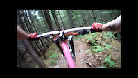
trail: Pedal Fed
10:10 |
113 |
Jan 7, 2025 , Kitimat

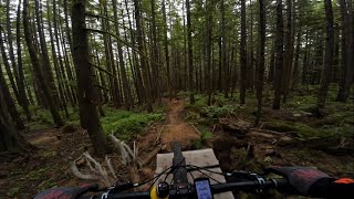
trail: Skeletor
10:10 |
173 |
Jan 7, 2025 , Kitimat

trail: Kissypants
10:10 |
127 |
Jan 7, 2025 , Kitimat
trail: Greenwood
10:10 |
72 |
Jan 7, 2025 , Kitimat

trail: Greenwood
10:10 |
115 |
Jan 7, 2025 , Kitimat
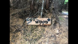
trail: Got Wood
4:50 |
144 |
Nov 20, 2024 , Kitimat
trail: Skeletor
3:32 |
485 |
Jun 23, 2011

trail: Greenwood
2:30 |
309 |
Jun 23, 2011
Recent Trail Reports
| status | trail | date | condition | info | user |
|---|---|---|---|---|---|
| Got Wood | Jun 15, 2026 @ 6:19pm (America/Metlakatla) Jun 15, 2026 | Wet | Aczor | ||
| Greenwood | Dec 31, 2025 @ 8:47am (America/Vancouver) Dec 31, 2025 | Snow Covered | Seanx100 MECA | ||
| Pedal Fed | Jul 30, 2025 @ 5:44pm Jul 30, 2025 | Ideal | Sydney7RQiok | ||
| Greenwood | Jul 9, 2022 @ 4:47pm Jul 9, 2022 | Variable | JennHji0vX | ||
| Kissypants | Mar 24, 2022 @ 8:56pm Mar 24, 2022 | Ideal | Erku | ||
| Skeletor | Mar 24, 2022 @ 8:55pm Mar 24, 2022 | Ideal | Erku | ||
| Dadook Connector | May 7, 2021 @ 10:01pm May 7, 2021 | Variable | AnthonyDem |
Activity Feed
| username | action | type | title | date |
|---|---|---|---|---|
| Aczor | add | report | activity #97085149 | Jun 15, 2026 @ 8:26pm Jun 15, 2026 |
| Seanx100 | add | report | activity #86388829 | Dec 31, 2025 @ 8:47am Dec 31, 2025 |
| Cameronbot9000 | vote | trail | activity #81319933 | Sep 28, 2025 @ 2:07pm Sep 28, 2025 |
| Seanx100 | ridden | trail | activity #80373259 | Sep 14, 2025 @ 3:42pm Sep 14, 2025 |
| Seanx100 | add | photo | activity #77315741 | Aug 3, 2025 @ 8:46am Aug 3, 2025 |
Recent Comments
| username | type | title | comment | date |
|---|---|---|---|---|
| trail | Super fun trail with some cool rock work and... | Jun 12, 2020 @ 11:22pm Jun 12, 2020 | ||
| trail | Super fun trail, great in dry and wet... | Jun 12, 2020 @ 11:08pm Jun 12, 2020 | ||
| trail | Dry, clean, good condition | Jul 21, 2019 @ 3:28pm Jul 21, 2019 |
Nearby Areas
| name | distance | ||||
|---|---|---|---|---|---|
| Haisla Hill | 2 | 2 | 1 | 1.3 km | |
| Popper | 1 | 3.4 km | |||
| Copper Mountain | 2 | 8 | 12 | 4 | 30.9 km |
| Terrace Mountain | 7 | 11 | 9 | 1 | 33.9 km |
Activity Type Stats
| activitytype | trails | distance | descent | descent distance | total vertical | rating | global rank | state rank | photos | reports | routes | ridelogs |
|---|---|---|---|---|---|---|---|---|---|---|---|---|
| Mountain Bike | 10 | 2 miles | 899 ft | 1 mile | 371 ft | #6,517 | #277 | 78 | 68 | 677 | ||
| E-Bike | 2 | 4,009 ft | 26 ft | 299 ft | 18 | 20 | ||||||
| Hike | 8 | 2 miles | 594 ft | 4,226 ft | 371 ft | #18,432 | #616 | 64 | 47 | |||
| Trail Running | 7 | 2 miles | 430 ft | 3,255 ft | 371 ft | #17,509 | #570 | 53 | 12 |
Frequently Asked Questions About Skeletor
▼
What are the highest rated mountain biking trails in Skeletor?
The highest rated mountain biking trails in Skeletor are:
- Old Skeletor (4.1/5)
- Got Wood (4.1/5)
- Kissypants (4.1/5)
- Skeletor (4/5)
- Greenwood (4/5)
▼
What is the best time of the year to ride in Skeletor?
Based on ride log data, the most popular months to ride in Skeletor are:
- July (16 activities)
- September (15 activities)
- May (14 activities)
▼
Where can I park to ride in Skeletor?
Check the Skeletor trail map for trailhead and parking information. Community members regularly update access and parking details for trails in the area.
▼
What is the longest trail in Skeletor?
The longest trail in Skeletor is Pedal Fed at 4,009 ft. View all trails sorted by distance.
- By raversth & contributors
- Admins: NBC, PGBRS, aleksa, MECA
- #10325 - 2,778 views
- skeletor activity log | embed map of Skeletor mountain bike trails |
Downloading of trail gps tracks in kml & gpx formats is enabled for Skeletor.
You must login to download files.