close
-
Layers w
- Weather Layers
- Pro
- Pro
- Pro
- Pro
- Pro
- Pro
- More Layers
- Pro
- Pro
- Pro
- Pro
-
Upgrade to

3D
Trail Conditions
- Unknown
- Snow Groomed
- Snow Packed
- Snow Covered
- Snow Cover Partial
- Freeze/thaw Cycle
- Icy
- Prevalent Mud
- Wet
- Variable
- Ideal
- Dry
- Very Dry
Trail Flow (Ridden Direction)
Trailforks scans users ridelogs to determine the most popular direction each trail is ridden. A good flowing trail network will have most trails flowing in a single direction according to their intension.
The colour categories are based on what percentage of riders are riding a trail in its intended direction.
The colour categories are based on what percentage of riders are riding a trail in its intended direction.
- > 96%
- > 90%
- > 80%
- > 70%
- > 50%
- < 50%
- bi-directional trail
- no data
Trail Last Ridden
Trailforks scans ridelogs to determine the last time a trail was ridden.
- < 2 days
- < 1 week
- < 2 weeks
- < 1 month
- < 6 months
- > 6 months
Trail Ridden Direction
The intended direction a trail should be ridden.
- Downhill Only
- Downhill Primary
- Both Directions
- Uphill Primary
- Uphill Only
- One Direction
Contribute Details
Colors indicate trail is missing specified detail.
- Description
- Photos
- Description & Photos
- Videos
Trail Popularity ?
Trailforks scans ridelogs to determine which trails are ridden the most in the last 9 months.
Trails are compared with nearby trails in the same city region with a possible 25 colour shades.
Think of this as a heatmap, more rides = more kinetic energy = warmer colors.
- most popular
- popular
- less popular
- not popular
ATV/ORV/OHV Filter
Max Vehicle Width
inches
US Cell Coverage
Legend

Radar Time
Activity Recordings
Trailforks uses anonymized public activity data.
?
Activity Recordings
Trailforks uses anonymized public activity data.
?
Personal Heatmap
▶
Activity Types
all
/
none
▶
Options
2
Date range
month
–
Winter Trails
Warning
A routing network for winter maps does not exist. Selecting trails using the winter trails layer has been disabled.
Missing Trails
Most Popular
Least Popular
Trails are colored based on popularity. The more popular a trail is, the more red. Less popular trails trend towards green.
Jump Magnitude Heatmap
Heatmap of where riders jump on trails. Zoom in to see individual jumps, click circles to view jump details.
BC Backroad Status
![map legend]()
Service Road Atlas is a free to use, community-driven service for viewing and creating reports on the numerous back-country service roads around B.C. and Alberta.

Slope Aspect
Direction the slope faces
Trails Deemphasized
Trails are shown in grey.
Only show trails with no bike usage.
Suggested Layers
Based on selected activity type
Save the current map location and zoom level as your default home location whenever this page is loaded.
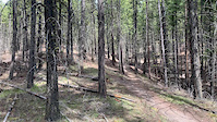
SaveSmith Creek is an area of West Kelowna with an ever expanding network of all mountain trails. Turn north on Elliot Road in downtown West Kelowna, follow this road out as it meanders up the hillside. Turn right onto Smith Creek Road and travel up to the gravel section continuing on until you reach a small gravel parking area on the left. The trail heads out from this lot and crosses the road into the main network within a few hundred meters. Follow the small trail and km markers up as you go. The ascent crosses the main downhill run all the way up so there are many opportunities to head back down. Keep your eyes and ears open for riders coming down
This loop is one of the few that offer a great meandering singletrack climb instead of a fire road ascent. The trail snakes its way up the mountain on smooth, flowing single-track with tight technical turns. Towards the top of the climb the trail gets steeper and a little more difficult to climb, but by this point you are nearly up. Once at the top you will be on a plateau looking over West Kelowna. The trails head off to your right from here so lower your saddle and drop in on one of many optional descents. This entire loop takes about two hours to ride and most likely a little longer for intermediate riders. One of the Central Okanagan’s best rides by far.
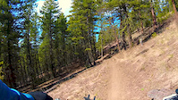
Smith Creek DescendingThis trail is extremely popular so you should have no problem running into a local to help with directions up or down specific routes. Trail maps for the area are available at all the local bike shops in Kelowna and West Kelowna. Just ask for the “Trails of the Westside” map.
This loop is one of the few that offer a great meandering singletrack climb instead of a fire road ascent. The trail snakes its way up the mountain on smooth, flowing single-track with tight technical turns. Towards the top of the climb the trail gets steeper and a little more difficult to climb, but by this point you are nearly up. Once at the top you will be on a plateau looking over West Kelowna. The trails head off to your right from here so lower your saddle and drop in on one of many optional descents. This entire loop takes about two hours to ride and most likely a little longer for intermediate riders. One of the Central Okanagan’s best rides by far.
Smith Creek DescendingThis trail is extremely popular so you should have no problem running into a local to help with directions up or down specific routes. Trail maps for the area are available at all the local bike shops in Kelowna and West Kelowna. Just ask for the “Trails of the Westside” map.
Primary Trail Type: All-Mountain & Downhill
Land Status: Crown Land
Land Manager: RSTBC
 google parking directions
 Region Supporters & Maintainers
![]()
Mountain Bikers of the Central OkanaganMaintainer
Activities Click to view
- Mountain Bike
26 trails
- E-Bike
22 trails
- Hike
23 trails
- Trail Running
23 trails
Region Details
- 2
- 5
- 10
- 9
Region Status
Open as of Jun 13, 2026Stats
- Avg Trail Rating
- Trails (view details)
- 27
- Trails Mountain Bike
- 26
- Trails E-Bike
- 22
- Trails Hike
- 23
- Trails Trail Running
- 23
- Total Distance
- 23 miles
- Total Descent
- 7,720 ft
- Total Vertical
- 1,899 ft
- Highest Trailhead
- 3,821 ft
- Reports
- 2,274
- Photos
- 485
- Ridden Counter
- 35,986
Popular Smith Creek Mountain Biking Trails
• 100 ★ 4.7 • 5 miles • 1,391 ft • 3,137 •
One Way ONLY! Trail starts at the kiosk end of the Main Smith Creek Parking Lot. Look for the signs. A beautiful string of meandering single track that winds its way up, catching all the different soil and terrain the area has. This...
• 100 ★ 4.7 • 2 miles • 29 ft • 3,058 •
is, by far, the most popular descent trail in the Smith Creek Trail Network. The trail begins at a flat clearing that is approximately 7.4km from the parking lot riding up The Holy Pail Climb trail. The Trail head is well marked and...
• 100 ★ 4.9 • 1,106 ft • 62 ft • 2,131 •
Switchback climb option to avoid some technical rocky bits on Holy Pail.
• 100 ★ 4.2 • 3,045 ft • 202 ft • 2,012 •
This is the climb that continues past . It takes about ten to fifteen minutes until you are at a Y- intersection where you can go right to climb up or left to Climb up Kid Dino Myt. Watch for oncoming traffic because this trail doubles...
• 100 ★ 4.7 • 1,516 ft • 105 ft • 1,529 •
Climb to Kid Dino Myt peak.
• 100 ★ 3.3 • 413 ft • 34 ft • 1,514 •
Popular green difficulty singletrack. This mountain bike primary trail and has a easy overall physical rating with a 34 ft green climb. Trail visibility is always easy to follow. On average it takes minutes to complete this trail.
• 100 ★ 4.5 • 4,016 ft • 0 ft • 1,415 •
Fear Of Missing Out. Do I ride the Gulley trail or this trail??? Which one??? was built as a Spring bypass for the Gulley trail but you're gonna like it so much - it may just become your new favorite trail. Fast and flowy with berms and...
Smith Creek Mountain Bike Routes
FITM Enduro 2022 Featured
★ 5.0 • 18 miles • 3,939 ft • 10 •
Hello and thank you for your support of the first Fire in the Mountains Charity Enduro organized by the...
4 miles • 1,239 ft • 2 • Loop •
The classic Smith Creek lap. Holy Pail to the top of and back to the parking lot!
7 miles • 1,385 ft • 7 • Loop •
For this Sovereign Cycle group ride a fast, flowing descent is the name of the game. Let's head down Smith...
5 miles • 1,235 ft • 14 •
Sovereign Group ride including the new trail, FOMO.
7 miles • 1,404 ft • 4 •
This is likely the most ridden loop at Smith Creek. If you want to experience the classic it's the way to...
9 miles • 2,021 ft • 10 •
Okanagan SW Smith Creek Classic Okanagan South West Relive Your Rides For other ride suggestions for this...
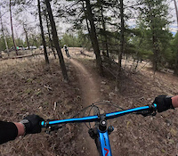
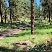
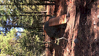
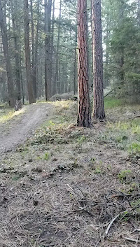
Photos of Smith Creek Mountain Bike
Videos of Smith Creek Mountain Bike
trail: Feel The Love
0:16 |
23 |
Mar 29, 2026
trail: Smith Creek Jump Line
0:09 |
|
Mar 2, 2023

trail: Smith Creek Jump Line
0:59 |
366 |
Nov 3, 2022
trail: Kid DinoMyt Descent
0:08 |
|
Oct 13, 2020
trail: Feel The Love
0:25 |
146 |
Jun 12, 2020
trail: Smith Creek Jump Line
0:24 |
632 |
Apr 13, 2020
trail: Santa's Revenge
2:40 |
251 |
Apr 12, 2020
trail: Feel The Love
0:12 |
5687 |
Oct 7, 2019
Recent Trail Reports
| status | trail | date | condition | info | user |
|---|---|---|---|---|---|
| Dear Santa | Jun 13, 2026 @ 5:14pm (America/Vancouver) Jun 13, 2026 | Unknown | Spyrus MTBCOW | ||
| Kid DinoMyt Descent | Jun 11, 2026 @ 4:00pm (America/Creston) Jun 11, 2026 | Ideal | RobbieBGood | ||
| Holy Pail Up (Climb to Kid Dino Myt) | Jun 11, 2026 @ 4:00pm (America/Creston) Jun 11, 2026 | Ideal | RobbieBGood | ||
| Holy Pail Up (To SoulTrain/ Kid Dino Myt) | Jun 11, 2026 @ 4:00pm (America/Creston) Jun 11, 2026 | Ideal | RobbieBGood | ||
| Holy Pail Switchback Option | Jun 11, 2026 @ 4:00pm (America/Creston) Jun 11, 2026 | Ideal | RobbieBGood | ||
| Holy Pail Easy Option | Jun 11, 2026 @ 4:00pm (America/Creston) Jun 11, 2026 | Ideal | RobbieBGood | ||
| First, Bottom, Connector to Dear Santa | Jun 11, 2026 @ 4:00pm (America/Creston) Jun 11, 2026 | Ideal | RobbieBGood | ||
| Holy Pail Up (Climb) | Jun 11, 2026 @ 4:00pm (America/Creston) Jun 11, 2026 | Ideal | RobbieBGood | ||
| Flume Trail | Jun 11, 2026 @ 4:00pm (America/Creston) Jun 11, 2026 | Ideal | RobbieBGood | ||
| FOMO | May 23, 2026 @ 12:53pm (America/Vancouver) May 23, 2026 | Dry | roberm MTBCOW |
Activity Feed
| username | action | type | title | date |
|---|---|---|---|---|
| CherylTQE1rL | wishlist | trail | activity #97442114 and 1 more | Jun 20, 2026 @ 4:38pm 9 hours |
| CashMoneyMillz | wishlist | trail | activity #97441374 | Jun 20, 2026 @ 4:25pm 10 hours |
| dfrizzell | wishlist | route | activity #97398438 | Jun 20, 2026 @ 8:28am 18 hours |
| Noobfersure | wishlist | route | activity #97038975 | Jun 15, 2026 @ 7:11am Jun 15, 2026 |
| bigbluesky | ridden | trail | activity #97001441 | Jun 14, 2026 @ 1:38pm Jun 14, 2026 |
Recent Comments
| username | type | title | comment | date |
|---|---|---|---|---|
| report | Yay!!! | Jan 18, 2026 @ 1:51pm Jan 18, 2026 | ||
| report | Where is the tree down ? Can you post a map... | Nov 12, 2025 @ 2:54pm Nov 12, 2025 | ||
| trail | Super fun trail. Little jumps and cool gully... | Oct 10, 2025 @ 10:30am Oct 10, 2025 | ||
| trail | Easiest climb trail in BC, even easier than... | Aug 20, 2025 @ 7:14pm Aug 20, 2025 | ||
| trail | One of the best blue trails anywhere. You'll... | Aug 20, 2025 @ 7:11pm Aug 20, 2025 |
Nearby Areas
| name | distance | ||||
|---|---|---|---|---|---|
| Powers Creek | 5 | 4 | 16 | 1 | 1.7 km |
| Goats Peak Regional Park | 1 | 3.9 km | |||
| Rose Valley | 13 | 38 | 9 | 3 | 4.8 km |
| Kalamoir Regional Park | 4 | 5.4 km | |||
| Bear Creek Provincial Park | 7.7 km |
Local Badges
-

Completionist1 awarded
Activity Type Stats
| activitytype | trails | distance | descent | descent distance | total vertical | rating | global rank | state rank | photos | reports | routes | ridelogs |
|---|---|---|---|---|---|---|---|---|---|---|---|---|
| Mountain Bike | 26 | 22 miles | 7,480 ft | 13 miles | 1,900 ft | #431 | #49 | 458 | 2,265 | 26 | 29,225 | |
| E-Bike | 22 | 22 miles | 7,438 ft | 13 miles | 1,900 ft | #913 | #44 | 22 | 1,969 | 4 | 1,772 | |
| Hike | 23 | 19 miles | 5,801 ft | 10 miles | 1,900 ft | #4,705 | #197 | 2,171 | 734 | |||
| Trail Running | 23 | 19 miles | 5,801 ft | 10 miles | 1,900 ft | #3,884 | #122 | 3 | 2,171 | 377 |
Frequently Asked Questions About Smith Creek
▼
What are the highest rated mountain biking trails in Smith Creek?
The highest rated mountain biking trails in Smith Creek are:
- Feel The Love (4.6/5)
- Holy Pail Up (Climb) (4.6/5)
- Holy Pail Switchback Option (4.4/5)
- FOMO (4.3/5)
- Holy Pail Up (Climb to Kid Dino Myt) (4.3/5)
▼
What is the best time of the year to ride in Smith Creek?
Based on ride log data, the most popular months to ride in Smith Creek are:
- July (534 activities)
- June (441 activities)
- May (409 activities)
▼
Where can I park to ride in Smith Creek?
There are 3 parking locations listed in Smith Creek. The most popular parking spots are: View all parking and trailhead locations on the map to plan your visit.
▼
What is the longest trail in Smith Creek?
The longest trail in Smith Creek is Holy Pail Up (Climb) at 4.5 miles. View all trails sorted by distance.
Activities
Trails
Points of Interest
- By brenthillier
 NSMBA TRAILFORKS & contributors
 - Admins: MTBCOW, MTBco
- #3590 - 98,812 views
- smith creek activity log | embed map of Smith Creek mountain bike trails | smith creek mountain biking points of interest polygons
Downloading of trail gps tracks in kml & gpx formats is enabled for Smith Creek.
You must login to download files.