close
-
Layers w
- Weather Layers
- Pro
- Pro
- Pro
- Pro
- Pro
- Pro
- More Layers
- Pro
- Pro
- Pro
- Pro
-
Upgrade to

3D
Trail Conditions
- Unknown
- Snow Groomed
- Snow Packed
- Snow Covered
- Snow Cover Partial
- Freeze/thaw Cycle
- Icy
- Prevalent Mud
- Wet
- Variable
- Ideal
- Dry
- Very Dry
Trail Flow (Ridden Direction)
Trailforks scans users ridelogs to determine the most popular direction each trail is ridden. A good flowing trail network will have most trails flowing in a single direction according to their intension.
The colour categories are based on what percentage of riders are riding a trail in its intended direction.
The colour categories are based on what percentage of riders are riding a trail in its intended direction.
- > 96%
- > 90%
- > 80%
- > 70%
- > 50%
- < 50%
- bi-directional trail
- no data
Trail Last Ridden
Trailforks scans ridelogs to determine the last time a trail was ridden.
- < 2 days
- < 1 week
- < 2 weeks
- < 1 month
- < 6 months
- > 6 months
Trail Ridden Direction
The intended direction a trail should be ridden.
- Downhill Only
- Downhill Primary
- Both Directions
- Uphill Primary
- Uphill Only
- One Direction
Contribute Details
Colors indicate trail is missing specified detail.
- Description
- Photos
- Description & Photos
- Videos
Trail Popularity ?
Trailforks scans ridelogs to determine which trails are ridden the most in the last 9 months.
Trails are compared with nearby trails in the same city region with a possible 25 colour shades.
Think of this as a heatmap, more rides = more kinetic energy = warmer colors.
- most popular
- popular
- less popular
- not popular
ATV/ORV/OHV Filter
Max Vehicle Width
inches
US Cell Coverage
Legend

Radar Time
Activity Recordings
Trailforks uses anonymized public activity data.
?
Activity Recordings
Trailforks uses anonymized public activity data.
?
Personal Heatmap
▶
Activity Types
all
/
none
▶
Options
2
Date range
month
–
Winter Trails
Warning
A routing network for winter maps does not exist. Selecting trails using the winter trails layer has been disabled.
Missing Trails
Most Popular
Least Popular
Trails are colored based on popularity. The more popular a trail is, the more red. Less popular trails trend towards green.
Jump Magnitude Heatmap
Heatmap of where riders jump on trails. Zoom in to see individual jumps, click circles to view jump details.
BC Backroad Status
![map legend]()
Service Road Atlas is a free to use, community-driven service for viewing and creating reports on the numerous back-country service roads around B.C. and Alberta.

Slope Aspect
Direction the slope faces
Trails Deemphasized
Trails are shown in grey.
Only show trails with no bike usage.
Suggested Layers
Based on selected activity type
Save the current map location and zoom level as your default home location whenever this page is loaded.
Save
No description for Snohomish has been added yet!
Login or register to submit one.
Activities Click to view
- Mountain Bike
50 trails
- Gravel Bike
0 trails
- Adaptive Bike
0 trails
- Winter Fat Bike
0 trails
- Horse
36 trails
- Hike
72 trails
- Trail Running
72 trails
Region Details
- 7
- 29
- 12
- 1
Region Status
Open as of Jun 11, 2026Local Trail Association
Stats
- Avg Trail Rating
- Trails (view details)
- 78
- Trails Mountain Bike
- 51
- Trails E-Bike
- 2
- Trails Horse
- 37
- Trails Hike
- 72
- Trails Trail Running
- 72
- Total Distance
- 31 miles
- Total Descent
- 5,608 ft
- Total Vertical
- 737 ft
- Highest Trailhead
- 760 ft
- Reports
- 2,700
- Photos
- 283
- Ridden Counter
- 18,990
Sub Regions
-
Lord Hill Regional Park
- 27
- 12
- 1
Popular Snohomish Mountain Biking Trails
• 90 ★ 4.5 • 2,087 ft • 0 ft • 1,103 •
Fun flowing, downhill slanting trail with occasional roots, smooth singletrack and good corners. Trail starts with slight XC climb then descends down to the access trail. Near the bottom there's a larger drop off the side of the that...
• 90 ★ 4.4 • 1,565 ft • 2 ft • 1,042 •
This is a great flow trail for all rider levels that starts with a short rock garden which is the hardest part of the trail. Once past that, it becomes a mostly smooth and flowy trail with bermed twists and turns. Riders can extend...
• 85 ★ 4.4 • 1,867 ft • 36 ft • 999 •
Off the pipe line, this trail starts slightly up hill, going past the new gap jump on . It drops into a few berms (trust those tires!) and zigs and zags down and across the hill. A new log ride and an option for another jump before the...
• 100 ★ 4.5 • 1,010 ft • 0 ft • 920 •
Flow trail with some berms and rollable jumps which branches off of . The trail connects with where you need to go a little uphill before finishing the descent.
• 80 ★ 3.0 • 1,165 ft • 24 ft • 815 •
Overall nice and easy XC trail. This trail has some tighter turns and some technical parts. It can be ridden it both directions but it is mostly ridden in the direction marked.
• 85 ★ 4.7 • 1,306 ft • 0 ft • 801 •
One of the best downhill trails at LH. Wonderfully flowing and steep single track. Trust your line on the berms and carry your speed! Entrance starts on top of the big rock garden, sharing the start to Golden Eye. Starting on top of the...
• 90 ★ 4.5 • 456 ft • 0 ft • 776 •
New DH trail off of SpringBoard. Gotta hit the log drop, no brakes for the step up jump, a little jump and finally a nice berm into a small gap jump.
• 95 ★ 2.7 • 1,929 ft • 90 ft • 774 •
Mostly used as climbing access to downhill trails. This trail is a really wide singletrack with a mellow grade given it was partially built on top of an old DNR road.
Snohomish Mountain Bike Routes
10 miles • 1,380 ft • 19 •
This route combines both downhill and XC trails to create the 3 longest downhill runs in the park. Expect...
★ 3.0 • 8 miles • 1,392 ft • 20 •
This takes the easiest climb from the park's south entrance to access the core mountain bike trails. The...
8 miles • 1,033 ft • 20 •
Focusing on downhill trails. Upper and , Meat Cutter, Golden Eye, , .
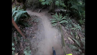
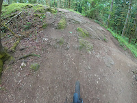
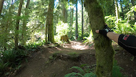
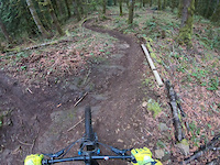
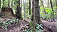
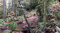
Photos of Snohomish Mountain Bike
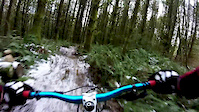
Videos of Snohomish Mountain Bike
trail: Meet Cutter
3:04 |
104 |
Dec 9, 2024
2:12 |
150 |
May 29, 2023
trail: Upper Springboard
0:19 |
150 |
May 28, 2023
trail: Goldeneye
0:42 |
154 |
Apr 9, 2023
trail: Diving Board
0:11 |
|
May 1, 2021
trail: Diving Board
0:07 |
|
Nov 11, 2019

trail: Upper Springboard
0:37 |
549 |
Feb 23, 2018
trail: Ewe Tube
0:13 |
204 |
Feb 23, 2018
Recent Trail Reports
| status | trail | date | condition | info | user |
|---|---|---|---|---|---|
| Quarry Trail | Jun 11, 2026 @ 7:54pm (America/Los_Angeles) Jun 11, 2026 | Variable | jordanlacroix SVS | ||
| Quarry Loop Trail | Jun 11, 2026 @ 7:54pm (America/Los_Angeles) Jun 11, 2026 | Variable | jordanlacroix SVS | ||
| Ewe Tube | Jun 11, 2026 @ 7:54pm (America/Los_Angeles) Jun 11, 2026 | Variable | jordanlacroix SVS | ||
| River Cutoff Trail | Jun 6, 2026 @ 3:34pm (America/Los_Angeles) Jun 6, 2026 | Variable | jordanlacroix SVS | ||
| Upper Springboard | Jun 5, 2026 @ 8:00pm (America/Los_Angeles) Jun 5, 2026 | Ideal | jordanlacroix SVS | ||
| The Sink | Jun 5, 2026 @ 8:00pm (America/Los_Angeles) Jun 5, 2026 | Ideal | jordanlacroix SVS | ||
| Meet Cutter | Jun 2, 2026 @ 8:25am (America/Vancouver) Jun 2, 2026 | Ideal | kb7rsk | ||
| Liquid Bread | Jun 2, 2026 @ 8:25am (America/Vancouver) Jun 2, 2026 | Ideal | kb7rsk | ||
| Upper Lot Entrance Trail | Jun 2, 2026 @ 8:25am (America/Vancouver) Jun 2, 2026 | Ideal | kb7rsk | ||
| West View Trail | Jun 2, 2026 @ 8:25am (America/Vancouver) Jun 2, 2026 | Ideal | kb7rsk |
Activity Feed
| username | action | type | title | date |
|---|---|---|---|---|
| jordanlacroix | add | report | activity #96780418 and 2 more | Jun 11, 2026 @ 7:54pm Jun 11, 2026 |
| LisajIrHRD | wishlist | route | activity #96470527 | Jun 7, 2026 @ 9:30am Jun 7, 2026 |
| conhoward | wishlist | route | activity #96466955 | Jun 7, 2026 @ 8:55am Jun 7, 2026 |
| jordanlacroix | add | report | activity #96411094 and 2 more | Jun 6, 2026 @ 3:34pm Jun 6, 2026 |
| jordanlacroix | add | report | activity #96339334 and 2 more | Jun 5, 2026 @ 8:00pm Jun 5, 2026 |
Recent Comments
| username | type | title | comment | date |
|---|---|---|---|---|
| trail | The new reroute is very fun and flowy. It... | May 10, 2026 @ 8:59pm May 10, 2026 | ||
| report | Heading there now from silver lake! Thx | Jan 13, 2026 @ 9:24am Jan 13, 2026 | ||
| report | At the time the trail was closed, it was... | Nov 12, 2025 @ 10:39am Nov 12, 2025 | ||
| report | I mean i did it for the first time a few days... | Nov 12, 2025 @ 9:21am Nov 12, 2025 | ||
| report | I think Easy 8 is still open, but like you... | Nov 12, 2025 @ 7:47am Nov 12, 2025 |
Local Badges
-

10 Blue Trails327 awarded -

Epic Ride Climb 2k4 awarded -

Climbing 10k Badge37 awarded -

Climbing 100k Badge1 awarded -

Completionist1 awarded -

Epic Ride Descent 2k4 awarded
Activity Type Stats
| activitytype | trails | distance | descent | descent distance | total vertical | rating | global rank | state rank | photos | reports | routes | ridelogs |
|---|---|---|---|---|---|---|---|---|---|---|---|---|
| Mountain Bike | 50 | 20 miles | 3,579 ft | 10 miles | 735 ft | #1,173 | #452 | 263 | 2,703 | 3 | 10,373 | |
| E-Bike | 2 | 2 miles | 20 ft | 3,100 ft | 26 ft | 1,224 | 598 | |||||
| Horse | 36 | 17 miles | 2,552 ft | 8 miles | 646 ft | #1,658 | #950 | 1,260 | 3 | |||
| Hike | 72 | 30 miles | 5,030 ft | 13 miles | 738 ft | #942 | #428 | 15 | 2,784 | 649 | ||
| Trail Running | 72 | 30 miles | 5,030 ft | 13 miles | 738 ft | #4,418 | #1,353 | 5 | 2,785 | 738 |
Frequently Asked Questions About Snohomish
▼
What are the best places to ride in Snohomish?
Snohomish has 1 areas to explore for mountain biking. The top rated areas are:
▼
What are the highest rated mountain biking trails in Snohomish?
The highest rated mountain biking trails in Snohomish are:
- Wishbone (4.5/5)
- Ewe Tube (4.4/5)
- Upper Springboard (4.3/5)
- Third Eye (4.3/5)
- Goldeneye (4.2/5)
▼
What is the best time of the year to ride in Snohomish?
Based on ride log data, the most popular months to ride in Snohomish are:
- July (266 activities)
- August (214 activities)
- June (197 activities)
▼
Where can I park to ride in Snohomish?
There are 3 parking locations listed in Snohomish. The most popular parking spots are: View all parking and trailhead locations on the map to plan your visit.
Activities
Trails
- By boxxerace
 TRAILFORKS EMBA-BOD & contributors
 - Admins: EMBA-C2S, EMBA-C2S
- #15588 - 3,824 views
- snohomish activity log | embed map of Snohomish mountain bike trails | snohomish mountain biking points of interest
Downloading of trail gps tracks in kml & gpx formats is enabled for Snohomish.
You must login to download files.