close
-
Layers w
- Weather Layers
- Pro
- Pro
- Pro
- Pro
- Pro
- Pro
- More Layers
- Pro
- Pro
- Pro
- Pro
-
Upgrade to

3D
Trail Conditions
- Unknown
- Snow Groomed
- Snow Packed
- Snow Covered
- Snow Cover Partial
- Freeze/thaw Cycle
- Icy
- Prevalent Mud
- Wet
- Variable
- Ideal
- Dry
- Very Dry
Trail Flow (Ridden Direction)
Trailforks scans users ridelogs to determine the most popular direction each trail is ridden. A good flowing trail network will have most trails flowing in a single direction according to their intension.
The colour categories are based on what percentage of riders are riding a trail in its intended direction.
The colour categories are based on what percentage of riders are riding a trail in its intended direction.
- > 96%
- > 90%
- > 80%
- > 70%
- > 50%
- < 50%
- bi-directional trail
- no data
Trail Last Ridden
Trailforks scans ridelogs to determine the last time a trail was ridden.
- < 2 days
- < 1 week
- < 2 weeks
- < 1 month
- < 6 months
- > 6 months
Trail Ridden Direction
The intended direction a trail should be ridden.
- Downhill Only
- Downhill Primary
- Both Directions
- Uphill Primary
- Uphill Only
- One Direction
Contribute Details
Colors indicate trail is missing specified detail.
- Description
- Photos
- Description & Photos
- Videos
Trail Popularity ?
Trailforks scans ridelogs to determine which trails are ridden the most in the last 9 months.
Trails are compared with nearby trails in the same city region with a possible 25 colour shades.
Think of this as a heatmap, more rides = more kinetic energy = warmer colors.
- most popular
- popular
- less popular
- not popular
ATV/ORV/OHV Filter
Max Vehicle Width
inches
US Cell Coverage
Legend

Radar Time
Activity Recordings
Trailforks uses anonymized public activity data.
?
Activity Recordings
Trailforks uses anonymized public activity data.
?
Personal Heatmap
▶
Activity Types
all
/
none
▶
Options
2
Date range
month
–
Winter Trails
Warning
A routing network for winter maps does not exist. Selecting trails using the winter trails layer has been disabled.
Missing Trails
Most Popular
Least Popular
Trails are colored based on popularity. The more popular a trail is, the more red. Less popular trails trend towards green.
Jump Magnitude Heatmap
Heatmap of where riders jump on trails. Zoom in to see individual jumps, click circles to view jump details.
BC Backroad Status
![map legend]()
Service Road Atlas is a free to use, community-driven service for viewing and creating reports on the numerous back-country service roads around B.C. and Alberta.

Slope Aspect
Direction the slope faces
Trails Deemphasized
Trails are shown in grey.
Only show trails with no bike usage.
Suggested Layers
Based on selected activity type
Save the current map location and zoom level as your default home location whenever this page is loaded.
Save
No description for Snoqualmie has been added yet!
Login or register to submit one.
Activities Click to view
- Mountain Bike
101 trails
- E-Bike
14 trails
- Gravel Bike
19 trails
- Adaptive Bike
21 trails
- Winter Fat Bike
2 trails
- Horse
18 trails
- Hike
105 trails
- Trail Running
103 trails
- Snowmobile
1 trails
- Snowshoe
2 trails
- Downhill Ski
0 trails
- Backcountry Ski
0 trails
- Nordic Ski
2 trails
Region Details
- 49
- 2
- 28
- 13
- 5
- 4
Region Status
Open as of Jun 16, 2026Local Trail Association
Stats
- Avg Trail Rating
- Trails (view details)
- 124
- Trails Mountain Bike
- 101
- Trails E-Bike
- 14
- Trails Gravel Bike
- 19
- Trails Adaptive Bike
- 21
- Trails Winter Fat Bike
- 2
- Trails Horse
- 18
- Trails Hike
- 105
- Trails Trail Running
- 103
- Trails Snowmobile
- 1
- Trails Snowshoe
- 2
- Trails Nordic Ski
- 2
- Total Distance
- 221 miles
- Total Descent
- 24,191 ft
- Total Vertical
- 4,847 ft
- Highest Trailhead
- 4,969 ft
- Reports
- 3,873
- Photos
- 815
- Ridden Counter
- 94,857
Articles
Race Report: Sturdy Dirty Enduro 2025 - Perfect Trails & Rad Vibes
Aug 7, 2025 from pinkbike.com
The enduro race with big party energy, even bigger community vibes, and some truly unforgettable trail-side antics.

Race Report & Photos: Sturdy Dirty Enduro at Raging River
Jul 24, 2023 from pinkbike.com
300 women took to the trails at Raging River State Forest for the all-women’s mountain bike race.
Sub Regions
-
Middle Fork Snoqualmie River
- 3
- 2
-
Raging River State Forest
- 1
- 1
-
Snoqualmie Ridge
- 6
-
Snoqualmine State Forest
- 4
- 2
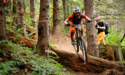
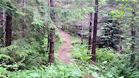
Popular Snoqualmie Mountain Biking Trails
• 100 ★ 4.7 • 3,104 ft • 3 ft • 6,265 •
is a great fast rolling downhill only trail, short but fun, flow not tech, can be ridden on a 24" bike for those that are adventurous! Access from , the , or .
• 100 ★ 4.7 • 2,740 ft • 0 ft • 6,247 •
[/FONT] A super fun, descending mountain bike only trail. Offer your thanks for this amazing trail by first, finally getting around to joining Evergreen Mountain Bike Alliance or getting current on your dues! Second, donate $20, or $100...
• 100 ★ 4.6 • 2,100 ft • 0 ft • 6,066 •
[/FONT] This intermediate descending trail has been completely rebuilt with bermed turns, small jumps and some technical fun. This is a family friendly trail designed to elevate riders' skill level. Special thanks: - Chris Lynch for...
• 100 ★ 4.5 • 3 miles • 995 ft • 6,037 •
is a single-direction, climbing only trail to access the Trail, as well as the descending only Poppin' Tops & Flow State trails.
• 100 ★ 4.7 • 2,365 ft • 21 ft • 5,071 •
[/FONT] An descending only trail for advanced riders only. This trail is much more challenging than lower Poppin' Tops & Flow State Trails. The progression is intentional, allowing riders to literally and figuratively "work their...
• 100 ★ 4.7 • 627 ft • 0 ft • 4,599 •
Connector Trail that gives riders access to Lower Poppin' Tops from climbing trail.
• 95 ★ 0.0 • 928 ft • 0 ft • 3,903 •
Short connecting trail where , Rattlesnake Lake Trail and the top of Pop-N-tops begins.
• 95 ★ 4.5 • 335 ft • 11 ft • 3,796 •
A multi-use connecting trail intended for mountain bikers and other users.
Snoqualmie Mountain Bike Routes
★ 3.8 • 5 miles • 1,013 ft • 12 • Loop •
Just got off work and only have an hour to ride? Are you an intermediate level rider or better looking for...
★ 4.4 • 19 miles • 3,821 ft • 38 • Loop •
The full Raging River Lollipop climbing and , descending , Climbing back out , then descending to Poppin...
★ 5.0 • 10 miles • 1,864 ft • 6 • Loop •
TL;DR;: It's , but skips the last 300 vertical feet. This means you need to stop after the fifth segment,...
★ 4.0 • 13 miles • 2,810 ft • 32 •
Raging River loop to Ridge line, then down back through Canyon Creek downhill and Poppin Tops lower - to...
3 miles • 639 ft • 3 • Loop •
2nd easiest loop at Raging River to hit both Upper (blue) and Lower (green) Flow State.. Climb to the 2nd...
Photos of Snoqualmie Mountain Bike
Videos of Snoqualmie Mountain Bike

0:43 |
148 |
Oct 7, 2023

trail: Raging Ridge
0:08 |
216 |
Aug 16, 2022
trail: PT (Middle)
0:09 |
217 |
Jul 24, 2022

trail: PT (Middle)
0:09 |
|
Jul 24, 2022

trail: Fisher Creek Trail
0:33 |
134 |
Jun 16, 2021

trail: Canyon Creek DH
11:04 |
194 |
Apr 14, 2021

2:38 |
99 |
Nov 20, 2020

0:57 |
|
Nov 20, 2020
Current Trail Warnings
| status | trail | date | condition | user | info |
|---|---|---|---|---|---|
| CCC Road | Jun 1, 2026 @ 2:43pm (America/Los_Angeles) Jun 1, 2026 | Variable | Cassbro | Overgrown vegetation |
Recent Trail Reports
Activity Feed
| username | action | type | title | date |
|---|---|---|---|---|
| nick1983 | wishlist | route | activity #97285705 | Jun 18, 2026 @ 5:31pm 13 hours |
| 5NRiEl | wishlist | region | activity #97176168 | Jun 17, 2026 @ 5:32am 2 days |
| Frosty43 | wishlist | region | activity #97155041 | Jun 16, 2026 @ 6:49pm 2 days |
| Awkragt | add | report | activity #97111503 | Jun 16, 2026 @ 8:12am 3 days |
| jillybeann | add | report | activity #97067587 and 6 more | Jun 15, 2026 @ 3:02pm Jun 15, 2026 |
Recent Comments
| username | type | title | comment | date |
|---|---|---|---|---|
| report | Forgot to add, ideal conditions | Jun 14, 2026 @ 5:27pm Jun 14, 2026 | ||
| trail | Ended up being much more adventurous than... | Jun 12, 2026 @ 1:09pm Jun 12, 2026 | ||
| report | Bro, that is so weird I was thinking the exact... | Jun 5, 2026 @ 7:13am Jun 5, 2026 | ||
| report | Me f qqqq’nzmbqq! M m y myq ‘ebmhJonynhshs... | Jun 4, 2026 @ 7:24pm Jun 4, 2026 | ||
| trail | The top third is cool rooty tech through the... | May 31, 2026 @ 11:29pm May 31, 2026 |
Local Badges
-

Epic Ride Climb 2k134 awarded -

Climbing 10k Badge757 awarded -

Climbing 100k Badge20 awarded -

Epic Ride Descent 2k143 awarded -

Descent 10k Badge773 awarded -

Descent 100k Badge22 awarded
Bike & Skill Parks
| name | type | city | rating |
|---|---|---|---|
| Fisher Creek Bike Park | skill park | Snoqualmie |
Upcoming Local Events
Activity Type Stats
| activitytype | trails | distance | descent | descent distance | total vertical | rating | global rank | state rank | photos | reports | routes | ridelogs |
|---|---|---|---|---|---|---|---|---|---|---|---|---|
| Mountain Bike | 101 | 184 miles | 20,364 ft | 64 miles | 4,731 ft | #168 | #64 | 795 | 3,869 | 52 | 76,512 | |
| E-Bike | 14 | 25 miles | 1,142 ft | 7 miles | 4,731 ft | #2,997 | #1,114 | 6 | 2,035 | 4 | 6,717 | |
| Gravel Bike | 19 | 34 miles | 1,949 ft | 7 miles | 2,877 ft | #304 | #919 | 271 | 130 | |||
| Adaptive Bike | 21 | 38 miles | 2,090 ft | 8 miles | 2,877 ft | #275 | #1,598 | 253 | 2 | 6 | ||
| Winter Fat Bike | 2 | 4 miles | 203 ft | 3,678 ft | 1,745 ft | #263 | #1,045 | 90 | 2 | |||
| Horse | 18 | 75 miles | 7,349 ft | 29 miles | 3,901 ft | #790 | #579 | 415 | 7 | |||
| Hike | 105 | 203 miles | 18,714 ft | 66 miles | 4,846 ft | #358 | #171 | 11 | 2,903 | 1 | 1,281 | |
| Trail Running | 103 | 201 miles | 18,701 ft | 65 miles | 4,846 ft | #731 | #274 | 2,902 | 1,571 | |||
| Snowmobile | 1 | 1,391 ft | 36 ft | #232 | #108 | 2 | 2 | |||||
| Snowshoe | 2 | 1 mile | 3 ft | 1,552 ft | 246 ft | #1,032 | #511 | 4 | 11 | |||
| Nordic Ski | 2 | 1 mile | 3 ft | 1,552 ft | 246 ft | #1,147 | #506 | 4 | 2 | 17 |
Frequently Asked Questions About Snoqualmie
▼
What are the best places to ride in Snoqualmie?
Snoqualmie has 7 areas to explore for mountain biking. The top rated areas are:
▼
What are the highest rated mountain biking trails in Snoqualmie?
The highest rated mountain biking trails in Snoqualmie are:
- Reverence (4.7/5)
- Flow State Lower (MOUNTAIN BIKING ONLY) (4.6/5)
- Poppin' Tops Upper (MOUNTAIN BIKES ONLY) (4.6/5)
- Flow State Upper (MOUNTAIN BIKING ONLY) (4.6/5)
- Canyon Creek DH (4.5/5)
▼
What is the best time of the year to ride in Snoqualmie?
Based on ride log data, the most popular months to ride in Snoqualmie are:
- July (1,284 activities)
- August (998 activities)
- June (895 activities)
▼
Where can I park to ride in Snoqualmie?
There are 20 parking locations listed in Snoqualmie. The most popular parking spots are:
- Parking (Discover Pass req.)
- Tiger Mountain Parking - Lower Lot
- Parking
- Parking
- Bessemer Mountain Trailhead
Activities
Trails
Points of Interest
- By jebike
 & contributors
 - Admins: EMBA-C2S, EMBA-C2S
- #5476 - 22,359 views
- snoqualmie activity log | embed map of Snoqualmie mountain bike trails | snoqualmie mountain biking points of interest polygons
Downloading of trail gps tracks in kml & gpx formats is enabled for Snoqualmie.
You must login to download files.