close
-
Layers w
- Weather Layers
- Pro
- Pro
- Pro
- Pro
- Pro
- Pro
- More Layers
- Pro
- Pro
- Pro
- Pro
-
Upgrade to

3D
Trail Conditions
- Unknown
- Snow Groomed
- Snow Packed
- Snow Covered
- Snow Cover Partial
- Freeze/thaw Cycle
- Icy
- Prevalent Mud
- Wet
- Variable
- Ideal
- Dry
- Very Dry
Trail Flow (Ridden Direction)
Trailforks scans users ridelogs to determine the most popular direction each trail is ridden. A good flowing trail network will have most trails flowing in a single direction according to their intension.
The colour categories are based on what percentage of riders are riding a trail in its intended direction.
The colour categories are based on what percentage of riders are riding a trail in its intended direction.
- > 96%
- > 90%
- > 80%
- > 70%
- > 50%
- < 50%
- bi-directional trail
- no data
Trail Last Ridden
Trailforks scans ridelogs to determine the last time a trail was ridden.
- < 2 days
- < 1 week
- < 2 weeks
- < 1 month
- < 6 months
- > 6 months
Trail Ridden Direction
The intended direction a trail should be ridden.
- Downhill Only
- Downhill Primary
- Both Directions
- Uphill Primary
- Uphill Only
- One Direction
Contribute Details
Colors indicate trail is missing specified detail.
- Description
- Photos
- Description & Photos
- Videos
Trail Popularity ?
Trailforks scans ridelogs to determine which trails are ridden the most in the last 9 months.
Trails are compared with nearby trails in the same city region with a possible 25 colour shades.
Think of this as a heatmap, more rides = more kinetic energy = warmer colors.
- most popular
- popular
- less popular
- not popular
ATV/ORV/OHV Filter
Max Vehicle Width
inches
US Cell Coverage
Legend

Radar Time
Activity Recordings
Trailforks uses anonymized public activity data.
?
Activity Recordings
Trailforks uses anonymized public activity data.
?
Personal Heatmap
▶
Activity Types
all
/
none
▶
Options
2
Date range
month
–
Winter Trails
Warning
A routing network for winter maps does not exist. Selecting trails using the winter trails layer has been disabled.
Missing Trails
Most Popular
Least Popular
Trails are colored based on popularity. The more popular a trail is, the more red. Less popular trails trend towards green.
Jump Magnitude Heatmap
Heatmap of where riders jump on trails. Zoom in to see individual jumps, click circles to view jump details.
BC Backroad Status
![map legend]()
Service Road Atlas is a free to use, community-driven service for viewing and creating reports on the numerous back-country service roads around B.C. and Alberta.

Slope Aspect
Direction the slope faces
Trails Deemphasized
Trails are shown in grey.
Only show trails with no bike usage.
Suggested Layers
Based on selected activity type
Save the current map location and zoom level as your default home location whenever this page is loaded.
SavePopular Trail Networks
view all areas »
No description for Sondrio has been added yet!
Login or register to submit one.
This region uses the Uk/Euro style trail grading system.
Activities Click to view
- Mountain Bike
765 trails
- E-Bike
494 trails
- Horse
29 trails
- Hike
699 trails
- Trail Running
695 trails
- Snowmobile
2 trails
- Snowshoe
18 trails
- Downhill Ski
150 trails
- Backcountry Ski
9 trails
- Nordic Ski
8 trails
Stats
- Avg Trail Rating
- Trails (view details)
- 745
- Trails Mountain Bike
- 766
- Trails E-Bike
- 494
- Trails Gravel Bike
- 1
- Trails Adaptive Bike
- 1
- Trails Winter Fat Bike
- 4
- Trails Horse
- 29
- Trails Hike
- 699
- Trails Trail Running
- 695
- Trails Snowmobile
- 2
- Trails Snowshoe
- 18
- Trails Downhill Ski
- 150
- Trails Backcountry Ski
- 9
- Trails Nordic Ski
- 8
- Total Distance
- 1,194 miles
- Total Descent
- 538,051 ft
- Total Vertical
- 9,986 ft
- Highest Trailhead
- 10,663 ft
- Reports
- 3,411
- Photos
- 1,757
- Ridden Counter
- 58,552
Articles
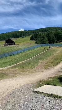
Course Preview: Evan Medcalf & Camden Rutherford Ride the iXS EDC #4 in Aprica, Italy
Jun 27, 2025 from pinkbike.com
A lap down the brand new track in Aprica.
Details Announced for Great Days Festival 2022 in Livigno
Jun 2, 2022 from pinkbike.com
The schedule includes lots of riding, parties with live music, the Tutti Frutti Challenge, and the Tk Avalanche descent.

Video: Ali Clarkson Ignites The New Bomb Enduro Trail in Livigno
Aug 2, 2019 from pinkbike.com
Ali Clarkson gets a sneak peak at the new 3km enduro trail
Event Report: Riding, Partying and More at Great Days 2019
Jul 24, 2019 from pinkbike.com
A mountain biking event that's a bit out of the ordinary in Livigno.
Sub Regions
- Aprica (41)
- Ardenno (16)
- Berbenno Di Valtellina (1)
- Bianzone (2)
- Bormio (41)
- Oga Natural Trails (13)
- Buglio In Monte (20)
- Caspoggio (33)
- Trail Zone Caspoggio (28)
- Chiareggio (8)
- Chiavenna (37)
- Chiesa in Valmalenco (59)
- Trail zone Palù Park (19)
- Delebio (1)
- Fusine (3)
- Gerola Alta (10)
- Grosio (12)
- Grosotto (1)
- Lanzada (20)
- Campo Moro (11)
- Livigno (68)
- Madesimo (11)
- MADE BIKE (7)
- Mantello (3)
- Mello (7)
- Morbegno (101)
- Bassa Valtellina (82)
- Piantedo (1)
- Piateda (3)
- Postalesio (20)
- Prata Camportaccio (15)
- San Martino (2)
- Santa Caterina Valfurva (42)
- Sondalo (24)
- Sondrio (42)
- Tartano (2)
- Teglio (31)
- Tirano (27)
- Torre Santa Maria (7)
- Valdidentro (72)
- Valdisotto (9)
- Valfurva (4)
- Verceia (3)
- Chiuro (1)
Popular Sondrio Mountain Biking Trails
• 100 ★ 4.4 • 1 mile • 0 ft • 1,318 •
Highly rated popular red difficulty singletrack. This mountain bike primary trail can be used downhill only and has a moderate overall physical rating. It features jump. On average it takes 9 minutes to complete this trail.
• 95 ★ 4.4 • 1 mile • 14 ft • 1,232 •
The creators of the more technical « » propose a more simple path but with some narrow transitions.
• 100 ★ 5.0 • 1,531 ft • 4 ft • 1,100 •
Breve, ma stretto ed esposto single track che corre sopra la SS38 dello Stelvio
• 80 ★ 4.3 • 1 mile • 19 ft • 1,043 •
A hybrid trail that combines the smooth riding style typical of flow with technical sections and a rapid succession of parabolic turns. A trail that passes through picturesque clearings and woodland. A treasure hidden among the trees...
• 20 ★ 4.2 • 1 mile • 0 ft • 1,016 •
Highly rated less popular red difficulty singletrack. This mountain bike primary trail can be used downhill only and has a moderate overall physical rating. It features jump. On average it takes 4 minutes to complete this trail.
• 90 ★ 4.3 • 2 miles • 18 ft • 963 •
A trail with real flowcountry features: a sequence of bends, parabolic turns and leaps with a slope always below 10° and a pace that allows you to almost never touch the pedals and brakes. A real with breathtaking views at the top and...
Sondrio Mountain Bike Routes
★ 4.5 • 34 miles • 11,312 ft • 6 • Point to Point •
The “Tutti Frutti Epic” MTB Tour is a one-day bucket-list ride that includes most of the new and...
★ 4.0 • 19 miles • 6,328 ft • 2 • Loop •
With this ride you will discover the true meaning of ‘Alpine cycling’. The Oblio di Zebruisus is...
★ 4.0 • 26 miles • 5,971 ft • 2 • Loop •
percorso vario con salite lunghe e impegnative sia su mulattiere e single track, alcuni tratti su asfalto...
★ 5.0 • 21 miles • 7,424 ft • 3 • Loop •
An unforgettable experience, among the trails and the mountains of Ortles Cevedale Group.
★ 5.0 • 12 miles • 3,460 ft • 1 • Loop •
The first part of this spectacular route takes you to the foot of the Forni glacier, the second part is a...
8 miles • 4,353 ft • 1 • Loop •
NEL TERRITORIO TRA LA VAL CODERA E LA VALLE DEI RATTI SI TROVA IL SENTIERO DEL TRACCIOLINO, UNA...
Photos of Sondrio Mountain Bike
Videos of Sondrio Mountain Bike
0:10 |
5 |
Jan 3, 2026
trail: The Bomb
8:13 |
45 |
Aug 15, 2024
trail: H-Dream (Hutr)
2:24 |
|
Aug 15, 2024
trail: Roller Coaster
3:05 |
19 |
Aug 15, 2024
0:16 |
82 |
Jul 31, 2023
trail: Carosello 3000
0:17 |
173 |
Jul 22, 2021
trail: Mottolino
0:13 |
115 |
Jul 21, 2021
trail: Only the brave
2:38 |
92 |
Dec 2, 2020
Current Trail Warnings
| status | trail | date | condition | user | info |
|---|---|---|---|---|---|
| Sentiero Caspoggio - Vassalini Caspoggio | Jun 14, 2026 @ 10:57am (Europe/Vaduz) Jun 14, 2026 | Ideal | Guret NORTHNLINE | Pulito recentemente | |
| Pital1 Bassa Valtellina | May 25, 2026 @ 1:27pm (America/Vancouver) May 25, 2026 | Very Dry | AlbertokKbRr1 | Trail asciuttissimo e con 10/20cm di... | |
| Taidadella + Tronchi Morbegno | May 24, 2026 @ 9:44pm (Europe/Rome) May 24, 2026 | Very Dry | Alterationn | lasciate stare |
Recent Trail Reports
National Scenic Trails & Official Routes
-
Trans-Altarezia Bike #32
- Mountain Bike
- E-Bike

Activity Feed
| username | action | type | title | date |
|---|---|---|---|---|
| tomminonthebike2012 | add | report | activity #97584773 | Jun 22, 2026 @ 2:17pm 2 hours |
| Pambry | difficultyvote | trail | activity #97559480 and 1 more | Jun 22, 2026 @ 7:10am 9 hours |
| Leaclp | wishlist | route | activity #97549512 | Jun 22, 2026 @ 2:13am 14 hours |
| pinkknip | add | photo | activity #97467250 and 4 more | Jun 21, 2026 @ 3:15am 2 days |
| pinkknip | add | report | activity #97462163 | Jun 21, 2026 @ 1:42am 2 days |
Recent Comments
| username | type | title | comment | date |
|---|---|---|---|---|
| trail | Se riesci a separare la parte alta “poco... | Jun 14, 2026 @ 12:09pm Jun 14, 2026 | ||
| trail | La prima parte della traccia è... | Jun 14, 2026 @ 6:23am Jun 14, 2026 | ||
| trail | Molto bella la prima parte nel bosco. Quando... | Jun 14, 2026 @ 6:13am Jun 14, 2026 | ||
| trail | Pista usata per la coppa italia trail... | Jun 12, 2026 @ 11:24pm Jun 12, 2026 | ||
| trail | Questo trail lo consiglio un sacco molto... | Jun 12, 2026 @ 11:22pm Jun 12, 2026 |
Local Badges
-

Big Ride 30k57 awarded -

Climbing 10k Badge13 awarded -

Mountain Biking 100k Badge0 awarded -

Epic Mountain Bike Climb 2k128 awarded -
Big Ride 30k20 awarded -
Big Ride 30k134 awarded
Bike & Skill Parks
| name | type | city | rating |
|---|---|---|---|
| Carosello 3000 Mountain Park | bike park | Livigno | |
| Mottolino Bike Park | bike park | Livigno | |
| MADE BIKE | bike park | Madesimo | |
| Mtb kids school | skill park | Santa Caterina Valfurva | |
| Poggiridenti Pump Track | skill park | Poggiridenti |
Local Products
Local Trail Association
Activity Type Stats
| activitytype | trails | distance | descent | descent distance | total vertical | rating | global rank | state rank | photos | reports | routes | ridelogs |
|---|---|---|---|---|---|---|---|---|---|---|---|---|
| Mountain Bike | 765 | 1,170 miles | 532,595 ft | 636 miles | 9,987 ft | 1,680 | 3,267 | 58 | 31,381 | |||
| E-Bike | 494 | 788 miles | 306,302 ft | 393 miles | 9,167 ft | 57 | 2,806 | 27 | 6,719 | |||
| Gravel Bike | 1 | 39 | 4 | 222 | ||||||||
| Adaptive Bike | 1 | 2 | 1 | |||||||||
| Winter Fat Bike | 3 | 4 | ||||||||||
| Horse | 29 | 78 miles | 12,388 ft | 24 miles | 9,065 ft | 178 | 1 | |||||
| Hike | 699 | 1,069 miles | 477,566 ft | 561 miles | 9,987 ft | 15 | 3,080 | 6 | 5,449 | |||
| Trail Running | 695 | 1,062 miles | 474,009 ft | 556 miles | 9,167 ft | 3,060 | 2 | 1,194 | ||||
| Snowmobile | 2 | 3 | ||||||||||
| Snowshoe | 18 | 42 miles | 10,230 ft | 16 miles | 6,001 ft | 14 | 102 | |||||
| Downhill Ski | 150 | 153 | 4,104 | |||||||||
| Backcountry Ski | 9 | 24 miles | 7,661 ft | 10 miles | 8,350 ft | 4 | 1,578 | |||||
| Nordic Ski | 8 | 8 miles | 1,368 ft | 2 miles | 3,140 ft | 8 | 2,047 |
Frequently Asked Questions About Sondrio
▼
What are the best places to ride in Sondrio?
Sondrio has 16 areas to explore for mountain biking. The top rated areas are:
▼
What are the highest rated mountain biking trails in Sondrio?
The highest rated mountain biking trails in Sondrio are:
- Panoramica (4.7/5)
- Valle Delle Mine (4.6/5)
- Le Cune (4.5/5)
- Passo Trela (4.5/5)
- Ponti Tibetani (4.5/5)
▼
What is the best time of the year to ride in Sondrio?
Based on ride log data, the most popular months to ride in Sondrio are:
- August (306 activities)
- July (296 activities)
- June (139 activities)
▼
What is the longest trail in Sondrio?
The longest trail in Sondrio is Sentiero Valtellina at 26.3 miles. View all trails sorted by distance.
Activities
Trails
Points of Interest
- Lago Azzurro Sight
- Rifugio Trona Soliva Cabin
- Nostra Signora d'Europa Sight
- Cable car Drop-off station Carosello 3000 Other
- Cable car Middle station Carosello 3000 Other
- Cable car Pick-up station Carosello 3000 Other
- TTF Glacier moraine Rock Garden
- [Mountain Pass] Passo San Marco 1991 m s.l.m. Other
- Cable car Pick-up station Other
- Ufficio turistico Information
- Bellavista Hauptgipfel (12,707 ft)
- Piz Zupò (12,648 ft)
- Schneekuppe (12,536 ft)
- By brenthillier
 NSMBA TRAILFORKS & contributors
 - Admins: denitopia, marcoangeletti, cemoorelife, marcoangeletti, adessoomaipiu, micheletraversi
- #9512 - 10,612 views
- sondrio activity log | embed map of Sondrio mountain bike trails | sondrio mountain biking points of interest
Downloading of trail gps tracks in kml & gpx formats is enabled for Sondrio.
You must login to download files.