close
-
Layers w
- Weather Layers
- Pro
- Pro
- Pro
- Pro
- Pro
- Pro
- More Layers
- Pro
- Pro
- Pro
- Pro
-
Upgrade to

3D
Trail Conditions
- Unknown
- Snow Groomed
- Snow Packed
- Snow Covered
- Snow Cover Partial
- Freeze/thaw Cycle
- Icy
- Prevalent Mud
- Wet
- Variable
- Ideal
- Dry
- Very Dry
Trail Flow (Ridden Direction)
Trailforks scans users ridelogs to determine the most popular direction each trail is ridden. A good flowing trail network will have most trails flowing in a single direction according to their intension.
The colour categories are based on what percentage of riders are riding a trail in its intended direction.
The colour categories are based on what percentage of riders are riding a trail in its intended direction.
- > 96%
- > 90%
- > 80%
- > 70%
- > 50%
- < 50%
- bi-directional trail
- no data
Trail Last Ridden
Trailforks scans ridelogs to determine the last time a trail was ridden.
- < 2 days
- < 1 week
- < 2 weeks
- < 1 month
- < 6 months
- > 6 months
Trail Ridden Direction
The intended direction a trail should be ridden.
- Downhill Only
- Downhill Primary
- Both Directions
- Uphill Primary
- Uphill Only
- One Direction
Contribute Details
Colors indicate trail is missing specified detail.
- Description
- Photos
- Description & Photos
- Videos
Trail Popularity ?
Trailforks scans ridelogs to determine which trails are ridden the most in the last 9 months.
Trails are compared with nearby trails in the same city region with a possible 25 colour shades.
Think of this as a heatmap, more rides = more kinetic energy = warmer colors.
- most popular
- popular
- less popular
- not popular
ATV/ORV/OHV Filter
Max Vehicle Width
inches
US Cell Coverage
Legend

Radar Time
Activity Recordings
Trailforks uses anonymized public activity data.
?
Activity Recordings
Trailforks uses anonymized public activity data.
?
Personal Heatmap
▶
Activity Types
all
/
none
▶
Options
2
Date range
month
–
Winter Trails
Warning
A routing network for winter maps does not exist. Selecting trails using the winter trails layer has been disabled.
Missing Trails
Most Popular
Least Popular
Trails are colored based on popularity. The more popular a trail is, the more red. Less popular trails trend towards green.
Jump Magnitude Heatmap
Heatmap of where riders jump on trails. Zoom in to see individual jumps, click circles to view jump details.
BC Backroad Status
![map legend]()
Service Road Atlas is a free to use, community-driven service for viewing and creating reports on the numerous back-country service roads around B.C. and Alberta.

Slope Aspect
Direction the slope faces
Trails Deemphasized
Trails are shown in grey.
Only show trails with no bike usage.
Suggested Layers
Based on selected activity type
Save the current map location and zoom level as your default home location whenever this page is loaded.
Save
No description for Sopot has been added yet!
Login or register to submit one.
This region uses the Uk/Euro style trail grading system.
Region Supporters & Maintainers
![]()
BigFoot WorksBuilder![]()
Trójmiejskie Ścieżki MTBMaintainer
Activities Click to view
- Mountain Bike
139 trails
- E-Bike
117 trails
- Gravel Bike
38 trails
- Adaptive Bike
40 trails
- Winter Fat Bike
1 trails
- Horse
0 trails
- Hike
86 trails
- Trail Running
86 trails
- Observed Trials
0 trails
- Snowshoe
0 trails
- Downhill Ski
0 trails
- Backcountry Ski
0 trails
- Nordic Ski
0 trails
Stats
- Avg Trail Rating
- Trails (view details)
- 140
- Trails Mountain Bike
- 139
- Trails E-Bike
- 117
- Trails Gravel Bike
- 38
- Trails Adaptive Bike
- 40
- Trails Winter Fat Bike
- 1
- Trails Hike
- 86
- Trails Trail Running
- 86
- Total Distance
- 55 miles
- Total Descent
- 11,892 ft
- Total Vertical
- 475 ft
- Highest Trailhead
- 536 ft
- Reports
- 4,588
- Photos
- 489
- Ridden Counter
- 27,924
Sub Regions
-
Ambona
- 7
- 16
- 13
-
BigFoot Works BikePark
- 7
- 16
- 13
-
Borodziej
- 1
-
Elektryczne
-
Epi Trails Sopocka
- 1
- 4
- 5
-
Las Sopocki
- 11
- 10
- 4
-
Malinowe
-
Smolna
- 1
- 1
-
Spacerowe
- 1
-
Zwierzyniec
- 1
Popular Sopot Mountain Biking Trails
• 10 ★ 4.6 • 719 ft • 0 ft • 253 •
Keep to left side of downhill section through roots and drops.
• 60 ★ 5.0 • 5,118 ft • 65 ft • 230 • • hike
Ścieżka piesza - piesi mają pierwszeństwo. Należy na nich uważać.
• 40 ★ 4.6 • 3,494 ft • 61 ft • 227 •
Highly rated moderately popular blue difficulty singletrack. This mountain bike primary trail and has a hard overall physical rating with a 61 ft black diamond climb. On average it takes 6 minutes to complete this trail.
• 65 ★ 4.5 • 1,339 ft • 0 ft • 210 •
Moderately popular blue difficulty singletrack. This mountain bike primary trail can be used downhill primary. On average it takes 4 minutes to complete this trail.
• 40 ★ 4.0 • 1,686 ft • 0 ft • 175 •
Moderately popular green difficulty singletrack. This mountain bike primary trail can be used downhill primary. On average it takes 1 minutes to complete this trail.
• 45 ★ 4.4 • 988 ft • 0 ft • 174 •
Moderately popular green difficulty singletrack. This mountain bike primary trail can be used downhill only. On average it takes 1 minutes to complete this trail.
• 40 ★ 5.0 • 4,554 ft • 47 ft • 159 •
Długi, kręty i łatwy singletrack ze znakomitym flow, w sam raz dla początkujących. Dedykowany do roweru MTB XC, ale sprawny gravelowiec też sobie poradzi. Ścieżka ma bardzo strategiczne położenie - łączy Drogę...
Sopot Mountain Bike Routes
6 miles • 721 ft • 8 • Loop • Race •
Prolog wyścigu Lotto MTB Energy 2021, dzień pierwszy, 3 czerwca 2021 To jest trasa wstępna i może ulec...
16 miles • 1,836 ft • 9 • Loop • Race •
Pierwszy etap wyścigu Lotto MTB Energy 2021, dzień drugi, 4 czerwca 2021 To jest trasa wstępna i może...
119 miles • 11,496 ft • 0 • Loop • Race •
Trasa ultramaratonu MTB "Czarne Serce", który odbył się 23 kwietnia 2022 roku. UWAGA: Czerwona...
123 miles • 12,002 ft • 0 • Loop • Race •
Wersja robocza trasy ultramaratonu MTB Czarne Serce 2023.
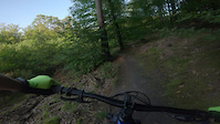
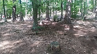
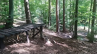
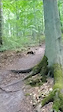
Photos of Sopot Mountain Bike
Videos of Sopot Mountain Bike
trail: Dolina Pioruna
0:11 |
96 |
Sep 13, 2023
0:07 |
52 |
Aug 17, 2022
0:11 |
87 |
Aug 17, 2022
trail: Kouty
0:07 |
246 |
Aug 17, 2022
trail: Chimera
0:08 |
150 |
Jul 17, 2022
trail: Iskra
0:16 |
108 |
Jul 10, 2022

trail: Schladming
0:29 |
229 |
Apr 3, 2022

trail: Champery
0:39 |
238 |
Mar 27, 2022
Recent Trail Reports
| status | trail | date | condition | info | user |
|---|---|---|---|---|---|
| Zagubiona Ścieżka | Jun 16, 2026 @ 5:47pm (Europe/Warsaw) Jun 16, 2026 | Variable | karczk | ||
| Kraniec | Jun 12, 2026 @ 2:17pm (Europe/Kaliningrad) Jun 12, 2026 | Ideal | jdarski | ||
| Droga Nadleśniczych | Jun 12, 2026 @ 2:17pm (Europe/Kaliningrad) Jun 12, 2026 | Ideal | jdarski | ||
| Ukośny Łącznik | Jun 6, 2026 @ 11:55am (Europe/Kaliningrad) Jun 6, 2026 | Ideal | jdarski | ||
| Obwodowa | May 27, 2026 @ 3:57pm (Europe/Kaliningrad) May 27, 2026 | Ideal | jdarski | ||
| Forest Road | May 27, 2026 @ 3:57pm (Europe/Kaliningrad) May 27, 2026 | Dry | jdarski | ||
| Gołębiewo - Wielka Gwiazda | May 27, 2026 @ 3:57pm (Europe/Kaliningrad) May 27, 2026 | Ideal | jdarski | ||
| Access Trail | May 26, 2026 @ 4:47pm (Europe/Warsaw) May 26, 2026 | Dry | voigtkampff | ||
| Koncert | May 26, 2026 @ 4:47pm (Europe/Warsaw) May 26, 2026 | Dry | voigtkampff | ||
| Zawrotna Dolina | May 22, 2026 @ 6:11pm (Europe/Kaliningrad) May 22, 2026 | Ideal | jdarski |
Activity Feed
| username | action | type | title | date |
|---|---|---|---|---|
| karczk | add | report | activity #97113728 | Jun 16, 2026 @ 8:47am Jun 16, 2026 |
| jdarski | add | report | activity #96801030 and 1 more | Jun 12, 2026 @ 7:02am Jun 12, 2026 |
| jdarski | add | report | activity #96363980 and 1 more | Jun 6, 2026 @ 6:34am Jun 6, 2026 |
| Wojasz | wishlist | route | activity #95799236 | May 29, 2026 @ 1:33pm May 29, 2026 |
| Wojasz | ridden | route | activity #95799203 | May 29, 2026 @ 1:32pm May 29, 2026 |
Recent Comments
| username | type | title | comment | date |
|---|---|---|---|---|
| report | a. qpedz | May 12, 2026 @ 9:14am May 12, 2026 | ||
| report | pqzqq | May 12, 2026 @ 9:12am May 12, 2026 | ||
| report | ad wd d po ti w po do ps wia w | May 12, 2026 @ 9:11am May 12, 2026 | ||
| report | Proszę cię wyślij | May 12, 2026 @ 9:10am May 12, 2026 | ||
| report | ly l kka us elekMzy | May 12, 2026 @ 9:10am May 12, 2026 |
Local Badges
-

Top 10 Trails6 awarded -

Descent 100k Badge7 awarded -

Big Ride 30k3,537 awarded -

Epic Ride 50k859 awarded -

Descent 10k Badge156 awarded -

Completionist0 awarded
Bike & Skill Parks
| name | type | city | rating |
|---|---|---|---|
| Borodziej | skill park | Sopot | |
| Smolna | skill park | Sopot | |
| Malinowe BFW | skill park | Sopot | |
| Ambona BFW | skill park | Sopot | |
| Spacerowe BFW | skill park | Sopot |
Activity Type Stats
| activitytype | trails | distance | descent | descent distance | total vertical | rating | global rank | state rank | photos | reports | routes | ridelogs |
|---|---|---|---|---|---|---|---|---|---|---|---|---|
| Mountain Bike | 139 | 54 miles | 11,650 ft | 33 miles | 476 ft | #299 | #5 | 484 | 4,587 | 12 | 29,220 | |
| E-Bike | 117 | 47 miles | 10,810 ft | 31 miles | 472 ft | #375 | #261 | 4 | 4,312 | 3,225 | ||
| Gravel Bike | 38 | 22 miles | 2,631 ft | 12 miles | 364 ft | #58 | #56 | 947 | 271 | |||
| Adaptive Bike | 40 | 25 miles | 2,785 ft | 13 miles | 367 ft | #43 | #75 | 1,713 | ||||
| Winter Fat Bike | 1 | 902 ft | 26 ft | 276 ft | 26 ft | #58 | #50 | 52 | ||||
| Hike | 86 | 41 miles | 6,220 ft | 22 miles | 476 ft | #566 | #31 | 3,946 | 647 | |||
| Trail Running | 86 | 41 miles | 6,220 ft | 22 miles | 476 ft | #1,002 | #30 | 3,946 | 447 |
Frequently Asked Questions About Sopot
▼
What are the best places to ride in Sopot?
Sopot has 10 areas to explore for mountain biking. The top rated areas are:
▼
What are the highest rated mountain biking trails in Sopot?
The highest rated mountain biking trails in Sopot are:
- Zdyszany jak Pies (4.5/5)
- Mchowy (4.5/5)
- Zagubiona Ścieżka (4.4/5)
- Schladming (4.4/5)
- Wihajster (4.3/5)
▼
What is the best time of the year to ride in Sopot?
Based on ride log data, the most popular months to ride in Sopot are:
- July (201 activities)
- June (192 activities)
- September (190 activities)
▼
Where can I park to ride in Sopot?
Activities
Trails
- By micolai
 TRAILFORKS Poland & contributors
 - Admins: PMBA, Poland, BFW
- #10611 - 16,770 views
- sopot activity log | embed map of Sopot mountain bike trails | sopot mountain biking points of interest polygons
Downloading of trail gps tracks in kml & gpx formats is enabled for Sopot.
You must login to download files.