close
-
Layers w
- Weather Layers
- Pro
- Pro
- Pro
- Pro
- Pro
- Pro
- More Layers
- Pro
- Pro
- Pro
- Pro
-
Upgrade to

3D
Trail Conditions
- Unknown
- Snow Groomed
- Snow Packed
- Snow Covered
- Snow Cover Partial
- Freeze/thaw Cycle
- Icy
- Prevalent Mud
- Wet
- Variable
- Ideal
- Dry
- Very Dry
Trail Flow (Ridden Direction)
Trailforks scans users ridelogs to determine the most popular direction each trail is ridden. A good flowing trail network will have most trails flowing in a single direction according to their intension.
The colour categories are based on what percentage of riders are riding a trail in its intended direction.
The colour categories are based on what percentage of riders are riding a trail in its intended direction.
- > 96%
- > 90%
- > 80%
- > 70%
- > 50%
- < 50%
- bi-directional trail
- no data
Trail Last Ridden
Trailforks scans ridelogs to determine the last time a trail was ridden.
- < 2 days
- < 1 week
- < 2 weeks
- < 1 month
- < 6 months
- > 6 months
Trail Ridden Direction
The intended direction a trail should be ridden.
- Downhill Only
- Downhill Primary
- Both Directions
- Uphill Primary
- Uphill Only
- One Direction
Contribute Details
Colors indicate trail is missing specified detail.
- Description
- Photos
- Description & Photos
- Videos
Trail Popularity ?
Trailforks scans ridelogs to determine which trails are ridden the most in the last 9 months.
Trails are compared with nearby trails in the same city region with a possible 25 colour shades.
Think of this as a heatmap, more rides = more kinetic energy = warmer colors.
- most popular
- popular
- less popular
- not popular
ATV/ORV/OHV Filter
Max Vehicle Width
inches
US Cell Coverage
Legend

Radar Time
Activity Recordings
Trailforks uses anonymized public activity data.
?
Activity Recordings
Trailforks uses anonymized public activity data.
?
Personal Heatmap
▶
Activity Types
all
/
none
▶
Options
2
Date range
month
–
Winter Trails
Warning
A routing network for winter maps does not exist. Selecting trails using the winter trails layer has been disabled.
Missing Trails
Most Popular
Least Popular
Trails are colored based on popularity. The more popular a trail is, the more red. Less popular trails trend towards green.
Jump Magnitude Heatmap
Heatmap of where riders jump on trails. Zoom in to see individual jumps, click circles to view jump details.
BC Backroad Status
![map legend]()
Service Road Atlas is a free to use, community-driven service for viewing and creating reports on the numerous back-country service roads around B.C. and Alberta.

Slope Aspect
Direction the slope faces
Trails Deemphasized
Trails are shown in grey.
Only show trails with no bike usage.
Suggested Layers
Based on selected activity type
Save the current map location and zoom level as your default home location whenever this page is loaded.
SaveWelcome to the South Lakeside Trail Network, featuring:
• Mostly forested trails with some great viewpoints
• Many trail options: lots of great X-C style riding; climbs are all singletrack; descents are your choice of mellow or more challenging.
• Easy shuttle to the top of the network (P4 on Dog Creek Rd at the top of Twizzler)
• For self-propelled riders, the commonest entry point is the bottom of Moose Drop off South Lakeside Drive. See Moose Drop trail description for parking options.
• You can connect to the Westsyde network via Doggone and Bellie X-C for a more extended ride (connection involves a short ride on pavement)
• Best choice for riding in very hot weather
This area lies on the Traditional Territory of the Northern Shuswap; please ride with respect.
Help support our trail network, purchase your Williams Lake Cycling Club membership here
source: ...
Primary Trail Type: Cross-Country
AKA: Southside
 google parking directions
 Activities Click to view
- Mountain Bike
52 trails
- Hike
51 trails
- Trail Running
51 trails
Region Details
- 6
- 1
- 28
- 8
Region Status
Open as of 11 hoursStats
- Avg Trail Rating
- Trails (view details)
- 43
- Trails Mountain Bike
- 52
- Trails E-Bike
- 10
- Trails Gravel Bike
- 4
- Trails Adaptive Bike
- 3
- Trails Winter Fat Bike
- 1
- Trails Hike
- 51
- Trails Trail Running
- 51
- Trails Dirtbike/Moto
- 10
- Total Distance
- 40 miles
- Total Descent
- 11,484 ft
- Total Vertical
- 1,101 ft
- Highest Trailhead
- 3,031 ft
- Reports
- 615
- Photos
- 120
- Ridden Counter
- 2,540
Popular South Side Mountain Biking Trails
• 100 ★ 2.0 • 1,115 ft • 80 ft • 179 •
• 2-way side loop off the lower part of . A climbing-friendly detour off on the way up from the Walmart area. • Most popular climbing route into the South Lakeside Network.
• 95 ★ 1.5 • 5,026 ft • 287 ft • 152 •
Most popular climbing route to get you up into the Southside network.
• 85 ★ 3.0 • 1 mile • 21 ft • 145 •
This is the main access into the bottom of the Southside network. Rather than park across South Lakeside Drive as indicated by the "P", most locals are now parking in the NE corner of the Walmart Parking lot, which saves a punchy...
• 90 ★ 4.0 • 1 mile • 4 ft • 130 •
Fun, fast, and flowy single track line linking to , , and . Intermediate trail but fun for anybody.
• 75 ★ 4.0 • 2 miles • 201 ft • 125 •
• Popular X-C trail always ridden one way from the end. Fairly flat elevation profile and fairly easy x-c pedalling except for a 300 metre long rocky section along a boulder-strewn canyon edge which provides a short section of...
• 85 ★ 3.3 • 4,787 ft • 272 ft • 95 •
A local favourite. Sweet and flowy singletrack.
South Side Mountain Bike Routes
9 miles • 1,525 ft • 8 • Loop •
15km loop with great views overlooking Williams Lake
10 miles • 1,572 ft • 20 •
A classic Southside loop featuring Dick's trail and Jaden. Relatively long but rideable climb to begin,...
• 8 miles • 1,584 ft • 7 •
• 8 miles • 1,033 ft • 3 •
• 7 miles • 1,024 ft • 3 •
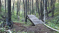
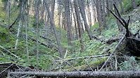
Photos of South Side Mountain Bike
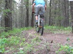
Videos of South Side Mountain Bike
trail: Freshly Trimmed
0:19 |
291 |
Sep 3, 2020
trail: Freshly Trimmed
0:19 |
176 |
Sep 3, 2020
trail: Radbitz
0:56 |
415 |
Jun 28, 2010
Current Trail Warnings
| status | trail | date | condition | user | info |
|---|---|---|---|---|---|
| Kenny's Krack | Jun 7, 2026 @ 12:24pm (America/Vancouver) Jun 7, 2026 | Unknown | Hutchbiker WLCC |
Recent Trail Reports
| status | trail | date | condition | info | user |
|---|---|---|---|---|---|
| Twizzler | Jun 21, 2026 @ 8:40am (America/Vancouver) 11 hours | Unknown | Tayloraeichele9 | ||
| P-Trail | May 29, 2026 @ 12:35pm (America/Vancouver) May 29, 2026 | Unknown | GeraldFroese | ||
| Cabin Loop | May 20, 2026 @ 12:34pm (America/Los_Angeles) May 20, 2026 | Variable | Barkingspider WLCC | ||
| Deer Bedz | May 7, 2026 @ 6:55am (America/Vancouver) May 7, 2026 | Dry | fulty WLCC | ||
| Jaeden | May 6, 2026 @ 6:14pm (America/Vancouver) May 6, 2026 | Dry | fulty WLCC | ||
| Allsorts | May 4, 2026 @ 3:16pm (America/Vancouver) May 4, 2026 | Dry | fulty WLCC | ||
| Rotnee shortcut | May 3, 2026 @ 12:48pm (America/Vancouver) May 3, 2026 | Dry | fulty WLCC | ||
| Nibbs | May 3, 2026 @ 12:48pm (America/Vancouver) May 3, 2026 | Dry | fulty WLCC | ||
| Moose Drop | May 2, 2026 @ 8:57am (America/Vancouver) May 2, 2026 | Ideal | cdnmtbkr | ||
| Dirty Branchez | May 2, 2026 @ 8:57am (America/Vancouver) May 2, 2026 | Ideal | cdnmtbkr |
Activity Feed
| username | action | type | title | date |
|---|---|---|---|---|
| Tayloraeichele9 | add | report | activity #97488724 | Jun 21, 2026 @ 8:40am 11 hours |
| Hutchbiker | add | report | activity #96487581 | Jun 7, 2026 @ 12:24pm Jun 7, 2026 |
| TrevorSowersXc2 | wishlist | trail | activity #96226166 and 2 more | Jun 4, 2026 @ 7:31am Jun 4, 2026 |
| GeraldFroese | add | report | activity #95795840 | May 29, 2026 @ 12:35pm May 29, 2026 |
| fulty | update | trail | activity #95596423 | May 26, 2026 @ 4:09pm May 26, 2026 |
Recent Comments
| username | type | title | comment | date |
|---|---|---|---|---|
| trail | Hopefully you read my comment on the first... | Sep 17, 2025 @ 12:22pm Sep 17, 2025 | ||
| trail | Despite the fact that this is absolutely NOT a... | Sep 17, 2025 @ 12:13pm Sep 17, 2025 | ||
| report | Cleared | Mar 23, 2025 @ 10:58pm Mar 23, 2025 | ||
| report | Trees cleared | Sep 9, 2024 @ 9:33pm Sep 9, 2024 | ||
| report | Tree cleared | May 30, 2024 @ 10:31am May 30, 2024 |
Nearby Areas
| name | distance | ||||
|---|---|---|---|---|---|
| Fox Mountain | 13 | 26 | 15 | 3 | 2.9 km |
| Chief Will Yum | 1 | 2 | 1 | 4.4 km | |
| Westsyde | 12 | 25 | 13 | 1 | 5.4 km |
| Desous | 3 | 5 | 11 | 1 | 10.1 km |
| Chimney Lake | 5 | 14 | 12.8 km |
Local Badges
-

Completionist1 awarded
Local Mountain Biking Directory
-
Williams Lake Cycling Club
![Williams Lake Cycling Club]()
-
Fox Mountain Brewing Co.
-
Ride The CaribooTrail Association
![Ride The Cariboo]()
-
Red Shreds Bike & Board shedBike Shop
![Red Shreds Bike & Board shed]()
Activity Type Stats
| activitytype | trails | distance | descent | descent distance | total vertical | rating | global rank | state rank | photos | reports | routes | ridelogs |
|---|---|---|---|---|---|---|---|---|---|---|---|---|
| Mountain Bike | 52 | 40 miles | 11,483 ft | 22 miles | 1,102 ft | #4,136 | #176 | 90 | 615 | 3 | 2,156 | |
| E-Bike | 10 | 1 mile | 92 ft | 1,870 ft | 59 ft | 342 | 78 | |||||
| Gravel Bike | 4 | #3,565 | #207 | 14 | ||||||||
| Adaptive Bike | 3 | #3,575 | #207 | |||||||||
| Winter Fat Bike | 1 | #3,565 | #207 | |||||||||
| Hike | 51 | 39 miles | 11,161 ft | 21 miles | 1,102 ft | #2,625 | #115 | 28 | 589 | 1 | 213 | |
| Trail Running | 51 | 39 miles | 11,161 ft | 21 miles | 1,102 ft | #4,363 | #146 | 586 | 1 | 63 | ||
| Dirtbike/Moto | 10 | 1 mile | 92 ft | 1,870 ft | 59 ft | 161 | 3 |
Frequently Asked Questions About South Side
▼
What are the highest rated mountain biking trails in South Side?
The highest rated mountain biking trails in South Side are:
- Rim Job (4.2/5)
- Billy Goat (4.1/5)
- Russet Bluff trail (4.1/5)
- Nerdee (4.1/5)
- Rotnee (4/5)
▼
What is the best time of the year to ride in South Side?
Based on ride log data, the most popular months to ride in South Side are:
- July (72 activities)
- June (67 activities)
- May (64 activities)
▼
Where can I park to ride in South Side?
▼
What is the longest trail in South Side?
The longest trail in South Side is Nerdee at 2.9 miles. View all trails sorted by distance.
Activities
Trails
- By brenthillier
 NSMBA TRAILFORKS & contributors
 - Admins: CMBC, WLCC, RSTBC
- #3333 - 6,846 views
- south side activity log | embed map of South Side mountain bike trails | south side mountain biking points of interest
Downloading of trail gps tracks in kml & gpx formats is enabled for South Side.
You must login to download files.