close
-
Layers w
- Weather Layers
- Pro
- Pro
- Pro
- Pro
- Pro
- Pro
- More Layers
- Pro
- Pro
- Pro
- Pro
-
Upgrade to

3D
Trail Conditions
- Unknown
- Snow Groomed
- Snow Packed
- Snow Covered
- Snow Cover Partial
- Freeze/thaw Cycle
- Icy
- Prevalent Mud
- Wet
- Variable
- Ideal
- Dry
- Very Dry
Trail Flow (Ridden Direction)
Trailforks scans users ridelogs to determine the most popular direction each trail is ridden. A good flowing trail network will have most trails flowing in a single direction according to their intension.
The colour categories are based on what percentage of riders are riding a trail in its intended direction.
The colour categories are based on what percentage of riders are riding a trail in its intended direction.
- > 96%
- > 90%
- > 80%
- > 70%
- > 50%
- < 50%
- bi-directional trail
- no data
Trail Last Ridden
Trailforks scans ridelogs to determine the last time a trail was ridden.
- < 2 days
- < 1 week
- < 2 weeks
- < 1 month
- < 6 months
- > 6 months
Trail Ridden Direction
The intended direction a trail should be ridden.
- Downhill Only
- Downhill Primary
- Both Directions
- Uphill Primary
- Uphill Only
- One Direction
Contribute Details
Colors indicate trail is missing specified detail.
- Description
- Photos
- Description & Photos
- Videos
Trail Popularity ?
Trailforks scans ridelogs to determine which trails are ridden the most in the last 9 months.
Trails are compared with nearby trails in the same city region with a possible 25 colour shades.
Think of this as a heatmap, more rides = more kinetic energy = warmer colors.
- most popular
- popular
- less popular
- not popular
ATV/ORV/OHV Filter
Max Vehicle Width
inches
US Cell Coverage
Legend

Radar Time
Activity Recordings
Trailforks uses anonymized public activity data.
?
Activity Recordings
Trailforks uses anonymized public activity data.
?
Personal Heatmap
▶
Activity Types
all
/
none
▶
Options
2
Date range
month
–
Winter Trails
Warning
A routing network for winter maps does not exist. Selecting trails using the winter trails layer has been disabled.
Missing Trails
Most Popular
Least Popular
Trails are colored based on popularity. The more popular a trail is, the more red. Less popular trails trend towards green.
Jump Magnitude Heatmap
Heatmap of where riders jump on trails. Zoom in to see individual jumps, click circles to view jump details.
BC Backroad Status
![map legend]()
Service Road Atlas is a free to use, community-driven service for viewing and creating reports on the numerous back-country service roads around B.C. and Alberta.

Slope Aspect
Direction the slope faces
Trails Deemphasized
Trails are shown in grey.
Only show trails with no bike usage.
Suggested Layers
Based on selected activity type
Save the current map location and zoom level as your default home location whenever this page is loaded.
Save
No description for Sparwood has been added yet!
Login or register to submit one.
Activities Click to view
- Mountain Bike
54 trails
- E-Bike
20 trails
- Gravel Bike
1 trails
- Adaptive Bike
0 trails
- Horse
5 trails
- Hike
65 trails
- Trail Running
64 trails
- Snowshoe
22 trails
Region Details
- 11
- 18
- 19
- 5
Region Status
Caution as of 1 dayStats
- Avg Trail Rating
- Trails (view details)
- 54
- Trails Mountain Bike
- 54
- Trails E-Bike
- 20
- Trails Gravel Bike
- 1
- Trails Winter Fat Bike
- 1
- Trails Horse
- 5
- Trails Hike
- 65
- Trails Trail Running
- 64
- Trails Dirtbike/Moto
- 3
- Trails Observed Trials
- 2
- Trails ATV/ORV/OHV
- 3
- Trails Snowmobile
- 2
- Trails Snowshoe
- 22
- Trails Downhill Ski
- 2
- Trails Backcountry Ski
- 2
- Trails Nordic Ski
- 2
- Total Distance
- 59 miles
- Total Descent
- 6,620 ft
- Total Vertical
- 1,157 ft
- Highest Trailhead
- 4,663 ft
- Reports
- 398
- Photos
- 186
- Ridden Counter
- 4,501
Sub Regions
-
Sparwood Ridge
- 14
- 16
- 3
Popular Sparwood Mountain Biking Trails
• 100 ★ 4.2 • 1 mile • 283 ft • 290 •
It is best to ride counter clockwise, although it is rideable in both directions.
• 100 ★ 4.5 • 4,623 ft • 47 ft • 237 •
is longest stretch of trail with in the network. With over 140 rollers, a few drops and gap jumps to entertain you as you pump your way down the trail.
• 100 ★ 3.0 • 2,421 ft • 32 ft • 215 •
is section of trail, that takes you back on some single track back into the woods. Trail was developed to get off the , to eliminate the muddy road section.
• 85 ★ 0.0 • 328 ft • 12 ft • 178 •
Trail is a double track access to the trail network.
• 75 ★ 0.0 • 4,190 ft • 122 ft • 163 •
Popular blue difficulty singletrack. This multi-use trail can be used both directions and has a easy overall physical rating with a 122 ft blue climb. Trail visibility is always easy to follow. On average it takes 8 minutes to complete this trail.
• 80 ★ 4.0 • 1,417 ft • 0 ft • 149 •
Flow trail with berms and jumps with a few gap jumps.
• 75 ★ 5.0 • 1,824 ft • 14 ft • 142 •
Flowy trail with a few sweeping berms. Spectacular view point down the Elk Valley.
Sparwood Mountain Bike Routes
★ 3.0 • 30 miles • 1,551 ft • 7 • Point to Point •
The Great Trail (aka Trans Canada Trail) from Sparwood to Elkford. Also part of The Elk Valley Trail....
2 miles • 118 ft • 0 •
A route that passes through suburbs of the heights, utilizing parts of the Road, a Power Line, Cypress...
★ 3.0 • 3 miles • 660 ft • 0 • Out & Back •
A shorter options up to "The Look Out" from parking next to Fiorentino Contracting work shop.
★ 1.0 • 30 miles • 3,441 ft • 9 • Race •
Stage 2 of Fernie Singletrack 3 will take you from the little mining town of Sparwood all the way back to...
Photos of Sparwood Mountain Bike
Videos of Sparwood Mountain Bike
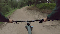
trail: Eh-Line
3:12 |
417 |
Jul 14, 2025

trail: Sloppy Joe
7:15 |
209 |
May 12, 2022 , Sparwood

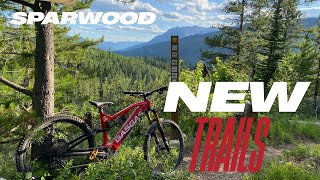
trail: Lunch $$$
7:15 |
193 |
May 12, 2022 , Sparwood
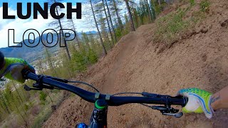
trail: Lunch Loop
7:15 |
548 |
May 12, 2022 , Sparwood
Recent Trail Reports
Activity Feed
| username | action | type | title | date |
|---|---|---|---|---|
| bakerbrook1 | add | report | activity #97343343 | Jun 19, 2026 @ 2:02pm 1 day |
| TransRockies-Events | update | route | activity #97317292 | Jun 19, 2026 @ 7:50am 1 day |
| Oddbjorn | wishlist | route | activity #97289610 | Jun 18, 2026 @ 6:48pm 2 days |
| TransRockies-Events | add | poi | activity #97284800 and 2 more | Jun 18, 2026 @ 5:13pm 2 days |
| TransRockies-Events | update | route | activity #97284747 | Jun 18, 2026 @ 5:13pm 2 days |
Recent Comments
| username | type | title | comment | date |
|---|---|---|---|---|
| trail | Fun trail! Definitely a similar feeling as... | Jun 14, 2026 @ 3:38pm Jun 14, 2026 | ||
| trail | Awesome trail, need a bit more clean up for... | Jun 14, 2026 @ 7:07am Jun 14, 2026 | ||
| report | The trail is currently in a freeze–thaw... | Apr 1, 2026 @ 4:43am Apr 1, 2026 | ||
| trail | Caution riding any of the wooden features.... | Aug 18, 2025 @ 4:54am Aug 18, 2025 | ||
| trail | Awesome trail! Great wooden features. But... | Aug 9, 2025 @ 4:52pm Aug 9, 2025 |
Local Badges
-

Epic Ride Climb 2k13 awarded -

Climbing 10k Badge25 awarded -

Climbing 100k Badge2 awarded -

Epic Ride Descent 2k13 awarded -

Descent 10k Badge25 awarded -

Descent 100k Badge2 awarded
Local Trail Supporters
![Columbia Basin Trust]()
![]()
![]()
- District of sparwood
- Elk Valley Resources
- Pacific Economic Development Canada (PacifiCan)
![TECK]()
- Pacific Economic Development Canada (PacifiCan)
- Teck Coal
Activity Type Stats
| activitytype | trails | distance | descent | descent distance | total vertical | rating | global rank | state rank | photos | reports | routes | ridelogs |
|---|---|---|---|---|---|---|---|---|---|---|---|---|
| Mountain Bike | 54 | 58 miles | 5,758 ft | 22 miles | 1,119 ft | #2,538 | #78 | 180 | 395 | 6 | 6,270 | |
| E-Bike | 20 | 17 miles | 725 ft | 6 miles | 827 ft | #4,935 | #99 | 194 | 1 | 123 | ||
| Gravel Bike | 1 | #535 | #104 | 2 | 8 | |||||||
| Winter Fat Bike | 1 | #5,734 | #121 | 15 | 9 | |||||||
| Horse | 5 | 5 miles | 997 ft | 2 miles | 919 ft | #2,090 | #65 | 8 | 2 | |||
| Hike | 65 | 59 miles | 6,621 ft | 23 miles | 1,158 ft | #3,869 | #104 | 6 | 395 | 2 | 935 | |
| Trail Running | 64 | 59 miles | 6,621 ft | 23 miles | 1,158 ft | #3,461 | #88 | 394 | 2 | 593 | ||
| Dirtbike/Moto | 3 | 1 mile | 863 ft | 1 mile | 863 ft | 5 | 3 | |||||
| Observed Trials | 2 | 600 ft | 23 ft | 600 ft | 26 ft | |||||||
| ATV/ORV/OHV | 3 | 1 mile | 863 ft | 1 mile | 863 ft | 5 | 5 | |||||
| Snowmobile | 2 | 5 | ||||||||||
| Snowshoe | 22 | 18 miles | 2,201 ft | 7 miles | 863 ft | #622 | #49 | 91 | 2 | 156 | ||
| Downhill Ski | 2 | 2 | ||||||||||
| Backcountry Ski | 2 | 32 | ||||||||||
| Nordic Ski | 2 | 2 miles | 56 ft | 3,901 ft | 33 ft | 5 | 189 |
Frequently Asked Questions About Sparwood
▼
What are the best places to ride in Sparwood?
Sparwood has 1 areas to explore for mountain biking. The top rated areas are:
▼
What are the highest rated mountain biking trails in Sparwood?
The highest rated mountain biking trails in Sparwood are:
- Smoko (4.1/5)
- Blue Collar Down Country (4.1/5)
- Match Burner (4.1/5)
- 2nd Helping (4.1/5)
- No Regerts (4.1/5)
▼
What is the best time of the year to ride in Sparwood?
Based on ride log data, the most popular months to ride in Sparwood are:
- July (103 activities)
- August (64 activities)
- May (53 activities)
▼
Where can I park to ride in Sparwood?
There are 7 parking locations listed in Sparwood. The most popular parking spots are: View all parking and trailhead locations on the map to plan your visit.
Activities
Trails
- By bullitxl & contributors
- Admins: barry-mclane, STA, STMS, RDEK
- #4429 - 14,464 views
- sparwood activity log | embed map of Sparwood mountain bike trails | sparwood mountain biking points of interest
Downloading of trail gps tracks in kml & gpx formats is enabled for Sparwood.
You must login to download files.