close
-
Layers w
- Weather Layers
- Pro
- Pro
- Pro
- Pro
- Pro
- Pro
- More Layers
- Pro
- Pro
- Pro
- Pro
-
Upgrade to

3D
Trail Conditions
- Unknown
- Snow Groomed
- Snow Packed
- Snow Covered
- Snow Cover Partial
- Freeze/thaw Cycle
- Icy
- Prevalent Mud
- Wet
- Variable
- Ideal
- Dry
- Very Dry
Trail Flow (Ridden Direction)
Trailforks scans users ridelogs to determine the most popular direction each trail is ridden. A good flowing trail network will have most trails flowing in a single direction according to their intension.
The colour categories are based on what percentage of riders are riding a trail in its intended direction.
The colour categories are based on what percentage of riders are riding a trail in its intended direction.
- > 96%
- > 90%
- > 80%
- > 70%
- > 50%
- < 50%
- bi-directional trail
- no data
Trail Last Ridden
Trailforks scans ridelogs to determine the last time a trail was ridden.
- < 2 days
- < 1 week
- < 2 weeks
- < 1 month
- < 6 months
- > 6 months
Trail Ridden Direction
The intended direction a trail should be ridden.
- Downhill Only
- Downhill Primary
- Both Directions
- Uphill Primary
- Uphill Only
- One Direction
Contribute Details
Colors indicate trail is missing specified detail.
- Description
- Photos
- Description & Photos
- Videos
Trail Popularity ?
Trailforks scans ridelogs to determine which trails are ridden the most in the last 9 months.
Trails are compared with nearby trails in the same city region with a possible 25 colour shades.
Think of this as a heatmap, more rides = more kinetic energy = warmer colors.
- most popular
- popular
- less popular
- not popular
ATV/ORV/OHV Filter
Max Vehicle Width
inches
US Cell Coverage
Legend

Radar Time
Activity Recordings
Trailforks uses anonymized public activity data.
?
Activity Recordings
Trailforks uses anonymized public activity data.
?
Personal Heatmap
▶
Activity Types
all
/
none
▶
Options
2
Date range
month
–
Winter Trails
Warning
A routing network for winter maps does not exist. Selecting trails using the winter trails layer has been disabled.
Missing Trails
Most Popular
Least Popular
Trails are colored based on popularity. The more popular a trail is, the more red. Less popular trails trend towards green.
Jump Magnitude Heatmap
Heatmap of where riders jump on trails. Zoom in to see individual jumps, click circles to view jump details.
BC Backroad Status
![map legend]()
Service Road Atlas is a free to use, community-driven service for viewing and creating reports on the numerous back-country service roads around B.C. and Alberta.

Slope Aspect
Direction the slope faces
Trails Deemphasized
Trails are shown in grey.
Only show trails with no bike usage.
Suggested Layers
Based on selected activity type
Save the current map location and zoom level as your default home location whenever this page is loaded.
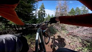
SaveSpence Mountain is a 7500 acre multi-use trail region that is now owned by Klamath County. It currently has slightly more than 50 miles of professionally-built trails courtesy of Dirt Mechanics (Paul Lissette) and Terra Velo (Paul Thomasberg). It is about 10 miles northwest of Klamath Falls, OR along Hwy 140W. It has a range of trails from family-oriented (Red Rover), cross country, Jump Line (Speed King), Downhill (North ridge and Nighthawk). Elevation range is between 4150 and 5850 ft.
Primary Trail Type: Cross-Country
eBikes Allowed:
Yes
AKA: Spence
Land Status: County Park
 google parking directions
 Access Info:
Spence Trail head is located on highway 140 just uphill from the edge of Klamath Lake about 10 miles north of Klamath Falls. Shoalwater Bay Trail head is accessed by going another 5 miles north over Doak summit. At the bottom of the other side turn north on Eagle Ridge Road and the tail head is about 2 miles in on the left.
Activities Click to view
- Mountain Bike
54 trails
- E-Bike
54 trails
- Hike
49 trails
- Trail Running
50 trails
Region Details
- 13
- 11
- 19
- 11
Region Status
Open as of Jun 5, 2026Stats
- Avg Trail Rating
- Trails (view details)
- 54
- Trails Mountain Bike
- 54
- Trails E-Bike
- 54
- Trails Adaptive Bike
- 1
- Trails Hike
- 49
- Trails Trail Running
- 50
- Total Distance
- 53 miles
- Total Descent
- 8,393 ft
- Total Vertical
- 1,696 ft
- Highest Trailhead
- 5,844 ft
- Reports
- 542
- Photos
- 143
- Ridden Counter
- 7,693
Popular Spence Mountain Mountain Biking Trails
• 100 ★ 4.5 • 5 miles • 1,383 ft • 628 •
This trail is predominantly uphill but can be ridden both ways. The lower half gets a fair amount of hikers, so downhill traffic should be careful. This is a fairly classic singletrack using existing rocks for features - all climbable,...
• 100 ★ 3.5 • 1,250 ft • 3 ft • 522 •
Hand-built during an IMBA trail meeting a couple years ago. A little rocky, and a nice bermed corner.
• 90 ★ 3.9 • 2 miles • 32 ft • 518 •
This is a downhill one-way flow trail. The first mile has lots of berms, tabletops and small jumps. The last mile of the trail is a little narrower in the trees with short rocky sections, but nothing to slow you down too much.
• 75 ★ 4.4 • 2 miles • 160 ft • 376 •
will start as a fun "enduro" style DH trail with berms, rocks and jumps with similar features found throughout the entire length of trail. Use to connect to Lower Hooligan for 5 miles of exceptional downhill riding engineered by Dirt...
• 90 ★ 4.5 • 6 miles • 1,614 ft • 322 •
A great new from Klamath Trails Alliance and built by the pros at Dirt Mechanics. Incredibly scenery and a great way to get to the top of Spence.
• 100 ★ 4.8 • 2 miles • 0 ft • 302 •
is a flow trail that is wide, smooth, with bermed corners and lots of jumps (mainly tabletops and a few small doubles on the blue portion).
• 70 ★ 0.0 • 2,481 ft • 3 ft • 260 •
A rocky and steep trail. Good as a downhill run, but very difficult as a climb. A couple of extremely steep sections on switchbacks and right at the upper entrance.
• 95 ★ 4.8 • 2,805 ft • 0 ft • 258 •
is a flow trail that is wide, smooth with large berms and lots of jumps (mainly doubles on the black portion). Everything can be rolled as needed.
Spence Mountain Mountain Bike Routes
6 miles • 946 ft • 4 •
It's a pretty simple plan, climb up to the top of and hit it hard! Take a break at the parking lot, refuel...
12 miles • 2,180 ft • 4 • Loop •
The north side of Spence Mountain has some fabulously techy downhills that are a must-ride for expert...
★ 4.4 • 15 miles • 2,427 ft • 28 • Loop •
A full value, singletrack only loop linking the best downhill sections ( & Lower Hooligan) with...
6 miles • 781 ft • 3 • Loop •
Quick climb and short fire road traverse for the flow keys section of Hooligan. A great loop for when...
15 miles • 2,433 ft • 6 • Loop •
Overview Spence Mountain is a new trail system conceived of, designed and built by mountain bikers for...
★ 3.0 • 12 miles • 1,796 ft • 6 • Loop •
This loop can be ridden in either direction, clockwise is a blast but finishes with a climb back to the...
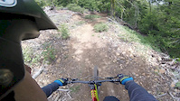
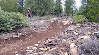
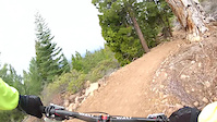
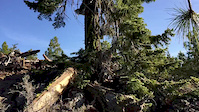
Photos of Spence Mountain Mountain Bike
Videos of Spence Mountain Mountain Bike
trail: North Ridge
3:55 |
1264 |
Jun 11, 2017
trail: Spence Mt South Ridge
0:12 |
341 |
Apr 26, 2016
trail: Spence Mt South Ridge
13:00 |
648 |
Apr 11, 2015
trail: Spence Mt South Ridge
0:23 |
352 |
Mar 8, 2015
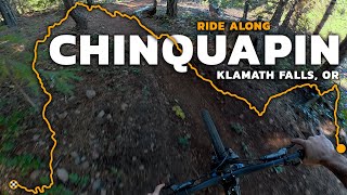
trail: Chinquapin
7:22 |
16 |
May 29, 2026 , Klamath Falls
youtuber
![The BEST Blue Flow Trail In Oregon? Chinquapin...]()
trail: Chinquapin
8:15 |
94 |
Jan 7, 2026 , Klamath Falls
trail: North Ridge
6:08 |
83 |
Dec 15, 2025 , Klamath Falls

Recent Trail Reports
| status | trail | date | condition | info | user |
|---|---|---|---|---|---|
| Peak Tie | Jun 5, 2026 @ 3:15pm (America/Los_Angeles) Jun 5, 2026 | Dry | everettw | ||
| Queen of the Lake | May 29, 2026 @ 5:23pm (America/Los_Angeles) May 29, 2026 | Ideal | Dang3 | ||
| North Ridge | May 28, 2026 @ 6:52pm (America/Los_Angeles) May 28, 2026 | Dry | kwietrick | ||
| Old Eagle | May 25, 2026 @ 12:53pm (America/Boise) May 25, 2026 | Ideal | RsinFyter | ||
| IMBA Trail | May 25, 2026 @ 11:02am (America/Los_Angeles) May 25, 2026 | Dry | Jasoncoatney | ||
| Spence Mt South Ridge | May 25, 2026 @ 11:02am (America/Los_Angeles) May 25, 2026 | Dry | Jasoncoatney | ||
| Chinquapin | May 19, 2026 @ 2:09pm (America/Los_Angeles) May 19, 2026 | Dry | everettw | ||
| Queen of the Lake | May 16, 2026 @ 1:58pm (America/Los_Angeles) May 16, 2026 | Unknown | AlexE8SKSv | ||
| Eagle Ridge | May 12, 2026 @ 5:53pm (America/Los_Angeles) May 12, 2026 | Unknown | concretekahuna | ||
| Upper Hooligan | May 3, 2026 @ 7:01pm (America/Los_Angeles) May 3, 2026 | Dry | everettw |
Activity Feed
| username | action | type | title | date |
|---|---|---|---|---|
| ws2158 | vote | route | activity #97143313 | Jun 16, 2026 @ 3:58pm 2 days |
| ws2158 | ridden | route | activity #97143308 | Jun 16, 2026 @ 3:58pm 2 days |
| mgoodm3 | add | trail | activity #97135276 and 5 more | Jun 16, 2026 @ 1:36pm 2 days |
| Ckareth | wishlist | trail | activity #96412029 | Jun 6, 2026 @ 3:48pm Jun 6, 2026 |
| Bigswishy | wishlist | trail | activity #96375678 | Jun 6, 2026 @ 8:46am Jun 6, 2026 |
Recent Comments
| username | type | title | comment | date |
|---|---|---|---|---|
| trail | great trail system. lots of green-blue tech... | Jun 2, 2026 @ 8:31pm Jun 2, 2026 | ||
| trail | I'm | May 29, 2026 @ 9:28pm May 29, 2026 | ||
| trail | Dirt Mechanics strike again. More fun than a... | May 25, 2026 @ 9:00pm May 25, 2026 | ||
| trail | Do not skip this one! An absolute must-do add... | May 25, 2026 @ 8:59pm May 25, 2026 | ||
| trail | Might be one of the best trails in Oregon.... | May 25, 2026 @ 12:02pm May 25, 2026 |
Nearby Areas
| name | distance | ||||
|---|---|---|---|---|---|
| Moore Mountain | 29 | 28 | 9 | 3 | 13 km |
| Hogsback | 1 | 16.9 km | |||
| Brown Mountain | 12 | 5 | 17 km | ||
| Keno | 3 | 2 | 20.3 km |
Local Badges
-

Completionist2 awarded
Activity Type Stats
| activitytype | trails | distance | descent | descent distance | total vertical | rating | global rank | state rank | photos | reports | routes | ridelogs |
|---|---|---|---|---|---|---|---|---|---|---|---|---|
| Mountain Bike | 54 | 53 miles | 8,392 ft | 24 miles | 1,696 ft | #2,294 | #785 | 142 | 542 | 14 | 4,961 | |
| E-Bike | 54 | 15 miles | 2,018 ft | 5 miles | 1,673 ft | #617 | #602 | 476 | 451 | |||
| Adaptive Bike | 1 | #2,281 | #1,164 | |||||||||
| Hike | 49 | 47 miles | 5,489 ft | 18 miles | 1,696 ft | #4,608 | 1 | 516 | 2 | 94 | ||
| Trail Running | 50 | 47 miles | 5,489 ft | 18 miles | 1,696 ft | #3,783 | #1,050 | 521 | 2 | 60 |
Frequently Asked Questions About Spence Mountain
▼
What are the highest rated mountain biking trails in Spence Mountain?
The highest rated mountain biking trails in Spence Mountain are:
- Nighthawk (4.4/5)
- North Ridge (4.4/5)
- Spence Mt South Ridge (4.4/5)
- Chinquapin (4.3/5)
- Speed King (4.3/5)
▼
What is the best time of the year to ride in Spence Mountain?
Based on ride log data, the most popular months to ride in Spence Mountain are:
- July (71 activities)
- May (66 activities)
- June (52 activities)
▼
Where can I park to ride in Spence Mountain?
There are 2 parking locations listed in Spence Mountain. The most popular parking spots are:
▼
What is the longest trail in Spence Mountain?
The longest trail in Spence Mountain is Spence Peak at 5.6 miles. View all trails sorted by distance.
Activities
Trails
Points of Interest
- By kevin11jones
 & contributors
 - Admins: KTA
- #7515 - 26,976 views
- spence mountain activity log | embed map of Spence Mountain mountain bike trails | spence mountain mountain biking points of interest
Downloading of trail gps tracks in kml & gpx formats is enabled for Spence Mountain.
You must login to download files.