close
-
Layers w
- Weather Layers
- Pro
- Pro
- Pro
- Pro
- Pro
- Pro
- More Layers
- Pro
- Pro
- Pro
- Pro
-
Upgrade to

3D
Trail Conditions
- Unknown
- Snow Groomed
- Snow Packed
- Snow Covered
- Snow Cover Partial
- Freeze/thaw Cycle
- Icy
- Prevalent Mud
- Wet
- Variable
- Ideal
- Dry
- Very Dry
Trail Flow (Ridden Direction)
Trailforks scans users ridelogs to determine the most popular direction each trail is ridden. A good flowing trail network will have most trails flowing in a single direction according to their intension.
The colour categories are based on what percentage of riders are riding a trail in its intended direction.
The colour categories are based on what percentage of riders are riding a trail in its intended direction.
- > 96%
- > 90%
- > 80%
- > 70%
- > 50%
- < 50%
- bi-directional trail
- no data
Trail Last Ridden
Trailforks scans ridelogs to determine the last time a trail was ridden.
- < 2 days
- < 1 week
- < 2 weeks
- < 1 month
- < 6 months
- > 6 months
Trail Ridden Direction
The intended direction a trail should be ridden.
- Downhill Only
- Downhill Primary
- Both Directions
- Uphill Primary
- Uphill Only
- One Direction
Contribute Details
Colors indicate trail is missing specified detail.
- Description
- Photos
- Description & Photos
- Videos
Trail Popularity ?
Trailforks scans ridelogs to determine which trails are ridden the most in the last 9 months.
Trails are compared with nearby trails in the same city region with a possible 25 colour shades.
Think of this as a heatmap, more rides = more kinetic energy = warmer colors.
- most popular
- popular
- less popular
- not popular
ATV/ORV/OHV Filter
Max Vehicle Width
inches
US Cell Coverage
Legend

Radar Time
Activity Recordings
Trailforks uses anonymized public activity data.
?
Activity Recordings
Trailforks uses anonymized public activity data.
?
Personal Heatmap
▶
Activity Types
all
/
none
▶
Options
2
Date range
month
–
Winter Trails
Warning
A routing network for winter maps does not exist. Selecting trails using the winter trails layer has been disabled.
Missing Trails
Most Popular
Least Popular
Trails are colored based on popularity. The more popular a trail is, the more red. Less popular trails trend towards green.
Jump Magnitude Heatmap
Heatmap of where riders jump on trails. Zoom in to see individual jumps, click circles to view jump details.
BC Backroad Status
![map legend]()
Service Road Atlas is a free to use, community-driven service for viewing and creating reports on the numerous back-country service roads around B.C. and Alberta.

Slope Aspect
Direction the slope faces
Trails Deemphasized
Trails are shown in grey.
Only show trails with no bike usage.
Suggested Layers
Based on selected activity type
Save the current map location and zoom level as your default home location whenever this page is loaded.
Save
No description for Spring Creek has been added yet!
Login or register to submit one.
 google parking directions
Primary Trail Type: All-Mountain & Downhill
Shuttleable: YES
google parking directions Activities Click to view
- Mountain Bike
41 trails
- E-Bike
19 trails
- Horse
16 trails
- Hike
41 trails
- Trail Running
41 trails
- Dirtbike/Moto
20 trails
- ATV/ORV/OHV
5 trails
- Snowshoe
4 trails
Region Details
- 18
- 2
- 9
- 10
Region Status
Open as of Jun 15, 2026Stats
- Avg Trail Rating
- Trails (view details)
- 39
- Trails Mountain Bike
- 41
- Trails E-Bike
- 19
- Trails Gravel Bike
- 1
- Trails Adaptive Bike
- 1
- Trails Horse
- 16
- Trails Hike
- 41
- Trails Trail Running
- 41
- Trails Dirtbike/Moto
- 20
- Trails ATV/ORV/OHV
- 5
- Trails Snowmobile
- 3
- Trails Snowshoe
- 4
- Total Distance
- 123 miles
- Total Descent
- 17,737 ft
- Total Vertical
- 3,493 ft
- Highest Trailhead
- 11,832 ft
- Reports
- 482
- Photos
- 130
- Ridden Counter
- 7,782
Popular Spring Creek Mountain Biking Trails
• 100 ★ 4.7 • 7 miles • 241 ft • 2,263 •
(CR744) and countless reports of speeding, homeowners are becoming unhappy with the situation. Please be respectful of homeowners and your fellow riders whom ride the full loop. Riders don't want to choke on your dust as you go speeding...
• 60 ★ 4.0 • 2 miles • 210 ft • 302 •
Most of the trail is easy. It traverses a big meadow and just rolls. The north east section has some rocky sections to either climb up, or descend. Does offer some good views if you can manage to avoid the cow pies everywhere.
• 75 ★ 3.0 • 1,322 ft • 0 ft • 269 •
Easy access trail to the condos at San Moritz. Pretty flat, with really only one little rocky turn. Links you right up to Lower
• 45 ★ 3.0 • 3 miles • 0 ft • 123 •
Rosebud acts as a great connector to make new loops with the trails between Cement Creek and Spring Creek Road. The trail is usually very loose with lots of babyheads present on the trail. As a loop with Reno, Flag, and Bear Creek,...
• 45 ★ 2.5 • 2 miles • 390 ft • 99 •
Fun trail that flows pretty good with some good size rocks and rooty sections
• 50 ★ 3.5 • 6 miles • 1,365 ft • 92 •
This is a fun trail that has some technical steep sections and loose rock, but it can be fast too on the flats and flowying sections.
• 45 ★ 3.0 • 5 miles • 702 ft • 83 •
Eccher Gulch sometimes described as a "locals favorite". Maybe because its not crawling with visitors like the extremely popular 401 or Teocalli Ridge trails. Because the remote nature of the trail, its often overgrown thus may be...
• 40 ★ 0.0 • 7 miles • 1,748 ft • 30 • • moto
This is a washed out moto trail. If you ride the Doctor Gulch Bonus you may see some moto track heading up towards it. Pretty much nobody rides it on a bike. There are sections that turn to ATV style double track, but it is mostly...
Spring Creek Mountain Bike Routes
★ 4.0 • 19 miles • 2,686 ft • 4 •
★ 4.0 • 7 miles • 241 ft • 1 • Point to Point •
Doctor Park is located in Taylor Canyon, and accessed via a dirt road climb that some people will opt to...
★ 5.0 • 28 miles • 4,073 ft • 8 • Shuttled •
This route combines three of the best downhill trails in the Spring Creek area resulting in a highly...
★ 5.0 • 29 miles • 4,156 ft • 25 • Point to Point •
2017 YETI Tribe Group Ride - Full Route
50 miles • 8,876 ft • 9 •
14 miles • 3,001 ft • 1 •
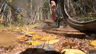
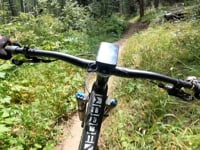
Photos of Spring Creek Mountain Bike
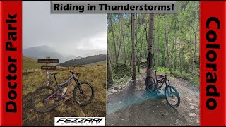
Videos of Spring Creek Mountain Bike
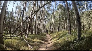
trail: Dr. Park
23:09 |
172 |
May 6, 2024 , Crested Butte
trail: Dr. Park
4:05 |
104 |
Oct 12, 2023 , Crested Butte

youtuber
![The amazing Doctor Park Trail in a...]()
trail: Dr. Park Bonus
23:44 |
139 |
Sep 12, 2023 , Crested Butte
youtuber
![The amazing Doctor Park Trail in a...]()

trail: Doctor Gulch Road
23:44 |
170 |
Sep 12, 2023 , Crested Butte

trail: Dr. Park
4:48 |
188 |
Dec 18, 2021 , Crested Butte

Recent Trail Reports
| status | trail | date | condition | info | user |
|---|---|---|---|---|---|
| Dr. Park | Jun 15, 2026 @ 10:23am (America/Denver) Jun 15, 2026 | Dry | aestike | ||
| San Moritz | Aug 30, 2025 @ 6:00am Aug 30, 2025 | Variable | jacobdko | ||
| Walrod Road | Jul 31, 2024 @ 1:25pm Jul 31, 2024 | Variable | markholloway Trailforks | ||
| Star | Jul 31, 2024 @ 1:25pm Jul 31, 2024 | Variable | markholloway Trailforks | ||
| Rosebud Gulch | Jul 31, 2024 @ 1:25pm Jul 31, 2024 | Variable | markholloway Trailforks | ||
| Rocky Brook Road | Jul 31, 2024 @ 1:25pm Jul 31, 2024 | Variable | markholloway Trailforks | ||
| Rocky Brook - Dr Park Connector | Jul 31, 2024 @ 1:25pm Jul 31, 2024 | Variable | markholloway Trailforks | ||
| Roaring Judy Rd. | Jul 31, 2024 @ 1:25pm Jul 31, 2024 | Variable | markholloway Trailforks | ||
| Roaring Judy | Jul 31, 2024 @ 1:25pm Jul 31, 2024 | Variable | markholloway Trailforks | ||
| Powder Cache Rd. | Jul 31, 2024 @ 1:25pm Jul 31, 2024 | Variable | markholloway Trailforks |
Activity Feed
| username | action | type | title | date |
|---|---|---|---|---|
| bcrobbins | wishlist | route | activity #97305258 and 1 more | Jun 19, 2026 @ 3:13am 17 hours |
| Berminatorr | ridden | trail | activity #97175404 | Jun 17, 2026 @ 5:13am 3 days |
| alexrrowe | wishlist | route | activity #97139542 | Jun 16, 2026 @ 2:57pm Jun 16, 2026 |
| 1989ebikes | comment | trail | activity #97122239 | Jun 16, 2026 @ 10:39am Jun 16, 2026 |
| dave-cbmba | update | trail | activity #97107116 | Jun 16, 2026 @ 7:03am Jun 16, 2026 |
Recent Comments
| username | type | title | comment | date |
|---|---|---|---|---|
| trail | why not open this to e-bikes if you don't want... | Jun 16, 2026 @ 10:39am Jun 16, 2026 | ||
| trail | how about STFU? | May 30, 2026 @ 6:07pm May 30, 2026 | ||
| trail | settle down big guy | May 12, 2026 @ 9:42am May 12, 2026 | ||
| trail | From my understanding, this FS road is prone... | Oct 21, 2025 @ 9:48am Oct 21, 2025 | ||
| trail | 100% shuttle this. Despite what you read in... | Oct 14, 2025 @ 1:13pm Oct 14, 2025 |
Nearby Areas
| name | distance | ||||
|---|---|---|---|---|---|
| Cement Creek | 1 | 10 | 14 | 4.8 km | |
| Brush Creek | 8 | 10 | 9.4 km | ||
| Crested Butte Mountain Bike Park | 11 | 13 | 7 | 3 | 11.9 km |
| Crested Butte Town Trails | 12 | 8 | 9 | 13 km | |
| Signal Peak | 8 | 12 | 1 | 16.7 km |
Local Badges
-

Completionist0 awarded
Local Products
Activity Type Stats
| activitytype | trails | distance | descent | descent distance | total vertical | rating | global rank | state rank | photos | reports | routes | ridelogs |
|---|---|---|---|---|---|---|---|---|---|---|---|---|
| Mountain Bike | 41 | 123 miles | 17,736 ft | 43 miles | 3,494 ft | #2,441 | #845 | 143 | 482 | 20 | 5,476 | |
| E-Bike | 19 | 60 miles | 4,993 ft | 15 miles | 3,481 ft | #2,701 | #867 | 442 | 199 | |||
| Gravel Bike | 1 | #1,807 | #953 | 1 | 6 | |||||||
| Adaptive Bike | 1 | #1,812 | #955 | |||||||||
| Horse | 16 | 68 miles | 5,968 ft | 18 miles | 3,494 ft | #802 | #423 | 65 | ||||
| Hike | 41 | 123 miles | 17,736 ft | 43 miles | 3,494 ft | #1,673 | #735 | 483 | 12 | 137 | ||
| Trail Running | 41 | 123 miles | 17,736 ft | 43 miles | 3,494 ft | #1,076 | #332 | 483 | 12 | 115 | ||
| Dirtbike/Moto | 20 | 54 miles | 6,982 ft | 20 miles | 2,477 ft | #571 | #174 | 122 | 12 | |||
| ATV/ORV/OHV | 5 | 19 miles | 974 ft | 6 miles | 1,447 ft | #635 | #290 | 56 | ||||
| Snowmobile | 3 | 15 miles | 961 ft | 6 miles | 1,286 ft | 1 | ||||||
| Snowshoe | 4 | 17 miles | 968 ft | 6 miles | 1,286 ft | #996 | #489 | 9 |
Frequently Asked Questions About Spring Creek
▼
What are the highest rated mountain biking trails in Spring Creek?
The highest rated mountain biking trails in Spring Creek are:
- Dr. Park (4.6/5)
- Dr. Park Bonus (4/5)
- Timberline (Sec 4) (4/5)
- Cement Mountain/Julie Andrews (3.9/5)
- Gunnison Spur - Dr. Park (3.9/5)
▼
What is the best time of the year to ride in Spring Creek?
Based on ride log data, the most popular months to ride in Spring Creek are:
- July (148 activities)
- September (77 activities)
- August (73 activities)
▼
Where can I park to ride in Spring Creek?
There are 8 parking locations listed in Spring Creek. The most popular parking spots are: View all parking and trailhead locations on the map to plan your visit.
▼
What is the longest trail in Spring Creek?
The longest trail in Spring Creek is Gunnison Spur - Dr. Park at 9.0 miles. View all trails sorted by distance.
Activities
Trails
- By BigMtnEnduro
 & contributors
 - Admins: CBMBA, BigMtnEnduro, dave-cbmba, teocalliridge, CBMtnBike
- #9261 - 5,643 views
- spring creek activity log | embed map of Spring Creek mountain bike trails | spring creek mountain biking points of interest polygons
Downloading of trail gps tracks in kml & gpx formats is enabled for Spring Creek.
You must login to download files.