close
-
Layers w
- Weather Layers
- Pro
- Pro
- Pro
- Pro
- Pro
- Pro
- More Layers
- Pro
- Pro
- Pro
- Pro
-
Upgrade to

3D
Trail Conditions
- Unknown
- Snow Groomed
- Snow Packed
- Snow Covered
- Snow Cover Partial
- Freeze/thaw Cycle
- Icy
- Prevalent Mud
- Wet
- Variable
- Ideal
- Dry
- Very Dry
Trail Flow (Ridden Direction)
Trailforks scans users ridelogs to determine the most popular direction each trail is ridden. A good flowing trail network will have most trails flowing in a single direction according to their intension.
The colour categories are based on what percentage of riders are riding a trail in its intended direction.
The colour categories are based on what percentage of riders are riding a trail in its intended direction.
- > 96%
- > 90%
- > 80%
- > 70%
- > 50%
- < 50%
- bi-directional trail
- no data
Trail Last Ridden
Trailforks scans ridelogs to determine the last time a trail was ridden.
- < 2 days
- < 1 week
- < 2 weeks
- < 1 month
- < 6 months
- > 6 months
Trail Ridden Direction
The intended direction a trail should be ridden.
- Downhill Only
- Downhill Primary
- Both Directions
- Uphill Primary
- Uphill Only
- One Direction
Contribute Details
Colors indicate trail is missing specified detail.
- Description
- Photos
- Description & Photos
- Videos
Trail Popularity ?
Trailforks scans ridelogs to determine which trails are ridden the most in the last 9 months.
Trails are compared with nearby trails in the same city region with a possible 25 colour shades.
Think of this as a heatmap, more rides = more kinetic energy = warmer colors.
- most popular
- popular
- less popular
- not popular
ATV/ORV/OHV Filter
Max Vehicle Width
inches
US Cell Coverage
Legend

Radar Time
Activity Recordings
Trailforks uses anonymized public activity data.
?
Activity Recordings
Trailforks uses anonymized public activity data.
?
Personal Heatmap
▶
Activity Types
all
/
none
▶
Options
2
Date range
month
–
Winter Trails
Warning
A routing network for winter maps does not exist. Selecting trails using the winter trails layer has been disabled.
Missing Trails
Most Popular
Least Popular
Trails are colored based on popularity. The more popular a trail is, the more red. Less popular trails trend towards green.
Jump Magnitude Heatmap
Heatmap of where riders jump on trails. Zoom in to see individual jumps, click circles to view jump details.
BC Backroad Status
![map legend]()
Service Road Atlas is a free to use, community-driven service for viewing and creating reports on the numerous back-country service roads around B.C. and Alberta.

Slope Aspect
Direction the slope faces
Trails Deemphasized
Trails are shown in grey.
Only show trails with no bike usage.
Suggested Layers
Based on selected activity type
Save the current map location and zoom level as your default home location whenever this page is loaded.
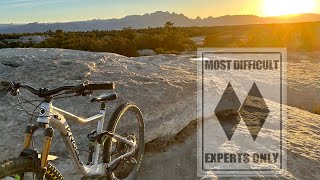
SaveLarge Hill on the NNW side of town. Has several radio towers.
Primary Trail Type: All-Mountain & Downhill
Shuttleable: YES
 google parking directions
 Activities Click to view
- Mountain Bike
9 trails
- E-Bike
6 trails
- Hike
9 trails
- Trail Running
9 trails
Region Details
- 6
- 2
- 1
Region Status
Open as of Sep 22, 2024Local Trail Association
Stats
- Avg Trail Rating
- Trails (view details)
- 9
- Trails Mountain Bike
- 9
- Trails E-Bike
- 6
- Trails Horse
- 1
- Trails Hike
- 9
- Trails Trail Running
- 9
- Trails Dirtbike/Moto
- 1
- Trails Observed Trials
- 1
- Trails ATV/ORV/OHV
- 2
- Total Distance
- 14 miles
- Total Descent Distance
- 6 miles
- Total Descent
- 3,454 ft
- Total Vertical
- 1,667 ft
- Highest Trailhead
- 7,969 ft
- Reports
- 38
- Photos
- 22
- Ridden Counter
- 528
Popular Squaw Peak Mountain Biking Trails
• 75 ★ 4.5 • 2 miles • 22 ft • 160 •
Downhill run on from Squaw Peak. Starts out a little flat, but the end more than makes up for it.
• 60 ★ 5.0 • 3,028 ft • 0 ft • 35 •
A steep and loose descent with lots of rock rollers, drops, and very steep lines
Squaw Peak Mountain Bike Routes
4 miles • 1,131 ft • 2 •
Make sure the intersection for and Squaw climb is marked clearly.
5 miles • 1,044 ft • 3 •
Make sure the intersection for and the Squaw climb is clearly marked.
• 2 miles • 67 ft • 1 •
• 6 miles • 1,689 ft • 2 •
• 2 miles • 771 ft • 1 •
Photos of Squaw Peak Mountain Bike
Videos of Squaw Peak Mountain Bike

trail: Rob's Knob
2:49 |
165 |
Jul 26, 2024 , Ely
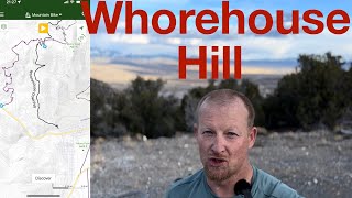
trail: Whorehouse Downhill
10:05 |
312 |
Apr 29, 2024 , Ely
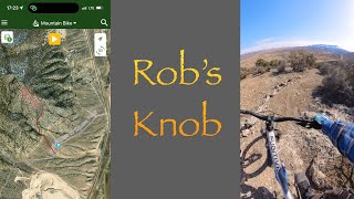
trail: Rob's Knob
3:54 |
186 |
Apr 5, 2024 , Ely

trail: Whorehouse Downhill
8:04 |
250 |
May 12, 2023 , Ely
trail: Rob's Knob
8:04 |
153 |
May 12, 2023 , Ely
trail: Whorehouse Downhill
21:16 |
230 |
Oct 3, 2022 , Ely

trail: Whorehouse Downhill
43:56 |
259 |
Jun 16, 2022 , Ely

trail: Rob's Knob
43:56 |
156 |
Jun 16, 2022 , Ely
Recent Trail Reports
| status | trail | date | condition | info | user |
|---|---|---|---|---|---|
| Squaw Peak Traverse | Nov 15, 2023 @ 7:20pm Nov 15, 2023 | Variable | Paorton | ||
| Squaw Peak Climb | Nov 15, 2023 @ 7:20pm Nov 15, 2023 | Variable | Paorton | ||
| Rob's Knob | Nov 15, 2023 @ 7:20pm Nov 15, 2023 | Variable | Paorton | ||
| K2 Rob's Knob Connector | Nov 15, 2023 @ 7:20pm Nov 15, 2023 | Variable | Paorton | ||
| East Knob OHV | Nov 15, 2023 @ 7:20pm Nov 15, 2023 | Variable | Paorton | ||
| East Access to Squaw Peak | Nov 15, 2023 @ 7:20pm Nov 15, 2023 | Variable | Paorton | ||
| K2 | Sep 30, 2023 @ 7:14am Sep 30, 2023 | Dry | Paorton |
Activity Feed
| username | action | type | title | date |
|---|---|---|---|---|
| kelernest | update | trail | activity #93183881 | Apr 22, 2026 @ 5:28pm Apr 22, 2026 |
| XyukonR | wishlist | trail | activity #92999349 | Apr 19, 2026 @ 8:15pm Apr 19, 2026 |
| kelernest | update | trail | activity #92597537 and 2 more | Apr 14, 2026 @ 8:00am Apr 14, 2026 |
| ZacharyjwPZQp | wishlist | trail | activity #92141009 | Apr 7, 2026 @ 2:17pm Apr 7, 2026 |
| chainslapAZ | vote | trail | activity #84221005 | Nov 15, 2025 @ 8:05pm Nov 15, 2025 |
Recent Comments
| username | type | title | comment | date |
|---|---|---|---|---|
| trail | While we were staying in Ely for the night, we... | Apr 28, 2024 @ 9:05pm Apr 28, 2024 | ||
| trail | This was a great trail to ride during an over... | Apr 19, 2024 @ 9:23pm Apr 19, 2024 | ||
| trail | Don’t bother. Great view from the top but... | May 14, 2023 @ 11:45am May 14, 2023 | ||
| trail | Was not worth the drive up, shaley and lose,... | May 14, 2023 @ 11:15am May 14, 2023 | ||
| trail | The best, gnarliest trail in Ely! Raw, loose,... | Nov 28, 2022 @ 3:03pm Nov 28, 2022 |
Nearby Areas
| name | distance | ||||
|---|---|---|---|---|---|
| Ward Mountain | 25 | 8 | 1 | 1 | 4.8 km |
| Cave Lake State Park | 3 | 6 | 12.6 km | ||
| Ward Charcoal Ovens State Park | 4 | 3 | 16 km | ||
| Northern Schell Creek Range | 28.8 km |
Local Mountain Biking Directory
-
SportsWorld
-
Great Basin Trails StewardshipTrail Association
![Great Basin Trails Stewardship]()
Activity Type Stats
| activitytype | trails | distance | descent | descent distance | total vertical | rating | global rank | state rank | photos | reports | routes | ridelogs |
|---|---|---|---|---|---|---|---|---|---|---|---|---|
| Mountain Bike | 9 | 14 miles | 3,455 ft | 6 miles | 1,667 ft | #7,442 | #2,861 | 22 | 38 | 3 | 819 | |
| E-Bike | 6 | 9 miles | 1,302 ft | 3 miles | 1,657 ft | #7,351 | #2,149 | 32 | 45 | |||
| Horse | 1 | 4,465 ft | 230 ft | 2,759 ft | 180 ft | 9 | ||||||
| Hike | 9 | 14 miles | 3,455 ft | 6 miles | 1,667 ft | #11,086 | #4,440 | 38 | 31 | |||
| Trail Running | 9 | 14 miles | 3,455 ft | 6 miles | 1,667 ft | #10,186 | #3,769 | 38 | 1 | |||
| Dirtbike/Moto | 1 | 4,465 ft | 230 ft | 2,759 ft | 180 ft | 9 | ||||||
| Observed Trials | 1 | 4,465 ft | 230 ft | 2,759 ft | 180 ft | |||||||
| ATV/ORV/OHV | 2 | 2 miles | 302 ft | 3,973 ft | 361 ft | 9 |
Frequently Asked Questions About Squaw Peak
▼
What are the highest rated mountain biking trails in Squaw Peak?
The highest rated mountain biking trails in Squaw Peak are:
- Whorehouse Downhill (4.3/5)
- Rob's Knob (4.1/5)
- K2 (0/5)
▼
What is the best time of the year to ride in Squaw Peak?
Based on ride log data, the most popular months to ride in Squaw Peak are:
- August (4 activities)
- June (4 activities)
- December (4 activities)
▼
Where can I park to ride in Squaw Peak?
There are 4 parking locations listed in Squaw Peak. The most popular parking spots are: View all parking and trailhead locations on the map to plan your visit.
▼
What is the longest trail in Squaw Peak?
The longest trail in Squaw Peak is Whorehouse Downhill at 3.5 km. View all trails sorted by distance.
Activities
- By winterismyseason
 & contributors
 - Admins: GBTS
- #3396 - 3,951 views
- squaw peak activity log | embed map of Squaw Peak mountain bike trails | squaw peak mountain biking points of interest
Downloading of trail gps tracks in kml & gpx formats is enabled for Squaw Peak.
You must login to download files.