close
-
Layers w
- Weather Layers
- Pro
- Pro
- Pro
- Pro
- Pro
- Pro
- More Layers
- Pro
- Pro
- Pro
- Pro
-
Upgrade to

3D
Trail Conditions
- Unknown
- Snow Groomed
- Snow Packed
- Snow Covered
- Snow Cover Partial
- Freeze/thaw Cycle
- Icy
- Prevalent Mud
- Wet
- Variable
- Ideal
- Dry
- Very Dry
Trail Flow (Ridden Direction)
Trailforks scans users ridelogs to determine the most popular direction each trail is ridden. A good flowing trail network will have most trails flowing in a single direction according to their intension.
The colour categories are based on what percentage of riders are riding a trail in its intended direction.
The colour categories are based on what percentage of riders are riding a trail in its intended direction.
- > 96%
- > 90%
- > 80%
- > 70%
- > 50%
- < 50%
- bi-directional trail
- no data
Trail Last Ridden
Trailforks scans ridelogs to determine the last time a trail was ridden.
- < 2 days
- < 1 week
- < 2 weeks
- < 1 month
- < 6 months
- > 6 months
Trail Ridden Direction
The intended direction a trail should be ridden.
- Downhill Only
- Downhill Primary
- Both Directions
- Uphill Primary
- Uphill Only
- One Direction
Contribute Details
Colors indicate trail is missing specified detail.
- Description
- Photos
- Description & Photos
- Videos
Trail Popularity ?
Trailforks scans ridelogs to determine which trails are ridden the most in the last 9 months.
Trails are compared with nearby trails in the same city region with a possible 25 colour shades.
Think of this as a heatmap, more rides = more kinetic energy = warmer colors.
- most popular
- popular
- less popular
- not popular
ATV/ORV/OHV Filter
Max Vehicle Width
inches
US Cell Coverage
Legend

Radar Time
Activity Recordings
Trailforks uses anonymized public activity data.
?
Activity Recordings
Trailforks uses anonymized public activity data.
?
Personal Heatmap
▶
Activity Types
all
/
none
▶
Options
2
Date range
month
–
Winter Trails
Warning
A routing network for winter maps does not exist. Selecting trails using the winter trails layer has been disabled.
Missing Trails
Most Popular
Least Popular
Trails are colored based on popularity. The more popular a trail is, the more red. Less popular trails trend towards green.
Jump Magnitude Heatmap
Heatmap of where riders jump on trails. Zoom in to see individual jumps, click circles to view jump details.
BC Backroad Status
![map legend]()
Service Road Atlas is a free to use, community-driven service for viewing and creating reports on the numerous back-country service roads around B.C. and Alberta.

Slope Aspect
Direction the slope faces
Trails Deemphasized
Trails are shown in grey.
Only show trails with no bike usage.
Suggested Layers
Based on selected activity type
Save the current map location and zoom level as your default home location whenever this page is loaded.
Save
No description for St. Joseph has been added yet!
Login or register to submit one.
AKA: Saint Joseph
Activities Click to view
- Mountain Bike
103 trails
- E-Bike
104 trails
- Gravel Bike
0 trails
- Adaptive Bike
0 trails
- Winter Fat Bike
0 trails
- Hike
70 trails
- Trail Running
67 trails
- Dirtbike/Moto
10 trails
Region Details
- 21
- 42
- 20
- 14
- 5
Region Status
Open as of Jun 19, 2026Stats
- Avg Trail Rating
- Trails (view details)
- 102
- Trails Mountain Bike
- 106
- Trails E-Bike
- 104
- Trails Hike
- 70
- Trails Trail Running
- 67
- Trails Dirtbike/Moto
- 10
- Total Distance
- 64 miles
- Total Descent Distance
- 27 miles
- Total Descent
- 7,510 ft
- Total Vertical
- 326 ft
- Highest Trailhead
- 1,135 ft
- Reports
- 138
- Photos
- 50
- Ridden Counter
- 6,594
Sub Regions
-
Krug Park
- 1
- 1
-
Lower 4
- 2
-
River Bluff Trails Park
- 28
- 13
- 10
- 4
-
Sunbridge River Bluffs
- 10
- 4
- 2
- 1
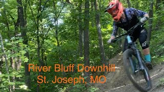
Popular St. Joseph Mountain Biking Trails
• 100 ★ 4.7 • 1,014 ft • 0 ft • 224 •
starts at the to the left of St. Flow. Riders can experience a variety of tabletops that can be easily rolled by beginners. Large sweeping berms give generous room for aMTB riders and give beginners an opportunity to learn how to ride...
• 100 ★ 5.0 • 1,132 ft • 0 ft • 209 •
is a great little trail for beginners to work on technical skills and line choice. The trail begins at the and follows a heavily eroded legacy trail. As it twists and turns, there are several corners that riders can use the walls of the...
• 100 ★ 5.0 • 928 ft • 0 ft • 180 •
St. Flow is a DH only trail in the middle of the Beginner Flow Zone of River Bluffs Trails Park. It begins at the Flow Zone hub on the to the right of . Some small banked turns lead to a sweeping left hand turn where the start of...
• 90 ★ 3.5 • 1,739 ft • 0 ft • 175 •
This is the primary downhill trail at the main trailhead of the park. It starts beside , an intermediate jump line on the left. was designed and built to consider the width, geometry, and unique handling characteristics of adaptive...
• 100 ★ 5.0 • 502 ft • 0 ft • 165 •
is an optional line off of . It is a flow/jump trail that is downhill only. It starts with a slight climb that sets rider up for the fun to come. The first feature is a jump that is hipped to the left giving one some flirtation with a...
• 95 ★ 4.4 • 522 ft • 0 ft • 163 •
begins at the hub near the WPA structures with . Before the descent begins, branches off to the left. Continuing straight leads to the first feature which is an easy intermediate drop. The trail flows across half pipe style terrain into...
• 100 ★ 5.0 • 1,001 ft • 0 ft • 157 •
begins with but goes right at the split. It's fairly flat at the beginning but riders should have plenty of speed from entering the trail from Goat or the . The trail begins to descend with a few jumps and banked turns before it returns...
• 95 ★ 0.0 • 1,631 ft • 3 ft • 152 •
begins at the south end of the . It crosses the shortly thereafter. The start of is just after the crossing branching to the right. Go left to continue on . The trail descends and offers some rollers that experienced riders can get a...
St. Joseph Mountain Bike Routes
1 mile • 181 ft • 0 • Loop •
The All-Weather Loop is a group of segments from different trails that are covered with gravel. This loop,...
8 miles • 970 ft • 15 • Race •
This is the route for River Bluffs Bike Fest Enduro Jam, where you ride the 4 stages as many times as you...
11 miles • 2,063 ft • 17 • Race •
This is a rough map of the St Joe Enduro course, run by Pro/Expert and E-Bike riders for 7 stages. The...
5 miles • 443 ft • 5 • Race •
The XC race course, this year, will run clockwise. The main difference over last year's course is that the...
Photos of St. Joseph Mountain Bike
Videos of St. Joseph Mountain Bike
trail: Space Jam
4:22 |
844 |
Jul 4, 2022 , St. Joseph
Current Trail Warnings
| status | trail | date | condition | user | info |
|---|---|---|---|---|---|
| Ski School | May 29, 2026 @ 4:59pm (America/Chicago) May 29, 2026 | Prevalent Mud | falcon013 |
Recent Trail Reports
| status | trail | date | condition | info | user |
|---|---|---|---|---|---|
| Root Chute | May 29, 2026 @ 4:59pm (America/Chicago) May 29, 2026 | Variable | falcon013 | ||
| Space Jam | May 29, 2026 @ 4:59pm (America/Chicago) May 29, 2026 | Variable | falcon013 | ||
| Roly Poly | May 29, 2026 @ 4:59pm (America/Chicago) May 29, 2026 | Variable | falcon013 | ||
| Jekyll & Hyde | May 29, 2026 @ 4:59pm (America/Chicago) May 29, 2026 | Variable | falcon013 | ||
| Splish Splash | May 29, 2026 @ 4:59pm (America/Chicago) May 29, 2026 | Variable | falcon013 | ||
| Mounds | May 2, 2026 @ 1:59pm (America/Chicago) May 2, 2026 | Ideal | Eric1rYbMJ | ||
| Lanowa | Mar 28, 2026 @ 9:29pm (America/Chicago) Mar 28, 2026 | Dry | bkbettis | ||
| Krug Park | Oct 6, 2025 @ 9:38pm (America/Chicago) Oct 6, 2025 | Unknown | JeremeK8tfRs | ||
| North Loop | Sep 28, 2025 @ 6:29pm (America/Chicago) Sep 28, 2025 | Ideal | bkbettis | ||
| Nomad Short Loop Connector | Sep 28, 2025 @ 6:29pm (America/Chicago) Sep 28, 2025 | Ideal | bkbettis |
Activity Feed
| username | action | type | title | date |
|---|---|---|---|---|
| NathanKen | ridden | trail | activity #97353308 | Jun 19, 2026 @ 4:42pm Jun 19, 2026 |
| NathanKen | ridden | trail | activity #97353222 and 5 more | Jun 19, 2026 @ 4:41pm Jun 19, 2026 |
| polandols | like | directory | activity #96505841 | Jun 7, 2026 @ 4:17pm Jun 7, 2026 |
| falcon013 | add | report | activity #95819751 and 5 more | May 29, 2026 @ 7:44pm May 29, 2026 |
| Nomadtrails | add | trail | activity #95033145 | May 19, 2026 @ 5:12am May 19, 2026 |
Recent Comments
| username | type | title | comment | date |
|---|---|---|---|---|
| trail | Truly may be the best DH trail in Missouri. | Dec 25, 2025 @ 2:32pm Dec 25, 2025 | ||
| report | Awesome!! | Sep 24, 2025 @ 5:50am Sep 24, 2025 | ||
| trail | A lot of elevation loss for 3 seconds of... | Aug 3, 2025 @ 8:12pm Aug 3, 2025 | ||
| trail | More of a blue with tight pedals against the... | Aug 3, 2025 @ 7:46am Aug 3, 2025 | ||
| trail | Best gravity riding around. Really nice usage... | Aug 2, 2025 @ 2:53pm Aug 2, 2025 |
Local Badges
-

Completionist0 awarded -

10 Blue Trails26 awarded -

10 Green Trails75 awarded -

Epic Mountain Bike Climb 2k1 awarded -

Climbing 10k Badge7 awarded -

Mountain Biking 100k Badge0 awarded
Bike & Skill Parks
| name | type | city | rating |
|---|---|---|---|
| Wyeth Pump Track | skill park | St. Joseph | |
| River Bluff Trails Park Skills Area | skill park | St. Joseph | |
| Wyeth Park Skill Park | skill park | St. Joseph | |
| River Bluff Trails Park Skills Area | skill park | St. Joseph | |
| Wyeth Park Skill Park | skill park | St. Joseph |
Activity Type Stats
| activitytype | trails | distance | descent | descent distance | total vertical | rating | global rank | state rank | photos | reports | routes | ridelogs |
|---|---|---|---|---|---|---|---|---|---|---|---|---|
| Mountain Bike | 103 | 64 miles | 7,510 ft | 27 miles | 325 ft | #1,557 | #585 | 50 | 138 | 4 | 3,986 | |
| E-Bike | 104 | 64 miles | 7,388 ft | 26 miles | 325 ft | #1,333 | #854 | 136 | 3 | 891 | ||
| Hike | 70 | 59 miles | 4,094 ft | 22 miles | 325 ft | #3,369 | #1,184 | 101 | 3 | 277 | ||
| Trail Running | 67 | 59 miles | 4,042 ft | 21 miles | 325 ft | #2,906 | #839 | 101 | 3 | 140 | ||
| Dirtbike/Moto | 10 | 3 miles | 338 ft | 3,337 ft | 207 ft | #875 | #323 |
Frequently Asked Questions About St. Joseph
▼
What are the best places to ride in St. Joseph?
St. Joseph has 4 areas to explore for mountain biking. The top rated areas are:
▼
What are the highest rated mountain biking trails in St. Joseph?
The highest rated mountain biking trails in St. Joseph are:
- Girl Scout Trail (4.3/5)
- Dirt Church (4.2/5)
- St. Flow (4.2/5)
- Space Jam (4.2/5)
- Krug Park (4.1/5)
▼
What is the best time of the year to ride in St. Joseph?
Based on ride log data, the most popular months to ride in St. Joseph are:
- August (30 activities)
- September (25 activities)
- July (20 activities)
▼
Where can I park to ride in St. Joseph?
There are 3 parking locations listed in St. Joseph. The most popular parking spots are: View all parking and trailhead locations on the map to plan your visit.
Activities
- By mtbriderzzz & contributors
- Admins: St Joseph
- #31118 - 7,834 views
- st. joseph activity log | embed map of St. Joseph mountain bike trails | st. joseph mountain biking points of interest polygons
Downloading of trail gps tracks in kml & gpx formats is enabled for St. Joseph.
You must login to download files.