close
-
Layers w
- Weather Layers
- Pro
- Pro
- Pro
- Pro
- Pro
- Pro
- More Layers
- Pro
- Pro
- Pro
- Pro
-
Upgrade to

3D
Trail Conditions
- Unknown
- Snow Groomed
- Snow Packed
- Snow Covered
- Snow Cover Partial
- Freeze/thaw Cycle
- Icy
- Prevalent Mud
- Wet
- Variable
- Ideal
- Dry
- Very Dry
Trail Flow (Ridden Direction)
Trailforks scans users ridelogs to determine the most popular direction each trail is ridden. A good flowing trail network will have most trails flowing in a single direction according to their intension.
The colour categories are based on what percentage of riders are riding a trail in its intended direction.
The colour categories are based on what percentage of riders are riding a trail in its intended direction.
- > 96%
- > 90%
- > 80%
- > 70%
- > 50%
- < 50%
- bi-directional trail
- no data
Trail Last Ridden
Trailforks scans ridelogs to determine the last time a trail was ridden.
- < 2 days
- < 1 week
- < 2 weeks
- < 1 month
- < 6 months
- > 6 months
Trail Ridden Direction
The intended direction a trail should be ridden.
- Downhill Only
- Downhill Primary
- Both Directions
- Uphill Primary
- Uphill Only
- One Direction
Contribute Details
Colors indicate trail is missing specified detail.
- Description
- Photos
- Description & Photos
- Videos
Trail Popularity ?
Trailforks scans ridelogs to determine which trails are ridden the most in the last 9 months.
Trails are compared with nearby trails in the same city region with a possible 25 colour shades.
Think of this as a heatmap, more rides = more kinetic energy = warmer colors.
- most popular
- popular
- less popular
- not popular
ATV/ORV/OHV Filter
Max Vehicle Width
inches
US Cell Coverage
Legend

Radar Time
Activity Recordings
Trailforks uses anonymized public activity data.
?
Activity Recordings
Trailforks uses anonymized public activity data.
?
Personal Heatmap
▶
Activity Types
all
/
none
▶
Options
2
Date range
month
–
Winter Trails
Warning
A routing network for winter maps does not exist. Selecting trails using the winter trails layer has been disabled.
Missing Trails
Most Popular
Least Popular
Trails are colored based on popularity. The more popular a trail is, the more red. Less popular trails trend towards green.
Jump Magnitude Heatmap
Heatmap of where riders jump on trails. Zoom in to see individual jumps, click circles to view jump details.
BC Backroad Status
![map legend]()
Service Road Atlas is a free to use, community-driven service for viewing and creating reports on the numerous back-country service roads around B.C. and Alberta.

Slope Aspect
Direction the slope faces
Trails Deemphasized
Trails are shown in grey.
Only show trails with no bike usage.
Suggested Layers
Based on selected activity type
Save the current map location and zoom level as your default home location whenever this page is loaded.
Save
No description for St. Louis has been added yet!
Login or register to submit one.
Activities Click to view
- Mountain Bike
91 trails
- E-Bike
15 trails
- Gravel Bike
0 trails
- Adaptive Bike
0 trails
- Winter Fat Bike
0 trails
- Horse
18 trails
- Hike
123 trails
- Trail Running
125 trails
- Snowshoe
5 trails
- Nordic Ski
5 trails
Region Details
- 8
- 37
- 25
- 16
- 4
Region Status
Open as of 3 daysStats
- Avg Trail Rating
- Trails (view details)
- 121
- Trails Mountain Bike
- 94
- Trails E-Bike
- 15
- Trails Horse
- 18
- Trails Hike
- 123
- Trails Trail Running
- 125
- Trails Snowshoe
- 5
- Trails Nordic Ski
- 5
- Total Distance
- 152 miles
- Total Descent
- 12,107 ft
- Total Vertical
- 433 ft
- Highest Trailhead
- 830 ft
- Reports
- 1,421
- Photos
- 108
- Ridden Counter
- 13,033
Sub Regions
-
Carondelet Park
-
Castlewood State Park
- 7
- 7
- 1
-
Cliff Cave
- 4
- 6
- 1
- 2
-
Creve Coeur Park
- 3
- 2
- 3
-
Meramec Levee Recreational Park
- 1
-
Queeny Park
- 4
- 4
-
River's Edge Park
- 1
-
St. Louis Bike Park
- 12
-
West Tyson County Park
- 2
- 4
- 1
Popular St. Louis Mountain Biking Trails
• 80 ★ 3.7 • 4 miles • 421 ft • 737 •
Popular blue difficulty singletrack. This mountain bike primary trail can be used both directions and has a moderate overall physical rating with a 421 ft blue climb. It features jump. On average it takes 20 minutes to complete this trail.
• 95 ★ 4.9 • 4 miles • 210 ft • 509 •
The trail mostly twists around the hillside up and down short climbs and descents. Plenty of roots throughout the trail. This is a really good beginner or first trail ride since there isn't much climbing if you stick to the main loop...
• 100 ★ 5.0 • 1 mile • 49 ft • 429 •
Popular blue difficulty singletrack. This mountain bike primary trail can be used both directions and has a moderate overall physical rating with a 49 ft blue climb. On average it takes 5 minutes to complete this trail.
• 100 ★ 4.4 • 2,542 ft • 41 ft • 417 •
Highly rated popular blue difficulty singletrack. This mountain bike primary trail can be used both directions and has a moderate overall physical rating with a 41 ft blue climb. On average it takes 3 minutes to complete this trail.
• 100 ★ 4.9 • 1 mile • 294 ft • 384 •
Highly rated popular blue difficulty singletrack. This mountain bike primary trail can be used both directions and has a moderate overall physical rating with a 294 ft blue climb. On average it takes 10 minutes to complete this trail.
• 100 ★ 4.5 • 5,033 ft • 55 ft • 368 •
The trail now makes use of a previously unused section of the park from the main parking lot to just west of the overlook. At the South end of the trail, there is a short downhill flow/pump track with berm switchbacks and small jumps....
• 80 ★ 4.3 • 2 miles • 215 ft • 317 •
Very steep and short technical downhill at least relative to the rest of Castlewood. Its mostly steep, rooty, and rocky. At the top, there's a nice view of the Meramec River. The trail difficulty is a hard blue except for one waterfall...
• 95 ★ 0.0 • 2,838 ft • 68 ft • 290 •
Popular blue difficulty singletrack. This mountain bike primary trail can be used both directions. It features jump. On average it takes 5 minutes to complete this trail.
St. Louis Mountain Bike Routes
★ 3.0 • 5 miles • 357 ft • 3 • Loop •
Once around the trail including both lollipops.
16 miles • 2,474 ft • 5 •
This is the race course for The Enduro VI. Not all points are exact and course is subject to change due to...
17 miles • 2,544 ft • 8 •
Enduro Route for 2022. A/B lines are not marked on here, please keep your eyes open and use the signage on...
★ 2.4 • 7 miles • 661 ft • 4 • Race •
Part 1 of Zombiewood Enduro 2022 - Castlewood section. Some of the trails are race-day-only so please only...
12 miles • 1,928 ft • 9 • Race •
Race Route for the 2023 Enduro. Please note that any race-only cuts from the event will be covered up and...
★ 4.0 • 17 miles • 2,525 ft • 6 • Race •
Route for The Enduro 2024. All stages are approximate and subject to minor changes. Watch for signage and...
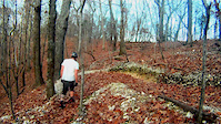
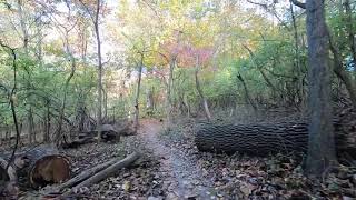
Photos of St. Louis Mountain Bike
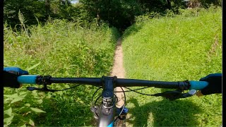
Videos of St. Louis Mountain Bike
trail: Chubb Trail
0:46 |
541 |
Nov 16, 2012

trail: Spring Valley (Inner Loop)
7:14 |
50 |
Nov 5, 2025 , St. Louis
13:49 |
121 |
Aug 10, 2024 , St. Louis

trail: Bootlegger's Run Main Loop
13:49 |
179 |
Aug 9, 2024 , St. Louis
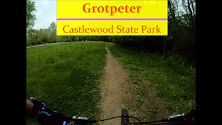
trail: Grotpeter Trail
27:13 |
360 |
Sep 10, 2022 , St. Louis

trail: Bootlegger's Run Main Loop
1:5:19 |
1584 |
May 21, 2021 , St. Louis

trail: Spring Valley (Inner Loop)
22:56 |
403 |
Jun 9, 2020 , St. Louis
trail: Spring Valley (Outer Loop)
22:56 |
621 |
Jun 9, 2020 , St. Louis
Recent Trail Reports
Activity Feed
| username | action | type | title | date |
|---|---|---|---|---|
| Mark5hDuwj | wishlist | trail | activity #97521274 | Jun 21, 2026 @ 2:31pm 2 days |
| 2jhsAB | add | report | activity #97407418 | Jun 20, 2026 @ 9:55am 3 days |
| 2jhsAB | ridden | trail | activity #97407326 | Jun 20, 2026 @ 9:54am 3 days |
| xxdiffxx | comment | trail | activity #97129966 | Jun 16, 2026 @ 12:12pm Jun 16, 2026 |
| JordanVdlGQS | wishlist | trail | activity #97015463 | Jun 14, 2026 @ 5:36pm Jun 14, 2026 |
Recent Comments
| username | type | title | comment | date |
|---|---|---|---|---|
| trail | This is a great trail even after coming from a... | Jun 16, 2026 @ 12:12pm Jun 16, 2026 | ||
| trail | Great beginner trail. Mostly flat and light... | Sep 6, 2025 @ 12:18pm Sep 6, 2025 | ||
| trail | This trail is nicer than previously... | Dec 10, 2023 @ 9:43am Dec 10, 2023 | ||
| trail | The vertical climb and descent numbers are way... | Dec 10, 2023 @ 9:39am Dec 10, 2023 | ||
| trail | Was just in the area and needed a place to... | Dec 1, 2023 @ 8:01am Dec 1, 2023 |
Local Badges
-

10 Green Trails104 awarded -

10 Blue Trails262 awarded -

Epic Ride Climb 2k12 awarded -

Climbing 10k Badge123 awarded -

Climbing 100k Badge11 awarded -

Epic Ride Descent 2k12 awarded
Bike & Skill Parks
| name | type | city | rating |
|---|---|---|---|
| Figure 8 Jumps | skill park | St. Louis |
Activity Type Stats
| activitytype | trails | distance | descent | descent distance | total vertical | rating | global rank | state rank | photos | reports | routes | ridelogs |
|---|---|---|---|---|---|---|---|---|---|---|---|---|
| Mountain Bike | 91 | 125 miles | 9,049 ft | 43 miles | 433 ft | #935 | #367 | 109 | 1,455 | 4 | 38,329 | |
| E-Bike | 15 | 22 miles | 794 ft | 5 miles | 184 ft | #4,181 | #1,376 | 1,168 | 4 | 785 | ||
| Horse | 18 | 16 miles | 1,512 ft | 6 miles | 279 ft | #1,545 | #904 | 830 | ||||
| Hike | 123 | 149 miles | 11,962 ft | 52 miles | 433 ft | #1,243 | #572 | 1,459 | 1,221 | |||
| Trail Running | 125 | 152 miles | 12,106 ft | 54 miles | 433 ft | #1,012 | #376 | 1 | 1,459 | 2,275 | ||
| Snowshoe | 5 | 6 miles | 525 ft | 3 miles | 171 ft | #979 | #479 | |||||
| Nordic Ski | 5 | 6 miles | 525 ft | 3 miles | 171 ft | #1,027 | #433 | 5 |
Frequently Asked Questions About St. Louis
▼
What are the best places to ride in St. Louis?
St. Louis has 14 areas to explore for mountain biking. The top rated areas are:
▼
What are the highest rated mountain biking trails in St. Louis?
The highest rated mountain biking trails in St. Louis are:
- Bootlegger's Run Main Loop (4.5/5)
- Mountain Ridge Connector (4.5/5)
- Bootlegger's Run Western Loop (4.4/5)
- Bluff Trail - North (4.3/5)
- Chubb Trail (4.3/5)
▼
What is the best time of the year to ride in St. Louis?
Based on ride log data, the most popular months to ride in St. Louis are:
- July (265 activities)
- August (211 activities)
- June (191 activities)
▼
Where can I park to ride in St. Louis?
There are 36 parking locations listed in St. Louis. The most popular parking spots are:
- Main Office Parking
- Parking
- Grant's Trail Mile 8
- Centennial Greenway and Katy Trail Parking
- Sherman Beach Parking
Activities
Trails
- By brenthillier
 NSMBA TRAILFORKS & contributors
 - Admins: GORC
- #8602 - 23,272 views
- st. louis activity log | embed map of St. Louis mountain bike trails | st. louis mountain biking points of interest
Downloading of trail gps tracks in kml & gpx formats is enabled for St. Louis.
You must login to download files.