close
-
Layers w
- Weather Layers
- Pro
- Pro
- Pro
- Pro
- Pro
- Pro
- More Layers
- Pro
- Pro
- Pro
- Pro
-
Upgrade to

3D
Trail Conditions
- Unknown
- Snow Groomed
- Snow Packed
- Snow Covered
- Snow Cover Partial
- Freeze/thaw Cycle
- Icy
- Prevalent Mud
- Wet
- Variable
- Ideal
- Dry
- Very Dry
Trail Flow (Ridden Direction)
Trailforks scans users ridelogs to determine the most popular direction each trail is ridden. A good flowing trail network will have most trails flowing in a single direction according to their intension.
The colour categories are based on what percentage of riders are riding a trail in its intended direction.
The colour categories are based on what percentage of riders are riding a trail in its intended direction.
- > 96%
- > 90%
- > 80%
- > 70%
- > 50%
- < 50%
- bi-directional trail
- no data
Trail Last Ridden
Trailforks scans ridelogs to determine the last time a trail was ridden.
- < 2 days
- < 1 week
- < 2 weeks
- < 1 month
- < 6 months
- > 6 months
Trail Ridden Direction
The intended direction a trail should be ridden.
- Downhill Only
- Downhill Primary
- Both Directions
- Uphill Primary
- Uphill Only
- One Direction
Contribute Details
Colors indicate trail is missing specified detail.
- Description
- Photos
- Description & Photos
- Videos
Trail Popularity ?
Trailforks scans ridelogs to determine which trails are ridden the most in the last 9 months.
Trails are compared with nearby trails in the same city region with a possible 25 colour shades.
Think of this as a heatmap, more rides = more kinetic energy = warmer colors.
- most popular
- popular
- less popular
- not popular
ATV/ORV/OHV Filter
Max Vehicle Width
inches
US Cell Coverage
Legend

Radar Time
Activity Recordings
Trailforks uses anonymized public activity data.
?
Activity Recordings
Trailforks uses anonymized public activity data.
?
Personal Heatmap
▶
Activity Types
all
/
none
▶
Options
2
Date range
month
–
Winter Trails
Warning
A routing network for winter maps does not exist. Selecting trails using the winter trails layer has been disabled.
Missing Trails
Most Popular
Least Popular
Trails are colored based on popularity. The more popular a trail is, the more red. Less popular trails trend towards green.
Jump Magnitude Heatmap
Heatmap of where riders jump on trails. Zoom in to see individual jumps, click circles to view jump details.
BC Backroad Status
![map legend]()
Service Road Atlas is a free to use, community-driven service for viewing and creating reports on the numerous back-country service roads around B.C. and Alberta.

Slope Aspect
Direction the slope faces
Trails Deemphasized
Trails are shown in grey.
Only show trails with no bike usage.
Suggested Layers
Based on selected activity type
Save the current map location and zoom level as your default home location whenever this page is loaded.
SaveSaint Paul (abbreviated St. Paul) is the capital of the U.S. state of Minnesota and the county seat of Ramsey County. Situated on high bluffs overlooking a bend in the Mississippi River, Saint Paul is a regional business hub and the center of Minnesota's government. The Minnesota State Capitol and the state government offices all sit on a hill close to the city's downtown district. One of the oldest cities in Minnesota, Saint Paul has several historic neighborhoods and landmarks, such as the Summit Avenue Neighborhood and the James J. Hill House. Like the nearby and larger city of Minneapolis, Saint Paul is known for its cold, snowy winters and humid summers.
As of 2020, its population was 311,527, making it the 63rd-largest city in the United States, the 11th-most populous in the Midwest, and the second-most populous in Minnesota. Most of the city lies east of the Mississippi River at the confluence with the Minnesota River. Minneapolis is mostly across the Mississippi River to the west. Together, they are known as the "Twin Cities". They are the core of Minneapolis–Saint Paul metropolitan area, home to nearly 3.7 million and the third-largest in the Midwest.
As of 2020, its population was 311,527, making it the 63rd-largest city in the United States, the 11th-most populous in the Midwest, and the second-most populous in Minnesota. Most of the city lies east of the Mississippi River at the confluence with the Minnesota River. Minneapolis is mostly across the Mississippi River to the west. Together, they are known as the "Twin Cities". They are the core of Minneapolis–Saint Paul metropolitan area, home to nearly 3.7 million and the third-largest in the Midwest.
source: Wikipedia
Activities Click to view
- Mountain Bike
75 trails
- E-Bike
69 trails
- Gravel Bike
0 trails
- Adaptive Bike
0 trails
- Winter Fat Bike
0 trails
- Horse
0 trails
- Hike
78 trails
- Trail Running
80 trails
- Dirtbike/Moto
0 trails
- Observed Trials
0 trails
- ATV/ORV/OHV
0 trails
- Snowmobile
0 trails
- Snowshoe
1 trails
- Downhill Ski
0 trails
- Backcountry Ski
0 trails
- Nordic Ski
19 trails
Region Details
- 4
- 21
- 20
- 18
- 7
Region Status
Open as of Apr 25, 2026Local Trail Association
Stats
- Avg Trail Rating
- Trails (view details)
- 74
- Trails Mountain Bike
- 77
- Trails E-Bike
- 69
- Trails Hike
- 80
- Trails Trail Running
- 80
- Trails Snowshoe
- 1
- Trails Nordic Ski
- 19
- Total Distance
- 99 miles
- Total Descent
- 4,269 ft
- Total Vertical
- 370 ft
- Highest Trailhead
- 1,058 ft
- Reports
- 750
- Photos
- 54
- Ridden Counter
- 25,842
Sub Regions
-
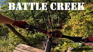
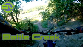
Battle Creek
- 1
- 13
- 12
- 7
-
Battle Creek Regional Park
- 3
-
Crosby Farm Regional Park
- 1
- 1
- 1
-
Hidden Falls Regional Park
- 2
- 1
- 4
-
Swede Hollow Park
- 1
-
Trout Brook Nature Sanctuary
- 1
- 4
Popular St. Paul Mountain Biking Trails
• 25 ★ 0.0 • 4,603 ft • 43 ft • 1,681 •
Double track connecting multiple trails. Mostly dirt and grass.
• 95 ★ 4.6 • 2,375 ft • 25 ft • 870 •
Downhill trail with several jumps and a few technical root sections. Wicked fun!!!
• 90 ★ 4.5 • 2,156 ft • 177 ft • 808 •
Popular blue difficulty singletrack. This multi-use trail can be used downhill primary and has a hard overall physical rating with a 177 ft blue climb. On average it takes 4 minutes to complete this trail.
• 80 ★ 3.0 • 2,375 ft • 124 ft • 758 •
Popular blue difficulty singletrack. This multi-use trail can be used one direction and has a moderate overall physical rating with a 124 ft blue climb. Trail visibility is always easy to follow. On average it takes 4 minutes to complete this trail.
• 100 ★ 0.0 • 1,975 ft • 134 ft • 740 •
This trail allows alternate access from the parking area via without having to get onto the road or pedal up . This is a great way to make multiple loops to The , Luge or . On a map it will look like one part of the trail overlaps with...
• 95 ★ 3.2 • 2,254 ft • 86 ft • 735 •
Popular black diamond difficulty singletrack. This multi-use trail can be used uphill primary and has a hard overall physical rating with a 86 ft black diamond climb. On average it takes 6 minutes to complete this trail.
• 90 ★ 3.5 • 1,552 ft • 46 ft • 729 •
Popular blue difficulty singletrack. This multi-use trail can be used downhill primary and has a moderate overall physical rating with a 46 ft blue climb. On average it takes 3 minutes to complete this trail.
• 95 ★ 3.8 • 2,156 ft • 40 ft • 728 •
Downhill only trail connects to the base of . The corners, dips, and bends are designed to help maintain your speed and maximize ones enjoyment. You can now ride from the lower lot to the base of without riding on .
St. Paul Mountain Bike Routes
★ 4.0 • 9 miles • 1,172 ft • 36 • Loop •
A 10-mile loop at Battle Creek including the new connector trails to Big Wheezy Honeybadger.
10 miles • 1,300 ft • 21 • Loop •
This loop plays the BC hits in a reasonable to navigate fashion
★ 2.5 • 10 miles • 1,258 ft • 22 • Loop •
Fairly standard 10 mile loop that covers most of what BC has to offer.
• 19 miles • 1,692 ft • 22 •
• 28 miles • 2,433 ft • 36 •
• 14 miles • 1,853 ft • 37 •
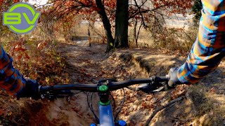
Photos of St. Paul Mountain Bike
Videos of St. Paul Mountain Bike
trail: Goat
15:10 |
248 |
Mar 23, 2024 , St. Paul

trail: Wall of Death
2:28 |
749 |
Jun 17, 2022 , St. Paul

trail: Goat
5:07 |
527 |
Jun 9, 2022 , St. Paul
youtuber
![Time to get back to Battle Creek | Minnesota...]()
11:14 |
360 |
Sep 26, 2021

youtuber
![Shaking the rust off | Battle Creek Mountain...]()

9:53 |
261 |
Apr 9, 2021
youtuber
![Watch out for the Dingos at Battle Creek]()
trail: Dingo Switchback
2:30 |
406 |
Mar 3, 2021 , St. Paul
youtuber
![Enjoying the Fall Colors]()
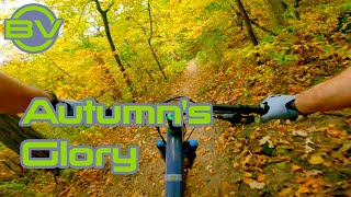
5:56 |
273 |
Oct 6, 2020
Recent Trail Reports
| status | trail | date | condition | info | user |
|---|---|---|---|---|---|
| Dingo Switchback | Apr 25, 2026 @ 3:06pm (America/Chicago) Apr 25, 2026 | Dry | chucknasty | ||
| Travis' Trail | Apr 25, 2026 @ 3:06pm (America/Chicago) Apr 25, 2026 | Ideal | chucknasty | ||
| Wall of Death | Apr 25, 2026 @ 3:06pm (America/Chicago) Apr 25, 2026 | Ideal | chucknasty | ||
| Singletrack to Road Crossing | Apr 25, 2026 @ 3:06pm (America/Chicago) Apr 25, 2026 | Ideal | chucknasty | ||
| Higher Ed. | Apr 25, 2026 @ 3:06pm (America/Chicago) Apr 25, 2026 | Ideal | chucknasty | ||
| Enchanted Forest 2023 | Apr 25, 2026 @ 3:06pm (America/Chicago) Apr 25, 2026 | Ideal | chucknasty | ||
| Pine Climb | Apr 25, 2026 @ 3:06pm (America/Chicago) Apr 25, 2026 | Ideal | chucknasty | ||
| Drop Into Pine | Apr 25, 2026 @ 3:06pm (America/Chicago) Apr 25, 2026 | Ideal | chucknasty | ||
| Fern Gully | Apr 25, 2026 @ 3:06pm (America/Chicago) Apr 25, 2026 | Ideal | chucknasty | ||
| Goat | Apr 25, 2026 @ 3:06pm (America/Chicago) Apr 25, 2026 | Ideal | chucknasty |
Activity Feed
| username | action | type | title | date |
|---|---|---|---|---|
| BikerBear900 | wishlist | region | activity #97154239 | Jun 16, 2026 @ 6:36pm 2 days |
| DaveOrrick | ridden | trail | activity #97054601 and 2 more | Jun 15, 2026 @ 11:18am Jun 15, 2026 |
| Nickmu5fS5 | wishlist | region | activity #96875040 | Jun 13, 2026 @ 7:32am Jun 13, 2026 |
| lisaelizabeth78 | wishlist | region | activity #96607660 | Jun 9, 2026 @ 8:30am Jun 9, 2026 |
| mkgm1J | wishlist | route | activity #96600934 | Jun 9, 2026 @ 6:17am Jun 9, 2026 |
Recent Comments
| username | type | title | comment | date |
|---|---|---|---|---|
| trail | The Gateway trail is a Great metro area... | May 29, 2026 @ 2:29pm May 29, 2026 | ||
| trail | Big agree on adding a way to lap it. How can... | Oct 1, 2025 @ 11:11am Oct 1, 2025 | ||
| trail | Fun if you actually do the drop in at the... | Oct 1, 2025 @ 10:38am Oct 1, 2025 | ||
| trail | Super mid, could be a blue square | Oct 1, 2025 @ 10:37am Oct 1, 2025 | ||
| trail | Pretty mid honestly, could be demoted to a... | Oct 1, 2025 @ 10:36am Oct 1, 2025 |
Local Badges
-

10 Blue Trails453 awarded -

Epic Ride Climb 2k5 awarded -

Climbing 10k Badge84 awarded -

Climbing 100k Badge0 awarded -

Epic Ride Descent 2k5 awarded -

Descent 10k Badge84 awarded
Activity Type Stats
| activitytype | trails | distance | descent | descent distance | total vertical | rating | global rank | state rank | photos | reports | routes | ridelogs |
|---|---|---|---|---|---|---|---|---|---|---|---|---|
| Mountain Bike | 75 | 99 miles | 4,140 ft | 31 miles | 371 ft | #883 | #347 | 54 | 750 | 3 | 17,814 | |
| E-Bike | 69 | 86 miles | 2,628 ft | 26 miles | 371 ft | #2,077 | #932 | 651 | 2 | 461 | ||
| Hike | 78 | 97 miles | 4,147 ft | 31 miles | 371 ft | #2,823 | #1,056 | 745 | 1 | 475 | ||
| Trail Running | 80 | 97 miles | 4,147 ft | 31 miles | 371 ft | #2,289 | #707 | 745 | 1 | 670 | ||
| Snowshoe | 1 | 5,079 ft | 13 ft | 1,309 ft | 16 ft | #1,072 | #543 | 2 | 23 | |||
| Nordic Ski | 19 | 26 miles | 719 ft | 9 miles | 344 ft | #465 | #138 | 1,033 |
Frequently Asked Questions About St. Paul
▼
What are the best places to ride in St. Paul?
St. Paul has 12 areas to explore for mountain biking. The top rated areas are:
▼
What are the highest rated mountain biking trails in St. Paul?
The highest rated mountain biking trails in St. Paul are:
- Goat (4.4/5)
- Wall of Death (4.3/5)
- The Chute (4.1/5)
- Big Wheezy (4.1/5)
- Dingo Switchback (4/5)
▼
What is the best time of the year to ride in St. Paul?
Based on ride log data, the most popular months to ride in St. Paul are:
- July (140 activities)
- May (101 activities)
- September (95 activities)
▼
Where can I park to ride in St. Paul?
Activities
Trails
Points of Interest
- By Redpine
 TRAILFORKS & contributors
 - Admins: apply
- #5537 - 8,877 views
- st. paul activity log | embed map of St. Paul mountain bike trails | st. paul mountain biking points of interest
Downloading of trail gps tracks in kml & gpx formats is enabled for St. Paul.
You must login to download files.