close
-
Layers w
- Weather Layers
- Pro
- Pro
- Pro
- Pro
- Pro
- Pro
- More Layers
- Pro
- Pro
- Pro
- Pro
-
Upgrade to

3D
Trail Conditions
- Unknown
- Snow Groomed
- Snow Packed
- Snow Covered
- Snow Cover Partial
- Freeze/thaw Cycle
- Icy
- Prevalent Mud
- Wet
- Variable
- Ideal
- Dry
- Very Dry
Trail Flow (Ridden Direction)
Trailforks scans users ridelogs to determine the most popular direction each trail is ridden. A good flowing trail network will have most trails flowing in a single direction according to their intension.
The colour categories are based on what percentage of riders are riding a trail in its intended direction.
The colour categories are based on what percentage of riders are riding a trail in its intended direction.
- > 96%
- > 90%
- > 80%
- > 70%
- > 50%
- < 50%
- bi-directional trail
- no data
Trail Last Ridden
Trailforks scans ridelogs to determine the last time a trail was ridden.
- < 2 days
- < 1 week
- < 2 weeks
- < 1 month
- < 6 months
- > 6 months
Trail Ridden Direction
The intended direction a trail should be ridden.
- Downhill Only
- Downhill Primary
- Both Directions
- Uphill Primary
- Uphill Only
- One Direction
Contribute Details
Colors indicate trail is missing specified detail.
- Description
- Photos
- Description & Photos
- Videos
Trail Popularity ?
Trailforks scans ridelogs to determine which trails are ridden the most in the last 9 months.
Trails are compared with nearby trails in the same city region with a possible 25 colour shades.
Think of this as a heatmap, more rides = more kinetic energy = warmer colors.
- most popular
- popular
- less popular
- not popular
ATV/ORV/OHV Filter
Max Vehicle Width
inches
US Cell Coverage
Legend

Radar Time
Activity Recordings
Trailforks uses anonymized public activity data.
?
Activity Recordings
Trailforks uses anonymized public activity data.
?
Personal Heatmap
▶
Activity Types
all
/
none
▶
Options
2
Date range
month
–
Winter Trails
Warning
A routing network for winter maps does not exist. Selecting trails using the winter trails layer has been disabled.
Missing Trails
Most Popular
Least Popular
Trails are colored based on popularity. The more popular a trail is, the more red. Less popular trails trend towards green.
Jump Magnitude Heatmap
Heatmap of where riders jump on trails. Zoom in to see individual jumps, click circles to view jump details.
BC Backroad Status
![map legend]()
Service Road Atlas is a free to use, community-driven service for viewing and creating reports on the numerous back-country service roads around B.C. and Alberta.

Slope Aspect
Direction the slope faces
Trails Deemphasized
Trails are shown in grey.
Only show trails with no bike usage.
Suggested Layers
Based on selected activity type
Save the current map location and zoom level as your default home location whenever this page is loaded.
Save
No description for Stanislaus County has been added yet!
Login or register to submit one.
Activities Click to view
- Mountain Bike
8 trails
- E-Bike
4 trails
- Hike
4 trails
- Trail Running
4 trails
Region Details
- 3
- 4
- 1
Stats
- Avg Trail Rating
- Trails (view details)
- 8
- Trails Mountain Bike
- 8
- Trails E-Bike
- 4
- Trails Hike
- 4
- Trails Trail Running
- 4
- Total Distance
- 19 miles
- Total Descent
- 2,049 ft
- Total Vertical
- 743 ft
- Highest Trailhead
- 775 ft
- Reports
- 16
- Photos
- 49
- Ridden Counter
- 368
Popular Stanislaus County Mountain Biking Trails
• 90 ★ 4.7 • 5 miles • 739 ft • 156 •
This trail is single track that meanders along side and crosses a paved path a few times. The paved path connects multiple city parks.
• 100 ★ 4.5 • 5 miles • 509 ft • 124 •
Local riders put a lot of effort into scratching in single track into the once over-grown abandoned park. The singletrack hugs the creek, passes under three bridges and returns to access road in spots. The trail skirts two city golf...
• 65 ★ 0.0 • 5 miles • 12 ft • 7 •
Moderately popular green difficulty singletrack. This multi-use trail can be used both directions. On average it takes 20 minutes to complete this trail.
• 5 ★ 5.0 • 3,983 ft • 145 ft • 1 •
Small trail that runs with the cows outside patterson CA
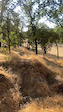
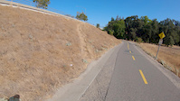
Photos of Stanislaus County Mountain Bike
Videos of Stanislaus County Mountain Bike
trail: Dry Creek Trail
0:10 |
140 |
Jul 29, 2021
trail: Dry Creek Trail
5:16 |
292 |
Sep 24, 2019
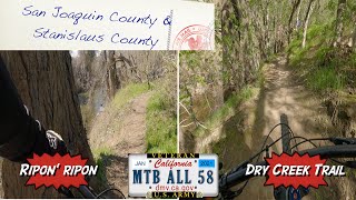
trail: Dry Creek Trail
18:11 |
424 |
Feb 16, 2021 , Modesto
Recent Trail Reports
| status | trail | date | condition | info | user |
|---|---|---|---|---|---|
| Tuolumne River Trail Gateway Park (TRT) Tuolumne Riverside Trail (TRT) | May 3, 2023 @ 5:01pm May 3, 2023 | Wet | Kacooper33 | ||
| Dry Creek Trail Dry Creek Trails | Jul 4, 2022 @ 6:04pm Jul 4, 2022 | Dry | SadKingBilly | ||
| TRT Connector Dry Creek Trails | Jun 11, 2022 @ 7:48am Jun 11, 2022 | Ideal | TRTrider |
Activity Feed
| username | action | type | title | date |
|---|---|---|---|---|
| StevenwJmnxL | wishlist | trail | activity #92641365 | Apr 14, 2026 @ 9:55pm Apr 14, 2026 |
| Ambrose1988 | wishlist | trail | activity #80976140 | Sep 23, 2025 @ 2:51pm Sep 23, 2025 |
| AlexEcczub | difficultyvote | trail | activity #79289102 | Aug 30, 2025 @ 5:13pm Aug 30, 2025 |
| geojongo | wishlist | trail | activity #79033499 | Aug 27, 2025 @ 1:03am Aug 27, 2025 |
| singletraksam | update | region | activity #76697989 | Jul 25, 2025 @ 4:50pm Jul 25, 2025 |
Recent Comments
| username | type | title | comment | date |
|---|---|---|---|---|
| trail | Nice trail with a mix of beginner and... | Feb 23, 2023 @ 12:54am Feb 23, 2023 | ||
| report | Am | Dec 2, 2022 @ 9:55am Dec 2, 2022 | ||
| report | Stream down | Oct 6, 2021 @ 12:24pm Oct 6, 2021 | ||
| trail | Took my 9yo son out today for the first time... | Sep 19, 2021 @ 3:44pm Sep 19, 2021 | ||
| trail | Only discovered this trail at the end of 2019... | Feb 24, 2021 @ 9:42am Feb 24, 2021 |
Activity Type Stats
| activitytype | trails | distance | descent | descent distance | total vertical | rating | global rank | state rank | photos | reports | routes | ridelogs |
|---|---|---|---|---|---|---|---|---|---|---|---|---|
| Mountain Bike | 8 | 19 miles | 2,047 ft | 6 miles | 741 ft | 49 | 16 | 8,130 | ||||
| E-Bike | 4 | 7 miles | 374 ft | 2 miles | 430 ft | 9 | 186 | |||||
| Hike | 4 | 12 miles | 1,568 ft | 5 miles | 741 ft | 16 | 176 | |||||
| Trail Running | 4 | 12 miles | 1,568 ft | 5 miles | 741 ft | 16 | 1 |
Frequently Asked Questions About Stanislaus County
▼
What are the best places to ride in Stanislaus County?
Stanislaus County has 3 areas to explore for mountain biking. The top rated areas are:
▼
What are the highest rated mountain biking trails in Stanislaus County?
The highest rated mountain biking trails in Stanislaus County are:
- Tuolumne River Trail Gateway Park (TRT) (4.2/5)
- Dry Creek Trail (4.2/5)
- Janky orchard spring (4.1/5)
- freeway overlook loop (4.1/5)
- Virginia Corridor Bike Path (0/5)
▼
What is the best time of the year to ride in Stanislaus County?
Based on ride log data, the most popular months to ride in Stanislaus County are:
- July (58 activities)
- June (40 activities)
- April (36 activities)
▼
What is the longest trail in Stanislaus County?
The longest trail in Stanislaus County is Dry Creek Trail at 4.8 miles. View all trails sorted by distance.
Activities
Trails
Points of Interest
- By brenthillier
 NSMBA TRAILFORKS & contributors
 - Admins: jpmcghee, sanfret, brianpetry
- #7916 - 3,815 views
- stanislaus county activity log | embed map of Stanislaus County mountain bike trails | stanislaus county mountain biking points of interest
Downloading of trail gps tracks in kml & gpx formats is enabled for Stanislaus County.
You must login to download files.