close
-
Layers w
- Weather Layers
- Pro
- Pro
- Pro
- Pro
- Pro
- Pro
- More Layers
- Pro
- Pro
- Pro
- Pro
-
Upgrade to

3D
Trail Conditions
- Unknown
- Snow Groomed
- Snow Packed
- Snow Covered
- Snow Cover Partial
- Freeze/thaw Cycle
- Icy
- Prevalent Mud
- Wet
- Variable
- Ideal
- Dry
- Very Dry
Trail Flow (Ridden Direction)
Trailforks scans users ridelogs to determine the most popular direction each trail is ridden. A good flowing trail network will have most trails flowing in a single direction according to their intension.
The colour categories are based on what percentage of riders are riding a trail in its intended direction.
The colour categories are based on what percentage of riders are riding a trail in its intended direction.
- > 96%
- > 90%
- > 80%
- > 70%
- > 50%
- < 50%
- bi-directional trail
- no data
Trail Last Ridden
Trailforks scans ridelogs to determine the last time a trail was ridden.
- < 2 days
- < 1 week
- < 2 weeks
- < 1 month
- < 6 months
- > 6 months
Trail Ridden Direction
The intended direction a trail should be ridden.
- Downhill Only
- Downhill Primary
- Both Directions
- Uphill Primary
- Uphill Only
- One Direction
Contribute Details
Colors indicate trail is missing specified detail.
- Description
- Photos
- Description & Photos
- Videos
Trail Popularity ?
Trailforks scans ridelogs to determine which trails are ridden the most in the last 9 months.
Trails are compared with nearby trails in the same city region with a possible 25 colour shades.
Think of this as a heatmap, more rides = more kinetic energy = warmer colors.
- most popular
- popular
- less popular
- not popular
ATV/ORV/OHV Filter
Max Vehicle Width
inches
US Cell Coverage
Legend

Radar Time
Activity Recordings
Trailforks uses anonymized public activity data.
?
Activity Recordings
Trailforks uses anonymized public activity data.
?
Personal Heatmap
▶
Activity Types
all
/
none
▶
Options
2
Date range
month
–
Winter Trails
Warning
A routing network for winter maps does not exist. Selecting trails using the winter trails layer has been disabled.
Missing Trails
Most Popular
Least Popular
Trails are colored based on popularity. The more popular a trail is, the more red. Less popular trails trend towards green.
Jump Magnitude Heatmap
Heatmap of where riders jump on trails. Zoom in to see individual jumps, click circles to view jump details.
BC Backroad Status
![map legend]()
Service Road Atlas is a free to use, community-driven service for viewing and creating reports on the numerous back-country service roads around B.C. and Alberta.

Slope Aspect
Direction the slope faces
Trails Deemphasized
Trails are shown in grey.
Only show trails with no bike usage.
Suggested Layers
Based on selected activity type
Save the current map location and zoom level as your default home location whenever this page is loaded.
Save
No description for Stanthorpe has been added yet!
Login or register to submit one.
Activities Click to view
- Mountain Bike
28 trails
- E-Bike
20 trails
- Gravel Bike
2 trails
- Adaptive Bike
0 trails
- Hike
22 trails
- Trail Running
22 trails
Region Details
- 2
- 7
- 8
- 5
- 1
Region Status
Open as of Oct 3, 2025Stats
- Avg Trail Rating
- Trails (view details)
- 23
- Trails Mountain Bike
- 28
- Trails E-Bike
- 20
- Trails Gravel Bike
- 2
- Trails Hike
- 22
- Trails Trail Running
- 22
- Total Distance
- 24 miles
- Total Descent
- 3,053 ft
- Total Vertical
- 995 ft
- Highest Trailhead
- 3,663 ft
- Reports
- 65
- Photos
- 57
- Ridden Counter
- 1,994
Sub Regions
-
Broadwater State Forest
- 2
- 1
-
Girraween MTB Trails
- 2
- 1
-
Mt Marlay MTB Trails
- 2
- 4
- 5
- 1
Popular Stanthorpe Mountain Biking Trails
• 90 ★ 3.5 • 1,639 ft • 39 ft • 255 •
Trail designed and built by Trailworx and Southern Downs Mountain Biking Club. A wonderful ride through different terrain that Mt Marlay has to offer. Keep and eye out for what gives the trail its name!
• 95 ★ 4.5 • 4,423 ft • 3 ft • 200 •
This 2 way black diamond Trail has been designed and built by Trailworx and Southern Downs Mountain Biking Club. An incredible ride which puts the biggest smile on your face with some wonderfully unique features. Packed with plenty of...
• 80 ★ 4.5 • 4,751 ft • 82 ft • 198 •
First ever single trail in our beautiful town of Stanthorpe, designed and built by Trailworx and Southern Downs Mountain Biking Club. This was the first trail in our trail network which has shown great potential as a wonderful riding...
• 75 ★ 4.4 • 2,861 ft • 40 ft • 195 •
Trail Designed and Built by Trailworx and Southern Downs Mountain Biking Club. Featuring Plenty of what Stanthorpe is known for, Granite Rock! Wonder ride with plenty of features to keep that smile on your face.
• 85 ★ 4.5 • 2,825 ft • 0 ft • 172 •
This 1 Way Enduro Trail has been designed and built by Trailworx and Southern Downs Mountain Biking Club. Super fun and rocky trail that puts a smile on your face. Can be shuttled from Mt Marlay Access Rd and exit for shuttles onto...
• 100 ★ 5.0 • 4,491 ft • 44 ft • 168 •
Southern Downs Mountain Biking Club is proud to welcome you to Zoolander" this trail has some great tech features using or amazing granite boulders found in our region. This trail is super cool to ride down with features for all riders....
• 70 ★ 3.0 • 279 ft • 4 ft • 119 •
Link between and On the Rock Trails. Watch for Panda's in the Bambo!
• 95 ★ 4.5 • 2,365 ft • 7 ft • 77 •
Recently completed by Trailworx, packs a big punch. Rocky out crops with super techy features ensures an amazing experience on the Granite Belt. This Double Black trail is not for the faint hearted and will put a smile on the face of...
Photos of Stanthorpe Mountain Bike
Videos of Stanthorpe Mountain Bike
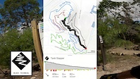
trail: Tank Slapper
4:20 |
124 |
Aug 24, 2021
trail: Zoolander
5:24 |
106 |
Aug 23, 2021

trail: Hammerhead
4:52 |
93 |
Aug 20, 2021
trail: Rusty
0:38 |
1082 |
Jan 22, 2018

youtuber
![This place is a must ride if you live in...]()
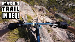
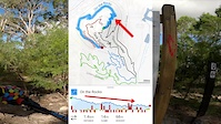
trail: Under the Radar
22:38 |
162 |
Oct 23, 2024 , Stanthorpe
youtuber
![Mount Marlay | Full Run RAW 2022]()
41:26 |
354 |
May 1, 2022
youtuber
![I got redemption. But still crashed…]()
trail: Under the Radar
8:01 |
391 |
Apr 11, 2022 , Stanthorpe
Recent Trail Reports
| status | trail | date | condition | info | user |
|---|---|---|---|---|---|
| Zoolander | Oct 4, 2025 @ 10:31am (Australia/Brisbane) Oct 3, 2025 | Dry | JH8ir7 | ||
| Under the Radar | Oct 4, 2025 @ 10:29am (Australia/Brisbane) Oct 3, 2025 | Ideal | JH8ir7 | ||
| Creek Trail | May 24, 2025 @ 11:27am May 24, 2025 | Ideal | DamienBvRhTK | ||
| Happy Snappy | Mar 31, 2024 @ 3:04am Mar 31, 2024 | Wet | jcgravelrides | ||
| Green Granite | Dec 31, 2023 @ 4:28pm Dec 31, 2023 | Variable | Monksgobiking | ||
| Grape Escape | Apr 23, 2023 @ 9:16am Apr 23, 2023 | Wet | Byronbike | ||
| Tank Slapper | Apr 23, 2023 @ 9:16am Apr 23, 2023 | Wet | Byronbike | ||
| Rusty | Apr 23, 2023 @ 9:16am Apr 23, 2023 | Wet | Byronbike | ||
| On the Rocks Link | Apr 23, 2023 @ 9:16am Apr 23, 2023 | Wet | Byronbike | ||
| Hammerhead | Apr 23, 2023 @ 9:16am Apr 23, 2023 | Wet | Byronbike |
Activity Feed
| username | action | type | title | date |
|---|---|---|---|---|
| ak0047 | add | poi | activity #96343377 and 1 more | Jun 5, 2026 @ 10:38pm Jun 5, 2026 |
| ak0047 | vote | trail | activity #95218182 | May 21, 2026 @ 7:32pm May 21, 2026 |
| ak0047 | add | poi | activity #94668343 | May 13, 2026 @ 8:51pm May 13, 2026 |
| ak0047 | ridden | trail | activity #93667705 | Apr 29, 2026 @ 1:03pm Apr 29, 2026 |
| ak0047 | vote | trail | activity #93667703 | Apr 29, 2026 @ 1:03pm Apr 29, 2026 |
Recent Comments
| username | type | title | comment | date |
|---|---|---|---|---|
| trail | This is another example of how Cross Country... | Mar 13, 2026 @ 10:28pm Mar 13, 2026 | ||
| trail | Good trail, good flow and tech | Jan 19, 2026 @ 12:46pm Jan 19, 2026 | ||
| trail | As a beginner MTB rider this wouldn’t be... | Jul 7, 2025 @ 6:22pm Jul 7, 2025 | ||
| trail | I only rode the top section as it was too... | Mar 30, 2025 @ 12:25am Mar 30, 2025 | ||
| trail | Fun trail. Rocks are interesting and similar... | Mar 30, 2025 @ 12:23am Mar 30, 2025 |
Local Badges
-

Epic Ride Climb 2k14 awarded -

Climbing 10k Badge8 awarded -

Climbing 100k Badge4 awarded -

Epic Ride Descent 2k16 awarded -

Descent 10k Badge9 awarded -

Descent 100k Badge4 awarded
Activity Type Stats
| activitytype | trails | distance | descent | descent distance | total vertical | rating | global rank | state rank | photos | reports | routes | ridelogs |
|---|---|---|---|---|---|---|---|---|---|---|---|---|
| Mountain Bike | 28 | 24 miles | 3,051 ft | 11 miles | 994 ft | #3,568 | #145 | 57 | 65 | 3,789 | ||
| E-Bike | 20 | 17 miles | 2,182 ft | 8 miles | 436 ft | #3,729 | #174 | 55 | 183 | |||
| Gravel Bike | 2 | #267 | #101 | 6 | ||||||||
| Hike | 22 | 22 miles | 2,628 ft | 10 miles | 994 ft | #5,631 | #181 | 61 | 622 | |||
| Trail Running | 22 | 22 miles | 2,628 ft | 10 miles | 994 ft | #5,046 | #163 | 61 | 61 |
Frequently Asked Questions About Stanthorpe
▼
What are the best places to ride in Stanthorpe?
Stanthorpe has 3 areas to explore for mountain biking. The top rated areas are:
▼
What are the highest rated mountain biking trails in Stanthorpe?
The highest rated mountain biking trails in Stanthorpe are:
- Hammerhead Link (4.2/5)
- Hammerhead (4.2/5)
- Tank Slapper (4.2/5)
- Zoolander (4.1/5)
- Canadian Breakfast (4.1/5)
▼
What is the best time of the year to ride in Stanthorpe?
Based on ride log data, the most popular months to ride in Stanthorpe are:
- October (23 activities)
- April (19 activities)
- December (18 activities)
▼
Where can I park to ride in Stanthorpe?
Check the Stanthorpe trail map for trailhead and parking information. Community members regularly update access and parking details for trails in the area.
Activities
Trails
- By brenthillier
 NSMBA TRAILFORKS & contributors
 - Admins: apply
- #15030 - 13,035 views
- stanthorpe activity log | embed map of Stanthorpe mountain bike trails | stanthorpe mountain biking points of interest
Downloading of trail gps tracks in kml & gpx formats is enabled for Stanthorpe.
You must login to download files.