close
-
Layers w
- Weather Layers
- Pro
- Pro
- Pro
- Pro
- Pro
- Pro
- More Layers
- Pro
- Pro
- Pro
- Pro
-
Upgrade to

3D
Trail Conditions
- Unknown
- Snow Groomed
- Snow Packed
- Snow Covered
- Snow Cover Partial
- Freeze/thaw Cycle
- Icy
- Prevalent Mud
- Wet
- Variable
- Ideal
- Dry
- Very Dry
Trail Flow (Ridden Direction)
Trailforks scans users ridelogs to determine the most popular direction each trail is ridden. A good flowing trail network will have most trails flowing in a single direction according to their intension.
The colour categories are based on what percentage of riders are riding a trail in its intended direction.
The colour categories are based on what percentage of riders are riding a trail in its intended direction.
- > 96%
- > 90%
- > 80%
- > 70%
- > 50%
- < 50%
- bi-directional trail
- no data
Trail Last Ridden
Trailforks scans ridelogs to determine the last time a trail was ridden.
- < 2 days
- < 1 week
- < 2 weeks
- < 1 month
- < 6 months
- > 6 months
Trail Ridden Direction
The intended direction a trail should be ridden.
- Downhill Only
- Downhill Primary
- Both Directions
- Uphill Primary
- Uphill Only
- One Direction
Contribute Details
Colors indicate trail is missing specified detail.
- Description
- Photos
- Description & Photos
- Videos
Trail Popularity ?
Trailforks scans ridelogs to determine which trails are ridden the most in the last 9 months.
Trails are compared with nearby trails in the same city region with a possible 25 colour shades.
Think of this as a heatmap, more rides = more kinetic energy = warmer colors.
- most popular
- popular
- less popular
- not popular
ATV/ORV/OHV Filter
Max Vehicle Width
inches
US Cell Coverage
Legend

Radar Time
Activity Recordings
Trailforks uses anonymized public activity data.
?
Activity Recordings
Trailforks uses anonymized public activity data.
?
Personal Heatmap
▶
Activity Types
all
/
none
▶
Options
2
Date range
month
–
Winter Trails
Warning
A routing network for winter maps does not exist. Selecting trails using the winter trails layer has been disabled.
Missing Trails
Most Popular
Least Popular
Trails are colored based on popularity. The more popular a trail is, the more red. Less popular trails trend towards green.
Jump Magnitude Heatmap
Heatmap of where riders jump on trails. Zoom in to see individual jumps, click circles to view jump details.
BC Backroad Status
![map legend]()
Service Road Atlas is a free to use, community-driven service for viewing and creating reports on the numerous back-country service roads around B.C. and Alberta.

Slope Aspect
Direction the slope faces
Trails Deemphasized
Trails are shown in grey.
Only show trails with no bike usage.
Suggested Layers
Based on selected activity type
Save the current map location and zoom level as your default home location whenever this page is loaded.
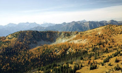
SaveThe Stehekin valley has long served as a passageway for travelers, linking Washington’s interior wilderness to the rugged Cascade Mountains. Today Stehekin offers vistors an escape from the hustle of the modern day world. Nestled at the headwaters of Lake Chelan, the third deepest lake in the United States, the Stehekin community lives life a little slower.
There are no roads into Stehekin. Connected to the outside world only by foot, boat or plane, the voyage to Stehekin is part of the experience and once you’ve arrived, a variety of historical, cultural, and outdoor activities will connect you with the majestic surroundings. Stehekin serves as a hub to explore the 61,949-acre Lake Chelan National Recreation Area and a gateway to the rest of the North Cascades National Park Service Complex, Stephen Mather Wilderness, and adjacent National Forest Wilderness Areas.
There are no roads into Stehekin. Connected to the outside world only by foot, boat or plane, the voyage to Stehekin is part of the experience and once you’ve arrived, a variety of historical, cultural, and outdoor activities will connect you with the majestic surroundings. Stehekin serves as a hub to explore the 61,949-acre Lake Chelan National Recreation Area and a gateway to the rest of the North Cascades National Park Service Complex, Stephen Mather Wilderness, and adjacent National Forest Wilderness Areas.
source: North Cascades NP | Stehekin
Activities Click to view
- Hike
59 trails
- Mountain Bike
4 trails
- Horse
25 trails
- Trail Running
53 trails
- Snowshoe
9 trails
- Backcountry Ski
9 trails
Region Details
- 3
- 1
Region Status
Open as of Sep 4, 2025Stats
- Trails (view details)
- 59
- Trails Mountain Bike
- 4
- Trails Horse
- 25
- Trails Hike
- 59
- Trails Trail Running
- 53
- Trails Snowshoe
- 9
- Trails Backcountry Ski
- 9
- Total Distance
- 198 miles
- Total Descent Distance
- 57 miles
- Total Descent
- 23,780 ft
- Total Vertical
- 7,931 ft
- Highest Trailhead
- 9,034 ft
- Reports
- 4
- Photos
- 10
- Ridden Counter
- 584
Articles

The Best Road Trips to Take This Summer Across the U.S.
Jul 3, 2025 from outsideonline.com
An expert roadtripper's guide to the best American road trips based on their proximity to adventure—from fly fishing holes to flowy singletrack...
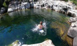
The 9 Best Swimming Holes in Our National Parks
Jun 20, 2025 from outsideonline.com
From waterfalls to deep plunge pools, here the best natural pools for cooling off this summer in national parks.
Lake Chelan National Recreation Area: Coon Lake
Sep 20, 2013 from backpacker.com
Climb above the Stehekin River Valley, passing rugged cliffs and bird's-eye views, to a remote mountain lake at the foot of McGregor Mountain.
America's Best-Kept Secrets: Lake Chelan-Sawtooth Wilderness, WA
Feb 28, 2011 from backpacker.com
→ In An alpine park that’s as scenic—but not as stormy—as its famous neighbor ← OutNorth Cascades National Park’s fickle weather Hike...
Sub Regions
-
Lake Chelan National Rec. Area (North Cascades N.P.)
- 3
- 1
Popular Stehekin Mountain Biking Trails
• 5 ★ 0.0 • 279 ft • 0 ft • • hike
Less popular blue difficulty singletrack. This hike primary trail can be used both directions.
• 5 ★ 0.0 • 7 miles • 152 ft •
Less popular green difficulty mixed. This multi-use trail can be used both directions.
• 5 ★ 0.0 • 322 ft • 5 ft • • hike
Less popular green difficulty singletrack. This hike primary trail can be used both directions.
• 5 ★ 0.0 • 2 miles • 400 ft • • hike
Less popular green difficulty singletrack. This hike primary trail can be used both directions.
Stehekin Mountain Bike Routes
4 miles • 485 ft • 1 • Out & Back •
This pleasant trail offers an almost level walk to a grassy forested lake set in the rocky basin beneath...
Photos of Stehekin Mountain Bike
Recent Trail Reports
no previous reports, add one now!
Activity Feed
| username | action | type | title | date |
|---|---|---|---|---|
| adias596 | wishlist | route | activity #97160380 | Jun 16, 2026 @ 8:43pm Jun 16, 2026 |
| srijan55 | wishlist | route | activity #86296985 | Dec 29, 2025 @ 3:59pm Dec 29, 2025 |
| DanWrks247 | add | report | activity #79733766 | Sep 6, 2025 @ 2:21am Sep 6, 2025 |
| AnnieNUT9I | wishlist | region | activity #57428798 | Aug 18, 2024 @ 10:38am Aug 18, 2024 |
| markholloway | add | trail | activity #46193491 and 2 more | Nov 11, 2023 @ 7:44am Nov 11, 2023 |
Activity Type Stats
| activitytype | trails | distance | descent | descent distance | total vertical | rating | global rank | state rank | photos | reports | routes | ridelogs |
|---|---|---|---|---|---|---|---|---|---|---|---|---|
| Mountain Bike | 4 | 8 miles | 830 ft | 5 miles | 4,173 ft | #13,664 | #4,158 | 3 | 1 | 125 | ||
| Horse | 25 | 94 miles | 13,858 ft | 34 miles | 7,920 ft | #736 | #561 | 1 | ||||
| Hike | 59 | 198 miles | 23,780 ft | 57 miles | 7,933 ft | #994 | #449 | 10 | 4 | 13 | 897 | |
| Trail Running | 53 | 191 miles | 22,618 ft | 55 miles | 7,710 ft | #976 | #363 | 4 | 2 | 66 | ||
| Snowshoe | 9 | 16 miles | 1,240 ft | 2 miles | 6,880 ft | #952 | #462 | 1 | ||||
| Backcountry Ski | 9 | 16 miles | 1,240 ft | 2 miles | 6,880 ft | #516 | #144 | 76 |
Frequently Asked Questions About Stehekin
▼
What are the best places to ride in Stehekin?
Stehekin has 1 areas to explore for mountain biking. The top rated areas are:
▼
What are the highest rated mountain biking trails in Stehekin?
The highest rated mountain biking trails in Stehekin are:
- Bullion Trail (0/5)
- Upper Stehekin Valley Trail (0/5)
- Rainbow Lake Camp Trail (0/5)
- Bridge Creek Alt (0/5)
▼
What is the best time of the year to ride in Stehekin?
Based on ride log data, the most popular months to ride in Stehekin are:
- September (1 activities)
▼
Where can I park to ride in Stehekin?
There are 5 parking locations listed in Stehekin. The most popular parking spots are: View all parking and trailhead locations on the map to plan your visit.
Activities
Trails
Points of Interest
- Shale Mountain Summit
- War Creek Pass Summit
- Rainbow Meadows Camp Camping
- Rainbow Meadows Group Camp Camping
- Rainbow Meadows Stock Camp Camping
- Cottonwood Camp Camping
- Pelton Basin Camp Camping
- Boston Peak Summit
- Basin Creek Camp Camping
- Eldorado Peak Summit
- McGregor Mountain (8,084 ft)
- McGregor Mountain-West Peak (8,005 ft)
- McAlester Mountain (7,894 ft)
- By chuktA
 TRAILFORKS NFTA & contributors
 - Admins: EMBA-METHOW
- #50743 - 1,614 views
- stehekin activity log | embed map of Stehekin mountain bike trails | stehekin mountain biking points of interest
Downloading of trail gps tracks in kml & gpx formats is enabled for Stehekin.
You must login to download files.