close
-
Layers w
- Weather Layers
- Pro
- Pro
- Pro
- Pro
- Pro
- Pro
- More Layers
- Pro
- Pro
- Pro
- Pro
-
Upgrade to

3D
Trail Conditions
- Unknown
- Snow Groomed
- Snow Packed
- Snow Covered
- Snow Cover Partial
- Freeze/thaw Cycle
- Icy
- Prevalent Mud
- Wet
- Variable
- Ideal
- Dry
- Very Dry
Trail Flow (Ridden Direction)
Trailforks scans users ridelogs to determine the most popular direction each trail is ridden. A good flowing trail network will have most trails flowing in a single direction according to their intension.
The colour categories are based on what percentage of riders are riding a trail in its intended direction.
The colour categories are based on what percentage of riders are riding a trail in its intended direction.
- > 96%
- > 90%
- > 80%
- > 70%
- > 50%
- < 50%
- bi-directional trail
- no data
Trail Last Ridden
Trailforks scans ridelogs to determine the last time a trail was ridden.
- < 2 days
- < 1 week
- < 2 weeks
- < 1 month
- < 6 months
- > 6 months
Trail Ridden Direction
The intended direction a trail should be ridden.
- Downhill Only
- Downhill Primary
- Both Directions
- Uphill Primary
- Uphill Only
- One Direction
Contribute Details
Colors indicate trail is missing specified detail.
- Description
- Photos
- Description & Photos
- Videos
Trail Popularity ?
Trailforks scans ridelogs to determine which trails are ridden the most in the last 9 months.
Trails are compared with nearby trails in the same city region with a possible 25 colour shades.
Think of this as a heatmap, more rides = more kinetic energy = warmer colors.
- most popular
- popular
- less popular
- not popular
ATV/ORV/OHV Filter
Max Vehicle Width
inches
US Cell Coverage
Legend

Radar Time
Activity Recordings
Trailforks uses anonymized public activity data.
?
Activity Recordings
Trailforks uses anonymized public activity data.
?
Personal Heatmap
▶
Activity Types
all
/
none
▶
Options
2
Date range
month
–
Winter Trails
Warning
A routing network for winter maps does not exist. Selecting trails using the winter trails layer has been disabled.
Missing Trails
Most Popular
Least Popular
Trails are colored based on popularity. The more popular a trail is, the more red. Less popular trails trend towards green.
Jump Magnitude Heatmap
Heatmap of where riders jump on trails. Zoom in to see individual jumps, click circles to view jump details.
BC Backroad Status
![map legend]()
Service Road Atlas is a free to use, community-driven service for viewing and creating reports on the numerous back-country service roads around B.C. and Alberta.

Slope Aspect
Direction the slope faces
Trails Deemphasized
Trails are shown in grey.
Only show trails with no bike usage.
Suggested Layers
Based on selected activity type
Save the current map location and zoom level as your default home location whenever this page is loaded.
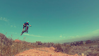
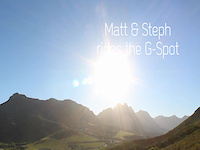
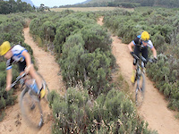
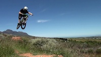
SaveThe G-Spot trail is a rad user friendly trail. A place with awesum flow and lines. Fun berms and jumps and routes to ride. Ride at own risk. Be safe.Look out for other riders and people on the trail . Wear your helmet and enjoy the ride.
For more information follow the links below to The G-Spot Website & Facebook Page.
The G-spot was built by Mark Gordon a good few years ago, with the vision that it would bring riders together from all over Stellenbosch and give them a fun environment to ride and improve their skills.
Mark is an experienced trail builder and you can get in touch with him if you would like to have a trail built in your area. Chat to him about pricing and other info through the Facebook page
G-spot is home to some of the area’s most hotly contested strava segments. People from all over the world come to train in this remarkable environment that the Western Cape has to offer, and with some of the country’s best single track on offer, it’s no wonder they keep coming back.
source: G-Spot Website
Primary Trail Type: Cross-Country
Land Status: City Managed
 google parking directions
 Access Info:
Step 1: Head straight past Paul Roos Kwikspar (on your right) whilst heading away from town. The road you're on is Piet Retief Street.
Step 2: Continue straight up the steep hill on Piet Retief Street and turn right at the T-Junction next to the residential park.
Step 3: After turning right at the park. Continue straight and take your 2nd left onto Kronendal Road. This road is another steep hill and once you reach the top you will see a gravel car park on your left.
The gravel car park is located at 13 Nooitgedacht Street. Enter through the gate on the right hand side of the car park and start exploring! Please read the signs to know where not to ride up and where to come down on the trail itself.
Disclaimer:
Free access. The trails have been built to allow riders of all skill levels to enjoy a fun and flowing ride. If you would like to see more epic trails get built at G-spot and around Stellies, contact Mark at [email protected] and help him out!
Links
Files
Activities Click to view
- Mountain Bike
16 trails
- E-Bike
6 trails
- Hike
13 trails
- Trail Running
13 trails
Region Details
- 6
- 6
- 3
Region Status
Open as of Feb 17, 2026Stats
- Avg Trail Rating
- Trails (view details)
- 16
- Trails Mountain Bike
- 17
- Trails E-Bike
- 6
- Trails Hike
- 13
- Trails Trail Running
- 13
- Total Distance
- 8 miles
- Total Descent Distance
- 3 miles
- Total Descent
- 1,385 ft
- Total Vertical
- 512 ft
- Highest Trailhead
- 1,046 ft
- Reports
- 470
- Photos
- 48
- Ridden Counter
- 6,801
Popular STF G-Spot Mountain Biking Trails
• 100 ★ 3.5 • 692 ft • 108 ft • 830 •
Popular green difficulty singletrack. This mountain bike primary trail can be used uphill primary and has a easy overall physical rating with a 108 ft blue climb. It features berm and jump. Trail visibility is always easy to follow. On average it takes minutes to complete this trail.
• 100 ★ 4.0 • 3,287 ft • 44 ft • 768 •
Popular green difficulty singletrack. This multi-use trail can be used both directions. On average it takes 3 minutes to complete this trail.
• 100 ★ 4.5 • 1,765 ft • 7 ft • 647 •
Popular blue difficulty singletrack. This mountain bike primary trail can be used downhill only and has a moderate overall physical rating. It features berm, drop, jump and gap jump. Trail visibility is always easy to follow. On average it takes 1 minutes to complete this trail.
• 95 ★ 3.0 • 1,493 ft • 24 ft • 494 •
Popular green difficulty singletrack. This mountain bike primary trail can be used both directions and has a easy overall physical rating with a 24 ft green climb. It features berm, jump and gap jump. Trail visibility is always easy to follow. On average it takes 2 minutes to complete this trail.
• 95 ★ 4.0 • 322 ft • 0 ft • 408 •
Popular blue difficulty singletrack. This mountain bike primary trail can be used downhill only and has a easy overall physical rating with a 0 ft blue climb. Trail visibility is always easy to follow. On average it takes minutes to complete this trail.
• 85 ★ 4.9 • 1 mile • 15 ft • 407 •
The trail was built about 5 yrs ago by Trail builder Mark G. I built this trail to be a place to train and have fun with my friends . Its a great spot to progress ur riding skillz. Its a fun easy trail to ride . For all ages and skill...
• 95 ★ 4.0 • 860 ft • 71 ft • 403 •
Popular green difficulty singletrack. This multi-use trail can be used uphill primary. On average it takes 1 minutes to complete this trail.
STF G-Spot Mountain Bike Routes
2 miles • 437 ft • 4 • Loop •
Circular route from G-Spot parking to the top of G-Spot and all the way down.
Photos of STF G-Spot Mountain Bike
Videos of STF G-Spot Mountain Bike
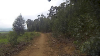
trail: G-Spot Main Line
0:34 |
245 |
Oct 15, 2017
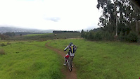
trail: G-Spot Main Line
2:07 |
2726 |
Dec 11, 2013
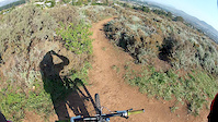
trail: G-Spot Main Line
0:15 |
463 |
Dec 9, 2013
trail: G-Spot Main Line
4:00 |
983 |
Nov 19, 2013
trail: G-Spot Main Line
3:13 |
586 |
Jul 21, 2013
trail: G-Spot Main Line
3:40 |
234 |
Jun 26, 2012
trail: G-Spot Main Line
0:02 |
259 |
Jun 18, 2012
youtuber
![Chasing locals in Stellenbosch South Africa //...]()

5:08 |
89 |
Jan 23, 2025
Recent Trail Reports
| status | trail | date | condition | info | user |
|---|---|---|---|---|---|
| G-Spot Alternative Line | Feb 17, 2026 @ 11:11pm (Africa/Johannesburg) Feb 17, 2026 | Ideal | moniera | ||
| Alternative Climb to G-Spot | Feb 15, 2026 @ 9:25am (Africa/Maseru) Feb 14, 2026 | Very Dry | theampedlife | ||
| G-Spot Main Line | Feb 15, 2026 @ 1:33pm (Africa/Johannesburg) Feb 15, 2026 | Ideal | moniera | ||
| Coetzenburg - G-Spot - Eden Top Link | Nov 2, 2025 @ 1:25pm (Africa/Johannesburg) Nov 2, 2025 | Dry | theampedlife | ||
| G-Spot - Eden Bottom Link | Mar 25, 2025 @ 5:15pm Mar 25, 2025 | Ideal | theampedlife | ||
| Connector4 | Mar 17, 2025 @ 10:08am Mar 17, 2025 | Ideal | BestWhistler | ||
| G Spot Single Track Climb | Mar 17, 2025 @ 10:08am Mar 17, 2025 | Ideal | BestWhistler | ||
| Connector | Mar 17, 2025 @ 10:08am Mar 17, 2025 | Dry | BestWhistler | ||
| G-Spot Road (south) | Oct 25, 2024 @ 5:31pm Oct 25, 2024 | Very Dry | theampedlife | ||
| Contour Road | Oct 25, 2024 @ 5:31pm Oct 25, 2024 | Dry | theampedlife |
Activity Feed
| username | action | type | title | date |
|---|---|---|---|---|
| SagezgRfxY | wishlist | trail | activity #93171088 | Apr 22, 2026 @ 1:59pm Apr 22, 2026 |
| S56WBV | wishlist | trail | activity #91012595 | Mar 21, 2026 @ 12:02pm Mar 21, 2026 |
| theampedlife | vote | trail | activity #90271181 | Mar 9, 2026 @ 9:46am Mar 9, 2026 |
| moniera | add | report | activity #89090883 | Feb 17, 2026 @ 1:11pm Feb 17, 2026 |
| theampedlife | add | report | activity #88950758 | Feb 15, 2026 @ 5:18am Feb 15, 2026 |
Recent Comments
| username | type | title | comment | date |
|---|---|---|---|---|
| trail | Still one of the best places to have fun!... | Aug 25, 2020 @ 4:15am Aug 25, 2020 | ||
| trail | G-spot is one of the most awesome trails.... | May 19, 2016 @ 2:44am May 19, 2016 | ||
| trail | G-spot is one of the most awesome trails.... | May 19, 2016 @ 2:44am May 19, 2016 |
Nearby Areas
| name | distance | ||||
|---|---|---|---|---|---|
| STF Coetzenburg | 1 | 5 | 1 | 0.9 km | |
| STF Eden / Paradyskloof | 9 | 1 | 0.9 km | ||
| STF Koloniesland | 3 | 1.1 km | |||
| STF Mont Marie | 3 | 5 | 1.8 km | ||
| STF Botmaskop | 4 | 7 | 2.4 km |
Activity Type Stats
| activitytype | trails | distance | descent | descent distance | total vertical | rating | global rank | state rank | photos | reports | routes | ridelogs |
|---|---|---|---|---|---|---|---|---|---|---|---|---|
| Mountain Bike | 16 | 8 miles | 1,378 ft | 3 miles | 512 ft | #2,704 | #56 | 48 | 484 | 1 | 5,824 | |
| E-Bike | 6 | 2 miles | 115 ft | 3,563 ft | 394 ft | #4,723 | #191 | 460 | 1 | 599 | ||
| Hike | 13 | 6 miles | 712 ft | 2 miles | 512 ft | #7,971 | #196 | 474 | 72 | |||
| Trail Running | 13 | 6 miles | 712 ft | 2 miles | 512 ft | #6,327 | #179 | 474 | 1,002 |
Frequently Asked Questions About STF G-Spot
▼
What are the highest rated mountain biking trails in STF G-Spot?
The highest rated mountain biking trails in STF G-Spot are:
- G-Spot Main Line (4.5/5)
- G-Spot Alternative Line (4.2/5)
- G-Spot - Eden Bottom Link (4/5)
- Coetzenburg - G-Spot - Eden Top Link (4/5)
- Climb from Tikbos to G-Spot (4/5)
▼
What is the best time of the year to ride in STF G-Spot?
Based on ride log data, the most popular months to ride in STF G-Spot are:
- February (14 activities)
- October (14 activities)
- July (13 activities)
▼
Where can I park to ride in STF G-Spot?
There are 1 parking locations listed in STF G-Spot. The most popular parking spots are:
▼
What is the longest trail in STF G-Spot?
The longest trail in STF G-Spot is G-Spot Main Line at 2.1 km. View all trails sorted by distance.
Activities
- By wesseljacobsz
 TRAILFORKS WAM SBP SWW & contributors
 - Admins: STF
- #37365 - 5,814 views
- stf g-spot activity log | embed map of STF G-Spot mountain bike trails | stf g-spot mountain biking points of interest
Downloading of trail gps tracks in kml & gpx formats is enabled for STF G-Spot.
You must login to download files.