close
-
Layers w
- Weather Layers
- Pro
- Pro
- Pro
- Pro
- Pro
- Pro
- More Layers
- Pro
- Pro
- Pro
- Pro
-
Upgrade to

3D
Trail Conditions
- Unknown
- Snow Groomed
- Snow Packed
- Snow Covered
- Snow Cover Partial
- Freeze/thaw Cycle
- Icy
- Prevalent Mud
- Wet
- Variable
- Ideal
- Dry
- Very Dry
Trail Flow (Ridden Direction)
Trailforks scans users ridelogs to determine the most popular direction each trail is ridden. A good flowing trail network will have most trails flowing in a single direction according to their intension.
The colour categories are based on what percentage of riders are riding a trail in its intended direction.
The colour categories are based on what percentage of riders are riding a trail in its intended direction.
- > 96%
- > 90%
- > 80%
- > 70%
- > 50%
- < 50%
- bi-directional trail
- no data
Trail Last Ridden
Trailforks scans ridelogs to determine the last time a trail was ridden.
- < 2 days
- < 1 week
- < 2 weeks
- < 1 month
- < 6 months
- > 6 months
Trail Ridden Direction
The intended direction a trail should be ridden.
- Downhill Only
- Downhill Primary
- Both Directions
- Uphill Primary
- Uphill Only
- One Direction
Contribute Details
Colors indicate trail is missing specified detail.
- Description
- Photos
- Description & Photos
- Videos
Trail Popularity ?
Trailforks scans ridelogs to determine which trails are ridden the most in the last 9 months.
Trails are compared with nearby trails in the same city region with a possible 25 colour shades.
Think of this as a heatmap, more rides = more kinetic energy = warmer colors.
- most popular
- popular
- less popular
- not popular
ATV/ORV/OHV Filter
Max Vehicle Width
inches
US Cell Coverage
Legend

Radar Time
Activity Recordings
Trailforks uses anonymized public activity data.
?
Activity Recordings
Trailforks uses anonymized public activity data.
?
Personal Heatmap
▶
Activity Types
all
/
none
▶
Options
2
Date range
month
–
Winter Trails
Warning
A routing network for winter maps does not exist. Selecting trails using the winter trails layer has been disabled.
Missing Trails
Most Popular
Least Popular
Trails are colored based on popularity. The more popular a trail is, the more red. Less popular trails trend towards green.
Jump Magnitude Heatmap
Heatmap of where riders jump on trails. Zoom in to see individual jumps, click circles to view jump details.
BC Backroad Status
![map legend]()
Service Road Atlas is a free to use, community-driven service for viewing and creating reports on the numerous back-country service roads around B.C. and Alberta.

Slope Aspect
Direction the slope faces
Trails Deemphasized
Trails are shown in grey.
Only show trails with no bike usage.
Suggested Layers
Based on selected activity type
Save the current map location and zoom level as your default home location whenever this page is loaded.
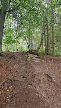
SaveLocated on Cannock Chase in the Midlands, Stile Cop is home to a small selection of excellent downhill trails with a vibrant local community. With a total height drop of just 65 metres the trails are limited to around a one minute run, but there’s a wide variety to keep riders busy. The trails are free to ride and open all year round.
Stile Cop is also home to the Racers Guild downhill races - these are a great opportunity for both new and seasoned riders to give downhill racing a go. For upcoming dates and for more information, visit the Racers Guild Racing Facebook group.
Watch out for trail closures due to maintenance or emergency issues. Full face helmets and suitable body armour are highly recommended. Always check the trails out on foot before hitting them at speed.
Construction of the official trail network began in 2003 and Chase Trails looked after the hill from 2004 to 2015. In early 2016, the Racers Guild team took over and work with the Forestry Commission and Chase Trails to build and maintain the trails.
source: Stile Cop
Primary Trail Type: All-Mountain & Downhill
eBikes Allowed:
Yes
Land Status: National Forest
Land Manager: Forestry England
 google parking directions
 Access Info:
Parking is available at the Stile Cop Car Park, just off Stile Cop Road. You can also park next to the main entrance gate (please don't block the gate).
Links
- Forestry England (Landowner)
- Stile Cop DH Trails (Official MTB Trail Builders & Trail Info)
- Racers Guild Facebook Group (Local Riding Community)
- Chase Trails (Official MTB Trail Builders)
This region uses the Uk/Euro style trail grading system.
Region Supporters & Maintainers
![]()
Chase Trails
2004 - 2015Builder
Activities Click to view
- Mountain Bike
30 trails
- E-Bike
30 trails
- Horse
18 trails
- Hike
18 trails
- Trail Running
18 trails
- Observed Trials
0 trails
Region Details
- 18
- 2
- 5
- 5
Region Status
Open as of Jun 7, 2026Local Trail Association
Stats
- Avg Trail Rating
- Trails (view details)
- 30
- Trails Mountain Bike
- 30
- Trails E-Bike
- 30
- Trails Horse
- 18
- Trails Hike
- 18
- Trails Trail Running
- 18
- Total Distance
- 10 miles
- Total Descent
- 3,289 ft
- Total Vertical
- 354 ft
- Highest Trailhead
- 735 ft
- Reports
- 326
- Photos
- 4,459
- Ridden Counter
- 9,246
Popular Stile Cop Mountain Biking Trails
• 70 ★ 4.2 • 1,437 ft • 0 ft • 737 •
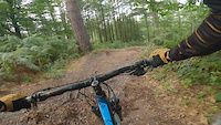
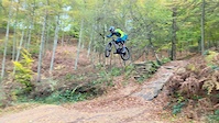
Open, fast and fun. Full speed all the way into sweeping corners, nice jumps with a series of tight and twisty corners towards the finish. Head straight over a short sharp root section into a neat drop through a tree to finish.
• 65 ★ 4.6 • 2,290 ft • 17 ft • 731 •
A smooth, wide, fast and flowing course. The original official course on the hill is aimed at intermediate riders with a series of drops and jumps all the way to the bottom. a good warm up for your first run although watch the carpet of...
• 80 ★ 4.4 • 677 ft • 2 ft • 664 •
A pumpstastic, jumptastic playground. Break off at the gas line and get ready to smile as you hit the flowing and progressive jumps and berms finishing with the Wallride.
• 65 ★ 4.5 • 923 ft • 9 ft • 658 •
Start on the and break left, off-camber corners and roots, things start to get trickier on this line.
• 60 ★ 4.7 • 1,545 ft • 0 ft • 640 •
Starting on the same platform as the the Black is a narrow singletrack line on one of the flatter parts of the hill. A series of small jumps, drops and rock gardens take you down the hill. Some sticky off camber sections and a steeper...
• 65 ★ 4.4 • 678 ft • 9 ft • 613 •
Opened in September 2012 after a long closure for upgrading & rebuilding. is the biggest trail on the hill and is a test for the best riders. Built with a more freeride feel the trail starts with a rock backed double into a short steep...
• 60 ★ 3.8 • 826 ft • 0 ft • 581 •
First left option off the , to start it gets tighter and steeper then the . The over the ‘gas line’ and into some off camber roots and flatter corners. Drop off the tree stump and into a fast rooty rattle. Jump towards the fire road...
Stile Cop Mountain Bike Routes
1,243 ft • 2 • Point to Point • Race •
Race route for the Racers Guild Racing events. - uses the top half of then splits left onto just before...
1,125 ft • 2 • Point to Point • Race •
Race route for the Racers Guild Racing events. New Line.
1,598 ft • 1 • Point to Point • Race •
Race route for the Racers Guild Racing events. Black Course.
1,194 ft • 2 • Point to Point • Race •
Race route for the Racers Guild Racing events. Wonderland.
1,417 ft • 2 • Point to Point • Race •
Race route for the Racers Guild Racing events. Ridge Run.
2,477 ft • 26 ft • 2 • Point to Point • Race •
Race route for the Racers Guild Racing events. Red Course.
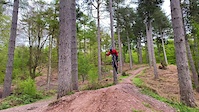
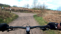
Photos of Stile Cop Mountain Bike
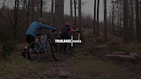
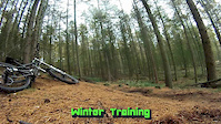
Videos of Stile Cop Mountain Bike
trail: Ridge Run
0:08 |
121 |
Sep 2, 2023
trail: Ridge Run
0:07 |
84 |
Sep 30, 2022
trail: Red Course
3:20 |
144 |
Apr 8, 2022
trail: Black Course
2:39 |
145 |
Aug 16, 2021
trail: Red Course
0:19 |
118 |
May 12, 2021
trail: Balboa
0:08 |
178 |
Mar 10, 2021
trail: Ridge Run
0:55 |
143 |
Jul 16, 2020
trail: Black Course
0:37 |
390 |
Mar 28, 2020
Recent Trail Reports
| status | trail | date | condition | info | user |
|---|---|---|---|---|---|
| Access Trail | Mar 8, 2026 @ 11:27am (Europe/London) Mar 8, 2026 | Ideal | Mtbtrailrider70 | ||
| New Line | Mar 8, 2026 @ 11:27am (Europe/London) Mar 8, 2026 | Ideal | Mtbtrailrider70 | ||
| Mega Trail | Mar 8, 2026 @ 11:27am (Europe/London) Mar 8, 2026 | Ideal | Mtbtrailrider70 | ||
| Stile Cop Access Road | Mar 8, 2026 @ 11:27am (Europe/London) Mar 8, 2026 | Variable | Mtbtrailrider70 | ||
| Ridge Run | Mar 8, 2026 @ 11:27am (Europe/London) Mar 8, 2026 | Variable | Mtbtrailrider70 | ||
| Red Course | May 3, 2025 @ 11:56am May 3, 2025 | Ideal | Tedacuz1 | ||
| Snakes ‘n Ladders | Oct 14, 2024 @ 12:20pm Oct 14, 2024 | Wet | alandc | ||
| CDL | Oct 14, 2024 @ 12:20pm Oct 14, 2024 | Variable | alandc | ||
| Little Bringe | Jun 14, 2024 @ 2:27am Jun 14, 2024 | Ideal | p1ngymtb | ||
| Balboa | Jun 14, 2024 @ 2:27am Jun 14, 2024 | Ideal | p1ngymtb |
Activity Feed
| username | action | type | title | date |
|---|---|---|---|---|
| trailforks | add | video | activity #97603337 | Jun 22, 2026 @ 9:00pm 18 hours |
| trailforks | add | video | activity #96811702 | Jun 12, 2026 @ 10:11am Jun 12, 2026 |
| trailforks | add | video | activity #95666910 | May 27, 2026 @ 4:00pm May 27, 2026 |
| trailforks | add | video | activity #95646894 | May 27, 2026 @ 11:00am May 27, 2026 |
| trailforks | add | video | activity #95330482 | May 23, 2026 @ 10:00am May 23, 2026 |
Recent Comments
| username | type | title | comment | date |
|---|---|---|---|---|
| trail | Unless you are at style cop for the really big... | Jun 3, 2023 @ 4:29am Jun 3, 2023 | ||
| trail | Fun fast decent for the novice all the way to... | Oct 5, 2014 @ 12:27pm Oct 5, 2014 |
Nearby Areas
| name | distance | ||||
|---|---|---|---|---|---|
| Cannock Chase | 2 | 13 | 1.6 km | ||
| Blithfield Reservoir | 5.8 km | ||||
| Hopwas Woods | 2 | 10.5 km | |||
| Sandwell Valley | 14.2 km | ||||
| Pooley Country Park | 2 | 1 | 15.3 km |
Activity Type Stats
| activitytype | trails | distance | descent | descent distance | total vertical | rating | global rank | state rank | photos | reports | routes | ridelogs |
|---|---|---|---|---|---|---|---|---|---|---|---|---|
| Mountain Bike | 30 | 10 miles | 3,287 ft | 6 miles | 354 ft | #2,826 | #90 | 4,459 | 326 | 8 | 4,008 | |
| E-Bike | 30 | 10 miles | 3,287 ft | 6 miles | 354 ft | #2,992 | #106 | 300 | 649 | |||
| Horse | 18 | 7 miles | 1,371 ft | 4 miles | 354 ft | #1,035 | #48 | 119 | ||||
| Hike | 18 | 7 miles | 1,371 ft | 4 miles | 354 ft | #8,267 | #205 | 299 | 38 | |||
| Trail Running | 18 | 7 miles | 1,371 ft | 4 miles | 354 ft | #7,415 | #186 | 299 | 48 |
Frequently Asked Questions About Stile Cop
▼
What are the highest rated mountain biking trails in Stile Cop?
The highest rated mountain biking trails in Stile Cop are:
- Black Course (4.4/5)
- Balboa (4.4/5)
- Red Course (4.3/5)
- Little Bringe (4.2/5)
- New Line (4.2/5)
▼
What is the best time of the year to ride in Stile Cop?
Based on ride log data, the most popular months to ride in Stile Cop are:
- July (15 activities)
- May (11 activities)
- August (9 activities)
▼
Where can I park to ride in Stile Cop?
There are 2 parking locations listed in Stile Cop. The most popular parking spots are:
▼
What is the longest trail in Stile Cop?
The longest trail in Stile Cop is Red Course at 2,290 ft. View all trails sorted by distance.
Activities
Trails
- By brenthillier
 NSMBA TRAILFORKS & contributors
 - Admins: Chase Trails
- #4681 - 19,790 views
- stile cop activity log | embed map of Stile Cop mountain bike trails | stile cop mountain biking points of interest
Downloading of trail gps tracks in kml & gpx formats is enabled for Stile Cop.
You must login to download files.