close
-
Layers w
- Weather Layers
- Pro
- Pro
- Pro
- Pro
- Pro
- Pro
- More Layers
- Pro
- Pro
- Pro
- Pro
-
Upgrade to

3D
Trail Conditions
- Unknown
- Snow Groomed
- Snow Packed
- Snow Covered
- Snow Cover Partial
- Freeze/thaw Cycle
- Icy
- Prevalent Mud
- Wet
- Variable
- Ideal
- Dry
- Very Dry
Trail Flow (Ridden Direction)
Trailforks scans users ridelogs to determine the most popular direction each trail is ridden. A good flowing trail network will have most trails flowing in a single direction according to their intension.
The colour categories are based on what percentage of riders are riding a trail in its intended direction.
The colour categories are based on what percentage of riders are riding a trail in its intended direction.
- > 96%
- > 90%
- > 80%
- > 70%
- > 50%
- < 50%
- bi-directional trail
- no data
Trail Last Ridden
Trailforks scans ridelogs to determine the last time a trail was ridden.
- < 2 days
- < 1 week
- < 2 weeks
- < 1 month
- < 6 months
- > 6 months
Trail Ridden Direction
The intended direction a trail should be ridden.
- Downhill Only
- Downhill Primary
- Both Directions
- Uphill Primary
- Uphill Only
- One Direction
Contribute Details
Colors indicate trail is missing specified detail.
- Description
- Photos
- Description & Photos
- Videos
Trail Popularity ?
Trailforks scans ridelogs to determine which trails are ridden the most in the last 9 months.
Trails are compared with nearby trails in the same city region with a possible 25 colour shades.
Think of this as a heatmap, more rides = more kinetic energy = warmer colors.
- most popular
- popular
- less popular
- not popular
ATV/ORV/OHV Filter
Max Vehicle Width
inches
US Cell Coverage
Legend

Radar Time
Activity Recordings
Trailforks uses anonymized public activity data.
?
Activity Recordings
Trailforks uses anonymized public activity data.
?
Personal Heatmap
▶
Activity Types
all
/
none
▶
Options
2
Date range
month
–
Winter Trails
Warning
A routing network for winter maps does not exist. Selecting trails using the winter trails layer has been disabled.
Missing Trails
Most Popular
Least Popular
Trails are colored based on popularity. The more popular a trail is, the more red. Less popular trails trend towards green.
Jump Magnitude Heatmap
Heatmap of where riders jump on trails. Zoom in to see individual jumps, click circles to view jump details.
BC Backroad Status
![map legend]()
Service Road Atlas is a free to use, community-driven service for viewing and creating reports on the numerous back-country service roads around B.C. and Alberta.

Slope Aspect
Direction the slope faces
Trails Deemphasized
Trails are shown in grey.
Only show trails with no bike usage.
Suggested Layers
Based on selected activity type
Save the current map location and zoom level as your default home location whenever this page is loaded.
Save
No description for Stormsrivier has been added yet!
Login or register to submit one.
Links
Activities Click to view
- Mountain Bike
16 trails
- E-Bike
7 trails
- Hike
77 trails
- Trail Running
79 trails
Region Details
- 13
- 3
Region Status
Open as of Jan 25, 2025Stats
- Avg Trail Rating
- Trails (view details)
- 55
- Trails Mountain Bike
- 16
- Trails E-Bike
- 7
- Trails Hike
- 79
- Trails Trail Running
- 79
- Trails Dirtbike/Moto
- 1
- Total Distance
- 138 miles
- Total Descent Distance
- 61 miles
- Total Descent
- 19,404 ft
- Total Vertical
- 2,356 ft
- Highest Trailhead
- 2,356 ft
- Reports
- 21
- Photos
- 26
- Ridden Counter
- 1,261
Sub Regions
-
Garden Route National Park
- 1
-
Misty Mountain Reserve
Popular Stormsrivier Mountain Biking Trails
• 90 ★ 0.0 • 3 miles • 392 ft • 64 •
Popular green difficulty doubletrack. This mountain bike primary trail can be used both directions and has a easy overall physical rating with a 392 ft blue climb. Trail visibility is always easy to follow. On average it takes 22 minutes to complete this trail.
• 65 ★ 0.0 • 2 miles • 24 ft • 10 •
Moderately popular green difficulty asphalt/tarmac road. This mountain bike primary trail can be used both directions and has a moderate overall physical rating with a 24 ft blue climb. Trail visibility is always easy to follow. On average it takes 4 minutes to complete this trail.
• 35 ★ 0.0 • 2 miles • 156 ft • 4 •
Less popular green difficulty family friendly dirt/gravel road. This mountain bike primary trail can be used both directions and has a easy overall physical rating with a 156 ft green climb. Trail visibility is always easy to follow. On average it takes 17 minutes to complete this trail.
Stormsrivier Mountain Bike Routes
MMR Black Route Featured
★ 1.0 • 39 miles • 2,364 ft • 3 • Loop •
The black route is the route that caters for the fit mountain biker looking for some good testing distance...
9 miles • 320 ft • 1 • Out & Back •
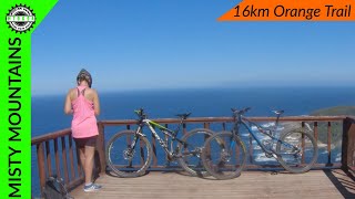
The orange route is 15km long and also very easy. It takes you out on the gravel roads, and then down...
6 miles • 201 ft • 1 • Loop •
The yellow route is just under 9km long and very easy. It is the perfect route for the couple who do not...
21 miles • 2,378 ft • 0 • Out & Back •
The blue route requires some cycling fitness. It basically follows the other routes out of MMR, through a...
Photos of Stormsrivier Mountain Bike
Videos of Stormsrivier Mountain Bike
6:23 |
300 |
May 18, 2021
Recent Trail Reports
| status | trail | date | condition | info | user |
|---|---|---|---|---|---|
| Fernery access road | Jan 25, 2025 @ 8:02am Jan 25, 2025 | Variable | RobinOlbrich | ||
| Natures Lookout to Covie | Nov 22, 2023 @ 9:31pm Nov 22, 2023 | Very Dry | PaulApplewhite | ||
| MMR Orange Forestry Road | Aug 6, 2022 @ 3:18am Aug 6, 2022 | Ideal | TanyaJackson | ||
| Storms River Pass | Dec 28, 2021 @ 11:06pm Dec 28, 2021 | Ideal | minkels | ||
| MMR BR connect | Dec 28, 2021 @ 11:06pm Dec 28, 2021 | Unknown | minkels | ||
| Misty Mountain Reserve Access road | Dec 28, 2021 @ 11:06pm Dec 28, 2021 | Ideal | minkels | ||
| Access to Fernery loop | Dec 28, 2021 @ 11:05pm Dec 28, 2021 | Ideal | minkels | ||
| Misty Mountain Loop | Aug 7, 2021 @ 3:09am Aug 7, 2021 | Ideal | TanyaJackson |
Activity Feed
| username | action | type | title | date |
|---|---|---|---|---|
| mindre | wishlist | region | activity #78670916 | Aug 22, 2025 @ 6:39am Aug 22, 2025 |
| RobinOlbrich | add | report | activity #65193568 | Jan 25, 2025 @ 9:25pm Jan 25, 2025 |
| andrejvvza | vote | route | activity #64034775 | Jan 3, 2025 @ 11:14pm Jan 3, 2025 |
| andrejvvza | ridden | trail | activity #63986207 | Jan 2, 2025 @ 10:50pm Jan 2, 2025 |
| Jsrogoff | ridden | route | activity #63871650 | Dec 31, 2024 @ 9:07pm Dec 31, 2024 |
Local Badges
-

Epic Ride Descent 2k17 awarded -

Descent 10k Badge9 awarded -

Descent 100k Badge0 awarded -

Epic Mountain Bike Climb 2k8 awarded -

Climbing 10k Badge6 awarded -

Mountain Biking 100k Badge0 awarded
Activity Type Stats
| activitytype | trails | distance | descent | descent distance | total vertical | rating | global rank | state rank | photos | reports | routes | ridelogs |
|---|---|---|---|---|---|---|---|---|---|---|---|---|
| Mountain Bike | 16 | 63 miles | 4,173 ft | 29 miles | 1,122 ft | #3,503 | #64 | 21 | 21 | 4 | 1,000 | |
| E-Bike | 7 | 28 miles | 2,300 ft | 16 miles | 1,122 ft | #3,795 | #138 | 2 | 21 | 3 | 205 | |
| Hike | 77 | 138 miles | 19,403 ft | 61 miles | 2,356 ft | #1,518 | #44 | 3 | 21 | 3 | 584 | |
| Trail Running | 79 | 138 miles | 19,403 ft | 61 miles | 2,356 ft | #1,255 | #44 | 21 | 3 | 118 | ||
| Dirtbike/Moto | 1 | 2 miles | 30 ft | 2,382 ft | 131 ft | 1 |
Frequently Asked Questions About Stormsrivier
▼
What are the best places to ride in Stormsrivier?
Stormsrivier has 2 areas to explore for mountain biking. The top rated areas are:
▼
What are the highest rated mountain biking trails in Stormsrivier?
The highest rated mountain biking trails in Stormsrivier are:
- Kleinbos Indigenous (0/5)
- Storms River Mouth (0/5)
- Natures Lookout to Covie (0/5)
▼
What is the best time of the year to ride in Stormsrivier?
Based on ride log data, the most popular months to ride in Stormsrivier are:
- February (4 activities)
- July (4 activities)
- November (3 activities)
▼
Where can I park to ride in Stormsrivier?
Activities
Trails
- By WillieJacobsz
 Trailforks SBP SWW & contributors
 - Admins: Cape, irideafrica
- #37946 - 2,414 views
- stormsrivier activity log | embed map of Stormsrivier mountain bike trails | stormsrivier mountain biking points of interest
Downloading of trail gps tracks in kml & gpx formats is enabled for Stormsrivier.
You must login to download files.