close
-
Layers w
- Weather Layers
- Pro
- Pro
- Pro
- Pro
- Pro
- Pro
- More Layers
- Pro
- Pro
- Pro
- Pro
-
Upgrade to

3D
Trail Conditions
- Unknown
- Snow Groomed
- Snow Packed
- Snow Covered
- Snow Cover Partial
- Freeze/thaw Cycle
- Icy
- Prevalent Mud
- Wet
- Variable
- Ideal
- Dry
- Very Dry
Trail Flow (Ridden Direction)
Trailforks scans users ridelogs to determine the most popular direction each trail is ridden. A good flowing trail network will have most trails flowing in a single direction according to their intension.
The colour categories are based on what percentage of riders are riding a trail in its intended direction.
The colour categories are based on what percentage of riders are riding a trail in its intended direction.
- > 96%
- > 90%
- > 80%
- > 70%
- > 50%
- < 50%
- bi-directional trail
- no data
Trail Last Ridden
Trailforks scans ridelogs to determine the last time a trail was ridden.
- < 2 days
- < 1 week
- < 2 weeks
- < 1 month
- < 6 months
- > 6 months
Trail Ridden Direction
The intended direction a trail should be ridden.
- Downhill Only
- Downhill Primary
- Both Directions
- Uphill Primary
- Uphill Only
- One Direction
Contribute Details
Colors indicate trail is missing specified detail.
- Description
- Photos
- Description & Photos
- Videos
Trail Popularity ?
Trailforks scans ridelogs to determine which trails are ridden the most in the last 9 months.
Trails are compared with nearby trails in the same city region with a possible 25 colour shades.
Think of this as a heatmap, more rides = more kinetic energy = warmer colors.
- most popular
- popular
- less popular
- not popular
ATV/ORV/OHV Filter
Max Vehicle Width
inches
US Cell Coverage
Legend

Radar Time
Activity Recordings
Trailforks uses anonymized public activity data.
?
Activity Recordings
Trailforks uses anonymized public activity data.
?
Personal Heatmap
▶
Activity Types
all
/
none
▶
Options
2
Date range
month
–
Winter Trails
Warning
A routing network for winter maps does not exist. Selecting trails using the winter trails layer has been disabled.
Missing Trails
Most Popular
Least Popular
Trails are colored based on popularity. The more popular a trail is, the more red. Less popular trails trend towards green.
Jump Magnitude Heatmap
Heatmap of where riders jump on trails. Zoom in to see individual jumps, click circles to view jump details.
BC Backroad Status
![map legend]()
Service Road Atlas is a free to use, community-driven service for viewing and creating reports on the numerous back-country service roads around B.C. and Alberta.

Slope Aspect
Direction the slope faces
Trails Deemphasized
Trails are shown in grey.
Only show trails with no bike usage.
Suggested Layers
Based on selected activity type
Save the current map location and zoom level as your default home location whenever this page is loaded.
Save
No description for St-Philémon has been added yet!
Login or register to submit one.
Activities Click to view
- Mountain Bike
0 trails
- E-Bike
54 trails
- Gravel Bike
0 trails
- Adaptive Bike
0 trails
- Winter Fat Bike
0 trails
- Hike
32 trails
- Trail Running
32 trails
- Snowshoe
9 trails
- Downhill Ski
32 trails
- Backcountry Ski
10 trails
- Nordic Ski
12 trails
Region Details
- 1
- 20
- 41
- 14
- 5
Region Status
Open as of May 21, 2026Local Trail Association
Stats
- Avg Trail Rating
- Trails (view details)
- 126
- Trails Mountain Bike
- 56
- Trails E-Bike
- 54
- Trails Hike
- 32
- Trails Trail Running
- 32
- Trails Snowshoe
- 9
- Trails Downhill Ski
- 32
- Trails Backcountry Ski
- 10
- Trails Nordic Ski
- 12
- Total Distance
- 73 miles
- Total Descent Distance
- 42 miles
- Total Descent
- 25,919 ft
- Total Vertical
- 1,550 ft
- Highest Trailhead
- 2,994 ft
- Reports
- 628
- Photos
- 59
- Ridden Counter
- 4,002
Sub Regions
-
Parc du Massif du Sud
- 13
- 21
- 9
-
Station Touristique Massif du Sud
- 7
- 20
- 5
- 5
Popular St-Philémon Mountain Biking Trails
• 90 ★ 4.0 • 3,196 ft • 138 ft • 165 •
------------------------Scroll down for English version --------------------------- Origine du nom : ce sentier tire son nom du fait que pendant son aménagement, la surface du sentier était presque quotidiennement abimée par des...
• 100 ★ 3.0 • 2,064 ft • 49 ft • 158 •
Scroll down for English version Origine du nom : Le sentier a été aménagé dans le but de relier 2 sentiers. Une connexion entre deux sentiers…on aurait pu l’appeler ''Le Troisième Lien'' ou ''Le Cordon Ombilical''…mais on a...
• 95 ★ 3.5 • 2,920 ft • 148 ft • 155 •
------------------------Scroll down for English version --------------------------- Origine du nom : ce sentier tire son nom du fait qu’il monte graduellement sur toute sa longueur, et qu’il est le premier sentier du réseau. Il...
• 95 ★ 4.5 • 1 mile • 42 ft • 150 •
------------------------Scroll down for English version --------------------------- Origine du nom: En musique, les disques de type long jeu (33 tours) permettaient aux mélomanes de pouvoir écouter des albums de plus longue durée sur...
• 100 ★ 3.5 • 371 ft • 44 ft • 141 •
Popular blue difficulty family friendly singletrack. This mountain bike primary trail and has a moderate overall physical rating with a 44 ft blue climb. It features bridge. Trail visibility is always easy to follow. On average it takes 3 minutes to complete this trail.
• 60 ★ 4.5 • 4,370 ft • 105 ft • 128 •
-----------------------------------------------Scroll down for English version--------------------------------------------------------------- Origine du nom : ce sentier a été baptisé du fait que la longue descente finale requiert de...
• 75 ★ 4.0 • 2,123 ft • 36 ft • 127 •
------------------------------------------------------------Scroll down for English version------------------------------------------------- Origine du nom: Il n'y a pas de consensus concernant l'origine du nom . Certains prétendent...
• 65 ★ 4.5 • 1 mile • 198 ft • 124 •
----------------------------------------------------Scroll down for English version ------------------------------------------- Origine du nom : Le sentier recèle plusieurs montées et descentes, une courte section technique, ainsi que...
St-Philémon Mountain Bike Routes
La rouli-roulante Featured
7 miles • 998 ft • 12 • Loop •
Parcour roulant qui tente de balancer les montées et descentes, mais on en quand même au Parc, alors ça...
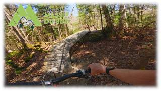
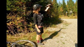
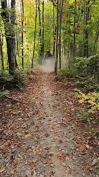
Photos of St-Philémon Mountain Bike
Videos of St-Philémon Mountain Bike
youtuber
![Un petit réseau peu connu mais pas mal trippant!]()
11:28 |
8 |
Jun 8, 2026
2:41 |
74 |
Sep 25, 2024

trail: Piste F (multifonctionnelle)
4:26 |
615 |
Jul 26, 2020 , St-Philémon
0:10 |
3 |
Aug 24, 2025
Recent Trail Reports
| status | trail | date | condition | info | user |
|---|---|---|---|---|---|
| Ma 1re Fois | May 21, 2026 @ 8:12pm (America/Toronto) May 21, 2026 | Variable | CaroPou LFDE | ||
| L̀a Chute à Vince | May 21, 2026 @ 8:12pm (America/Toronto) May 21, 2026 | Variable | CaroPou LFDE | ||
| Les Grandes Manoeuvres | May 21, 2026 @ 8:12pm (America/Toronto) May 21, 2026 | Variable | CaroPou LFDE | ||
| Le Transit-express - double sens | May 21, 2026 @ 8:12pm (America/Toronto) May 21, 2026 | Variable | CaroPou LFDE | ||
| Le Transit-express - descente | May 21, 2026 @ 8:12pm (America/Toronto) May 21, 2026 | Variable | CaroPou LFDE | ||
| Le Parloir | May 21, 2026 @ 8:12pm (America/Toronto) May 21, 2026 | Variable | CaroPou LFDE | ||
| Le long jeu | May 21, 2026 @ 8:12pm (America/Toronto) May 21, 2026 | Variable | CaroPou LFDE | ||
| Le chauffe-moteur | May 21, 2026 @ 8:12pm (America/Toronto) May 21, 2026 | Variable | CaroPou LFDE | ||
| La Trail du Veau | May 21, 2026 @ 8:12pm (America/Toronto) May 21, 2026 | Variable | CaroPou LFDE | ||
| La Trail du Buck | May 21, 2026 @ 8:12pm (America/Toronto) May 21, 2026 | Variable | CaroPou LFDE |
Activity Feed
| username | action | type | title | date |
|---|---|---|---|---|
| CaroPou | wishlist | trail | activity #97273209 | Jun 18, 2026 @ 1:28pm 2 days |
| CaroPou | add | trail | activity #97272213 and 29 more | Jun 18, 2026 @ 1:10pm 2 days |
| WillieJacobsz | update | region | activity #97269263 | Jun 18, 2026 @ 12:21pm 2 days |
| NicGuy | add | photo | activity #96960705 | Jun 14, 2026 @ 6:10am Jun 14, 2026 |
| NicGuy | ridden | trail | activity #96960566 and 7 more | Jun 14, 2026 @ 6:08am Jun 14, 2026 |
Recent Comments
| username | type | title | comment | date |
|---|---|---|---|---|
| trail | 6 is going down from the high point on both... | Sep 8, 2024 @ 7:47am Sep 8, 2024 | ||
| trail | La cerise sur le standard, belle façon de... | Jun 14, 2020 @ 1:09pm Jun 14, 2020 | ||
| trail | Fun loop, when added to Buck. Tighter... | Aug 15, 2017 @ 3:04pm Aug 15, 2017 | ||
| trail | Great Intermediate single track. Steady, ... | Aug 15, 2017 @ 3:00pm Aug 15, 2017 |
Local Badges
-

Epic Ride Climb 2k34 awarded -

Climbing 10k Badge3 awarded -

Climbing 100k Badge0 awarded -

Epic Ride Descent 2k34 awarded -

Descent 10k Badge4 awarded -

Descent 100k Badge0 awarded
Activity Type Stats
| activitytype | trails | distance | descent | descent distance | total vertical | rating | global rank | state rank | photos | reports | routes | ridelogs |
|---|---|---|---|---|---|---|---|---|---|---|---|---|
| E-Bike | 54 | 35 miles | 5,991 ft | 18 miles | 1,542 ft | #804 | #9 | 8 | 628 | 2 | 123 | |
| Hike | 32 | 41 miles | 7,162 ft | 20 miles | 1,549 ft | #4,962 | #35 | 539 | 532 | |||
| Trail Running | 32 | 41 miles | 7,162 ft | 20 miles | 1,549 ft | #5,209 | #42 | 539 | 195 | |||
| Snowshoe | 9 | 10 miles | 1,690 ft | 4 miles | 1,286 ft | #817 | #27 | 39 | 41 | |||
| Downhill Ski | 32 | 21 miles | 16,368 ft | 16 miles | 1,253 ft | #556 | #12 | 39 | 150 | |||
| Backcountry Ski | 10 | 10 miles | 1,690 ft | 4 miles | 1,286 ft | #470 | #16 | 39 | 355 | |||
| Nordic Ski | 12 | 16 miles | 2,352 ft | 7 miles | 1,345 ft | #929 | #44 | 39 | 112 |
Frequently Asked Questions About St-Philémon
▼
What are the best places to ride in St-Philémon?
St-Philémon has 2 areas to explore for mountain biking. The top rated areas are:
▼
What are the highest rated mountain biking trails in St-Philémon?
The highest rated mountain biking trails in St-Philémon are:
- La Calotte Glaciaire (4.1/5)
- La Flammèche (4.1/5)
- Ma 1re Fois (4.1/5)
- La Fourchue (4.1/5)
- L'Érablière (4.1/5)
▼
What is the best time of the year to ride in St-Philémon?
Based on ride log data, the most popular months to ride in St-Philémon are:
- July (60 activities)
- August (55 activities)
- June (29 activities)
▼
Where can I park to ride in St-Philémon?
There are 3 parking locations listed in St-Philémon. The most popular parking spots are: View all parking and trailhead locations on the map to plan your visit.
Activities
Trails
- By Philtoussaint & contributors
- Admins: VQ, bigjay, StephaneMarceau, Canadmos
- #24684 - 1,352 views
- st-philémon activity log | embed map of St-Philémon mountain bike trails | st-philémon mountain biking points of interest
Downloading of trail gps tracks in kml & gpx formats is enabled for St-Philémon.
You must login to download files.