close
-
Layers w
- Weather Layers
- Pro
- Pro
- Pro
- Pro
- Pro
- Pro
- More Layers
- Pro
- Pro
- Pro
- Pro
-
Upgrade to

3D
Trail Conditions
- Unknown
- Snow Groomed
- Snow Packed
- Snow Covered
- Snow Cover Partial
- Freeze/thaw Cycle
- Icy
- Prevalent Mud
- Wet
- Variable
- Ideal
- Dry
- Very Dry
Trail Flow (Ridden Direction)
Trailforks scans users ridelogs to determine the most popular direction each trail is ridden. A good flowing trail network will have most trails flowing in a single direction according to their intension.
The colour categories are based on what percentage of riders are riding a trail in its intended direction.
The colour categories are based on what percentage of riders are riding a trail in its intended direction.
- > 96%
- > 90%
- > 80%
- > 70%
- > 50%
- < 50%
- bi-directional trail
- no data
Trail Last Ridden
Trailforks scans ridelogs to determine the last time a trail was ridden.
- < 2 days
- < 1 week
- < 2 weeks
- < 1 month
- < 6 months
- > 6 months
Trail Ridden Direction
The intended direction a trail should be ridden.
- Downhill Only
- Downhill Primary
- Both Directions
- Uphill Primary
- Uphill Only
- One Direction
Contribute Details
Colors indicate trail is missing specified detail.
- Description
- Photos
- Description & Photos
- Videos
Trail Popularity ?
Trailforks scans ridelogs to determine which trails are ridden the most in the last 9 months.
Trails are compared with nearby trails in the same city region with a possible 25 colour shades.
Think of this as a heatmap, more rides = more kinetic energy = warmer colors.
- most popular
- popular
- less popular
- not popular
ATV/ORV/OHV Filter
Max Vehicle Width
inches
US Cell Coverage
Legend

Radar Time
Activity Recordings
Trailforks uses anonymized public activity data.
?
Activity Recordings
Trailforks uses anonymized public activity data.
?
Personal Heatmap
▶
Activity Types
all
/
none
▶
Options
2
Date range
month
–
Winter Trails
Warning
A routing network for winter maps does not exist. Selecting trails using the winter trails layer has been disabled.
Missing Trails
Most Popular
Least Popular
Trails are colored based on popularity. The more popular a trail is, the more red. Less popular trails trend towards green.
Jump Magnitude Heatmap
Heatmap of where riders jump on trails. Zoom in to see individual jumps, click circles to view jump details.
BC Backroad Status
![map legend]()
Service Road Atlas is a free to use, community-driven service for viewing and creating reports on the numerous back-country service roads around B.C. and Alberta.

Slope Aspect
Direction the slope faces
Trails Deemphasized
Trails are shown in grey.
Only show trails with no bike usage.
Suggested Layers
Based on selected activity type
Save the current map location and zoom level as your default home location whenever this page is loaded.
Save
No description for Straconka Elduro has been added yet!
Login or register to submit one.
 google parking directions
Primary Trail Type: All-Mountain & Downhill
google parking directionsThis region uses the Uk/Euro style trail grading system.
Activities Click to view
- Mountain Bike
50 trails
- E-Bike
45 trails
- Hike
48 trails
- Trail Running
50 trails
- Nordic Ski
17 trails
Region Details
- 38
- 1
- 5
- 3
- 2
Region Status
Open as of May 10, 2026Stats
- Avg Trail Rating
- Trails (view details)
- 58
- Trails Mountain Bike
- 50
- Trails E-Bike
- 45
- Trails Hike
- 48
- Trails Trail Running
- 50
- Trails Nordic Ski
- 17
- Total Distance
- 45 miles
- Total Descent
- 4,324 ft
- Total Vertical
- 1,822 ft
- Highest Trailhead
- 2,932 ft
- Reports
- 575
- Photos
- 127
- Ridden Counter
- 9,947
Popular Straconka Elduro Mountain Biking Trails
• 55 ★ 5.0 • 3,277 ft • 44 ft • 44 • • hike
Moderately popular blue difficulty wilderness trail. This hike primary trail can be used both directions. It features rock garden. On average it takes 2 minutes to complete this trail.
• 30 ★ 0.0 • 3,118 ft • 69 ft • 39 • • hike
szlak pieszy, miejscami stromy, interesujący singiel w dół. Ważne! Szlak jest wąski ale w każdym przypadku ustępujemy miejsca pieszym.
• 95 ★ 0.0 • 725 ft • 0 ft • 31 •
Popular green difficulty singletrack. This mountain bike primary trail can be used both directions.
• 5 ★ 0.0 • 1,955 ft • 3 ft • 1 •
Less popular blue difficulty singletrack. This mountain bike primary trail can be used downhill primary. On average it takes 2 minutes to complete this trail.
• 5 ★ 0.0 • 1 mile • 202 ft • 1 •
Less popular green difficulty wilderness trail. This mountain bike primary trail can be used both directions.
Straconka Elduro Mountain Bike Routes
18 miles • 4,585 ft • 3 •
trzy OS’y zjazdowe: z Gaików niebieskim szlakiem do Lipnika – to głównie techniczny, kręty...
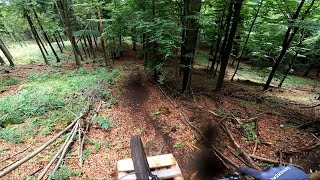
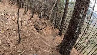
Photos of Straconka Elduro Mountain Bike
Videos of Straconka Elduro Mountain Bike
5:55 |
85 |
Nov 16, 2023
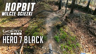
trail: Hopbit Access
7:59 |
635 |
Jul 31, 2019 , Bielsko-Biała
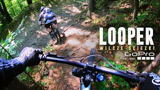
trail: Looper Access 2
16:39 |
730 |
Jul 31, 2019 , Bielsko-Biała
trail: Rajdowa
0:35 |
307 |
Apr 11, 2019 , Bielsko-Biała
Recent Trail Reports
| status | trail | date | condition | info | user |
|---|---|---|---|---|---|
| Krąg Łysej | May 10, 2026 @ 12:10pm (Europe/Warsaw) May 10, 2026 | Ideal | Jarek09 GANDI | ||
| Krąg Łysej Access | May 10, 2026 @ 12:10pm (Europe/Warsaw) May 10, 2026 | Ideal | Jarek09 GANDI | ||
| Do skrótu gaikowego | May 1, 2026 @ 12:03pm (Europe/Bratislava) May 1, 2026 | Ideal | Jarek09 GANDI | ||
| na Bułę | Apr 26, 2026 @ 10:29am (Europe/Bratislava) Apr 26, 2026 | Ideal | Jarek09 GANDI | ||
| na Wiewióra | Apr 26, 2026 @ 10:29am (Europe/Bratislava) Apr 26, 2026 | Ideal | Jarek09 GANDI | ||
| Ambonka Pani Jolci | Dec 28, 2025 @ 11:52am (Europe/Warsaw) Dec 28, 2025 | Ideal | Jarek09 GANDI | ||
| Skrót przez bagno | Dec 28, 2025 @ 11:52am (Europe/Warsaw) Dec 28, 2025 | Ideal | Jarek09 GANDI | ||
| z Rycha na Lopera | Oct 4, 2025 @ 11:17am (Europe/Bratislava) Oct 4, 2025 | Variable | slavio | ||
| Jałowcowa | Sep 21, 2025 @ 9:44am (Europe/Bratislava) Sep 21, 2025 | Ideal | Jarek09 GANDI | ||
| Yedźmin Access | Aug 10, 2025 @ 12:06pm Aug 10, 2025 | Unknown | Jarek09 GANDI |
Activity Feed
| username | action | type | title | date |
|---|---|---|---|---|
| uPWpk7 | wishlist | route | activity #96565150 | Jun 8, 2026 @ 2:50pm Jun 8, 2026 |
| gandal | add | trail | activity #96531374 and 1 more | Jun 8, 2026 @ 4:53am Jun 8, 2026 |
| gandal | update | trail | activity #95031405 | May 19, 2026 @ 4:28am May 19, 2026 |
| Jarek09 | add | report | activity #94137105 and 1 more | May 5, 2026 @ 9:48pm May 5, 2026 |
| MateuszPoFWFk | wishlist | region | activity #94012442 | May 4, 2026 @ 2:34am May 4, 2026 |
Recent Comments
| username | type | title | comment | date |
|---|---|---|---|---|
| report | Ta fajna ścieżka to lajtowa końcówka Looper1;) | Oct 24, 2017 @ 6:33am Oct 24, 2017 |
Nearby Areas
| name | distance | ||||
|---|---|---|---|---|---|
| Magurka Wilkowicka | 2 km | ||||
| Międzybrodzie Bialskie | 4 | 2.9 km | |||
| Enduro Trails Bielsko-Biała | 6 | 3 | 3.3 km | ||
| PKL Bike Park Góra Żar | 1 | 1 | 4.8 km | ||
| Enduro Trails Szczyrk | 1 | 2 | 9.2 km |
Bike & Skill Parks
| name | type | city | rating |
|---|---|---|---|
| Dworek | skill park | Bielsko-Biała |
Activity Type Stats
| activitytype | trails | distance | descent | descent distance | total vertical | rating | global rank | state rank | photos | reports | routes | ridelogs |
|---|---|---|---|---|---|---|---|---|---|---|---|---|
| Mountain Bike | 50 | 41 miles | 4,318 ft | 15 miles | 1,821 ft | #664 | #9 | 127 | 575 | 1 | 5,152 | |
| E-Bike | 45 | 18 miles | 2,096 ft | 4 miles | 1,470 ft | #750 | #22 | 560 | 1,690 | |||
| Hike | 48 | 42 miles | 3,855 ft | 15 miles | 1,821 ft | #1,033 | #22 | 555 | 669 | |||
| Trail Running | 50 | 42 miles | 3,855 ft | 15 miles | 1,821 ft | #574 | #11 | 555 | 122 | |||
| Nordic Ski | 17 | 4,948 ft | 16 ft | 784 ft | 476 ft | #170 | #8 | 2 | 66 |
Frequently Asked Questions About Straconka Elduro
▼
What are the highest rated mountain biking trails in Straconka Elduro?
The highest rated mountain biking trails in Straconka Elduro are:
- Z Przegibka (4.1/5)
- Nad Rzeką (0/5)
- Czerwony (0/5)
- Amfiteatr-Leśna (0/5)
- Traversy (0/5)
▼
What is the best time of the year to ride in Straconka Elduro?
Based on ride log data, the most popular months to ride in Straconka Elduro are:
- June (15 activities)
- July (12 activities)
- May (12 activities)
▼
Where can I park to ride in Straconka Elduro?
There are 1 parking locations listed in Straconka Elduro. The most popular parking spots are:
▼
What is the longest trail in Straconka Elduro?
The longest trail in Straconka Elduro is Amfiteatr-Leśna at 1.8 km. View all trails sorted by distance.
Activities
Trails
- By micolai
 TRAILFORKS Poland & contributors
 - Admins: Ecoriders, WŚ, GANDI
- #19663 - 19,989 views
- straconka elduro activity log | embed map of Straconka Elduro mountain bike trails | straconka elduro mountain biking points of interest
Downloading of trail gps tracks in kml & gpx formats is enabled for Straconka Elduro.
You must login to download files.