close
-
Layers w
- Weather Layers
- Pro
- Pro
- Pro
- Pro
- Pro
- Pro
- More Layers
- Pro
- Pro
- Pro
- Pro
-
Upgrade to

3D
Trail Conditions
- Unknown
- Snow Groomed
- Snow Packed
- Snow Covered
- Snow Cover Partial
- Freeze/thaw Cycle
- Icy
- Prevalent Mud
- Wet
- Variable
- Ideal
- Dry
- Very Dry
Trail Flow (Ridden Direction)
Trailforks scans users ridelogs to determine the most popular direction each trail is ridden. A good flowing trail network will have most trails flowing in a single direction according to their intension.
The colour categories are based on what percentage of riders are riding a trail in its intended direction.
The colour categories are based on what percentage of riders are riding a trail in its intended direction.
- > 96%
- > 90%
- > 80%
- > 70%
- > 50%
- < 50%
- bi-directional trail
- no data
Trail Last Ridden
Trailforks scans ridelogs to determine the last time a trail was ridden.
- < 2 days
- < 1 week
- < 2 weeks
- < 1 month
- < 6 months
- > 6 months
Trail Ridden Direction
The intended direction a trail should be ridden.
- Downhill Only
- Downhill Primary
- Both Directions
- Uphill Primary
- Uphill Only
- One Direction
Contribute Details
Colors indicate trail is missing specified detail.
- Description
- Photos
- Description & Photos
- Videos
Trail Popularity ?
Trailforks scans ridelogs to determine which trails are ridden the most in the last 9 months.
Trails are compared with nearby trails in the same city region with a possible 25 colour shades.
Think of this as a heatmap, more rides = more kinetic energy = warmer colors.
- most popular
- popular
- less popular
- not popular
ATV/ORV/OHV Filter
Max Vehicle Width
inches
US Cell Coverage
Legend

Radar Time
Activity Recordings
Trailforks uses anonymized public activity data.
?
Activity Recordings
Trailforks uses anonymized public activity data.
?
Personal Heatmap
▶
Activity Types
all
/
none
▶
Options
2
Date range
month
–
Winter Trails
Warning
A routing network for winter maps does not exist. Selecting trails using the winter trails layer has been disabled.
Missing Trails
Most Popular
Least Popular
Trails are colored based on popularity. The more popular a trail is, the more red. Less popular trails trend towards green.
Jump Magnitude Heatmap
Heatmap of where riders jump on trails. Zoom in to see individual jumps, click circles to view jump details.
BC Backroad Status
![map legend]()
Service Road Atlas is a free to use, community-driven service for viewing and creating reports on the numerous back-country service roads around B.C. and Alberta.

Slope Aspect
Direction the slope faces
Trails Deemphasized
Trails are shown in grey.
Only show trails with no bike usage.
Suggested Layers
Based on selected activity type
Save the current map location and zoom level as your default home location whenever this page is loaded.
Save
No description for Stratton has been added yet!
Login or register to submit one.
Links
Activities Click to view
- Mountain Bike
23 trails
- E-Bike
8 trails
- Adaptive Bike
0 trails
- Hike
10 trails
- Trail Running
10 trails
- Snowshoe
1 trails
- Downhill Ski
108 trails
- Backcountry Ski
0 trails
- Nordic Ski
4 trails
Region Details
- 2
- 8
- 10
- 3
Region Status
Caution as of Jun 10, 2026Stats
- Avg Trail Rating
- Trails (view details)
- 138
- Trails Mountain Bike
- 23
- Trails E-Bike
- 8
- Trails Hike
- 10
- Trails Trail Running
- 10
- Trails Snowshoe
- 1
- Trails Downhill Ski
- 108
- Trails Nordic Ski
- 4
- Total Distance
- 63 miles
- Total Descent Distance
- 53 miles
- Total Descent
- 42,212 ft
- Total Vertical
- 1,949 ft
- Highest Trailhead
- 3,940 ft
- Reports
- 401
- Photos
- 18
- Ridden Counter
- 19,955
Sub Regions
-
Stratton Mountain Resort Bike Park
- 7
- 10
- 3
-
Stratton Town Forest
- 3
- 2
Popular Stratton Mountain Biking Trails
• 80 ★ 5.0 • 1,598 ft • 0 ft • 377 •
Popular blue difficulty singletrack. This mountain bike primary trail can be used downhill only and has a moderate overall physical rating. Trail visibility is always easy to follow. On average it takes 1 minutes to complete this trail.
• 95 ★ 4.2 • 1 mile • 0 ft • 374 •
Highly rated popular blue difficulty singletrack. This mountain bike primary trail can be used downhill only. On average it takes 5 minutes to complete this trail.
• 65 ★ 4.0 • 1,004 ft • 0 ft • 352 •
Moderately popular green difficulty singletrack. This mountain bike primary trail can be used downhill only and has a easy overall physical rating. Trail visibility is always easy to follow. On average it takes minutes to complete this trail.
• 60 ★ 4.4 • 1,965 ft • 0 ft • 330 •
Moderately popular blue difficulty singletrack. This mountain bike primary trail can be used downhill only and has a moderate overall physical rating. Trail visibility is always easy to follow. On average it takes 2 minutes to complete this trail.
• 75 ★ 4.8 • 2,680 ft • 0 ft • 320 •
Mostly flowy with some light tech thrown in, this is a fan favorite.
• 90 ★ 5.0 • 955 ft • 0 ft • 289 •
Entry level mini terrain park with berms, mini-rock garden, and rollers serviced by a carpet lift.
• 45 ★ 3.5 • 3,077 ft • 0 ft • 279 •
Moderately popular green difficulty singletrack. This mountain bike primary trail can be used downhill only and has a easy overall physical rating. Trail visibility is always easy to follow. On average it takes 1 minutes to complete this trail.
Photos of Stratton Mountain Bike
Videos of Stratton Mountain Bike

trail: Kick Start
0:43 |
65 |
May 27, 2025 , Stratton
trail: Paper Route
3:00 |
338 |
Sep 16, 2023 , Stratton

trail: Fox Trot
0:47 |
309 |
Jun 5, 2023 , Stratton

trail: Lunch Pad
0:39 |
283 |
Jul 27, 2022 , Stratton
527 |
Mar 24, 2022
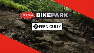
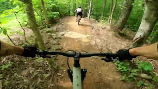
trail: Fern Gully
0:37 |
326 |
Mar 17, 2022 , Stratton
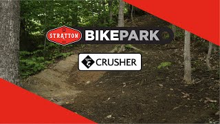
trail: Crusher
2:16 |
473 |
Mar 17, 2022 , Stratton

trail: Loam Shark
0:13 |
364 |
Mar 17, 2022 , Stratton
Recent Trail Reports
| status | trail | date | condition | info | user |
|---|---|---|---|---|---|
| Loam Shark | Jun 6, 2026 @ 8:26am (America/New_York) Jun 6, 2026 | Ideal | mappermook TRAILFORKS | ||
| Ground Control - Uphill Only | Jun 6, 2026 @ 8:26am (America/New_York) Jun 6, 2026 | Dry | mappermook TRAILFORKS | ||
| Grinder | Jun 6, 2026 @ 8:26am (America/New_York) Jun 6, 2026 | Dry | mappermook TRAILFORKS | ||
| Garden Gnomes | Jun 6, 2026 @ 8:26am (America/New_York) Jun 6, 2026 | Ideal | mappermook TRAILFORKS | ||
| Gravitas | Jun 6, 2026 @ 8:26am (America/New_York) Jun 6, 2026 | Ideal | mappermook TRAILFORKS | ||
| Fern Gully | Jun 6, 2026 @ 8:26am (America/New_York) Jun 6, 2026 | Variable | mappermook TRAILFORKS | ||
| Fox Trot | Jun 6, 2026 @ 8:26am (America/New_York) Jun 6, 2026 | Ideal | mappermook TRAILFORKS | ||
| Trail Forest One | Jun 6, 2026 @ 8:26am (America/New_York) Jun 6, 2026 | Ideal | mappermook TRAILFORKS | ||
| Kick Start | Jun 6, 2026 @ 8:26am (America/New_York) Jun 6, 2026 | Ideal | mappermook TRAILFORKS | ||
| Short Straw | Jun 6, 2026 @ 8:26am (America/New_York) Jun 6, 2026 | Variable | mappermook TRAILFORKS |
Activity Feed
| username | action | type | title | date |
|---|---|---|---|---|
| pigpenms | add | report | activity #96688880 | Jun 10, 2026 @ 12:10pm Jun 10, 2026 |
| mappermook | add | report | activity #96424211 and 9 more | Jun 6, 2026 @ 7:14pm Jun 6, 2026 |
| Stevebw33up | wishlist | region | activity #95744179 | May 28, 2026 @ 5:18pm May 28, 2026 |
| andrewskimtb | ridden | trail | activity #95344362 and 4 more | May 23, 2026 @ 12:21pm May 23, 2026 |
| Mchickering | wishlist | region | activity #95288814 | May 22, 2026 @ 9:16pm May 22, 2026 |
Recent Comments
| username | type | title | comment | date |
|---|---|---|---|---|
| trail | Meh not worth the pedal out in my opinion. | Sep 30, 2023 @ 2:34pm Sep 30, 2023 | ||
| trail | A little too much fire road early on. Could... | Sep 30, 2023 @ 2:33pm Sep 30, 2023 | ||
| trail | Fun beginner flow trail. | Sep 30, 2023 @ 2:31pm Sep 30, 2023 | ||
| trail | I like this trail. Most of it is a fun tech... | Sep 30, 2023 @ 2:31pm Sep 30, 2023 | ||
| trail | Fun enough but flow could be improved. | Sep 30, 2023 @ 2:29pm Sep 30, 2023 |
Local Badges
-

Epic Mountain Bike Climb 2k168 awarded -

Climbing 10k Badge20 awarded -

Mountain Biking 100k Badge0 awarded -

Big Ride 30k315 awarded -

Epic Ride 50k88 awarded -

Epic Ride Descent 2k132 awarded
Bike & Skill Parks
| name | type | city | rating |
|---|---|---|---|
| Stratton Mountain Resort Bike Park | bike park | Stratton | |
| Stratton Mountain Resort | bike park | Stratton |
Activity Type Stats
| activitytype | trails | distance | descent | descent distance | total vertical | rating | global rank | state rank | photos | reports | routes | ridelogs |
|---|---|---|---|---|---|---|---|---|---|---|---|---|
| Mountain Bike | 23 | 13 miles | 5,056 ft | 10 miles | 732 ft | #3,540 | #1,205 | 15 | 314 | 3,209 | ||
| E-Bike | 8 | 5 miles | 1,988 ft | 3 miles | 715 ft | #6,985 | #2,100 | 248 | 69 | |||
| Hike | 10 | 12 miles | 1,043 ft | 5 miles | 1,834 ft | #7,744 | #2,735 | 3 | 201 | 409 | ||
| Trail Running | 10 | 12 miles | 1,043 ft | 5 miles | 1,834 ft | #8,334 | #2,776 | 201 | 149 | |||
| Snowshoe | 1 | 3,533 ft | 112 ft | 1,699 ft | 102 ft | #454 | #148 | 87 | 9 | |||
| Downhill Ski | 108 | 40 miles | 36,440 ft | 39 miles | 1,890 ft | #141 | #60 | 87 | 3,128 | |||
| Nordic Ski | 4 | #451 | #133 | 87 | 179 |
Frequently Asked Questions About Stratton
▼
What are the best places to ride in Stratton?
Stratton has 4 areas to explore for mountain biking. The top rated areas are:
▼
What are the highest rated mountain biking trails in Stratton?
The highest rated mountain biking trails in Stratton are:
- Gravitas (4.3/5)
- Paper Route (4.3/5)
- Kick Start (4.2/5)
- Fern Gully (4.2/5)
- Fox Trot (4.2/5)
▼
What is the best time of the year to ride in Stratton?
Based on ride log data, the most popular months to ride in Stratton are:
- July (18 activities)
- August (13 activities)
- June (6 activities)
▼
Where can I park to ride in Stratton?
There are 3 parking locations listed in Stratton. The most popular parking spots are: View all parking and trailhead locations on the map to plan your visit.
Activities
Trails
- By WillieJacobsz
 Trailforks SBP SWW & contributors
 - Admins: VMBA, Velomont, Jwduston, WCoTA, NATSVMBA, SoVTA
- #31420 - 7,090 views
- stratton activity log | embed map of Stratton mountain bike trails | stratton mountain biking points of interest
Downloading of trail gps tracks in kml & gpx formats is enabled for Stratton.
You must login to download files.