close
-
Layers w
- Weather Layers
- Pro
- Pro
- Pro
- Pro
- Pro
- Pro
- More Layers
- Pro
- Pro
- Pro
- Pro
-
Upgrade to

3D
Trail Conditions
- Unknown
- Snow Groomed
- Snow Packed
- Snow Covered
- Snow Cover Partial
- Freeze/thaw Cycle
- Icy
- Prevalent Mud
- Wet
- Variable
- Ideal
- Dry
- Very Dry
Trail Flow (Ridden Direction)
Trailforks scans users ridelogs to determine the most popular direction each trail is ridden. A good flowing trail network will have most trails flowing in a single direction according to their intension.
The colour categories are based on what percentage of riders are riding a trail in its intended direction.
The colour categories are based on what percentage of riders are riding a trail in its intended direction.
- > 96%
- > 90%
- > 80%
- > 70%
- > 50%
- < 50%
- bi-directional trail
- no data
Trail Last Ridden
Trailforks scans ridelogs to determine the last time a trail was ridden.
- < 2 days
- < 1 week
- < 2 weeks
- < 1 month
- < 6 months
- > 6 months
Trail Ridden Direction
The intended direction a trail should be ridden.
- Downhill Only
- Downhill Primary
- Both Directions
- Uphill Primary
- Uphill Only
- One Direction
Contribute Details
Colors indicate trail is missing specified detail.
- Description
- Photos
- Description & Photos
- Videos
Trail Popularity ?
Trailforks scans ridelogs to determine which trails are ridden the most in the last 9 months.
Trails are compared with nearby trails in the same city region with a possible 25 colour shades.
Think of this as a heatmap, more rides = more kinetic energy = warmer colors.
- most popular
- popular
- less popular
- not popular
ATV/ORV/OHV Filter
Max Vehicle Width
inches
US Cell Coverage
Legend

Radar Time
Activity Recordings
Trailforks uses anonymized public activity data.
?
Activity Recordings
Trailforks uses anonymized public activity data.
?
Personal Heatmap
▶
Activity Types
all
/
none
▶
Options
2
Date range
month
–
Winter Trails
Warning
A routing network for winter maps does not exist. Selecting trails using the winter trails layer has been disabled.
Missing Trails
Most Popular
Least Popular
Trails are colored based on popularity. The more popular a trail is, the more red. Less popular trails trend towards green.
Jump Magnitude Heatmap
Heatmap of where riders jump on trails. Zoom in to see individual jumps, click circles to view jump details.
BC Backroad Status
![map legend]()
Service Road Atlas is a free to use, community-driven service for viewing and creating reports on the numerous back-country service roads around B.C. and Alberta.

Slope Aspect
Direction the slope faces
Trails Deemphasized
Trails are shown in grey.
Only show trails with no bike usage.
Suggested Layers
Based on selected activity type
Save the current map location and zoom level as your default home location whenever this page is loaded.
Save
No description for Stroudsburg has been added yet!
Login or register to submit one.
Activities Click to view
- Mountain Bike
48 trails
- Adaptive Bike
9 trails
- Hike
54 trails
- Trail Running
54 trails
Region Details
- 3
- 4
- 15
- 24
- 2
Region Status
Open as of May 3, 2026Stats
- Avg Trail Rating
- Trails (view details)
- 54
- Trails Mountain Bike
- 48
- Trails E-Bike
- 2
- Trails Gravel Bike
- 8
- Trails Adaptive Bike
- 9
- Trails Hike
- 54
- Trails Trail Running
- 54
- Total Distance
- 49 miles
- Total Descent
- 6,338 ft
- Total Vertical
- 1,131 ft
- Highest Trailhead
- 1,453 ft
- Reports
- 611
- Photos
- 36
- Ridden Counter
- 10,874
Articles
Video & Race Report: Maxxis Eastern States Cup Stan's Enduro in Glen Park, PA
Jun 6, 2023 from pinkbike.com
Glen Park is small but mighty, there's a whole lot of excitement packed into this 500' hill.
Sub Regions
-
Delaware Water Gap
-
Glen Park
- 1
- 11
- 9
-
West End Regional Park
- 2
- 6
- 8
- 2
Popular Stroudsburg Mountain Biking Trails
• 85 ★ 2.9 • 2 miles • 483 ft • 719 •
Used for the 2017 Eastern States Cup Enduro series climbing Stage.
• 80 ★ 4.4 • 5,082 ft • 3 ft • 714 •
connector trail that runs parallel to Godfrey Ridge Road
• 95 ★ 3.5 • 1,211 ft • 0 ft • 636 •
starts to the left of the power line trail (looking downhill). rips through and connects with stage 2. has a nice size rock drop to hit along the way.
• 60 ★ 3.9 • 3,894 ft • 3 ft • 474 •
Moderately popular blue difficulty singletrack. This mountain bike primary trail. It features berm and gap jump. On average it takes 5 minutes to complete this trail.
Stroudsburg Mountain Bike Routes
6 miles • 477 ft • 0 • Loop •
Nice 6 mile loop that keeps you mainly on the main roads with a short section of walking trails. The route...
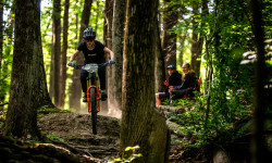
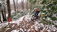
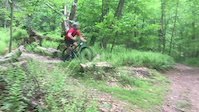
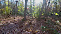
Photos of Stroudsburg Mountain Bike
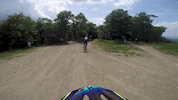
Videos of Stroudsburg Mountain Bike
trail: Glen Park
8:21 |
191 |
Dec 19, 2021
trail: Glen Park Stage 3
0:19 |
227 |
Nov 28, 2021
trail: Glen Park Stage 3
0:05 |
286 |
Jul 2, 2021

trail: Glen Park Stage 5
3:45 |
280 |
Apr 24, 2018

trail: Glen Park Stage 2
3:03 |
559 |
Dec 7, 2017
trail: Glen Park Stage 3
0:09 |
606 |
Nov 1, 2017
trail: Fun Stuff
13:17 |
345 |
Jun 4, 2015
youtuber
![WERP speed: Finding the flow in flat turns -...]()

11:44 |
168 |
May 20, 2024
Recent Trail Reports
| status | trail | date | condition | info | user |
|---|---|---|---|---|---|
| Glen Park | May 3, 2026 @ 1:16pm (America/New_York) May 3, 2026 | Ideal | chriscrisp | ||
| Unnamed Trail | May 3, 2026 @ 1:16pm (America/New_York) May 3, 2026 | Ideal | chriscrisp | ||
| Unnamed Trail | May 3, 2026 @ 1:16pm (America/New_York) May 3, 2026 | Ideal | chriscrisp | ||
| Glenn Middle Run | May 3, 2026 @ 1:16pm (America/New_York) May 3, 2026 | Ideal | chriscrisp | ||
| GP Trail | May 3, 2026 @ 1:16pm (America/New_York) May 3, 2026 | Ideal | chriscrisp | ||
| Glen Park Stage 5 | May 3, 2026 @ 1:16pm (America/New_York) May 3, 2026 | Ideal | chriscrisp | ||
| Climb Stage 2017 ESC Enduro | May 3, 2026 @ 1:16pm (America/New_York) May 3, 2026 | Ideal | chriscrisp | ||
| Power Line Ripper | Apr 11, 2026 @ 11:06am (America/New_York) Apr 11, 2026 | Ideal | chrisn5 | ||
| Glen Park Stage 3 | Apr 11, 2026 @ 11:06am (America/New_York) Apr 11, 2026 | Ideal | chrisn5 | ||
| GP Trail | Apr 11, 2026 @ 11:06am (America/New_York) Apr 11, 2026 | Ideal | chrisn5 |
Activity Feed
| username | action | type | title | date |
|---|---|---|---|---|
| BrettFcaGsN | wishlist | trail | activity #97270915 | Jun 18, 2026 @ 12:47pm 1 day |
| Chefmarc | ridden | trail | activity #97249226 | Jun 18, 2026 @ 7:00am 2 days |
| asnowmobiler | wishlist | region | activity #96738895 | Jun 11, 2026 @ 8:16am Jun 11, 2026 |
| pberiont | wishlist | region | activity #96222409 | Jun 4, 2026 @ 6:26am Jun 4, 2026 |
| harlanjesse | wishlist | route | activity #95534425 | May 25, 2026 @ 5:19pm May 25, 2026 |
Recent Comments
| username | type | title | comment | date |
|---|---|---|---|---|
| trail | As of 11/13/2024, Glen Park has been approved... | May 21, 2025 @ 6:34am May 21, 2025 | ||
| trail | Fun fast nice jumps and burms | Jul 25, 2024 @ 1:01pm Jul 25, 2024 | ||
| report | Nice conditions | Oct 22, 2023 @ 6:18am Oct 22, 2023 | ||
| trail | Watch out for bum huts | Aug 9, 2023 @ 12:32pm Aug 9, 2023 | ||
| report | Do not follow climb trail, it is not accurate... | Apr 15, 2023 @ 8:19am Apr 15, 2023 |
Local Badges
-

10 Blue Trails319 awarded -

Epic Ride Climb 2k12 awarded -

Climbing 10k Badge47 awarded -

Climbing 100k Badge1 awarded -

Epic Ride Descent 2k30 awarded -

Descent 10k Badge52 awarded
Activity Type Stats
| activitytype | trails | distance | descent | descent distance | total vertical | rating | global rank | state rank | photos | reports | routes | ridelogs |
|---|---|---|---|---|---|---|---|---|---|---|---|---|
| Mountain Bike | 48 | 46 miles | 5,531 ft | 18 miles | 761 ft | #2,497 | #895 | 32 | 611 | 2 | 8,768 | |
| E-Bike | 2 | 22 miles | 722 ft | 7 miles | 253 ft | 4 | 593 | 1 | 772 | |||
| Gravel Bike | 8 | 27 miles | 1,401 ft | 9 miles | 538 ft | #853 | #463 | 41 | 39 | |||
| Adaptive Bike | 9 | 26 miles | 1,063 ft | 8 miles | 538 ft | #413 | #1,757 | 52 | ||||
| Hike | 54 | 49 miles | 6,339 ft | 21 miles | 1,132 ft | #4,692 | #1,654 | 611 | 2 | 572 | ||
| Trail Running | 54 | 49 miles | 6,339 ft | 21 miles | 1,132 ft | #4,372 | #1,339 | 611 | 1 | 80 |
Frequently Asked Questions About Stroudsburg
▼
What are the best places to ride in Stroudsburg?
Stroudsburg has 3 areas to explore for mountain biking. The top rated areas are:
▼
What are the highest rated mountain biking trails in Stroudsburg?
The highest rated mountain biking trails in Stroudsburg are:
- Glen Park Stage 5 (4.3/5)
- Broadhead Creek Doubletrack (4.1/5)
- Glenn Middle Run (4.1/5)
- Glen Park Stage 2 (4.1/5)
- Glen Park Stage 4 (4/5)
▼
What is the best time of the year to ride in Stroudsburg?
Based on ride log data, the most popular months to ride in Stroudsburg are:
- May (148 activities)
- June (136 activities)
- July (128 activities)
▼
Where can I park to ride in Stroudsburg?
There are 13 parking locations listed in Stroudsburg. The most popular parking spots are: View all parking and trailhead locations on the map to plan your visit.
Activities
Trails
- By Wqvk & contributors
- Admins: PBC
- #15758 - 6,702 views
- stroudsburg activity log | embed map of Stroudsburg mountain bike trails | stroudsburg mountain biking points of interest
Downloading of trail gps tracks in kml & gpx formats is enabled for Stroudsburg.
You must login to download files.