close
-
Layers w
- Weather Layers
- Pro
- Pro
- Pro
- Pro
- Pro
- Pro
- More Layers
- Pro
- Pro
- Pro
- Pro
-
Upgrade to

3D
Trail Conditions
- Unknown
- Snow Groomed
- Snow Packed
- Snow Covered
- Snow Cover Partial
- Freeze/thaw Cycle
- Icy
- Prevalent Mud
- Wet
- Variable
- Ideal
- Dry
- Very Dry
Trail Flow (Ridden Direction)
Trailforks scans users ridelogs to determine the most popular direction each trail is ridden. A good flowing trail network will have most trails flowing in a single direction according to their intension.
The colour categories are based on what percentage of riders are riding a trail in its intended direction.
The colour categories are based on what percentage of riders are riding a trail in its intended direction.
- > 96%
- > 90%
- > 80%
- > 70%
- > 50%
- < 50%
- bi-directional trail
- no data
Trail Last Ridden
Trailforks scans ridelogs to determine the last time a trail was ridden.
- < 2 days
- < 1 week
- < 2 weeks
- < 1 month
- < 6 months
- > 6 months
Trail Ridden Direction
The intended direction a trail should be ridden.
- Downhill Only
- Downhill Primary
- Both Directions
- Uphill Primary
- Uphill Only
- One Direction
Contribute Details
Colors indicate trail is missing specified detail.
- Description
- Photos
- Description & Photos
- Videos
Trail Popularity ?
Trailforks scans ridelogs to determine which trails are ridden the most in the last 9 months.
Trails are compared with nearby trails in the same city region with a possible 25 colour shades.
Think of this as a heatmap, more rides = more kinetic energy = warmer colors.
- most popular
- popular
- less popular
- not popular
ATV/ORV/OHV Filter
Max Vehicle Width
inches
US Cell Coverage
Legend

Radar Time
Activity Recordings
Trailforks uses anonymized public activity data.
?
Activity Recordings
Trailforks uses anonymized public activity data.
?
Personal Heatmap
▶
Activity Types
all
/
none
▶
Options
2
Date range
month
–
Winter Trails
Warning
A routing network for winter maps does not exist. Selecting trails using the winter trails layer has been disabled.
Missing Trails
Most Popular
Least Popular
Trails are colored based on popularity. The more popular a trail is, the more red. Less popular trails trend towards green.
Jump Magnitude Heatmap
Heatmap of where riders jump on trails. Zoom in to see individual jumps, click circles to view jump details.
BC Backroad Status
![map legend]()
Service Road Atlas is a free to use, community-driven service for viewing and creating reports on the numerous back-country service roads around B.C. and Alberta.

Slope Aspect
Direction the slope faces
Trails Deemphasized
Trails are shown in grey.
Only show trails with no bike usage.
Suggested Layers
Based on selected activity type
Save the current map location and zoom level as your default home location whenever this page is loaded.
Save
No description for Malacky has been added yet!
Login or register to submit one.
Activities Click to view
- Mountain Bike
39 trails
- E-Bike
19 trails
- Adaptive Bike
0 trails
- Winter Fat Bike
0 trails
- Hike
29 trails
- Trail Running
29 trails
Region Details
- 13
- 6
- 16
- 4
Region Status
Open as of 2 daysStats
- Avg Trail Rating
- Trails (view details)
- 41
- Trails Mountain Bike
- 39
- Trails E-Bike
- 19
- Trails Horse
- 2
- Trails Hike
- 29
- Trails Trail Running
- 29
- Trails Dirtbike/Moto
- 2
- Trails Observed Trials
- 1
- Trails ATV/ORV/OHV
- 2
- Total Distance
- 44 miles
- Total Descent
- 9,869 ft
- Total Vertical
- 1,214 ft
- Highest Trailhead
- 1,907 ft
- Reports
- 1,006
- Photos
- 303
- Ridden Counter
- 2,425
Sub Regions
-
Lozorno
- 10
- 2
-
Pajštún
- 3
- 2
- 1
-
Plavecký Mikuláš
- 2
- 2
Popular Malacky Mountain Biking Trails
• 100 ★ 4.9 • 1 mile • 0 ft • 164 •
Flow trail pre stredne pokrocilych jazdcov, vsetky prekazky s obchadzkami. Trail sa priebezne udrziava/vyladuje
• 65 ★ 4.7 • 2,953 ft • 0 ft • 157 •
Highly rated moderately popular blue difficulty singletrack. This mountain bike primary trail can be used downhill primary and has a moderate overall physical rating with a 0 ft green climb. It features berm, jump, gap jump, rock garden and skinny. On average it takes 4 minutes to complete this trail.
• 85 ★ 4.5 • 1 mile • 5 ft • 136 •
Highly rated popular blue difficulty singletrack. This mountain bike primary trail can be used downhill primary and has a moderate overall physical rating with a 5 ft green climb. On average it takes 10 minutes to complete this trail.
• 75 ★ 5.0 • 1 mile • 0 ft • 122 •
technicky náročnejší trail s množstvom zaujímavých prírodných prekážok , zmysel bol vyskladat dobrý tréningový enduro trail , vela rockgarden-ových pasáží , prírodné dropy , korienky , vela zábavy
• 90 ★ 4.8 • 1 mile • 0 ft • 105 •
Ľahký singletrail, bez vacsich prekážok. Vhodný aj pre začiatočníkov
• 100 ★ 4.6 • 1 mile • 9 ft • 94 •
Tralik s modrou obtiaznostou, zatial nedostavany ale plne prejazdny. Priebezne pridavame prvky/upravujeme. Pozri video pre lepsiu orientaciu
• 20 ★ 4.4 • 2 miles • 10 ft • 91 •
Highly rated less popular blue difficulty singletrack. This mountain bike primary trail can be used downhill only. It features berm, drop, jump and gap jump. On average it takes 14 minutes to complete this trail.
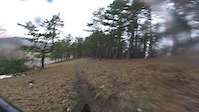
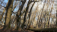
Photos of Malacky Mountain Bike
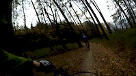
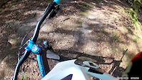
Videos of Malacky Mountain Bike
trail: Jelenia Hora
0:20 |
134 |
May 9, 2021
trail: Maják
0:06 |
|
Jan 14, 2020
trail: Maják
6:12 |
643 |
Nov 11, 2018
trail: Flow trail Ohek
4:09 |
466 |
Oct 15, 2018
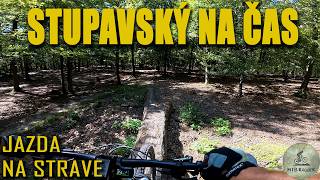
trail: Stupavský trail
3:38 |
28 |
Jan 6, 2026 , Malacky
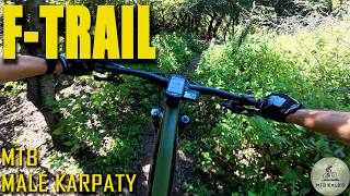
trail: F Trail
2:24 |
21 |
Jan 6, 2026 , Malacky
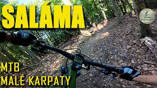
trail: Saláma (Malokarpatská)
4:24 |
32 |
Jan 6, 2026 , Malacky
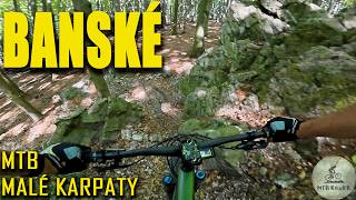
trail: Banské
8:27 |
25 |
Jan 6, 2026 , Malacky
Current Trail Warnings
| status | trail | date | condition | user | info |
|---|---|---|---|---|---|
| Maják | Jun 16, 2026 @ 12:12pm (Europe/Bratislava) 2 days | Variable | Matejhc45lc | Bol som maják pozrieť a vrch je stále... |
Recent Trail Reports
| status | trail | date | condition | info | user |
|---|---|---|---|---|---|
| Amonova luka - Kubasova | Jun 15, 2026 @ 3:11pm (Europe/Bratislava) 2 days | Ideal | jsakalos | ||
| Kukučák 2 | Jun 16, 2026 @ 4:04pm (Europe/Bratislava) 1 day | Dry | Karol100 | ||
| Saláma (Malokarpatská) | Jun 16, 2026 @ 12:15pm (Europe/Bratislava) 2 days | Ideal | Matejhc45lc | ||
| Flow trail Ohek | Jun 16, 2026 @ 12:14pm (Europe/Bratislava) 2 days | Unknown | Matejhc45lc | ||
| Salamandra | Jun 16, 2026 @ 12:13pm (Europe/Bratislava) 2 days | Unknown | Matejhc45lc | ||
| Baťkuf járek | May 24, 2026 @ 11:47am (Europe/Bratislava) May 24, 2026 | Dry | Guli | ||
| F Trail | May 20, 2026 @ 11:49am (Europe/Bratislava) May 20, 2026 | Ideal | Matejhc45lc | ||
| Korenec trail | May 14, 2026 @ 6:43pm (Europe/Bratislava) May 14, 2026 | Ideal | Matejhc45lc | ||
| Stupavský trail | May 14, 2026 @ 6:43pm (Europe/Bratislava) May 14, 2026 | Ideal | Matejhc45lc | ||
| Skala trail | May 2, 2026 @ 2:56pm (Europe/Bratislava) May 2, 2026 | Dry | JanW0mMs8 |
Activity Feed
| username | action | type | title | date |
|---|---|---|---|---|
| jsakalos | add | report | activity #97186109 | Jun 17, 2026 @ 8:33am 7 hours |
| Matejhc45lc | add | report | activity #97096746 and 1 more | Jun 16, 2026 @ 3:14am 2 days |
| Matejhc45lc | add | report | activity #97096653 and 1 more | Jun 16, 2026 @ 3:12am 2 days |
| DegRJcQV | wishlist | trail | activity #96431156 | Jun 6, 2026 @ 10:16pm Jun 6, 2026 |
| paternoster | ridden | trail | activity #95476099 and 1 more | May 25, 2026 @ 3:56am May 25, 2026 |
Recent Comments
| username | type | title | comment | date |
|---|---|---|---|---|
| trail | Bolo by dobre spraviť nejakú organizovanú... | Nov 27, 2024 @ 11:28am Nov 27, 2024 | ||
| trail | Trail bez listí | Nov 11, 2024 @ 1:35am Nov 11, 2024 | ||
| trail | Trail bohužel momentálně pod listím | Nov 11, 2024 @ 1:33am Nov 11, 2024 | ||
| trail | Za mne nejlepsi zábava v okolí | Aug 6, 2024 @ 5:03am Aug 6, 2024 | ||
| trail | Trail je super | Aug 6, 2024 @ 5:02am Aug 6, 2024 |
Local Badges
-

Descent 100k Badge0 awarded -

Big Ride 30k415 awarded -
Big Ride 30k1,097 awarded -

Epic Ride 50k198 awarded -

Descent 10k Badge15 awarded -

Epic Ride Descent 2k25 awarded
Bike & Skill Parks
| name | type | city | rating |
|---|---|---|---|
| Pumptrack Stupava | skill park | Malacky | |
| Bike and scooter zona Lozorno | skill park | Malacky |
Activity Type Stats
| activitytype | trails | distance | descent | descent distance | total vertical | rating | global rank | state rank | photos | reports | routes | ridelogs |
|---|---|---|---|---|---|---|---|---|---|---|---|---|
| Mountain Bike | 39 | 38 miles | 8,983 ft | 17 miles | 1,148 ft | #1,303 | #14 | 297 | 1,004 | 1 | 11,900 | |
| E-Bike | 19 | 19 miles | 2,192 ft | 6 miles | 1,096 ft | #1,213 | #12 | 6 | 702 | 1,916 | ||
| Horse | 2 | 3 miles | 13 ft | 489 ft | 1,053 ft | 89 | ||||||
| Hike | 29 | 37 miles | 6,804 ft | 14 miles | 1,214 ft | #1,653 | #17 | 848 | 1,021 | |||
| Trail Running | 29 | 37 miles | 6,804 ft | 14 miles | 1,214 ft | #1,258 | #15 | 849 | 255 | |||
| Dirtbike/Moto | 2 | 3 miles | 13 ft | 489 ft | 1,053 ft | 89 | 1 | |||||
| Observed Trials | 1 | 1,621 ft | 13 ft | 489 ft | 13 ft | 3 | ||||||
| ATV/ORV/OHV | 2 | 3 miles | 13 ft | 489 ft | 1,053 ft | 89 |
Frequently Asked Questions About Malacky
▼
What are the best places to ride in Malacky?
Malacky has 3 areas to explore for mountain biking. The top rated areas are:
▼
What are the highest rated mountain biking trails in Malacky?
The highest rated mountain biking trails in Malacky are:
- Flow trail Ohek (4.6/5)
- Maják (4.6/5)
- Banské (4.5/5)
- Saláma (Malokarpatská) (4.5/5)
- Strmok (4.5/5)
▼
What is the best time of the year to ride in Malacky?
Based on ride log data, the most popular months to ride in Malacky are:
- July (43 activities)
- September (41 activities)
- June (36 activities)
▼
Where can I park to ride in Malacky?
Check the Malacky trail map for trailhead and parking information. Community members regularly update access and parking details for trails in the area.
Activities
Trails
Points of Interest
- By vladol
 & contributors
 - Admins: apply
- #14062 - 6,348 views
- malacky activity log | embed map of Malacky mountain bike trails |
Downloading of trail gps tracks in kml & gpx formats is enabled for Malacky.
You must login to download files.