close
-
Layers w
- Weather Layers
- Pro
- Pro
- Pro
- Pro
- Pro
- Pro
- More Layers
- Pro
- Pro
- Pro
- Pro
-
Upgrade to

3D
Trail Conditions
- Unknown
- Snow Groomed
- Snow Packed
- Snow Covered
- Snow Cover Partial
- Freeze/thaw Cycle
- Icy
- Prevalent Mud
- Wet
- Variable
- Ideal
- Dry
- Very Dry
Trail Flow (Ridden Direction)
Trailforks scans users ridelogs to determine the most popular direction each trail is ridden. A good flowing trail network will have most trails flowing in a single direction according to their intension.
The colour categories are based on what percentage of riders are riding a trail in its intended direction.
The colour categories are based on what percentage of riders are riding a trail in its intended direction.
- > 96%
- > 90%
- > 80%
- > 70%
- > 50%
- < 50%
- bi-directional trail
- no data
Trail Last Ridden
Trailforks scans ridelogs to determine the last time a trail was ridden.
- < 2 days
- < 1 week
- < 2 weeks
- < 1 month
- < 6 months
- > 6 months
Trail Ridden Direction
The intended direction a trail should be ridden.
- Downhill Only
- Downhill Primary
- Both Directions
- Uphill Primary
- Uphill Only
- One Direction
Contribute Details
Colors indicate trail is missing specified detail.
- Description
- Photos
- Description & Photos
- Videos
Trail Popularity ?
Trailforks scans ridelogs to determine which trails are ridden the most in the last 9 months.
Trails are compared with nearby trails in the same city region with a possible 25 colour shades.
Think of this as a heatmap, more rides = more kinetic energy = warmer colors.
- most popular
- popular
- less popular
- not popular
ATV/ORV/OHV Filter
Max Vehicle Width
inches
US Cell Coverage
Legend

Radar Time
Activity Recordings
Trailforks uses anonymized public activity data.
?
Activity Recordings
Trailforks uses anonymized public activity data.
?
Personal Heatmap
▶
Activity Types
all
/
none
▶
Options
2
Date range
month
–
Winter Trails
Warning
A routing network for winter maps does not exist. Selecting trails using the winter trails layer has been disabled.
Missing Trails
Most Popular
Least Popular
Trails are colored based on popularity. The more popular a trail is, the more red. Less popular trails trend towards green.
Jump Magnitude Heatmap
Heatmap of where riders jump on trails. Zoom in to see individual jumps, click circles to view jump details.
BC Backroad Status
![map legend]()
Service Road Atlas is a free to use, community-driven service for viewing and creating reports on the numerous back-country service roads around B.C. and Alberta.

Slope Aspect
Direction the slope faces
Trails Deemphasized
Trails are shown in grey.
Only show trails with no bike usage.
Suggested Layers
Based on selected activity type
Save the current map location and zoom level as your default home location whenever this page is loaded.
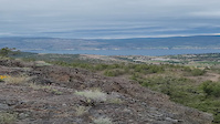
SaveThe Summerland trail system has grown in recent years. It consists of two main areas, Conkle and Cartwright. Conkle benefits from spectacular views and fun descents, and is accessed from the Trans Canada Trail. The Cartwright area originally started with the Test of Humanity course, but has expanded to the west, right up to the main summit of Cartwright.
Activities Click to view
- Mountain Bike
40 trails
- E-Bike
26 trails
- Gravel Bike
0 trails
- Adaptive Bike
0 trails
- Winter Fat Bike
0 trails
- Horse
5 trails
- Hike
44 trails
- Trail Running
44 trails
- Snowshoe
3 trails
Region Details
- 2
- 9
- 25
- 4
Region Status
Open as of May 18, 2026Stats
- Avg Trail Rating
- Trails (view details)
- 45
- Trails Mountain Bike
- 40
- Trails E-Bike
- 26
- Trails Horse
- 5
- Trails Hike
- 44
- Trails Trail Running
- 44
- Trails Dirtbike/Moto
- 1
- Trails ATV/ORV/OHV
- 1
- Trails Snowshoe
- 3
- Total Distance
- 44 miles
- Total Descent
- 9,919 ft
- Total Vertical
- 1,692 ft
- Highest Trailhead
- 3,438 ft
- Reports
- 1,147
- Photos
- 257
- Ridden Counter
- 16,809
Sub Regions
-
Cartwright Mountain
- 5
- 18
- 4
-
Conkle Mountain
- 3
- 7
-
Morel
- 1
Popular Summerland Mountain Biking Trails
• 90 ★ 4.6 • 4,251 ft • 109 ft • 996 •
New and better section added to the Test of Humanity race trail.
• 35 ★ 4.6 • 6 miles • 937 ft • 944 •
The is the main feature of an annual race and fundraiser of the same name. The supports Canadian Humanitarian aid and the Okanagan Food Bank. This 10k loop features thousands of volunteer hours that carefully shaped it into one epic...
• 100 ★ 4.4 • 3 miles • 1,129 ft • 548 •
As the primary climb up the east side of Conkle, this trail gets a fair bit of traffic and maintenance. Grades are forgiving and the views get more spectacular as the elevation increases. Includes two "false summits" before ascending to...
• 85 ★ 4.4 • 3 miles • 198 ft • 526 •
Classic old-school singletrack that can be ridden up or down between the TCT and the summit ridge. It's the main route on the west side of the mountain, with spectacular views in all directions -- above Trout Creek in the lower...
• 100 ★ 4.5 • 2 miles • 106 ft • 359 •
The classic east-side descent from the summit to the TCT, originally cobbled together from game trails around 2006, then fixed up and extended over the years. It's not technically difficult, but gets more challenging when it's dry and...
• 70 ★ 0.0 • 2 miles • 47 ft • 326 •
Temporary duplicate to allow badging of the PACA Virtual Fiver #2 Family
• 65 ★ 4.0 • 1,565 ft • 0 ft • 262 •
A fun little traverse/DH section that takes you from the north end of K2 or to the pond and Roxy Roller. There are a couple of steep, tricky, loose corners with some technical difficulty, and a couple of small jumps that can be...
Summerland Mountain Bike Routes
★ 5.0 • 24 miles • 3,819 ft • 9 •
@ stages of Cowboy Country! See you atthe rodeo grounds!
47 miles • 4,694 ft • 0 •
draft of a 75km day out of the rodeo grounds...a different climatic zone than the other loop
42 miles • 3,848 ft • 0 •
67km lollipop design out and back on kvr with a clasic all gravel road loop..
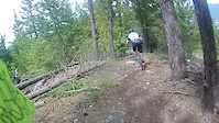
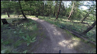
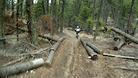
Photos of Summerland Mountain Bike
Videos of Summerland Mountain Bike
trail: Hairway to Steven
0:10 |
|
Jun 3, 2022
trail: Conkle DH
2:41 |
636 |
May 20, 2016
trail: Test of Humanity Trail
0:17 |
1021 |
May 14, 2016

trail: IN
4:51 |
664 |
Jun 13, 2012
trail: IN
0:35 |
303 |
Apr 12, 2012

trail: IN
3:16 |
184 |
Aug 24, 2011
trail: IN
0:25 |
192 |
Jun 2, 2011
Recent Trail Reports
| status | trail | date | condition | info | user |
|---|---|---|---|---|---|
| Janky Skidder | May 18, 2026 @ 11:53am (America/Creston) May 18, 2026 | Ideal | outdoorilo | ||
| Roxy Roller | May 18, 2026 @ 11:53am (America/Creston) May 18, 2026 | Ideal | outdoorilo | ||
| Rollercoaster | May 18, 2026 @ 11:53am (America/Creston) May 18, 2026 | Ideal | outdoorilo | ||
| Test of Humanity Trail | May 4, 2026 @ 1:47pm (America/Vancouver) May 4, 2026 | Dry | lj1-5 | ||
| Elmer Fudd | May 3, 2026 @ 6:38pm (America/Creston) May 3, 2026 | Ideal | snowyslopes | ||
| Full Frontal | Apr 30, 2026 @ 2:32pm (America/Vancouver) Apr 30, 2026 | Unknown | merlin99 | ||
| Bypass | Apr 14, 2026 @ 10:44am (America/Vancouver) Apr 14, 2026 | Ideal | Joehiker | ||
| Frontside | Apr 14, 2026 @ 10:44am (America/Vancouver) Apr 14, 2026 | Ideal | Joehiker | ||
| Dragon's Back | Mar 23, 2026 @ 1:40pm (America/Creston) Mar 23, 2026 | Ideal | thehumped | ||
| You are Welcome | Mar 23, 2026 @ 1:40pm (America/Creston) Mar 23, 2026 | Ideal | thehumped |
Activity Feed
| username | action | type | title | date |
|---|---|---|---|---|
| patSM4U1C | wishlist | region | activity #96931379 | Jun 13, 2026 @ 6:20pm Jun 13, 2026 |
| dgthomson | ridden | trail | activity #96632342 and 2 more | Jun 9, 2026 @ 3:15pm Jun 9, 2026 |
| dgthomson | ridden | trail | activity #96632321 and 1 more | Jun 9, 2026 @ 3:14pm Jun 9, 2026 |
| Magcarpediem | wishlist | trail | activity #96553968 | Jun 8, 2026 @ 11:35am Jun 8, 2026 |
| powderdaylife | wishlist | trail | activity #96552460 | Jun 8, 2026 @ 11:14am Jun 8, 2026 |
Recent Comments
| username | type | title | comment | date |
|---|---|---|---|---|
| trail | A new favourite. | May 18, 2026 @ 2:35pm May 18, 2026 | ||
| trail | Love this trail, first timers should be aware... | Apr 24, 2026 @ 6:18pm Apr 24, 2026 | ||
| trail | Trail is not to be found. Should be taken off... | Apr 21, 2026 @ 7:15am Apr 21, 2026 | ||
| trail | Definitely rideable but some muddy areas. Easy... | Feb 15, 2026 @ 5:35pm Feb 15, 2026 | ||
| trail | Riding well, a few icy patches after the first... | Jan 10, 2026 @ 8:51am Jan 10, 2026 |
Local Badges
-

Epic Ride Climb 2k68 awarded -

Climbing 10k Badge65 awarded -

Climbing 100k Badge8 awarded -

Epic Ride Descent 2k72 awarded -

Descent 10k Badge65 awarded -

Descent 100k Badge8 awarded
Activity Type Stats
| activitytype | trails | distance | descent | descent distance | total vertical | rating | global rank | state rank | photos | reports | routes | ridelogs |
|---|---|---|---|---|---|---|---|---|---|---|---|---|
| Mountain Bike | 40 | 39 miles | 8,852 ft | 18 miles | 1,647 ft | #1,654 | #64 | 251 | 1,145 | 6 | 16,272 | |
| E-Bike | 26 | 25 miles | 4,760 ft | 11 miles | 1,594 ft | #3,465 | #83 | 1,001 | 1,312 | |||
| Horse | 5 | 4 miles | 413 ft | 4,094 ft | 988 ft | #435 | #22 | 168 | 65 | |||
| Hike | 44 | 43 miles | 9,656 ft | 19 miles | 1,693 ft | #3,913 | #105 | 6 | 1,114 | 4,043 | ||
| Trail Running | 44 | 43 miles | 9,656 ft | 19 miles | 1,693 ft | #3,952 | #97 | 1,113 | 678 | |||
| Dirtbike/Moto | 1 | 1 mile | 499 ft | 161 | 3 | 185 | ||||||
| ATV/ORV/OHV | 1 | 1 mile | 499 ft | 161 | 8 | |||||||
| Snowshoe | 3 | 4 miles | 377 ft | 3,451 ft | 1,266 ft | #1,090 | #58 | 18 | 17 |
Frequently Asked Questions About Summerland
▼
What are the best places to ride in Summerland?
Summerland has 4 areas to explore for mountain biking. The top rated areas are:
▼
What are the highest rated mountain biking trails in Summerland?
The highest rated mountain biking trails in Summerland are:
- Test of Humanity Trail (4.5/5)
- Hairway to Steven (4.4/5)
- Yahoo & Repeat (4.4/5)
- T2 (4.4/5)
- Roxy Roller (4.4/5)
▼
What is the best time of the year to ride in Summerland?
Based on ride log data, the most popular months to ride in Summerland are:
- July (270 activities)
- May (218 activities)
- June (203 activities)
▼
Where can I park to ride in Summerland?
There are 2 parking locations listed in Summerland. The most popular parking spots are:
Activities
Trails
- By 1partatatime
 PACA & contributors
 - Admins: canadianenduro, PACA, SMBA, headspacej, PACA, 1partatatime, PACApenticton
- #5955 - 22,002 views
- summerland activity log | embed map of Summerland mountain bike trails | summerland mountain biking points of interest
Downloading of trail gps tracks in kml & gpx formats is enabled for Summerland.
You must login to download files.