close
-
Layers w
- Weather Layers
- Pro
- Pro
- Pro
- Pro
- Pro
- Pro
- More Layers
- Pro
- Pro
- Pro
- Pro
-
Upgrade to

3D
Trail Conditions
- Unknown
- Snow Groomed
- Snow Packed
- Snow Covered
- Snow Cover Partial
- Freeze/thaw Cycle
- Icy
- Prevalent Mud
- Wet
- Variable
- Ideal
- Dry
- Very Dry
Trail Flow (Ridden Direction)
Trailforks scans users ridelogs to determine the most popular direction each trail is ridden. A good flowing trail network will have most trails flowing in a single direction according to their intension.
The colour categories are based on what percentage of riders are riding a trail in its intended direction.
The colour categories are based on what percentage of riders are riding a trail in its intended direction.
- > 96%
- > 90%
- > 80%
- > 70%
- > 50%
- < 50%
- bi-directional trail
- no data
Trail Last Ridden
Trailforks scans ridelogs to determine the last time a trail was ridden.
- < 2 days
- < 1 week
- < 2 weeks
- < 1 month
- < 6 months
- > 6 months
Trail Ridden Direction
The intended direction a trail should be ridden.
- Downhill Only
- Downhill Primary
- Both Directions
- Uphill Primary
- Uphill Only
- One Direction
Contribute Details
Colors indicate trail is missing specified detail.
- Description
- Photos
- Description & Photos
- Videos
Trail Popularity ?
Trailforks scans ridelogs to determine which trails are ridden the most in the last 9 months.
Trails are compared with nearby trails in the same city region with a possible 25 colour shades.
Think of this as a heatmap, more rides = more kinetic energy = warmer colors.
- most popular
- popular
- less popular
- not popular
ATV/ORV/OHV Filter
Max Vehicle Width
inches
US Cell Coverage
Legend

Radar Time
Activity Recordings
Trailforks uses anonymized public activity data.
?
Activity Recordings
Trailforks uses anonymized public activity data.
?
Personal Heatmap
▶
Activity Types
all
/
none
▶
Options
2
Date range
month
–
Winter Trails
Warning
A routing network for winter maps does not exist. Selecting trails using the winter trails layer has been disabled.
Missing Trails
Most Popular
Least Popular
Trails are colored based on popularity. The more popular a trail is, the more red. Less popular trails trend towards green.
Jump Magnitude Heatmap
Heatmap of where riders jump on trails. Zoom in to see individual jumps, click circles to view jump details.
BC Backroad Status
![map legend]()
Service Road Atlas is a free to use, community-driven service for viewing and creating reports on the numerous back-country service roads around B.C. and Alberta.

Slope Aspect
Direction the slope faces
Trails Deemphasized
Trails are shown in grey.
Only show trails with no bike usage.
Suggested Layers
Based on selected activity type
Save the current map location and zoom level as your default home location whenever this page is loaded.
SaveSun Mountain is packed full of singletrack and doubletrack trails of all difficulty, find your line and ride.
PLEASE NOTE: Hunting season is typically mid to late October each year . Please be aware of active hunting in this area and be respectful and careful.
PLEASE NOTE: Hunting season is typically mid to late October each year . Please be aware of active hunting in this area and be respectful and careful.
source: ...
Primary Trail Type: Cross-Country
eBikes Allowed:
No
AKA: Chickadee
Land Status: National Forest
 google parking directions
 Activities Click to view
- Mountain Bike
43 trails
- E-Bike
4 trails
- Horse
13 trails
- Hike
55 trails
- Trail Running
55 trails
- Nordic Ski
20 trails
Region Details
- 9
- 15
- 13
- 2
- 1
Region Status
Open as of Jun 5, 2026Stats
- Avg Trail Rating
- Trails (view details)
- 56
- Trails Mountain Bike
- 43
- Trails E-Bike
- 4
- Trails Horse
- 13
- Trails Hike
- 55
- Trails Trail Running
- 55
- Trails Dirtbike/Moto
- 2
- Trails Snowshoe
- 2
- Trails Nordic Ski
- 20
- Total Distance
- 81 miles
- Total Descent
- 13,943 ft
- Total Vertical
- 2,740 ft
- Highest Trailhead
- 4,938 ft
- Reports
- 819
- Photos
- 247
- Ridden Counter
- 17,201
Popular Sun Mountain Mountain Biking Trails
• 100 ★ 3.7 • 2 miles • 683 ft • 1,167 •
Climbing Trail from Lower Climb It or Inner Passage to the top of , , and .
• 100 ★ 4.0 • 3,520 ft • 19 ft • 1,145 •
Highly rated popular blue difficulty singletrack. This mountain bike primary trail can be used both directions. On average it takes 8 minutes to complete this trail.
• 100 ★ 4.1 • 1 mile • 380 ft • 1,125 •
Climbing trail to get to upper Sun Mountain trails and ultimately trail
• 95 ★ 4.6 • 3 miles • 29 ft • 717 •
is the trail to ride in the Sun Mountain area. A must-ride trial that has well-built berms and plenty of rollable features that will make riders of all abilities smile. The trail has three distinct sections (upper, middle, and Lower)...
• 90 ★ 4.4 • 13 miles • 2,344 ft • 595 •
is designed to be ridden clockwise or south to north. Offers nice climbing grade with many view opportunities etc. Mix of open meadows, forested areas and rock outcroppings. Descending off the north end is fast and fun with many options...
• 95 ★ 4.2 • 1 mile • 701 ft • 595 •
Largely Rebuilt in 2023 by Evergreen, is a step up in difficulty from . It has table tops, rollable doubles, step-ups, step-downs, and shark fins. The largest jump is near the bottom at 25 feet to the sweet spot.
• 85 ★ 4.6 • 5 miles • 719 ft • 467 •
A nice flowing singletrack trail that follows the ridge to the east of . Trail starts at the intersection of and road and gently gains the first summit and then descends south on the ridge towards Twisp River road. Return can be the...
• 80 ★ 3.9 • 3 miles • 604 ft • 419 •
is a well built trail with fast flowy descents mixed with easy climbs. Fun for all types of riders and has a great viewpoint just before where intersects the trial. A must ride in the Sun Mountain area.
Sun Mountain Mountain Bike Routes
★ 4.0 • 20 miles • 3,602 ft • 4 •
Great Sun Mountain 20 mile sampler. Utilizes most of the new trails at Sun Mountain to make a great loop....
11 miles • 1,638 ft • 5 •
part 2 of the 30 miles of Sun Mountain.. this segment climbs back up the Upper Climb trail to access the...
17 miles • 3,476 ft • 5 • Loop •
part 1 of a 29 mile route that starts at .. part 1 is the segment.. the entire route can take 5 hrs..
17 miles • 2,311 ft • 15 • Loop •
Course for the Sport Category.
Photos of Sun Mountain Mountain Bike
Videos of Sun Mountain Mountain Bike
trail: Ain't Never Nuthin
0:07 |
|
Sep 19, 2023

trail: Black Bear
7:04 |
898 |
Oct 27, 2016
trail: Magpie Horse
3:05 |
120 |
May 28, 2015

trail: Pete's Dragon
342 |
Oct 9, 2023 , Winthrop

trail: Ain't Never Nuthin
615 |
Oct 9, 2023 , Winthrop
youtuber
![Coal Creek and Pete's Dragon]()
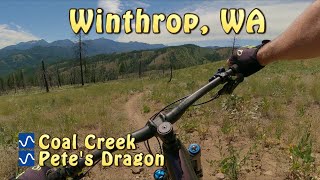
trail: Pete's Dragon
10:12 |
766 |
Aug 6, 2022 , Winthrop
youtuber
![Coal Creek and Pete's Dragon]()

trail: Coal Creek
10:12 |
676 |
Aug 6, 2022 , Winthrop
trail: Wild Turkey
4:07 |
2532 |
Jun 15, 2020 , Winthrop
Recent Trail Reports
| status | trail | date | condition | info | user |
|---|---|---|---|---|---|
| Chickadee connector | May 23, 2026 @ 11:41am (America/Vancouver) May 23, 2026 | Ideal | daoloth | ||
| Magpie multi-use | May 23, 2026 @ 11:41am (America/Vancouver) May 23, 2026 | Ideal | daoloth | ||
| Thompson Ridge | May 23, 2026 @ 11:41am (America/Vancouver) May 23, 2026 | Ideal | daoloth | ||
| Climb It Change Upper | May 25, 2026 @ 9:07am (America/Vancouver) May 25, 2026 | Ideal | daoloth | ||
| Yellowjacket | Oct 1, 2025 @ 6:41am (America/Los_Angeles) Oct 1, 2025 | Very Dry | slaughter327 | ||
| Lower Fox | May 14, 2025 @ 1:50pm May 14, 2025 | Ideal | marebearrr | ||
| Meadowlark Trail | Apr 19, 2024 @ 9:47am Apr 19, 2024 | Ideal | Nitsua016 |
Activity Feed
| username | action | type | title | date |
|---|---|---|---|---|
| shadubya | wishlist | trail | activity #97137016 and 1 more | Jun 16, 2026 @ 2:09pm 1 day |
| GWE35 | add | photo | activity #97020115 | Jun 14, 2026 @ 7:53pm Jun 14, 2026 |
| EchoFoxtrotBravo | ridden | trail | activity #96928437 and 3 more | Jun 13, 2026 @ 5:24pm Jun 13, 2026 |
| iqirDd | ridden | trail | activity #96761737 | Jun 11, 2026 @ 2:34pm Jun 11, 2026 |
| EchoFoxtrotBravo | ridden | trail | activity #96712676 and 1 more | Jun 10, 2026 @ 7:16pm Jun 10, 2026 |
Recent Comments
| username | type | title | comment | date |
|---|---|---|---|---|
| trail | Might have first tracks on this trail for the... | Apr 27, 2026 @ 9:11am Apr 27, 2026 | ||
| trail | 5 trees across trail. | Nov 9, 2025 @ 11:30am Nov 9, 2025 | ||
| trail | Turkey is in good shape other than downed... | Oct 18, 2025 @ 7:40pm Oct 18, 2025 | ||
| trail | A lot of downed trees on the climb, one or two... | Oct 6, 2025 @ 9:37am Oct 6, 2025 | ||
| trail | Fun trail, but definitely a case of "I found... | Oct 6, 2025 @ 9:24am Oct 6, 2025 |
Nearby Areas
| name | distance | ||||
|---|---|---|---|---|---|
| Liberty Bell School Campus | 1 | 4.7 km | |||
| Rendezvous Wildlife Area | 2 | 2 | 6.4 km | ||
| Pearrygin Lake State Park | 1 | 1 | 6.9 km | ||
| Lookout Mountain | 1 | 1 | 8.8 km | ||
| Pipestone Canyon | 5 | 3 | 1 | 9.6 km |
Local Badges
-

Completionist0 awarded
Local Products
Local Trail Supporters
- Evergreen Mountain Bike Alliance -Methow Chapter
Activity Type Stats
| activitytype | trails | distance | descent | descent distance | total vertical | rating | global rank | state rank | photos | reports | routes | ridelogs |
|---|---|---|---|---|---|---|---|---|---|---|---|---|
| Mountain Bike | 43 | 68 miles | 11,289 ft | 28 miles | 2,740 ft | #1,610 | #550 | 245 | 814 | 12 | 6,382 | |
| E-Bike | 4 | 4 miles | 102 ft | 5,272 ft | 354 ft | #7,838 | #2,362 | 428 | 267 | |||
| Horse | 13 | 11 miles | 1,496 ft | 5 miles | 1,306 ft | #1,846 | #973 | 139 | 2 | |||
| Hike | 55 | 77 miles | 13,205 ft | 33 miles | 2,740 ft | #2,840 | #971 | 1 | 809 | 1 | 298 | |
| Trail Running | 55 | 77 miles | 13,205 ft | 33 miles | 2,740 ft | #2,196 | #520 | 809 | 1 | 253 | ||
| Dirtbike/Moto | 2 | 3 miles | 92 ft | 4,859 ft | 62 ft | 82 | 2 | |||||
| Snowshoe | 2 | 1 mile | 13 ft | 413 ft | 243 ft | 3 | 11 | |||||
| Nordic Ski | 20 | 24 miles | 2,936 ft | 11 miles | 1,234 ft | #423 | #114 | 8 | 642 |
Frequently Asked Questions About Sun Mountain
▼
What are the highest rated mountain biking trails in Sun Mountain?
The highest rated mountain biking trails in Sun Mountain are:
- Pete's Dragon (4.5/5)
- Ain't Never Nuthin (4.4/5)
- Coal Creek (4.3/5)
- Thompson Ridge (4.3/5)
- Wild Turkey (4.3/5)
▼
What is the best time of the year to ride in Sun Mountain?
Based on ride log data, the most popular months to ride in Sun Mountain are:
- June (174 activities)
- May (174 activities)
- July (137 activities)
▼
Where can I park to ride in Sun Mountain?
There are 10 parking locations listed in Sun Mountain. The most popular parking spots are: View all parking and trailhead locations on the map to plan your visit.
▼
What is the longest trail in Sun Mountain?
The longest trail in Sun Mountain is Thompson Ridge at 13.0 miles. View all trails sorted by distance.
Activities
Trails
- By averyspacehall & contributors
- Admins: EMBA-METHOW
- #4556 - 26,689 views
- sun mountain activity log | embed map of Sun Mountain mountain bike trails | sun mountain mountain biking points of interest polygons
Downloading of trail gps tracks in kml & gpx formats is enabled for Sun Mountain.
You must login to download files.