close
-
Layers w
- Weather Layers
- Pro
- Pro
- Pro
- Pro
- Pro
- Pro
- More Layers
- Pro
- Pro
- Pro
- Pro
-
Upgrade to

3D
Trail Conditions
- Unknown
- Snow Groomed
- Snow Packed
- Snow Covered
- Snow Cover Partial
- Freeze/thaw Cycle
- Icy
- Prevalent Mud
- Wet
- Variable
- Ideal
- Dry
- Very Dry
Trail Flow (Ridden Direction)
Trailforks scans users ridelogs to determine the most popular direction each trail is ridden. A good flowing trail network will have most trails flowing in a single direction according to their intension.
The colour categories are based on what percentage of riders are riding a trail in its intended direction.
The colour categories are based on what percentage of riders are riding a trail in its intended direction.
- > 96%
- > 90%
- > 80%
- > 70%
- > 50%
- < 50%
- bi-directional trail
- no data
Trail Last Ridden
Trailforks scans ridelogs to determine the last time a trail was ridden.
- < 2 days
- < 1 week
- < 2 weeks
- < 1 month
- < 6 months
- > 6 months
Trail Ridden Direction
The intended direction a trail should be ridden.
- Downhill Only
- Downhill Primary
- Both Directions
- Uphill Primary
- Uphill Only
- One Direction
Contribute Details
Colors indicate trail is missing specified detail.
- Description
- Photos
- Description & Photos
- Videos
Trail Popularity ?
Trailforks scans ridelogs to determine which trails are ridden the most in the last 9 months.
Trails are compared with nearby trails in the same city region with a possible 25 colour shades.
Think of this as a heatmap, more rides = more kinetic energy = warmer colors.
- most popular
- popular
- less popular
- not popular
ATV/ORV/OHV Filter
Max Vehicle Width
inches
US Cell Coverage
Legend

Radar Time
Activity Recordings
Trailforks uses anonymized public activity data.
?
Activity Recordings
Trailforks uses anonymized public activity data.
?
Personal Heatmap
▶
Activity Types
all
/
none
▶
Options
2
Date range
month
–
Winter Trails
Warning
A routing network for winter maps does not exist. Selecting trails using the winter trails layer has been disabled.
Missing Trails
Most Popular
Least Popular
Trails are colored based on popularity. The more popular a trail is, the more red. Less popular trails trend towards green.
Jump Magnitude Heatmap
Heatmap of where riders jump on trails. Zoom in to see individual jumps, click circles to view jump details.
BC Backroad Status
![map legend]()
Service Road Atlas is a free to use, community-driven service for viewing and creating reports on the numerous back-country service roads around B.C. and Alberta.

Slope Aspect
Direction the slope faces
Trails Deemphasized
Trails are shown in grey.
Only show trails with no bike usage.
Suggested Layers
Based on selected activity type
Save the current map location and zoom level as your default home location whenever this page is loaded.
Save
No description for Superior has been added yet!
Login or register to submit one.
Activities Click to view
- Mountain Bike
48 trails
- E-Bike
0 trails
- Gravel Bike
0 trails
- Adaptive Bike
0 trails
- Horse
19 trails
- Hike
251 trails
- Trail Running
251 trails
- Dirtbike/Moto
4 trails
- ATV/ORV/OHV
4 trails
Region Details
- 30
- 3
- 5
- 4
- 3
Region Status
Caution as of Jun 12, 2026Local Trail Association
Stats
- Avg Trail Rating
- Trails (view details)
- 47
- Trails Mountain Bike
- 48
- Trails Horse
- 19
- Trails Hike
- 252
- Trails Trail Running
- 251
- Trails Dirtbike/Moto
- 4
- Trails ATV/ORV/OHV
- 4
- Total Distance
- 146 miles
- Total Descent
- 15,390 ft
- Total Vertical
- 3,855 ft
- Highest Trailhead
- 5,442 ft
- Reports
- 142
- Photos
- 335
- Ridden Counter
- 4,731
Articles
12 Endangered Trails to Hike Before They're Gone
Jan 14, 2022 from backpacker.com
From climate change to energy development, various threats promise to wipe out what’s best about America’s 12 most endangered trails.
Sub Regions
-
Boyce Thompson Arboretum
Popular Superior Mountain Biking Trails
• 100 ★ 4.5 • 12 miles • 2,276 ft • 380 •
This passage begins at a gate just north of the Tonto National Forest boundary about 0.4 miles due west of Ajax Peak. From here the trail climbs briefly and then drops down into a drainage about 1 mile in. After crossing this drainage...
• 30 ★ 3.4 • 6 miles • 2,571 ft • 201 •
From the Reavis Canyon Trailhead to the Rogers Trough Trailhead and the Superstition Wilderness boundary
• 95 ★ 4.4 • 3 miles • 418 ft • 180 •
Renovated trail through . Trail follows & crosses Arnett Creek multiple times. Creek flow is seasonal. This is the segment of the L.O.S.T. and will connect to Superior. AZT connector trail
• 100 ★ 4.0 • 25 miles • 4,371 ft • 102 •
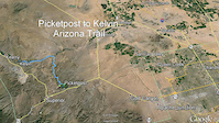
This passage begins at the Kelvin Bridge as it crosses the Gila River. Just beyond the north end of the bridge the route turns west onto Centurion Road and follows this past a few homes to a trailhead. From the trailhead, pass by the...
• 100 ★ 2.0 • 715 ft • 26 ft • 100 •
Easiest way to access the ATA rain collector is from the north by the gate. The 2-track south of the rain collector is incredibly loose & steep.
• 80 ★ 2.0 • 2,969 ft • 94 ft • 86 •
Shortcut between AZT-Picketpost Segment and FR4.
• 85 ★ 4.5 • 1 mile • 140 ft • 67 •
This is an extension of the Trail and links into the Trail. AZT connector trail
• 85 ★ 4.0 • 3,346 ft • 96 ft • 58 •
Nice alternative to accessing Arnett Canyon. Be warned, there is one short steep section where steps have been carved into the rock face, may require some hike-a-bike. AZT connector trail
Superior Mountain Bike Routes
★ 4.5 • 28 miles • 4,534 ft • 1 •
Actual climbing is 4,400 feet. Not the 6,200 calculated by TrailForks. Start from the Picketpost Trailhead...
★ 4.4 • 12 miles • 914 ft • 6 • Loop •
Counter Clockwise loop from the Picketpost trailhead using the segment of the Legends of Superior Trail...
11 miles • 740 ft • 1 • Point to Point •
17 miles • 3,619 ft • 2 • Point to Point •
51 miles • 6,814 ft • 22 •
A 46 mile loop covering the magical picketpost to kelvin section of the AZT looping back up to the...
Photos of Superior Mountain Bike
Videos of Superior Mountain Bike
trail: AZT - Alamo Canyon
6:12 |
267 |
Nov 30, 2018
trail: AZT - Alamo Canyon
5:07 |
201 |
Nov 30, 2018
trail: AZT - Alamo Canyon
5:26 |
98 |
Nov 30, 2018

trail: AZT - Alamo Canyon
4:38 |
156 |
Nov 29, 2018
trail: AZT - Alamo Canyon
9:56 |
357 |
Jan 6, 2016
trail: AZT - Alamo Canyon
5:25 |
416 |
Nov 20, 2014

trail: AZT - Alamo Canyon
14:49 |
456 |
Nov 3, 2014

trail: AZT - Alamo Canyon
6:04 |
223 |
Nov 3, 2014
Recent Trail Reports
| status | trail | date | condition | info | user |
|---|---|---|---|---|---|
| Telegraph Canyon | Apr 26, 2026 @ 8:33pm (America/Phoenix) Apr 26, 2026 | Unknown | dsrttaco | ||
| AZT/C - Arnett Canyon Spur | Feb 28, 2026 @ 8:00am (America/Phoenix) Feb 28, 2026 | Variable | Baergrizz | ||
| AZT - Whitford Canyon | Dec 31, 2025 @ 10:59am (America/Phoenix) Dec 31, 2025 | Unknown | gbuck | ||
| AZT/C - Arnett Loop Trail | Dec 27, 2025 @ 9:48am (America/Phoenix) Dec 27, 2025 | Dry | swampbear1 | ||
| Box Canyon rd. | Mar 8, 2025 @ 7:18pm Mar 8, 2025 | Freeze/thaw Cycle | CjgkvC | ||
| Rain Collector Access | Jan 4, 2025 @ 8:59am Jan 4, 2025 | Dry | dlr1967 | ||
| AZT - Alamo Canyon | Jan 4, 2025 @ 8:59am Jan 4, 2025 | Dry | dlr1967 | ||
| AZT - East Saddlebridge Trail | Jan 4, 2025 @ 8:59am Jan 4, 2025 | Dry | dlr1967 | ||
| AZT/C - L.O.S.T. Arnett Canyon | Nov 19, 2024 @ 11:12am Nov 19, 2024 | Dry | swampbear1 | ||
| AZT - Gila Canyons | Jan 27, 2024 @ 6:48am Jan 27, 2024 | Dry | Kcfarley |
Activity Feed
| username | action | type | title | date |
|---|---|---|---|---|
| redbeard66677 | wishlist | trail | activity #94186285 | May 6, 2026 @ 5:06pm May 6, 2026 |
| dsrttaco | add | report | activity #93497233 | Apr 26, 2026 @ 8:35pm Apr 26, 2026 |
| gswim18 | add | report | activity #92341764 | Apr 10, 2026 @ 1:56pm Apr 10, 2026 |
| fiorez33 | wishlist | route | activity #92287161 | Apr 9, 2026 @ 4:30pm Apr 9, 2026 |
| LiMiLu | wishlist | trail | activity #90334980 | Mar 10, 2026 @ 10:42am Mar 10, 2026 |
Recent Comments
| username | type | title | comment | date |
|---|---|---|---|---|
| trail | Pretty trail. Dare I say lush in. Completely... | Jan 22, 2026 @ 7:40pm Jan 22, 2026 | ||
| trail | My favourite section of Arnett, stunning... | Nov 9, 2024 @ 12:27pm Nov 9, 2024 | ||
| trail | It's a rideable but very rocky at times, works... | Nov 9, 2024 @ 12:24pm Nov 9, 2024 | ||
| trail | This is a tough climb. Wore the diaper, not a... | Jun 5, 2024 @ 9:28pm Jun 5, 2024 | ||
| trail | This was the most scenic ride I have done thus... | Apr 15, 2024 @ 7:28am Apr 15, 2024 |
Local Badges
-

Epic Ride Climb 2k72 awarded -

Climbing 10k Badge11 awarded -

Climbing 100k Badge0 awarded -

Epic Ride Descent 2k97 awarded -

Descent 10k Badge12 awarded -

Descent 100k Badge0 awarded
Activity Type Stats
| activitytype | trails | distance | descent | descent distance | total vertical | rating | global rank | state rank | photos | reports | routes | ridelogs |
|---|---|---|---|---|---|---|---|---|---|---|---|---|
| Mountain Bike | 48 | 142 miles | 12,923 ft | 48 miles | 3,855 ft | #2,485 | #890 | 320 | 143 | 16 | 1,784 | |
| Horse | 19 | 97 miles | 8,468 ft | 28 miles | 3,812 ft | #386 | #478 | 38 | 2 | 51 | ||
| Hike | 251 | 146 miles | 15,390 ft | 52 miles | 3,855 ft | #266 | #134 | 28 | 143 | 4 | 704 | |
| Trail Running | 251 | 146 miles | 15,390 ft | 52 miles | 3,855 ft | #919 | #346 | 143 | 1 | 126 | ||
| Dirtbike/Moto | 4 | 16 miles | 764 ft | 3 miles | 2,920 ft | #1,028 | #395 | 24 | 15 | |||
| ATV/ORV/OHV | 4 | 16 miles | 764 ft | 3 miles | 2,920 ft | #646 | #257 | 25 | 29 |
Frequently Asked Questions About Superior
▼
What are the best places to ride in Superior?
Superior has 1 areas to explore for mountain biking. The top rated areas are:
▼
What are the highest rated mountain biking trails in Superior?
The highest rated mountain biking trails in Superior are:
- AZT - Alamo Canyon (4.4/5)
- AZT/C - L.O.S.T. Arnett Canyon (4.4/5)
- AZT/C - Arnett Canyon Spur (4.1/5)
- AZT - Gila Canyons (4/5)
- AZT/C - Arnett Loop Trail (4/5)
▼
What is the best time of the year to ride in Superior?
Based on ride log data, the most popular months to ride in Superior are:
- January (39 activities)
- February (37 activities)
- November (36 activities)
▼
Where can I park to ride in Superior?
There are 6 parking locations listed in Superior. The most popular parking spots are:
- Parking - Picketpost Trailhead
- Boyce Thompson Picnic Area Parking Area
- Boyce Thompson Arboretum Visitor Center Parking Area
- Kelvin Alt TH
- Parking - Reavis Canyon Trailhead
Activities
Trails
Points of Interest
- Quincho Gazebo Other
- Demonstration Garden Other
- Picket Post House Lodge
- Wallace Rose Garden Other
- Wing Memorial Herb Garden Other
- Palm Grove Other
- South African Deserts Exhibit Other
- Mediterranean Garden Other
- Cactus and Succulent Garden Other
- Pistacia Grove Other
- Montana Mountain (5,528 ft)
- Kings Crown Peak (5,249 ft)
- Fortuna Peak (5,177 ft)
- By schillingsworth
 TRAILFORKS HTA & contributors
 - Admins: apply
- #5448 - 7,590 views
- superior activity log | embed map of Superior mountain bike trails | superior mountain biking points of interest
Downloading of trail gps tracks in kml & gpx formats is enabled for Superior.
You must login to download files.