close
-
Layers w
- Weather Layers
- Pro
- Pro
- Pro
- Pro
- Pro
- Pro
- More Layers
- Pro
- Pro
- Pro
- Pro
-
Upgrade to

3D
Trail Conditions
- Unknown
- Snow Groomed
- Snow Packed
- Snow Covered
- Snow Cover Partial
- Freeze/thaw Cycle
- Icy
- Prevalent Mud
- Wet
- Variable
- Ideal
- Dry
- Very Dry
Trail Flow (Ridden Direction)
Trailforks scans users ridelogs to determine the most popular direction each trail is ridden. A good flowing trail network will have most trails flowing in a single direction according to their intension.
The colour categories are based on what percentage of riders are riding a trail in its intended direction.
The colour categories are based on what percentage of riders are riding a trail in its intended direction.
- > 96%
- > 90%
- > 80%
- > 70%
- > 50%
- < 50%
- bi-directional trail
- no data
Trail Last Ridden
Trailforks scans ridelogs to determine the last time a trail was ridden.
- < 2 days
- < 1 week
- < 2 weeks
- < 1 month
- < 6 months
- > 6 months
Trail Ridden Direction
The intended direction a trail should be ridden.
- Downhill Only
- Downhill Primary
- Both Directions
- Uphill Primary
- Uphill Only
- One Direction
Contribute Details
Colors indicate trail is missing specified detail.
- Description
- Photos
- Description & Photos
- Videos
Trail Popularity ?
Trailforks scans ridelogs to determine which trails are ridden the most in the last 9 months.
Trails are compared with nearby trails in the same city region with a possible 25 colour shades.
Think of this as a heatmap, more rides = more kinetic energy = warmer colors.
- most popular
- popular
- less popular
- not popular
ATV/ORV/OHV Filter
Max Vehicle Width
inches
US Cell Coverage
Legend

Radar Time
Activity Recordings
Trailforks uses anonymized public activity data.
?
Activity Recordings
Trailforks uses anonymized public activity data.
?
Personal Heatmap
▶
Activity Types
all
/
none
▶
Options
2
Date range
month
–
Winter Trails
Warning
A routing network for winter maps does not exist. Selecting trails using the winter trails layer has been disabled.
Missing Trails
Most Popular
Least Popular
Trails are colored based on popularity. The more popular a trail is, the more red. Less popular trails trend towards green.
Jump Magnitude Heatmap
Heatmap of where riders jump on trails. Zoom in to see individual jumps, click circles to view jump details.
BC Backroad Status
![map legend]()
Service Road Atlas is a free to use, community-driven service for viewing and creating reports on the numerous back-country service roads around B.C. and Alberta.

Slope Aspect
Direction the slope faces
Trails Deemphasized
Trails are shown in grey.
Only show trails with no bike usage.
Suggested Layers
Based on selected activity type
Save the current map location and zoom level as your default home location whenever this page is loaded.
SaveGrüezi. Bonjour. Buongiorno. Allegra.
With the mountain bike on spectacular single trails through the Alps, along the hills of the Jura from Basel to Lake Geneva, or through the Alpine foothills and across the entire country of Switzerland. Regardless of whether you prefer Enduro, All Mountain or Tour, we will have a route you’ll love
Official national map (and free app): www.schweizmobil.ch/map
Public transportation timetable: www.sbb.ch
Emergency number: 144 Emergency Rescue Service
View region descriptions for other activity types
With the mountain bike on spectacular single trails through the Alps, along the hills of the Jura from Basel to Lake Geneva, or through the Alpine foothills and across the entire country of Switzerland. Regardless of whether you prefer Enduro, All Mountain or Tour, we will have a route you’ll love
Official national map (and free app): www.schweizmobil.ch/map
Public transportation timetable: www.sbb.ch
Emergency number: 144 Emergency Rescue Service
Hike
Ascend a peak, hike through alpine meadows, explore a forest? You decide Thanks to over 65,000 kilometres of waymarked trails, virtually every corner of Switzerland is waiting to be discovered. The paths are well marked and as varied as the scenery – in fact, they quickly become an end in themselves.www.myswitzerland.com
Official national map (and free app): map.schweizmobil.ch/
Public transportation timetable: www.sbb.ch
Emergency number: 144 Emergency Rescue Service
Trail Running
Ascend a peak, hike through alpine meadows, explore a forest? You decide Thanks to over 65,000 kilometres of waymarked trails, virtually every corner of Switzerland is waiting to be discovered. The paths are well marked and as varied as the scenery – in fact, they quickly become an end in themselves.www.myswitzerland.com
Official national map (and free app): map.schweizmobil.ch/
Public transportation timetable: www.sbb.ch
Emergency number: 144 Emergency Rescue Service
Snowshoe
Deep snow dreamsSnowshoe tours, winter hikes and hotel tips away from civilisation. Discover the magic of snow-covered forests and hills with these recommendations from Switzerland Tourism.
www.myswitzerland.com
Official national map (and free app): map.schweizmobil.ch/
Public transportation timetable: www.sbb.ch
Emergency number: 144 Emergency Rescue Service
Downhill Ski
Wide pistes, steep gullies, huge halfpipes. More than 200 ski regions offer everything the heart desires when it comes to winter sports.www.myswitzerland.com
Public transportation timetable: www.sbb.ch
Emergency number: 144 Emergency Rescue Service
Backcountry Ski
Deep snow dreamsAscend a mountain in quiet solitude, leaving your own prints in the deep, pristine snow: the multitude of peaks in the Swiss Alps provide the perfect conditions for ski touring and freeride adventures.
www.myswitzerland.com
Skitourenguru: skitourenguru.ch
Public transportation timetable: www.sbb.ch
Emergency number: 144 Emergency Rescue Service
Nordic Ski
Whether in the midst of 13,000 competitors in the Engadin Ski Marathon or on the romantic hills of the Jura, over 5,000 kilometres of cross-country ski trails cater to everyone’s tastes.www.myswitzerland.com
Official national map (and free app): map.schweizmobil.ch/
Public transportation timetable: www.sbb.ch
Emergency number: 144 Emergency Rescue Service
eBikes Allowed:
Yes
AKA: Schweiz Suisse Svizzera
Links
- Myswitzerland.com/Bike
- Facebook Group Trailforks Switzerland
- Trailforks Mapping Standards Switzerland
- swiss-cycling.ch - MTB Politik und Mobilität
- BFU Rechtslage MTB
This region uses the Uk/Euro style trail grading system.
Region Supporters & Maintainers
![]()
ITRS Difficulty RatingSponsor![]()
BFU Difficulty RatingSponsor
Region Details
- 1,902
- 2
- 2,472
- 4,630
- 2,431
- 757
- 33
Local Trail Association
Stats
- Avg Trail Rating
- Trails (view details)
- 13,303
- Trails Mountain Bike
- 12,245
- Trails E-Bike
- 10,887
- Trails Gravel Bike
- 2,327
- Trails Adaptive Bike
- 510
- Trails Winter Fat Bike
- 7
- Trails Horse
- 9
- Trails Hike
- 11,887
- Trails Trail Running
- 11,887
- Trails Snowshoe
- 18
- Trails Downhill Ski
- 535
- Trails Backcountry Ski
- 138
- Trails Nordic Ski
- 41
- Total Distance
- 10,306 miles
- Total Descent
- 933 miles
- Total Vertical
- 13,038 ft
- Highest Trailhead
- 13,708 ft
- Reports
- 78,734
- Photos
- 15,806
- Ridden Counter
- 846,301
Articles
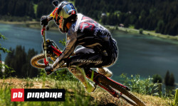
Inside the Tape: Razor-Thin Timing & a Massive Qualifying Shakeup in Lenzerheide
Jun 19, 2026 from pinkbike.com
Ben Cathro and Innes Graham go inside the tape to analyze the new lines, catastrophic crashes, and unexpected top-tier dropouts in Switzerland.

They've Made It Even Faster! | Track Preview - Lenzerheide 2026
Jun 18, 2026 from pinkbike.com
Round 4 of the Downhill World Series shifts to Switzerland, where fresh tunings are sending riders into technical rock gardens with unprecedented...
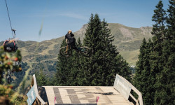
Video: Measuring Lenzerheide’s Biggest World Cup Jumps with a Tape Measure
Jun 17, 2026 from pinkbike.com
Charlie Coquillard takes a tape measure down the high-speed Swiss track to benchmark massive gaps and analyze the brand-new 2026 course sections.
Lenzerheide Celebrates 10 Years of World Cup Madness to Kick Off "Bike Kingdom" Season
Jun 9, 2026 from pinkbike.com
The UCI Mountain Bike World Series returns to Switzerland on June 19–21, bringing elite cross-country and downhill battles alongside a massive...
Popular Trail Networks
view all areas »Sub Regions
- Aargau Kanton (434)
- Appenzell Ausserrhoden (12)
- Appenzell Innerrhoden (55)
- Basel-Landschaft (150)
- Basel-Stadt (22)
- Bern Kanton (958)
- Fribourg Canton (175)
- Genève Canton (35)
- Glarus Kanton (137)
- Graubünden (2,317)
- Jura (122)
- Luzern Kanton (175)
- Neuchâtel Canton (158)
- Nidwalden (106)
- Obwalden (195)
- Schaffhausen Kanton (25)
- Schwyz Kanton (263)
- Solothurn Kanton (486)
- St. Gallen Kanton (778)
- Thurgau (149)
- Ticino (1,037)
- Uri (156)
- Valais (3,089)
- Vaud Canton (368)
- Zug Kanton (183)
- Zürich Kanton (784)
Popular Switzerland Mountain Biking Trails
• 90 ★ 4.9 • 4,081 ft • 0 ft • 1,912 •
Highly rated popular blue difficulty singletrack. This multi-use trail can be used downhill primary and has a easy overall physical rating with a 0 ft green climb. Trail visibility is always easy to follow. On average it takes minutes to complete this trail.
• 100 ★ 3.8 • 1 mile • 0 ft • 1,757 •
Flow Country Trail im weniger steilen Gelände mit viel Flow, Kurven und kleinen Sprüngen, ideal für Einsteiger und Familien. is a beginner and warm-up track. With her small jumps and flowing curves she is the right place to practice...
• 70 ★ 4.7 • 5 miles • 825 ft • 1,651 •
Vom Strelapass führt ein schöner Singletrail weiter über die Latschüelfurgga zur Chörbschhornhütte. Wer noch nicht genug hat steigt zu Fuss hoch zum Chörbschhorngipfel. Von der Chörbschhornhütte folgt das Highlight des Trails....
• 45 ★ 4.3 • 1 mile • 0 ft • 1,512 •
Anspruchsvolle, weltcuptaugliche Downhillstrecke im steilen Gelände mit grossen Sprüngen, Drops, Anlegern und North Shore Elementen.
• 100 ★ 4.0 • 3,622 ft • 0 ft • 1,377 •
Popular red difficulty singletrack. This mountain bike primary trail can be used downhill only. On average it takes 4 minutes to complete this trail.
• 100 ★ 4.7 • 3 miles • 3 ft • 1,314 •
Die Strecke wurde 2015 von der Trail Crew saniert. Dies ist der erste Teil des Alps Epic Trail Davos. Der Startpunkt kann bequem mit der erreicht werden. Bitte aus Rücksicht auf unsere Wildtiere diesen Trail zwischen 18:30 und 08:00...
Switzerland Mountain Bike Routes
Alps Epic Trail Davos (IMBA Epic) Featured
★ 4.4 • 24 miles • 2,601 ft • 13 • Point to Point •
: This ride features stunning views of the Alps with biergartens along the way.The majority of the route...
Häxutrail Bike #158 Featured
★ 5.0 • 4 miles • 30 ft • 8 • Point to Point •
The trail begins with a ride down a forest track to approximately 1950m above sea level (ASL) where the...
Passo del Gallo - Val Mora Featured
★ 5.0 • 23 miles • 2,745 ft • 14 • Loop •
An extension of the classic tour "Val Mora - A Feeling of Canadian Wilderness", for those who are looking...
Val Müstair Bike #449 Featured
★ 5.0 • 13 miles • 1,263 ft • 16 • Shuttled •
Es gibt keinen besseren Weg, um das Val Müstair kennenzulernen. Die Tour führt über 21 km und 1000...
Jeizi Enduro #118 Featured
★ 5.0 • 8 miles • 3,164 ft • 3 • Shuttled •
Exposed, demanding passages, magnificent views of the valley, rustic hamlets and forests: the descent from...
Visp-Zermatt Bike #150 Featured
★ 5.0 • 23 miles • 4,649 ft • 7 • Point to Point •
Paved: 18km Forest Track: 9km SingleTrail: 11km
Photos of Switzerland Mountain Bike
Videos of Switzerland Mountain Bike
trail: Tomilser lll
0:52 |
7 |
May 28, 2026
trail: Dirauls
0:31 |
8 |
May 28, 2026

trail: Leitistock
0:49 |
8 |
May 25, 2026
trail: Nord Black Line
0:04 |
31 |
May 13, 2026
trail: Alt Uetliberg
0:38 |
11 |
May 1, 2026
0:09 |
12 |
Apr 28, 2026
trail: Mozentobel
2:58 |
11 |
Apr 27, 2026
trail: Dieba Cliffside
0:23 |
13 |
Apr 27, 2026
National Scenic Trails & Official Routes
-
Lugano Bike #66
- Mountain Bike
- E-Bike
-
St.-Gotthard Fünf-Pässe Bike #85
- Mountain Bike
- E-Bike
-
St.-Gotthard Vier-Pässe Bike #84
- Mountain Bike
- E-Bike
-
Trans-Altarezia Bike #32
- Mountain Bike
- E-Bike


Recent Comments
| username | type | title | comment | date |
|---|---|---|---|---|
| trail | Mostly a hiking trail, not maintained, not... | Jun 28, 2026 @ 1:33pm 8 hours | ||
| trail | Sehr einfach zu fahren, kein Bergtrail, eher... | Jun 28, 2026 @ 11:18am 10 hours | ||
| trail | Top Trail, just amazing | Jun 27, 2026 @ 1:00pm 1 day | ||
| trail | Vielen Dank an Trail Builders, guys - wir... | Jun 27, 2026 @ 11:04am 1 day | ||
| trail | Just rode this trail with my daughter late in... | Jun 27, 2026 @ 8:57am 2 days |
Bike & Skill Parks
| name | type | city | rating |
|---|---|---|---|
| Biketrails Flims Laax | bike park | Flims LAAX | |
| Bike Kingdom Park | bike park | Arosa Lenzerheide | |
| Verbier Bike Park | bike park | Verbier | |
| Alpen Bikepark | bike park | Chur | |
| Crans-Montana Bikepark | bike park | Crans-Montana |
Upcoming Local Events
Activity Type Stats
| activitytype | trails | distance | descent | descent distance | total vertical | rating | global rank | state rank | photos | reports | routes | ridelogs |
|---|---|---|---|---|---|---|---|---|---|---|---|---|
| Mountain Bike | 12,243 | 9,219 miles | 825 miles | 5,661 miles | 11,106 ft | #13 | 15,474 | 78,579 | 501 | 725,843 | ||
| E-Bike | 10,887 | 8,296 miles | 718 miles | 5,004 miles | 10,036 ft | #10 | 160 | 74,478 | 369 | 112,735 | ||
| Gravel Bike | 2,327 | 3,101 miles | 409,373 ft | 917 miles | 10,036 ft | #9 | 4 | 2,978 | 21 | 9,571 | ||
| Adaptive Bike | 510 | 746 miles | 90,354 ft | 208 miles | 8,612 ft | #15 | 4,020 | 2 | 24 | |||
| Winter Fat Bike | 7 | 3 miles | 574 ft | 4,396 ft | 1,768 ft | #16 | 619 | 6 | ||||
| Horse | 9 | 4 miles | 361 ft | 1 mile | 3,192 ft | #19 | 5,604 | 13 | ||||
| Hike | 11,887 | 9,145 miles | 805 miles | 5,499 miles | 11,106 ft | #10 | 64 | 75,215 | 93 | 73,504 | ||
| Trail Running | 11,887 | 9,145 miles | 805 miles | 5,500 miles | 11,106 ft | #10 | 12 | 75,166 | 85 | 28,474 | ||
| Snowshoe | 18 | 31 miles | 8,025 ft | 12 miles | 8,146 ft | #6 | 2,822 | 1,731 | ||||
| Downhill Ski | 535 | 377 miles | 318,025 ft | 355 miles | 10,909 ft | #6 | 2,572 | 46,529 | ||||
| Backcountry Ski | 138 | 340 miles | 87,100 ft | 106 miles | 12,005 ft | #6 | 2 | 2,795 | 27,713 | |||
| Nordic Ski | 41 | 58 miles | 4,304 ft | 24 miles | 8,146 ft | #9 | 2,776 | 23,506 |
Activities
- Switzerland Mountain Biking Trails
- Switzerland E-Biking Trails
- Switzerland Gravel Biking Trails
- Switzerland Adaptive Biking Trails
- Switzerland Winter Fat Biking Trails
- Switzerland Horseback Trails
- Switzerland Hiking Trails
- Switzerland Trail Running Trails
- Switzerland Snowshoeing Trails
- Switzerland Skiing Trails
- Switzerland Backcountry Skiing Trails
- Switzerland Nordic Skiing Trails
Trails
Points of Interest
- Mt Pisgah Campgrounds Camping
- Capanna Gambarögn Lodge
- Little Arsenic Campground Camping
- First drop TTF
- Aussichtspunkt Wiesner Viadukt Viewpoint
- Information panel Bikepark Bülach
- Camping Rinerlodge
- Kasthofer-Gedenkstätte (Monument) Sight
- Repeater Campground Camping
- Rock Slabs TTF
- Grand Gendarme (14,465 ft)
- Dom (14,032 ft)
- Aiguille du Croissant (13,868 ft)
- By canadaka
 Trailforks & contributors
 - Admins: swiss, trailpapst
- #3151 - 167,211 views
- switzerland activity log | embed map of Switzerland mountain bike trails | switzerland mountain biking points of interest polygons
Downloading of trail gps tracks in kml & gpx formats is enabled for Switzerland.
You must login to download files.