close
-
Layers w
- Weather Layers
- Pro
- Pro
- Pro
- Pro
- Pro
- Pro
- More Layers
- Pro
- Pro
- Pro
- Pro
-
Upgrade to

3D
Trail Conditions
- Unknown
- Snow Groomed
- Snow Packed
- Snow Covered
- Snow Cover Partial
- Freeze/thaw Cycle
- Icy
- Prevalent Mud
- Wet
- Variable
- Ideal
- Dry
- Very Dry
Trail Flow (Ridden Direction)
Trailforks scans users ridelogs to determine the most popular direction each trail is ridden. A good flowing trail network will have most trails flowing in a single direction according to their intension.
The colour categories are based on what percentage of riders are riding a trail in its intended direction.
The colour categories are based on what percentage of riders are riding a trail in its intended direction.
- > 96%
- > 90%
- > 80%
- > 70%
- > 50%
- < 50%
- bi-directional trail
- no data
Trail Last Ridden
Trailforks scans ridelogs to determine the last time a trail was ridden.
- < 2 days
- < 1 week
- < 2 weeks
- < 1 month
- < 6 months
- > 6 months
Trail Ridden Direction
The intended direction a trail should be ridden.
- Downhill Only
- Downhill Primary
- Both Directions
- Uphill Primary
- Uphill Only
- One Direction
Contribute Details
Colors indicate trail is missing specified detail.
- Description
- Photos
- Description & Photos
- Videos
Trail Popularity ?
Trailforks scans ridelogs to determine which trails are ridden the most in the last 9 months.
Trails are compared with nearby trails in the same city region with a possible 25 colour shades.
Think of this as a heatmap, more rides = more kinetic energy = warmer colors.
- most popular
- popular
- less popular
- not popular
ATV/ORV/OHV Filter
Max Vehicle Width
inches
US Cell Coverage
Legend

Radar Time
Activity Recordings
Trailforks uses anonymized public activity data.
?
Activity Recordings
Trailforks uses anonymized public activity data.
?
Personal Heatmap
▶
Activity Types
all
/
none
▶
Options
2
Date range
month
–
Winter Trails
Warning
A routing network for winter maps does not exist. Selecting trails using the winter trails layer has been disabled.
Missing Trails
Most Popular
Least Popular
Trails are colored based on popularity. The more popular a trail is, the more red. Less popular trails trend towards green.
Jump Magnitude Heatmap
Heatmap of where riders jump on trails. Zoom in to see individual jumps, click circles to view jump details.
BC Backroad Status
![map legend]()
Service Road Atlas is a free to use, community-driven service for viewing and creating reports on the numerous back-country service roads around B.C. and Alberta.

Slope Aspect
Direction the slope faces
Trails Deemphasized
Trails are shown in grey.
Only show trails with no bike usage.
Suggested Layers
Based on selected activity type
Save the current map location and zoom level as your default home location whenever this page is loaded.
Save
No description for Sylmar has been added yet!
Login or register to submit one.
Activities Click to view
- Mountain Bike
18 trails
- E-Bike
13 trails
- Winter Fat Bike
0 trails
- Horse
6 trails
- Hike
9 trails
- Trail Running
9 trails
Region Details
- 5
- 2
- 2
- 6
- 1
Region Status
Caution as of Mar 28, 2026Stats
- Avg Trail Rating
- Trails (view details)
- 16
- Trails Mountain Bike
- 18
- Trails E-Bike
- 13
- Trails Horse
- 6
- Trails Hike
- 9
- Trails Trail Running
- 9
- Total Distance
- 18 miles
- Total Descent Distance
- 9 miles
- Total Descent
- 6,479 ft
- Total Vertical
- 2,338 ft
- Highest Trailhead
- 3,737 ft
- Reports
- 355
- Photos
- 29
- Ridden Counter
- 414
Popular Sylmar Mountain Biking Trails
• 80 ★ 4.3 • 2 miles • 5 ft • 40 •
The Bee Canyon Trail starts at the northern tip of O'Melveny Park, and leads north through Bee Canyon for a short distance, then turns steeply up the mountainside and climbs up to the near the summit of Mission Point. The trail is very...
• 75 ★ 5.0 • 1 mile • 0 ft • 24 •
Popular black diamond difficulty singletrack. This mountain bike primary trail can be used downhill only and has a hard overall physical rating with a 0 ft blue climb. Trail visibility is sometimes hard to follow. On average it takes 11 minutes to complete this trail.
• 70 ★ 0.0 • 3 miles • 819 ft • 20 •
Kagel Truck Trail is a single and double track link from Lopez Canyon Road (paved) to Kagel Mountain Road (dirt / unpaved). From Lopez Canyon Road, access the trail near the toilet in the parking lot.
• 30 ★ 3.0 • 1 mile • 14 ft • 13 •
Less popular black diamond difficulty singletrack. This mountain bike primary trail. On average it takes 11 minutes to complete this trail.
• 50 ★ 3.0 • 4,078 ft • 51 ft • 12 •
The Olive View Connector leads from the Wilson Debris Basin trailhead, through a picnic area and a network of side trails, then climbs a short grade to connect with the Wilson Canyon Truck Trail.
• 5 ★ 2.4 • 2 miles • 419 ft • 4 •
Fish Tank Loop is a mellow side-trip in the upper part of . The trail starts and ends on Sunshine Canyon Motorway, and descends to an old stock tank that is filled with goldfish. Climbing is moderate, setting is peaceful.
• 35 ★ 0.0 • 2,362 ft • 0 ft • 3 •
Less popular black diamond difficulty singletrack. This mountain bike primary trail can be used both directions. On average it takes 1 minutes to complete this trail.
Photos of Sylmar Mountain Bike
Videos of Sylmar Mountain Bike
trail: Freight Train
0:32 |
160 |
Mar 14, 2022
trail: Mission Point Summit Spur
0:33 |
11 |
Mar 14, 2022
2:16 |
10 |
Mar 14, 2022
trail: Mission Down
2:06 |
158 |
Sep 27, 2018
youtuber
![Bee Canyon Trail - Mountain Biking - Granada...]()
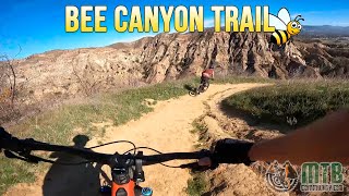
trail: Bee Canyon Trail
4:43 |
631 |
Nov 27, 2022 , Sylmar
youtuber
![Redline Trail - Mountain Biking - San Fernando, CA]()
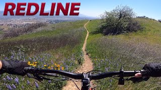
trail: Mission Down
3:30 |
710 |
Mar 14, 2022 , Sylmar
Recent Trail Reports
| status | trail | date | condition | info | user |
|---|---|---|---|---|---|
| Veterans Firebreak | Mar 28, 2026 @ 1:17pm (America/Los_Angeles) Mar 28, 2026 | Variable | DudeMotoGP | ||
| Mario A DeCampos Trail | Jul 1, 2025 @ 6:57am Jul 1, 2025 | Dry | AppleJack76 | ||
| Mario A DeCampos Trail (OLD SEG) | Jun 11, 2025 @ 6:12am Jun 11, 2025 | Dry | AppleJack76 | ||
| Bee Canyon Trail | Jun 4, 2025 @ 4:03pm Jun 4, 2025 | Dry | AppleJack76 | ||
| Mission Point Summit Spur | Jun 4, 2025 @ 4:03pm Jun 4, 2025 | Dry | AppleJack76 | ||
| Olive View Connector | May 25, 2025 @ 9:00am May 25, 2025 | Very Dry | AppleJack76 | ||
| Mission Down | Apr 9, 2025 @ 9:48am Apr 9, 2025 | Dry | clarkperry | ||
| Wilson Canyon Truck Trail | Apr 6, 2025 @ 10:17am Apr 6, 2025 | Variable | malonebenjamen | ||
| Kagel Truck Trail - Upper Portion | Mar 3, 2025 @ 6:41pm Mar 3, 2025 | Dry | HDM94 | ||
| Boulder | May 11, 2024 @ 7:33pm May 11, 2024 | Dry | Jordi1978 |
Activity Feed
| username | action | type | title | date |
|---|---|---|---|---|
| findingpc | wishlist | trail | activity #97099546 | Jun 16, 2026 @ 4:31am 1 day |
| doublenickelsclub | add | photo | activity #95369559 | May 23, 2026 @ 5:47pm May 23, 2026 |
| DudeMotoGP | add | report | activity #91685867 | Mar 31, 2026 @ 7:07pm Mar 31, 2026 |
| opiyoj1 | wishlist | region | activity #90129567 | Mar 7, 2026 @ 8:47am Mar 7, 2026 |
| RedMisty | add | trail | activity #87526835 | Jan 20, 2026 @ 8:13am Jan 20, 2026 |
Recent Comments
| username | type | title | comment | date |
|---|---|---|---|---|
| trail | More like a blue trail with a few sections of... | Jun 28, 2025 @ 12:24pm Jun 28, 2025 | ||
| trail | Pretty much just feels like a steep fire road.... | Sep 19, 2024 @ 10:00am Sep 19, 2024 | ||
| trail | Way too steep to climb, even with e bike.... | Sep 19, 2024 @ 9:12am Sep 19, 2024 | ||
| trail | for the ones that like down hill challenge it... | Nov 26, 2022 @ 6:01pm Nov 26, 2022 | ||
| trail | I started to ride down it then realized how... | Mar 14, 2022 @ 5:06pm Mar 14, 2022 |
Local Badges
-

Epic Mountain Bike Climb 2k0 awarded -

Climbing 10k Badge1 awarded -

Mountain Biking 100k Badge0 awarded -

Epic Ride Descent 2k0 awarded -

Descent 10k Badge1 awarded -

Descent 100k Badge0 awarded
Activity Type Stats
| activitytype | trails | distance | descent | descent distance | total vertical | rating | global rank | state rank | photos | reports | routes | ridelogs |
|---|---|---|---|---|---|---|---|---|---|---|---|---|
| Mountain Bike | 18 | 18 miles | 6,480 ft | 9 miles | 2,339 ft | #6,761 | #2,260 | 25 | 355 | 262 | ||
| E-Bike | 13 | 12 miles | 6,135 ft | 9 miles | 2,339 ft | #5,696 | #1,758 | 347 | 237 | |||
| Horse | 6 | 13 miles | 2,320 ft | 5 miles | 2,228 ft | #2,423 | #1,339 | 8 | ||||
| Hike | 9 | 13 miles | 2,320 ft | 5 miles | 2,228 ft | #9,868 | #3,490 | 4 | 349 | 46 | ||
| Trail Running | 9 | 13 miles | 2,320 ft | 5 miles | 2,228 ft | #9,389 | #3,177 | 349 | 12 |
Frequently Asked Questions About Sylmar
▼
What are the highest rated mountain biking trails in Sylmar?
The highest rated mountain biking trails in Sylmar are:
- Mission Down (4.1/5)
- Bee Canyon Trail (4.1/5)
- Olive View Connector (3.8/5)
- Freight Train (3.8/5)
- Fish Tank Loop (3.4/5)
▼
What is the best time of the year to ride in Sylmar?
Based on ride log data, the most popular months to ride in Sylmar are:
- November (4 activities)
- September (3 activities)
- July (2 activities)
▼
Where can I park to ride in Sylmar?
There are 1 parking locations listed in Sylmar. The most popular parking spots are:
▼
What is the longest trail in Sylmar?
The longest trail in Sylmar is Kagel Truck Trail - Upper Portion at 2.7 miles. View all trails sorted by distance.
- By thomasjkenney1024
 & contributors
 - Admins: CORBA
- #48266 - 2,739 views
- sylmar activity log | embed map of Sylmar mountain bike trails | sylmar mountain biking points of interest
Downloading of trail gps tracks in kml & gpx formats is enabled for Sylmar.
You must login to download files.