close
-
Layers w
- Weather Layers
- Pro
- Pro
- Pro
- Pro
- Pro
- Pro
- More Layers
- Pro
- Pro
- Pro
- Pro
-
Upgrade to

3D
Trail Conditions
- Unknown
- Snow Groomed
- Snow Packed
- Snow Covered
- Snow Cover Partial
- Freeze/thaw Cycle
- Icy
- Prevalent Mud
- Wet
- Variable
- Ideal
- Dry
- Very Dry
Trail Flow (Ridden Direction)
Trailforks scans users ridelogs to determine the most popular direction each trail is ridden. A good flowing trail network will have most trails flowing in a single direction according to their intension.
The colour categories are based on what percentage of riders are riding a trail in its intended direction.
The colour categories are based on what percentage of riders are riding a trail in its intended direction.
- > 96%
- > 90%
- > 80%
- > 70%
- > 50%
- < 50%
- bi-directional trail
- no data
Trail Last Ridden
Trailforks scans ridelogs to determine the last time a trail was ridden.
- < 2 days
- < 1 week
- < 2 weeks
- < 1 month
- < 6 months
- > 6 months
Trail Ridden Direction
The intended direction a trail should be ridden.
- Downhill Only
- Downhill Primary
- Both Directions
- Uphill Primary
- Uphill Only
- One Direction
Contribute Details
Colors indicate trail is missing specified detail.
- Description
- Photos
- Description & Photos
- Videos
Trail Popularity ?
Trailforks scans ridelogs to determine which trails are ridden the most in the last 9 months.
Trails are compared with nearby trails in the same city region with a possible 25 colour shades.
Think of this as a heatmap, more rides = more kinetic energy = warmer colors.
- most popular
- popular
- less popular
- not popular
ATV/ORV/OHV Filter
Max Vehicle Width
inches
US Cell Coverage
Legend

Radar Time
Activity Recordings
Trailforks uses anonymized public activity data.
?
Activity Recordings
Trailforks uses anonymized public activity data.
?
Personal Heatmap
▶
Activity Types
all
/
none
▶
Options
2
Date range
month
–
Winter Trails
Warning
A routing network for winter maps does not exist. Selecting trails using the winter trails layer has been disabled.
Missing Trails
Most Popular
Least Popular
Trails are colored based on popularity. The more popular a trail is, the more red. Less popular trails trend towards green.
Jump Magnitude Heatmap
Heatmap of where riders jump on trails. Zoom in to see individual jumps, click circles to view jump details.
BC Backroad Status
![map legend]()
Service Road Atlas is a free to use, community-driven service for viewing and creating reports on the numerous back-country service roads around B.C. and Alberta.

Slope Aspect
Direction the slope faces
Trails Deemphasized
Trails are shown in grey.
Only show trails with no bike usage.
Suggested Layers
Based on selected activity type
Save the current map location and zoom level as your default home location whenever this page is loaded.
Save
No description for Table Mountain has been added yet!
Login or register to submit one.
 google parking directions
google parking directions Region Supporters & Maintainers
Activities Click to view
- Mountain Bike
53 trails
- E-Bike
43 trails
- Horse
16 trails
- Hike
56 trails
- Trail Running
56 trails
- Dirtbike/Moto
30 trails
- ATV/ORV/OHV
10 trails
Region Details
- 26
- 2
- 10
- 15
Region Status
Caution as of 2 daysStats
- Avg Trail Rating
- Trails (view details)
- 57
- Trails Mountain Bike
- 53
- Trails E-Bike
- 43
- Trails Horse
- 16
- Trails Hike
- 56
- Trails Trail Running
- 56
- Trails Dirtbike/Moto
- 30
- Trails Observed Trials
- 1
- Trails ATV/ORV/OHV
- 10
- Trails Snowshoe
- 1
- Trails Backcountry Ski
- 2
- Trails Nordic Ski
- 1
- Total Distance
- 193 miles
- Total Descent
- 36,893 ft
- Total Vertical
- 4,127 ft
- Highest Trailhead
- 6,364 ft
- Reports
- 183
- Photos
- 139
- Ridden Counter
- 350
Popular Table Mountain Mountain Biking Trails
• 70 ★ 4.4 • 8 miles • 1,336 ft • 63 •
Loose, dry and rocky. Make sure you take enough water for about 3 hours of work in hot dry conditions. There is no water between Haney Meadows and . TRT loses altitude grudgingly, with quite a few up-pitches. trail also follows a ridge...
• 55 ★ 3.4 • 2 miles • 26 ft • 13 •
This short, steep trail offers views of , Miller Peak, Navaho Peak and the Enchantments. It is especially scenic in the fall when the western larch needles turn bright yellow. It provides access to the high meadow parkland country atop .
• 5 ★ 4.0 • 3 miles • 714 ft • 13 •
The Mount Lillian Trail begins at Upper Naneum Trail #4W312 and ends at Forest Road 9712. Begins at the north end of the Ken Wilcox Horse Campground and follows the boundary of the county line (between Chelan and Kittitas counties),...
• 5 ★ 3.0 • 3 miles • 823 ft • 11 •
The Old Ellensburg Trail begins at Forest Road 9712 and ends at the Forest Boundary. From Road 9712, the trail crosses , skirts Haney Meadow, continues through a low saddle, descends to and crosses Howard Creek, then climbs to trail end...
• 5 ★ 3.0 • 4 miles • 0 ft • 11 •
Less popular black diamond difficulty singletrack. This mountain bike primary trail can be used downhill primary. On average it takes 48 minutes to complete this trail.
• 5 ★ 0.0 • 2,359 ft • 89 ft • 9 • • horse
Less popular green difficulty singletrack. This horse primary trail can be used both directions. On average it takes 4 minutes to complete this trail.
• 5 ★ 3.0 • 3 miles • 513 ft • 8 •
#1372 | Note: GPS track of this trail requested. Please upload or send to admins: boxxerace or jmahler The begins at Forest Road 9712 and ends at . The trailhead is at the highpoint of the trail. From here the trail descends along the...
• 5 ★ 3.0 • 2 miles • 349 ft • 6 •
Less popular black diamond difficulty singletrack. This mountain bike primary trail can be used both directions. On average it takes 28 minutes to complete this trail.
Table Mountain Mountain Bike Routes
26 miles • 2,690 ft • 11 •
FS9714 - Teanaway Campground Gravel and Single Track
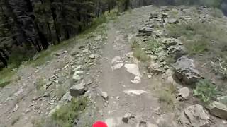
Photos of Table Mountain Mountain Bike
Videos of Table Mountain Mountain Bike

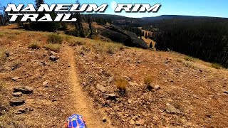
trail: Tronsen Ridge
10:56 |
144 |
Jan 4, 2025 , Ellensburg
trail: Tronsen Ridge
10:38 |
99 |
Jan 4, 2025 , Ellensburg
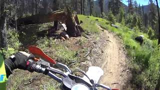
trail: Naneum Creek Trail
12:58 |
56 |
Jan 4, 2025 , Ellensburg
trail: Tronsen Meadow Trail #1205
7:54 |
59 |
Jan 4, 2025 , Ellensburg
Current Trail Warnings
| status | trail | date | condition | user | info |
|---|---|---|---|---|---|
| Jeep Rd 4W312 | Jun 6, 2026 @ 6:00pm (America/Los_Angeles) Jun 6, 2026 | Dry | i-g-o-r | Piles of blowdowns | |
| Mount Lillian Trail #1601 | Jun 6, 2026 @ 5:59pm (America/Los_Angeles) Jun 6, 2026 | Unknown | i-g-o-r | Only hiked one mile up from Tronsen... | |
| Tronsen Meadow Trail #1205 | Jun 6, 2026 @ 5:58pm (America/Los_Angeles) Jun 6, 2026 | Dry | i-g-o-r | The first mile has been cleared but... |
Recent Trail Reports
| status | trail | date | condition | info | user |
|---|---|---|---|---|---|
| Tronsen Ridge | May 17, 2026 @ 8:12pm (America/Los_Angeles) May 17, 2026 | Dry | i-g-o-r | ||
| Old Ellensburg Trail #1373 | May 12, 2026 @ 8:26pm (America/Los_Angeles) May 12, 2026 | Unknown | lizryen | ||
| Beehive Road (9712) | May 12, 2026 @ 6:49am (America/Los_Angeles) May 12, 2026 | Unknown | lizryen | ||
| Howard Creek Tie Trail 1372.1 | Aug 21, 2025 @ 9:57am Aug 21, 2025 | Dry | Rbeukema | ||
| Old Ellensburg Road | Aug 21, 2025 @ 9:57am Aug 21, 2025 | Very Dry | Rbeukema | ||
| Wilson Creek Trail 1387 | Jul 21, 2025 @ 11:07pm Jul 21, 2025 | Very Dry | MBikeRider | ||
| FS Road 7240 | Aug 8, 2024 @ 1:31am Aug 8, 2024 | Dry | Rbeukema | ||
| Naneum Wilson Trail 1371 | Jul 17, 2024 @ 3:37pm Jul 17, 2024 | Dry | 8oCiRGMD | ||
| Naneum Creek Trail #1381 | Jul 17, 2024 @ 3:36pm Jul 17, 2024 | Dry | 8oCiRGMD | ||
| Table Mountain Trail | Jul 17, 2024 @ 3:34pm Jul 17, 2024 | Dry | 8oCiRGMD |
Activity Feed
| username | action | type | title | date |
|---|---|---|---|---|
| i-g-o-r | add | report | activity #96420187 and 3 more | Jun 6, 2026 @ 5:57pm Jun 6, 2026 |
| epicdayoff | ridden | trail | activity #96397024 | Jun 6, 2026 @ 12:27pm Jun 6, 2026 |
| i-g-o-r | add | report | activity #94957389 | May 17, 2026 @ 8:12pm May 17, 2026 |
| lizryen | add | report | activity #94606770 | May 12, 2026 @ 8:26pm May 12, 2026 |
| lizryen | add | report | activity #94555447 | May 12, 2026 @ 6:49am May 12, 2026 |
Recent Comments
| username | type | title | comment | date |
|---|---|---|---|---|
| trail | Rode the section from pipeline to forest... | Oct 22, 2023 @ 10:07pm Oct 22, 2023 | ||
| report | Thanks for the update MBikeRider! Did you... | Oct 16, 2023 @ 12:32pm Oct 16, 2023 | ||
| report | This reviewer missed the start of the trail.... | Oct 16, 2023 @ 11:47am Oct 16, 2023 | ||
| report | This reviewer missed the start of the trail.... | Oct 16, 2023 @ 11:46am Oct 16, 2023 | ||
| report | This reviewer missed the start of the trail.... | Oct 16, 2023 @ 11:46am Oct 16, 2023 |
Nearby Areas
| name | distance | ||||
|---|---|---|---|---|---|
| Devils - Mission | 3 | 11 | 3 | 5.1 km | |
| Squilchuck State Park | 5 | 2 | 7.6 km | ||
| #2 Canyon | 7 | 11 | 3 | 9.2 km | |
| Dry Gulch Preserve | 1 | 11.6 km | |||
| Saddle Rock Natural Area | 1 | 9 | 1 | 12.1 km |
Local Badges
-

Completionist0 awarded
Local Products
Activity Type Stats
| activitytype | trails | distance | descent | descent distance | total vertical | rating | global rank | state rank | photos | reports | routes | ridelogs |
|---|---|---|---|---|---|---|---|---|---|---|---|---|
| Mountain Bike | 53 | 188 miles | 36,106 ft | 92 miles | 4,127 ft | #1,369 | #467 | 131 | 183 | 1 | 159 | |
| E-Bike | 43 | 156 miles | 29,019 ft | 75 miles | 4,127 ft | #778 | #628 | 138 | 13 | |||
| Horse | 16 | 61 miles | 8,694 ft | 25 miles | 3,435 ft | #882 | #463 | 73 | 1 | |||
| Hike | 56 | 192 miles | 36,591 ft | 93 miles | 4,127 ft | #787 | #398 | 185 | 109 | |||
| Trail Running | 56 | 192 miles | 36,591 ft | 93 miles | 4,127 ft | #397 | #170 | 185 | 15 | |||
| Dirtbike/Moto | 30 | 115 miles | 20,446 ft | 52 miles | 3,980 ft | #208 | #88 | 1 | 99 | 9 | ||
| Observed Trials | 1 | 1 mile | 10 ft | 558 ft | 640 ft | 7 | ||||||
| ATV/ORV/OHV | 10 | 51 miles | 9,692 ft | 28 miles | 3,474 ft | #406 | #121 | 52 | ||||
| Snowshoe | 1 | 3,973 ft | 302 ft | 3,510 ft | 302 ft | |||||||
| Backcountry Ski | 2 | 2 miles | 1,486 ft | 2 miles | 1,598 ft | 35 | ||||||
| Nordic Ski | 1 | 2 miles | 1,184 ft | 2 miles | 1,165 ft |
Frequently Asked Questions About Table Mountain
▼
What are the highest rated mountain biking trails in Table Mountain?
The highest rated mountain biking trails in Table Mountain are:
- Tronsen Ridge (4.2/5)
- Naneum Creek Trail (4/5)
- Grass Camp Trail #1219 (4/5)
- Mount Lillian Trail #1601 (4/5)
- Owl Creek Trail 1371.2 (4/5)
▼
What is the best time of the year to ride in Table Mountain?
Based on ride log data, the most popular months to ride in Table Mountain are:
- August (2 activities)
- May (2 activities)
- October (1 activities)
▼
Where can I park to ride in Table Mountain?
▼
What is the longest trail in Table Mountain?
The longest trail in Table Mountain is Tronsen Ridge at 7.5 miles. View all trails sorted by distance.
Activities
Trails
- By petkatmat & contributors
- Admins: EMBA-KC
- #26390 - 5,320 views
- table mountain activity log | embed map of Table Mountain mountain bike trails | table mountain mountain biking points of interest
Downloading of trail gps tracks in kml & gpx formats is enabled for Table Mountain.
You must login to download files.