close
-
Layers w
- Weather Layers
- Pro
- Pro
- Pro
- Pro
- Pro
- Pro
- More Layers
- Pro
- Pro
- Pro
- Pro
-
Upgrade to

3D
Trail Conditions
- Unknown
- Snow Groomed
- Snow Packed
- Snow Covered
- Snow Cover Partial
- Freeze/thaw Cycle
- Icy
- Prevalent Mud
- Wet
- Variable
- Ideal
- Dry
- Very Dry
Trail Flow (Ridden Direction)
Trailforks scans users ridelogs to determine the most popular direction each trail is ridden. A good flowing trail network will have most trails flowing in a single direction according to their intension.
The colour categories are based on what percentage of riders are riding a trail in its intended direction.
The colour categories are based on what percentage of riders are riding a trail in its intended direction.
- > 96%
- > 90%
- > 80%
- > 70%
- > 50%
- < 50%
- bi-directional trail
- no data
Trail Last Ridden
Trailforks scans ridelogs to determine the last time a trail was ridden.
- < 2 days
- < 1 week
- < 2 weeks
- < 1 month
- < 6 months
- > 6 months
Trail Ridden Direction
The intended direction a trail should be ridden.
- Downhill Only
- Downhill Primary
- Both Directions
- Uphill Primary
- Uphill Only
- One Direction
Contribute Details
Colors indicate trail is missing specified detail.
- Description
- Photos
- Description & Photos
- Videos
Trail Popularity ?
Trailforks scans ridelogs to determine which trails are ridden the most in the last 9 months.
Trails are compared with nearby trails in the same city region with a possible 25 colour shades.
Think of this as a heatmap, more rides = more kinetic energy = warmer colors.
- most popular
- popular
- less popular
- not popular
ATV/ORV/OHV Filter
Max Vehicle Width
inches
US Cell Coverage
Legend

Radar Time
Activity Recordings
Trailforks uses anonymized public activity data.
?
Activity Recordings
Trailforks uses anonymized public activity data.
?
Personal Heatmap
▶
Activity Types
all
/
none
▶
Options
2
Date range
month
–
Winter Trails
Warning
A routing network for winter maps does not exist. Selecting trails using the winter trails layer has been disabled.
Missing Trails
Most Popular
Least Popular
Trails are colored based on popularity. The more popular a trail is, the more red. Less popular trails trend towards green.
Jump Magnitude Heatmap
Heatmap of where riders jump on trails. Zoom in to see individual jumps, click circles to view jump details.
BC Backroad Status
![map legend]()
Service Road Atlas is a free to use, community-driven service for viewing and creating reports on the numerous back-country service roads around B.C. and Alberta.

Slope Aspect
Direction the slope faces
Trails Deemphasized
Trails are shown in grey.
Only show trails with no bike usage.
Suggested Layers
Based on selected activity type
Save the current map location and zoom level as your default home location whenever this page is loaded.
SaveTallahassee is home to some of the best mountain biking in Florida with 100+ miles of in town trails as diverse as they come. For good reason the Tallahassee Mountain Bike Association’s motto is “Not all of Florida is Flat”. The varying terrain, trail connectivity and extensive tree canopy provides a riding experience that is unmatched anywhere else in Florida.
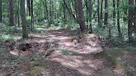
For a fun, flowy experience ride Munson Hills on the south side of town. Five miles south of downtown, Munson Hills trail is an eight-mile loop that is nestled in the northeast tip of the Apalachicola National Forest, Florida’s largest national forest. Hop on the historical St. Marks Trail from downtown and ride straight to the trailhead.
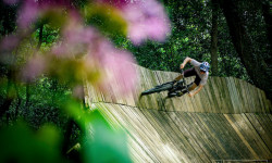
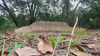
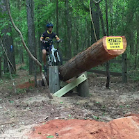
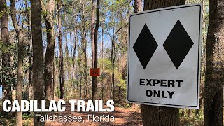
For a more technical experience, try Tom Brown Park. You’ll find Tom Brown just five miles east of downtown. From kayaking to Frisbee golf, Tom Brown has something for everyone and the most impressive feature is the park’s extensive mountain bike trails. Tom Brown has two flow trails, namely Kudzilla and the Gun Range Loop, both riddled with jumps and technical features.
Adjacent to Maclay Gardens State Park are Tallahassee’s north side trails. This trail system will not only challenge your technical abilities but also your lungs and legs. Sections of our local favorite Redbug Trail contain rock gardens and root mazes that will leave you in awe. Across from Redbug is our Lake Overstreet trails and one ride through the Cambodia and Silk trail and you’ll think you’re in the mountains.
For a fun, flowy experience ride Munson Hills on the south side of town. Five miles south of downtown, Munson Hills trail is an eight-mile loop that is nestled in the northeast tip of the Apalachicola National Forest, Florida’s largest national forest. Hop on the historical St. Marks Trail from downtown and ride straight to the trailhead.
For a more technical experience, try Tom Brown Park. You’ll find Tom Brown just five miles east of downtown. From kayaking to Frisbee golf, Tom Brown has something for everyone and the most impressive feature is the park’s extensive mountain bike trails. Tom Brown has two flow trails, namely Kudzilla and the Gun Range Loop, both riddled with jumps and technical features.
Adjacent to Maclay Gardens State Park are Tallahassee’s north side trails. This trail system will not only challenge your technical abilities but also your lungs and legs. Sections of our local favorite Redbug Trail contain rock gardens and root mazes that will leave you in awe. Across from Redbug is our Lake Overstreet trails and one ride through the Cambodia and Silk trail and you’ll think you’re in the mountains.
source: Visit Tallahassee
Activities Click to view
- Mountain Bike
177 trails
- E-Bike
66 trails
- Gravel Bike
28 trails
- Adaptive Bike
15 trails
- Horse
27 trails
- Hike
189 trails
- Trail Running
187 trails
Region Details
- 38
- 82
- 42
Region Status
Open as of Jun 14, 2026Stats
- Avg Trail Rating
- Trails (view details)
- 178
- Trails Mountain Bike
- 178
- Trails E-Bike
- 66
- Trails Gravel Bike
- 28
- Trails Adaptive Bike
- 15
- Trails Horse
- 27
- Trails Hike
- 189
- Trails Trail Running
- 187
- Trails Dirtbike/Moto
- 6
- Trails ATV/ORV/OHV
- 10
- Total Distance
- 189 miles
- Total Descent
- 5,919 ft
- Total Vertical
- 233 ft
- Highest Trailhead
- 242 ft
- Reports
- 1,016
- Photos
- 371
- Ridden Counter
- 12,317
Articles

First Impressions: Tom Bradshaw & Christina Chappetta Ride the Best Trails in Tallahassee, Florida
Jun 6, 2022 from pinkbike.com
Tom Bradshaw and Christina Chappetta spend a day being pleasantly surprised at the state capital's trails.
Local Flavours: The Complete Guide to Riding in Tallahassee, Florida
Nov 30, 2020 from pinkbike.com
Everything you need to know about riding in Tallahasse, Florida.
Sub Regions
-
Alford Greenway
- 6
- 4
-
Apalachicola National Forest
-
Debbie Lightsey Nature Park
-
Elinor Klapp-Phipps Park
- 15
- 5
-
Fred George Greenway
- 21
- 5
-
Lafayette Heritage Trail Park
- 3
- 5
-
Lake Overstreet Trails @ Alfred B. Maclay Gardens State Park
- 7
- 6
-
Live Oak
- 1
- 1
-
Miccosukee Canopy Road Greenway
- 8
-
Munson Hills
- 10
-
North Ochlockonee Tract
- 7
- 2
-
Orchard Pond Greenway
- 1
-
Proctor Road Park
-
St. Marks Headwaters Greenway
- 1
-
Tom Brown Park
- 1
- 4
Popular Tallahassee Mountain Biking Trails
• 100 ★ 4.6 • 1 mile • 103 ft • 522 •
Highly rated popular blue difficulty singletrack. This mountain bike primary trail and has a hard overall physical rating with a 103 ft blue climb. Trail visibility is always easy to follow. On average it takes 11 minutes to complete this trail.
• 100 ★ 0.0 • 397 ft • 0 ft • 454 •
Popular blue difficulty singletrack. This mountain bike primary trail can be used both directions. On average it takes minutes to complete this trail.
• 95 ★ 4.6 • 2 miles • 67 ft • 412 •
Head out either way from the trail head, most probably prefer CCW. Follow the flowy, sometimes tight and twisty singletrack for about a mile or so and you'll reach the trail's halfway point at the eastern end of Piney Z Lake. Here you...
• 95 ★ 3.5 • 748 ft • 16 ft • 360 •
Popular blue difficulty singletrack. This mountain bike primary trail can be used both directions and has a moderate overall physical rating with a 16 ft green climb. Trail visibility is always easy to follow. On average it takes 1 minutes to complete this trail.
• 85 ★ 4.5 • 3 miles • 176 ft • 347 •
is a really fun and flowy trails with some pretty cool trail features. There is a huge wallride that you come into at high speed and you can get pretty high on that wall if you're not careful. has a lower and upper section both are fun...
• 75 ★ 4.2 • 1,954 ft • 75 ft • 332 •
is a section of that is a flow trail with big jumps and berms. After the heavy recent rain the track has become very eroded and not so smooth. The end comes out on the bottom part of .
• 90 ★ 4.7 • 2,113 ft • 38 ft • 320 •
This trail is know to locals as the Reach-Around as it makes a loop around an old prison . This small but extreme section of trail is a lot of fun. It has two jump lines (no gaps) that you can hit at high speed. Half way through there...
Tallahassee Mountain Bike Routes
★ 5.0 • 62 miles • 2,962 ft • 34 • Point to Point •
Dare to dream...Dare to conquer...Dare to do the EXTREME!!!
★ 2.0 • 14 miles • 555 ft • 3 •
Albertson’s, Dick’s, Kohl’s, the stores always change, but the ride is the same. Launching down the...
12 miles • 611 ft • 5 •
Meet at local stalwart bike shop, Epic Bikes, every Tuesday after work for a fun and fast-paced run around...
★ 3.0 • 20 miles • 674 ft • 6 • Loop •
NOTE: This route will change before Tallahassee Trail Festival March 20th-22nd, 2020. New trail is being...
2 miles • 53 ft • 5 • Point to Point •
Want to ride your bike but not tooooo much? Fancy the craft beer and local brew scene? Take this direct...
7 miles • 297 ft • 5 • Loop •
This is the beginner ride route for the Tom Brown area. It includes a combination of multi-use and...
Photos of Tallahassee Mountain Bike
Videos of Tallahassee Mountain Bike

trail: Magnolia
0:05 |
94 |
Nov 24, 2022
trail: Magnolia
0:05 |
82 |
Nov 24, 2022
trail: Pine Beetle
0:08 |
109 |
Aug 21, 2021
trail: East Cadillac
0:05 |
1294 |
Jun 1, 2019
trail: Twilight Trail
2:46 |
328 |
Sep 25, 2015
trail: East Cadillac
25:42 |
138 |
May 26, 2025 , Tallahassee
13:31 |
50 |
May 26, 2025
15:44 |
50 |
May 26, 2025
Recent Trail Reports
Activity Feed
| username | action | type | title | date |
|---|---|---|---|---|
| KarenBear | add | report | activity #96999911 | Jun 14, 2026 @ 1:18pm Jun 14, 2026 |
| KarenBear | add | report | activity #96999905 and 6 more | Jun 14, 2026 @ 1:18pm Jun 14, 2026 |
| Charliecoultas | vote | trail | activity #96630923 | Jun 9, 2026 @ 2:52pm Jun 9, 2026 |
| Firedup67 | add | photo | activity #96400489 and 2 more | Jun 6, 2026 @ 1:05pm Jun 6, 2026 |
| schillingsworth | ridden | trail | activity #96134889 | Jun 2, 2026 @ 9:28pm Jun 2, 2026 |
Recent Comments
| username | type | title | comment | date |
|---|---|---|---|---|
| trail | Super great trail! It can be written both... | Dec 9, 2025 @ 3:09pm Dec 9, 2025 | ||
| trail | If you do it Clock wise is mostly up hill, if... | Aug 13, 2025 @ 9:45am Aug 13, 2025 | ||
| trail | The trail is cleared. There’s a small... | Dec 21, 2024 @ 12:26pm Dec 21, 2024 | ||
| trail | Just for clarification, West Cadillac is... | Dec 21, 2024 @ 12:19pm Dec 21, 2024 | ||
| trail | There’s been lots of trail maintenance,... | Dec 21, 2024 @ 12:08pm Dec 21, 2024 |
Local Badges
-

10 Green Trails123 awarded -

10 Blue Trails153 awarded -

Epic Ride Climb 2k4 awarded -

Climbing 10k Badge51 awarded -

Climbing 100k Badge4 awarded -

Epic Ride Descent 2k4 awarded
Bike & Skill Parks
| name | type | city | rating |
|---|---|---|---|
| Ricky Carmichael's Tracks | skill park | Tallahassee |
Activity Type Stats
| activitytype | trails | distance | descent | descent distance | total vertical | rating | global rank | state rank | photos | reports | routes | ridelogs |
|---|---|---|---|---|---|---|---|---|---|---|---|---|
| Mountain Bike | 177 | 145 miles | 5,259 ft | 55 miles | 233 ft | #693 | #263 | 360 | 1,032 | 21 | 24,832 | |
| E-Bike | 66 | 37 miles | 1,490 ft | 13 miles | 177 ft | #2,825 | #1,078 | 7 | 933 | 1 | 698 | |
| Gravel Bike | 28 | #418 | #1,010 | 1 | 98 | |||||||
| Adaptive Bike | 15 | #396 | #1,751 | |||||||||
| Horse | 27 | 10 miles | 262 ft | 2 miles | 171 ft | #1,777 | #1,003 | 26 | 1 | |||
| Hike | 189 | 173 miles | 5,430 ft | 60 miles | 233 ft | #1,092 | #503 | 4 | 1,015 | 1 | 1,211 | |
| Trail Running | 187 | 172 miles | 5,417 ft | 60 miles | 233 ft | #816 | #306 | 3 | 1,015 | 5 | 1,689 | |
| Dirtbike/Moto | 6 | 7 miles | 85 ft | 3 miles | 39 ft | #900 | #334 | 24 | 10 | |||
| ATV/ORV/OHV | 10 | 11 miles | 148 ft | 5 miles | 49 ft | #658 | #264 | 21 | 2 |
Frequently Asked Questions About Tallahassee
▼
What are the best places to ride in Tallahassee?
Tallahassee has 16 areas to explore for mountain biking. The top rated areas are:
▼
What are the highest rated mountain biking trails in Tallahassee?
The highest rated mountain biking trails in Tallahassee are:
- Gun Range (4.4/5)
- East Cadillac (4.4/5)
- West Cadillac (4.3/5)
- Munson West (4.3/5)
- TLH To St Marks Rt (4.3/5)
▼
What is the best time of the year to ride in Tallahassee?
Based on ride log data, the most popular months to ride in Tallahassee are:
- May (214 activities)
- April (190 activities)
- November (187 activities)
▼
Where can I park to ride in Tallahassee?
There are 30 parking locations listed in Tallahassee. The most popular parking spots are:
- St Marks
- Tom Brown Magnolia/West Cadillac Trailhead
- Piney Z Lake
- Alfred Maclay Gardens
- Pedrick Road Parking
Activities
Trails
Points of Interest
- By brenthillier
 NSMBA TRAILFORKS & contributors
 - Admins: TMBA
- #3682 - 25,511 views
- tallahassee activity log | embed map of Tallahassee mountain bike trails | tallahassee mountain biking points of interest
Downloading of trail gps tracks in kml & gpx formats is enabled for Tallahassee.
You must login to download files.