close
-
Layers w
- Weather Layers
- Pro
- Pro
- Pro
- Pro
- Pro
- Pro
- More Layers
- Pro
- Pro
- Pro
- Pro
-
Upgrade to

3D
Trail Conditions
- Unknown
- Snow Groomed
- Snow Packed
- Snow Covered
- Snow Cover Partial
- Freeze/thaw Cycle
- Icy
- Prevalent Mud
- Wet
- Variable
- Ideal
- Dry
- Very Dry
Trail Flow (Ridden Direction)
Trailforks scans users ridelogs to determine the most popular direction each trail is ridden. A good flowing trail network will have most trails flowing in a single direction according to their intension.
The colour categories are based on what percentage of riders are riding a trail in its intended direction.
The colour categories are based on what percentage of riders are riding a trail in its intended direction.
- > 96%
- > 90%
- > 80%
- > 70%
- > 50%
- < 50%
- bi-directional trail
- no data
Trail Last Ridden
Trailforks scans ridelogs to determine the last time a trail was ridden.
- < 2 days
- < 1 week
- < 2 weeks
- < 1 month
- < 6 months
- > 6 months
Trail Ridden Direction
The intended direction a trail should be ridden.
- Downhill Only
- Downhill Primary
- Both Directions
- Uphill Primary
- Uphill Only
- One Direction
Contribute Details
Colors indicate trail is missing specified detail.
- Description
- Photos
- Description & Photos
- Videos
Trail Popularity ?
Trailforks scans ridelogs to determine which trails are ridden the most in the last 9 months.
Trails are compared with nearby trails in the same city region with a possible 25 colour shades.
Think of this as a heatmap, more rides = more kinetic energy = warmer colors.
- most popular
- popular
- less popular
- not popular
ATV/ORV/OHV Filter
Max Vehicle Width
inches
US Cell Coverage
Legend

Radar Time
Activity Recordings
Trailforks uses anonymized public activity data.
?
Activity Recordings
Trailforks uses anonymized public activity data.
?
Personal Heatmap
▶
Activity Types
all
/
none
▶
Options
2
Date range
month
–
Winter Trails
Warning
A routing network for winter maps does not exist. Selecting trails using the winter trails layer has been disabled.
Missing Trails
Most Popular
Least Popular
Trails are colored based on popularity. The more popular a trail is, the more red. Less popular trails trend towards green.
Jump Magnitude Heatmap
Heatmap of where riders jump on trails. Zoom in to see individual jumps, click circles to view jump details.
BC Backroad Status
![map legend]()
Service Road Atlas is a free to use, community-driven service for viewing and creating reports on the numerous back-country service roads around B.C. and Alberta.

Slope Aspect
Direction the slope faces
Trails Deemphasized
Trails are shown in grey.
Only show trails with no bike usage.
Suggested Layers
Based on selected activity type
Save the current map location and zoom level as your default home location whenever this page is loaded.
SaveThe best singletrack area in Marin.
This is private land and you must have a pass The link to buy a pass is below.
And the best rule of all - STAY ON THE SINGLETRACK. You should NOT ride the fire roads into the Boy Scout camp.
This is private land and you must have a pass The link to buy a pass is below.
And the best rule of all - STAY ON THE SINGLETRACK. You should NOT ride the fire roads into the Boy Scout camp.
Primary Trail Type: Cross-Country
AKA: Camp Tamarancho
Land Status: Private Property
Land Manager: Boy Scouts of America
 google parking directions
Links
Activities Click to view
- Mountain Bike
12 trails
- E-Bike
13 trails
- Hike
11 trails
- Trail Running
11 trails
Region Details
- 1
- 9
Region Status
Open as of Apr 15, 2026Stats
- Avg Trail Rating
- Trails (view details)
- 9
- Trails Mountain Bike
- 13
- Trails E-Bike
- 13
- Trails Hike
- 11
- Trails Trail Running
- 11
- Total Distance
- 8 miles
- Total Descent
- 2,174 ft
- Total Vertical
- 780 ft
- Highest Trailhead
- 987 ft
- Reports
- 1,267
- Photos
- 88
- Ridden Counter
- 53,715
Popular Tamarancho Mountain Biking Trails
• 95 ★ 4.2 • 4,548 ft • 259 ft • 3,277 •
A Fun fast flowy trail that is made from classic redwood dirt. Trail named after the b17 crash on whites hill during the cold war.
• 95 ★ 4.3 • 3,097 ft • 0 ft • 3,165 •
Pump Track/Flow Trail w/ small skills area. A couple of jumps and doubles, none are mandatory. There is a small 1 foot drop next to the skills area that is unavoidable, but is rollable with a little bit of speed. If you have really wide...
• 100 ★ 4.3 • 3,099 ft • 285 ft • 3,083 •
Highly rated popular blue difficulty singletrack. This mountain bike primary trail can be used both directions and has a moderate overall physical rating with a 285 ft blue climb. On average it takes 9 minutes to complete this trail.
• 95 ★ 4.0 • 2 miles • 277 ft • 3,028 •
The longest section on the Tamarancho loop, is mostly blue-green difficulty, although there are a few sections with really dangerous roots that can cause a crash, so try to walk them. They are especially washed as of February 2021. The...
• 100 ★ 4.2 • 1,365 ft • 0 ft • 3,017 •
Highly rated popular blue difficulty singletrack. This mountain bike primary trail can be used both directions. On average it takes 6 minutes to complete this trail.
• 95 ★ 4.3 • 4,360 ft • 288 ft • 2,954 •
Serpentine trail is probably the most difficult climb on the Tamarancho loop, especially on a hot day. It starts out in the open, and descends through some meadows. There is a small rock drop marked with a double black sign, although it...
• 90 ★ 4.6 • 1 mile • 159 ft • 2,904 •
A trail that lives up to its name. Trail is the fastest on wagon wheel 29 bikes but is enjoyable on all bikes. Whole trail is practically on some form of rock from crushed granite to big rock gardens. In the middle is a nice man made...
• 85 ★ 3.9 • 1 mile • 188 ft • 1,891 •
This is the first trail most people run into after climbing up Alchemist. This is assuming you came into the camp via Iron Springs Road. It is a trail with equal ups and downs not a lot of climbing but not a lot of descending. Nothing...
Tamarancho Mountain Bike Routes
★ 5.0 • 14 miles • 2,406 ft • 7 •
Tamarancho Ride from Fairfax. Maiden Voyage
★ 3.5 • 7 miles • 1,254 ft • 10 • Loop •
Great loop around Tamarancho Trail system!
8 miles • 1,532 ft • 9 • Loop •
Hit all the goods at Tamarancho and hit them a couple times. This hits the main loop as well as the and .
★ 3.0 • 18 miles • 2,522 ft • 13 • Loop •
Park in subdivision outside of White Hill High School and ride to Tamarancho loop and back out. Some tough...
11 miles • 2,449 ft • 4 • Loop •
All trails are unpaved fire roads except for short section of asphalt (Sir Francis Drake Blvd) connecting...
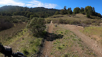
Photos of Tamarancho Mountain Bike
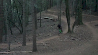
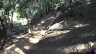
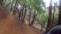
Videos of Tamarancho Mountain Bike
trail: Serpentine Trail
0:14 |
107 |
Nov 18, 2021
trail: Endor (Flow Trail)
0:08 |
356 |
Feb 12, 2018

trail: Endor (Flow Trail)
0:00 |
71 |
Jul 11, 2017

trail: Endor (Flow Trail)
0:54 |
944 |
Feb 15, 2016

trail: Endor (Flow Trail)
2:29 |
145 |
Sep 14, 2015
trail: Endor (Flow Trail)
3:32 |
835 |
Jun 10, 2015
trail: Wagon Wheel Trail
2:17 |
311 |
Feb 20, 2015
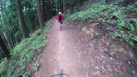
trail: Endor (Flow Trail)
0:32 |
422 |
Nov 10, 2014
Recent Trail Reports
| status | trail | date | condition | info | user |
|---|---|---|---|---|---|
| Caballo Rojo | Apr 15, 2026 @ 10:58pm (America/Los_Angeles) Apr 15, 2026 | Variable | Spindelatron | ||
| Wagon Wheel Trail | Apr 15, 2026 @ 10:56pm (America/Los_Angeles) Apr 15, 2026 | Variable | Spindelatron | ||
| Alchemist Trail | Apr 15, 2026 @ 10:56pm (America/Los_Angeles) Apr 15, 2026 | Variable | Spindelatron | ||
| Serpentine Trail | Apr 15, 2026 @ 10:56pm (America/Los_Angeles) Apr 15, 2026 | Variable | Spindelatron | ||
| Broken Dam Trail | Apr 15, 2026 @ 10:55pm (America/Los_Angeles) Apr 15, 2026 | Variable | Spindelatron | ||
| Goldman Trail | Apr 15, 2026 @ 10:55pm (America/Los_Angeles) Apr 15, 2026 | Variable | Spindelatron | ||
| B-17 Trail | Apr 15, 2026 @ 10:55pm (America/Los_Angeles) Apr 15, 2026 | Variable | Spindelatron | ||
| B-17 Extension | Apr 15, 2026 @ 10:55pm (America/Los_Angeles) Apr 15, 2026 | Variable | Spindelatron | ||
| Endor (Flow Trail) | Apr 15, 2026 @ 10:55pm (America/Los_Angeles) Apr 15, 2026 | Variable | Spindelatron | ||
| Saddlecut Trail | Apr 11, 2026 @ 10:26am (America/Los_Angeles) Apr 11, 2026 | Prevalent Mud | Spindelatron |
Activity Feed
| username | action | type | title | date |
|---|---|---|---|---|
| jamobado1 | wishlist | route | activity #97278851 | Jun 18, 2026 @ 3:21pm Jun 18, 2026 |
| rowdyrulez | wishlist | trail | activity #97261802 | Jun 18, 2026 @ 10:33am Jun 18, 2026 |
| JordanZIy1FQ | wishlist | trail | activity #97041023 | Jun 15, 2026 @ 7:50am Jun 15, 2026 |
| Alexandermasters43 | wishlist | trail | activity #96834589 | Jun 12, 2026 @ 4:22pm Jun 12, 2026 |
| AlecPMqAYT | wishlist | route | activity #96820498 | Jun 12, 2026 @ 12:09pm Jun 12, 2026 |
Recent Comments
| username | type | title | comment | date |
|---|---|---|---|---|
| trail | Great trail to practice cornering on! Less... | Apr 11, 2026 @ 9:37am Apr 11, 2026 | ||
| trail | Worth doing once. Top section was supremely... | Mar 1, 2026 @ 10:29am Mar 1, 2026 | ||
| trail | At the saddle, go right and up the fire road... | Jan 30, 2026 @ 8:08am Jan 30, 2026 | ||
| trail | Fun trail! Kind of a toned-down version of the... | Jan 19, 2026 @ 10:10pm Jan 19, 2026 | ||
| trail | Fun flow trail. The only downside is that its... | Aug 19, 2025 @ 5:40pm Aug 19, 2025 |
Nearby Areas
| name | distance | ||||
|---|---|---|---|---|---|
| White Hill Preserve | 4 | 0.6 km | |||
| Cascade Canyon Preserve | 1 | 1 | 0.7 km | ||
| Loma Alta Preserve | 3 | 1 | 1.4 km | ||
| Bald Hill | 1 | 2.1 km | |||
| San Domenico | 1 | 2 | 1 | 2.2 km |
Local Badges
-
Camp Tamarancho ESI1,118 awarded -

Completionist1 awarded
Bike & Skill Parks
| name | type | city | rating |
|---|---|---|---|
| Tamarancho Skill Park | skill park | Fairfax |
Local Products
Activity Type Stats
| activitytype | trails | distance | descent | descent distance | total vertical | rating | global rank | state rank | photos | reports | routes | ridelogs |
|---|---|---|---|---|---|---|---|---|---|---|---|---|
| Mountain Bike | 12 | 8 miles | 2,175 ft | 4 miles | 781 ft | #600 | #216 | 93 | 1,267 | 12 | 49,852 | |
| E-Bike | 13 | 8 miles | 2,175 ft | 4 miles | 781 ft | #2,921 | #910 | 1,209 | 2 | 5,978 | ||
| Hike | 11 | 8 miles | 1,926 ft | 3 miles | 781 ft | #1,216 | #594 | 1,167 | 2 | 1,351 | ||
| Trail Running | 11 | 8 miles | 1,926 ft | 3 miles | 781 ft | #8,446 | #2,963 | 1,167 | 2 | 1,343 |
Frequently Asked Questions About Tamarancho
▼
What are the highest rated mountain biking trails in Tamarancho?
The highest rated mountain biking trails in Tamarancho are:
- Wagon Wheel Trail (4.5/5)
- Endor (Flow Trail) (4.2/5)
- Serpentine Trail (4.2/5)
- Alchemist Trail (4.2/5)
- Caballo Rojo (4.2/5)
▼
What is the best time of the year to ride in Tamarancho?
Based on ride log data, the most popular months to ride in Tamarancho are:
- July (302 activities)
- October (259 activities)
- November (259 activities)
▼
Where can I park to ride in Tamarancho?
There are 1 parking locations listed in Tamarancho. The most popular parking spots are:
▼
What is the longest trail in Tamarancho?
The longest trail in Tamarancho is Broken Dam Trail at 1.9 miles. View all trails sorted by distance.
Activities
Trails
- By brenthillier
 NSMBA TRAILFORKS & contributors
 - Admins: A4B, A4B
- #6111 - 39,074 views
- tamarancho activity log | embed map of Tamarancho mountain bike trails | tamarancho mountain biking points of interest
Downloading of trail gps tracks in kml & gpx formats is enabled for Tamarancho.
You must login to download files.