close
-
Layers w
- Weather Layers
- Pro
- Pro
- Pro
- Pro
- Pro
- Pro
- More Layers
- Pro
- Pro
- Pro
- Pro
-
Upgrade to

3D
Trail Conditions
- Unknown
- Snow Groomed
- Snow Packed
- Snow Covered
- Snow Cover Partial
- Freeze/thaw Cycle
- Icy
- Prevalent Mud
- Wet
- Variable
- Ideal
- Dry
- Very Dry
Trail Flow (Ridden Direction)
Trailforks scans users ridelogs to determine the most popular direction each trail is ridden. A good flowing trail network will have most trails flowing in a single direction according to their intension.
The colour categories are based on what percentage of riders are riding a trail in its intended direction.
The colour categories are based on what percentage of riders are riding a trail in its intended direction.
- > 96%
- > 90%
- > 80%
- > 70%
- > 50%
- < 50%
- bi-directional trail
- no data
Trail Last Ridden
Trailforks scans ridelogs to determine the last time a trail was ridden.
- < 2 days
- < 1 week
- < 2 weeks
- < 1 month
- < 6 months
- > 6 months
Trail Ridden Direction
The intended direction a trail should be ridden.
- Downhill Only
- Downhill Primary
- Both Directions
- Uphill Primary
- Uphill Only
- One Direction
Contribute Details
Colors indicate trail is missing specified detail.
- Description
- Photos
- Description & Photos
- Videos
Trail Popularity ?
Trailforks scans ridelogs to determine which trails are ridden the most in the last 9 months.
Trails are compared with nearby trails in the same city region with a possible 25 colour shades.
Think of this as a heatmap, more rides = more kinetic energy = warmer colors.
- most popular
- popular
- less popular
- not popular
ATV/ORV/OHV Filter
Max Vehicle Width
inches
US Cell Coverage
Legend

Radar Time
Activity Recordings
Trailforks uses anonymized public activity data.
?
Activity Recordings
Trailforks uses anonymized public activity data.
?
Personal Heatmap
▶
Activity Types
all
/
none
▶
Options
2
Date range
month
–
Winter Trails
Warning
A routing network for winter maps does not exist. Selecting trails using the winter trails layer has been disabled.
Missing Trails
Most Popular
Least Popular
Trails are colored based on popularity. The more popular a trail is, the more red. Less popular trails trend towards green.
Jump Magnitude Heatmap
Heatmap of where riders jump on trails. Zoom in to see individual jumps, click circles to view jump details.
BC Backroad Status
![map legend]()
Service Road Atlas is a free to use, community-driven service for viewing and creating reports on the numerous back-country service roads around B.C. and Alberta.

Slope Aspect
Direction the slope faces
Trails Deemphasized
Trails are shown in grey.
Only show trails with no bike usage.
Suggested Layers
Based on selected activity type
Save the current map location and zoom level as your default home location whenever this page is loaded.
Save
No description for Taos has been added yet!
Login or register to submit one.
Activities Click to view
- Mountain Bike
81 trails
- E-Bike
15 trails
- Gravel Bike
0 trails
- Adaptive Bike
0 trails
- Horse
73 trails
- Hike
94 trails
- Trail Running
93 trails
- Dirtbike/Moto
20 trails
- Observed Trials
0 trails
- ATV/ORV/OHV
13 trails
- Snowmobile
1 trails
- Snowshoe
8 trails
- Downhill Ski
62 trails
- Backcountry Ski
1 trails
- Nordic Ski
7 trails
Region Details
- 7
- 18
- 42
- 13
Region Status
Open as of Jun 13, 2026Stats
- Avg Trail Rating
- Trails (view details)
- 128
- Trails Mountain Bike
- 81
- Trails E-Bike
- 15
- Trails Horse
- 73
- Trails Hike
- 94
- Trails Trail Running
- 93
- Trails Dirtbike/Moto
- 20
- Trails ATV/ORV/OHV
- 13
- Trails Snowmobile
- 1
- Trails Snowshoe
- 8
- Trails Downhill Ski
- 62
- Trails Backcountry Ski
- 1
- Trails Nordic Ski
- 7
- Total Distance
- 276 miles
- Total Descent
- 45,197 ft
- Total Vertical
- 5,742 ft
- Highest Trailhead
- 11,805 ft
- Reports
- 607
- Photos
- 192
- Ridden Counter
- 8,293
Sub Regions
-
Amole + Woodpile
- 2
- 16
- 6
-
Rio Fernando Watershed
- 3
- 14
- 5
-
Taos Valley Overlook Trails
- 8
- 3
Popular Taos Mountain Biking Trails
• 100 ★ 4.7 • 3,264 ft • 0 ft • 924 •
Popular blue difficulty alpine singletrack. This multi-use trail can be used both directions and has a hard overall physical rating with a 0 ft black diamond climb. On average it takes 6 minutes to complete this trail.
• 95 ★ 4.5 • 7 miles • 140 ft • 895 •
This track goes the opposite way I biked, so keep that in mind when you read this. Starting at near the summit of Sierra de Don Fernando, you descend on FR 164 for a bit before hopping on South Boundary. Once you're on SB, pop your bike...
• 100 ★ 4.5 • 2 miles • 348 ft • 878 •
This GPS track goes the opposite direction I was biking, but either way this section is pretty fun. I was headed uphill, and the track is pretty smooth and would be really fun as a downhill. I would imagine you can loop this as a...
• 100 ★ 4.6 • 3 miles • 6 ft • 665 •
First: THIS IS A MULTI-USE TRAIL. Watch for hikers and horses, yield the trail, and please be polite when passing. This is also the exclamation point at the end of the South Boundary Trail. It's loose at times, rocky, and pretty steep...
• 95 ★ 4.8 • 6 miles • 436 ft • 617 •
The SBT (Trail 164) is typically ridden from east to west, starting at either the trailhead near Angel Fire, or the Garcia Park trailhead near Valle Escondido. Typically these start points are accessed via a shuttle. Riding east to west...
• 90 ★ 4.0 • 10 miles • 1,103 ft • 257 •
Popular green difficulty family friendly singletrack. This multi-use trail can be used both directions and has a moderate overall physical rating with a 1,103 ft green climb. Trail visibility is always easy to follow. On average it takes 1 hour9 minutes to complete this trail.
• 100 ★ 0.0 • 807 ft • 0 ft • 252 •
Popular blue difficulty alpine singletrack. This multi-use trail can be used both directions and has a hard overall physical rating with a 0 ft black diamond climb.
Taos Mountain Bike Routes
South Boundary - Lower Shuttle Featured
★ 5.0 • 21 miles • 2,034 ft • 7 • Shuttled •
This is the classic Shuttle Start from FR76 on the Angel Fire side and ride up and over Osha Pass, down...
Rift Valley Loop Featured
★ 3.0 • 12 miles • 927 ft • 3 • Loop •
trail at the Taos Valley Overlook trail network, beginning at the trailhead located at the end of County...
Ojelno! (Ojitos to El Nogal) Featured
★ 5.0 • 11 miles • 1,967 ft • 2 • Loop •
Ride up and down the , starting at the parking lot.
★ 5.0 • 20 miles • 1,147 ft • 9 • Shuttled •
An alternate shuttle route for the South Boundary Trail starts 600' higher on FR153 off FR76 and avoids...
★ 5.0 • 47 miles • 5,355 ft • 5 • Loop •
This is a way to ride the entire route without a shuttle, and avoiding riding highway 64.
Photos of Taos Mountain Bike
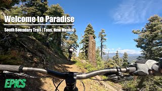
Videos of Taos Mountain Bike


Recent Trail Reports
National Scenic Trails & Official Routes
-
Continental Divide Trail
- Mountain Bike
- Hike
- Trail Running

Activity Feed
| username | action | type | title | date |
|---|---|---|---|---|
| IYqPKXSQ | wishlist | trail | activity #97120235 | Jun 16, 2026 @ 10:14am 2 days |
| jkenney | wishlist | route | activity #97103868 | Jun 16, 2026 @ 6:03am 2 days |
| jkenney | wishlist | trail | activity #97103813 | Jun 16, 2026 @ 6:02am 2 days |
| ehservice | checkin | route | activity #97072252 | Jun 15, 2026 @ 4:20pm 3 days |
| ehservice | wishlist | route | activity #97072187 | Jun 15, 2026 @ 4:19pm 3 days |
Recent Comments
| username | type | title | comment | date |
|---|---|---|---|---|
| trail | Deep moto ruts and quite loose in sections.... | Jun 12, 2026 @ 8:04pm Jun 12, 2026 | ||
| trail | No trees down currently! One of the best... | Oct 18, 2025 @ 1:19pm Oct 18, 2025 | ||
| trail | Way too many downed trees, plus the creek... | Sep 27, 2025 @ 9:03pm Sep 27, 2025 | ||
| trail | I’m | Sep 22, 2025 @ 10:28am Sep 22, 2025 | ||
| trail | I know this is way old, but this may help... | Aug 30, 2025 @ 5:16pm Aug 30, 2025 |
Local Badges
-

Completionist0 awarded -

Big Ride 30k983 awarded -

Epic Ride 50k203 awarded -

Top 10 Trails5 awarded -

Descent 100k Badge1 awarded -

10 Black Trails13 awarded
Bike & Skill Parks
| name | type | city | rating |
|---|---|---|---|
| Sipapu Ski & Summer Resort | bike park | Taos |
Local Products
Activity Type Stats
| activitytype | trails | distance | descent | descent distance | total vertical | rating | global rank | state rank | photos | reports | routes | ridelogs |
|---|---|---|---|---|---|---|---|---|---|---|---|---|
| Mountain Bike | 81 | 257 miles | 36,690 ft | 120 miles | 5,728 ft | #1,039 | #408 | 178 | 604 | 27 | 5,597 | |
| E-Bike | 15 | 86 miles | 10,787 ft | 42 miles | 4,308 ft | #2,262 | #963 | 3 | 337 | 1 | 158 | |
| Horse | 73 | 240 miles | 34,117 ft | 115 miles | 5,728 ft | #98 | #366 | 223 | 5 | |||
| Hike | 94 | 268 miles | 37,549 ft | 122 miles | 5,741 ft | #391 | #181 | 2 | 606 | 8 | 970 | |
| Trail Running | 93 | 266 miles | 37,533 ft | 122 miles | 5,741 ft | #541 | #207 | 4 | 606 | 8 | 483 | |
| Dirtbike/Moto | 20 | 82 miles | 8,963 ft | 33 miles | 4,094 ft | #522 | #172 | 128 | 13 | |||
| ATV/ORV/OHV | 13 | 52 miles | 5,869 ft | 26 miles | 3,652 ft | #434 | #140 | 128 | 7 | |||
| Snowmobile | 1 | 1 mile | 164 ft | 3,061 ft | 151 ft | #247 | #119 | |||||
| Snowshoe | 8 | 16 miles | 2,142 ft | 7 miles | 2,720 ft | #806 | #370 | 11 | 28 | |||
| Downhill Ski | 62 | 9 miles | 7,651 ft | 8 miles | 1,056 ft | #402 | #158 | 385 | ||||
| Backcountry Ski | 1 | #551 | #164 | 112 | ||||||||
| Nordic Ski | 7 | 16 miles | 2,142 ft | 7 miles | 2,720 ft | #875 | #350 | 11 | 58 |
Frequently Asked Questions About Taos
▼
What are the best places to ride in Taos?
Taos has 4 areas to explore for mountain biking. The top rated areas are:
▼
What are the highest rated mountain biking trails in Taos?
The highest rated mountain biking trails in Taos are:
- South Boundary Trail - Osha Pass to Garcia Park (4.5/5)
- South Boundary Trail - El Nogal Section (4.4/5)
- South Boundary Trail - Don Fernando to Ojitos (4.3/5)
- South Boundary Trail #164: East Addendum (4.2/5)
- South Boundary Trail - Garcia Park to Don Fernando (4.2/5)
▼
What is the best time of the year to ride in Taos?
Based on ride log data, the most popular months to ride in Taos are:
- October (102 activities)
- September (91 activities)
- July (87 activities)
▼
Where can I park to ride in Taos?
There are 17 parking locations listed in Taos. The most popular parking spots are: View all parking and trailhead locations on the map to plan your visit.
Activities
Trails
Points of Interest
- Petaca Point Viewpoint
- Water Tank Sight
- Pilar Campground Camping
- Rio Bravo Campround Camping
- Arroyo Hondo Campground Camping
- Lone Juniper Recreation Site Camping
- Taos Junction Campground Camping
- Rio Pueblo Campground Camping
- Las Petacas Campground Camping
- La Sombra Campground Camping
- Truchas Peak (13,100 ft)
- West Truchas Peak (13,045 ft)
- North Truchas Peak (12,979 ft)
- By brenthillier
 NSMBA TRAILFORKS & contributors
 - Admins: TMBA, ECTA, ECTA
- #4286 - 21,032 views
- taos activity log | embed map of Taos mountain bike trails | taos mountain biking points of interest
Downloading of trail gps tracks in kml & gpx formats is enabled for Taos.
You must login to download files.