close
-
Layers w
- Weather Layers
- Pro
- Pro
- Pro
- Pro
- Pro
- Pro
- More Layers
- Pro
- Pro
- Pro
- Pro
-
Upgrade to

3D
Trail Conditions
- Unknown
- Snow Groomed
- Snow Packed
- Snow Covered
- Snow Cover Partial
- Freeze/thaw Cycle
- Icy
- Prevalent Mud
- Wet
- Variable
- Ideal
- Dry
- Very Dry
Trail Flow (Ridden Direction)
Trailforks scans users ridelogs to determine the most popular direction each trail is ridden. A good flowing trail network will have most trails flowing in a single direction according to their intension.
The colour categories are based on what percentage of riders are riding a trail in its intended direction.
The colour categories are based on what percentage of riders are riding a trail in its intended direction.
- > 96%
- > 90%
- > 80%
- > 70%
- > 50%
- < 50%
- bi-directional trail
- no data
Trail Last Ridden
Trailforks scans ridelogs to determine the last time a trail was ridden.
- < 2 days
- < 1 week
- < 2 weeks
- < 1 month
- < 6 months
- > 6 months
Trail Ridden Direction
The intended direction a trail should be ridden.
- Downhill Only
- Downhill Primary
- Both Directions
- Uphill Primary
- Uphill Only
- One Direction
Contribute Details
Colors indicate trail is missing specified detail.
- Description
- Photos
- Description & Photos
- Videos
Trail Popularity ?
Trailforks scans ridelogs to determine which trails are ridden the most in the last 9 months.
Trails are compared with nearby trails in the same city region with a possible 25 colour shades.
Think of this as a heatmap, more rides = more kinetic energy = warmer colors.
- most popular
- popular
- less popular
- not popular
ATV/ORV/OHV Filter
Max Vehicle Width
inches
US Cell Coverage
Legend

Radar Time
Activity Recordings
Trailforks uses anonymized public activity data.
?
Activity Recordings
Trailforks uses anonymized public activity data.
?
Personal Heatmap
▶
Activity Types
all
/
none
▶
Options
2
Date range
month
–
Winter Trails
Warning
A routing network for winter maps does not exist. Selecting trails using the winter trails layer has been disabled.
Missing Trails
Most Popular
Least Popular
Trails are colored based on popularity. The more popular a trail is, the more red. Less popular trails trend towards green.
Jump Magnitude Heatmap
Heatmap of where riders jump on trails. Zoom in to see individual jumps, click circles to view jump details.
BC Backroad Status
![map legend]()
Service Road Atlas is a free to use, community-driven service for viewing and creating reports on the numerous back-country service roads around B.C. and Alberta.

Slope Aspect
Direction the slope faces
Trails Deemphasized
Trails are shown in grey.
Only show trails with no bike usage.
Suggested Layers
Based on selected activity type
Save the current map location and zoom level as your default home location whenever this page is loaded.
Save
No description for Taree has been added yet!
Login or register to submit one.
Activities Click to view
- Mountain Bike
205 trails
- E-Bike
166 trails
- Gravel Bike
0 trails
- Adaptive Bike
0 trails
- Winter Fat Bike
0 trails
- Horse
13 trails
- Hike
154 trails
- Trail Running
155 trails
- Dirtbike/Moto
41 trails
Region Details
- 30
- 7
- 68
- 57
- 16
- 1
Region Status
Caution as of Apr 30, 2026Stats
- Avg Trail Rating
- Global Ranking
- #579
- State Ranking
- #31
- Trails (view details)
- 180
- Trails Mountain Bike
- 205
- Trails E-Bike
- 166
- Trails Horse
- 13
- Trails Hike
- 154
- Trails Trail Running
- 155
- Trails Dirtbike/Moto
- 41
- Trails ATV/ORV/OHV
- 1
- Total Distance
- 101 miles
- Total Descent
- 10,359 ft
- Total Vertical
- 787 ft
- Highest Trailhead
- 804 ft
- Reports
- 3,593
- Photos
- 324
- Ridden Counter
- 34,869
Sub Regions
-
Hallidays Point
- 1
- 4
-
Kiwarrak State Forest
- 5
- 38
- 50
- 16
- 1
-
Old Bar
- 24
Popular Taree Mountain Biking Trails
• 100 ★ 3.2 • 2,808 ft • 36 ft • 735 •
Popular green difficulty singletrack. This mountain bike primary trail. On average it takes 3 minutes to complete this trail.
• 100 ★ 3.5 • 892 ft • 9 ft • 696 •
Popular blue difficulty singletrack. This mountain bike primary trail. On average it takes 1 minutes to complete this trail.
• 95 ★ 4.6 • 2,582 ft • 6 ft • 681 •
Starting off a old , trail heads hill over 4 progressively larger drops, all with B lines, to the top of a creek gully. Steep wooden roll into creek or walking B line to right. Trail then winds through creek to optional log ride....
• 100 ★ 2.0 • 2,290 ft • 30 ft • 615 •
Popular green difficulty singletrack. This mountain bike primary trail can be used downhill primary and has a easy overall physical rating with a 30 ft green climb. On average it takes 3 minutes to complete this trail.
• 100 ★ 4.0 • 1,900 ft • 41 ft • 554 •
Popular green difficulty singletrack. This mountain bike primary trail. On average it takes 2 minutes to complete this trail.
• 95 ★ 3.0 • 1,171 ft • 26 ft • 549 •
Popular blue difficulty singletrack. This mountain bike primary trail. On average it takes 1 minutes to complete this trail.
• 90 ★ 3.7 • 4,311 ft • 26 ft • 538 •
Popular blue difficulty singletrack. This mountain bike primary trail can be used both directions and has a moderate overall physical rating with a 26 ft green climb. Trail visibility is always easy to follow. On average it takes 6 minutes to complete this trail.
• 100 ★ 3.8 • 984 ft • 0 ft • 528 •
Popular black diamond difficulty singletrack. This mountain bike primary trail can be used downhill primary and has a easy overall physical rating with a 0 ft green climb. On average it takes 1 minutes to complete this trail.
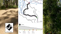
Taree Mountain Bike Routes
★ 4.0 • 8 miles • 550 ft • 12 • Loop •
This is a reasonable length route that covers a good cross-section of old and newer trails at Kiawarrak.
★ 2.4 • 11 miles • 1,418 ft • 49 • Out & Back •
Welcome to The Big Fella! I designed this route to take in the majority of the technical trails that the...
10 miles • 1,007 ft • 13 • Loop •
The loop that will give you a bit of everything that Kiwarrak has to offer. Includes plenty of XC with...
6 miles • 454 ft • 20 • Loop • Race •
Welcome to the 2017 PBM Hardrock 6hr race loop, in the Kiwarrak Mountain Bike Park, Taree. This year's...
4 miles • 329 ft • 8 • Loop • Race •
Manning Great Lakes Tip riders are proud to announce we will be hosting the PBM HARDROCK 6hr MTB race on...
• 14 miles • 1,141 ft • 23 •
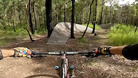
Photos of Taree Mountain Bike
Videos of Taree Mountain Bike
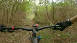
trail: 3 X 3
4:25 |
240 |
Jun 5, 2022
trail: Up River
6:58 |
196 |
Apr 6, 2022

trail: Trampoline
4:36 |
144 |
Mar 26, 2022

trail: Olivers Trail
3:56 |
154 |
Mar 24, 2022
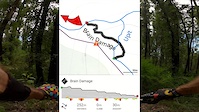
trail: Brain Damage
5:46 |
230 |
Mar 24, 2022

trail: 3 X 3
4:25 |
528 |
Mar 24, 2022
trail: Green Hils Mtb
5:22 |
124 |
Aug 6, 2024 , Taree
trail: Trampoline
5:31 |
157 |
Aug 6, 2024 , Taree
Recent Trail Reports
| status | trail | date | condition | info | user |
|---|---|---|---|---|---|
| Yowie | May 1, 2026 @ 3:15pm (Australia/Sydney) Apr 30, 2026 | Variable | Snailracing MGLTR | ||
| Yahoo | May 1, 2026 @ 3:15pm (Australia/Sydney) Apr 30, 2026 | Variable | Snailracing MGLTR | ||
| Willy Wally Gully Extension | May 1, 2026 @ 3:15pm (Australia/Sydney) Apr 30, 2026 | Variable | Snailracing MGLTR | ||
| Willy Wally Gully | May 1, 2026 @ 3:15pm (Australia/Sydney) Apr 30, 2026 | Variable | Snailracing MGLTR | ||
| Widow Maker | May 1, 2026 @ 3:15pm (Australia/Sydney) Apr 30, 2026 | Variable | Snailracing MGLTR | ||
| Whoa Boy | May 1, 2026 @ 3:15pm (Australia/Sydney) Apr 30, 2026 | Variable | Snailracing MGLTR | ||
| Whiplash | May 1, 2026 @ 3:15pm (Australia/Sydney) Apr 30, 2026 | Variable | Snailracing MGLTR | ||
| What Eva | May 1, 2026 @ 3:15pm (Australia/Sydney) Apr 30, 2026 | Variable | Snailracing MGLTR | ||
| Warm up | May 1, 2026 @ 3:15pm (Australia/Sydney) Apr 30, 2026 | Variable | Snailracing MGLTR | ||
| Warm Up | May 1, 2026 @ 3:15pm (Australia/Sydney) Apr 30, 2026 | Variable | Snailracing MGLTR |
Activity Feed
| username | action | type | title | date |
|---|---|---|---|---|
| soutmlc | add | karma | activity #95774833 | May 29, 2026 @ 7:13am May 29, 2026 |
| JoshEasty | wishlist | region | activity #94296337 | May 8, 2026 @ 6:22pm May 8, 2026 |
| Snailracing | add | report | activity #93757006 and 127 more | Apr 30, 2026 @ 10:14pm Apr 30, 2026 |
| Snailracing | add | trail | activity #93756528 and 1 more | Apr 30, 2026 @ 9:49pm Apr 30, 2026 |
| CoreyGarratley | wishlist | region | activity #93243664 | Apr 23, 2026 @ 3:36pm Apr 23, 2026 |
Recent Comments
| username | type | title | comment | date |
|---|---|---|---|---|
| trail | this trail needs a lot of maintenance. large... | Feb 23, 2026 @ 6:36pm Feb 23, 2026 | ||
| trail | This trail has potential, but it needs a lot... | Feb 20, 2026 @ 9:02pm Feb 20, 2026 | ||
| trail | Just easy fun! | Apr 7, 2025 @ 2:44am Apr 7, 2025 | ||
| trail | Fun! | Apr 7, 2025 @ 2:43am Apr 7, 2025 | ||
| trail | Lots of debris, but the view at the lake is... | Apr 7, 2025 @ 2:43am Apr 7, 2025 |
Local Badges
-

Top 10 Trails24 awarded -

Descent 100k Badge3 awarded -

Big Ride 30k735 awarded -

Epic Ride 50k317 awarded -

Descent 10k Badge34 awarded -

Completionist0 awarded
Activity Type Stats
| activitytype | trails | distance | descent | descent distance | total vertical | rating | global rank | state rank | photos | reports | routes | ridelogs |
|---|---|---|---|---|---|---|---|---|---|---|---|---|
| Mountain Bike | 205 | 100 miles | 10,315 ft | 42 miles | 787 ft | #579 | #31 | 324 | 3,591 | 7 | 12,967 | |
| E-Bike | 166 | 79 miles | 8,586 ft | 34 miles | 787 ft | #1,083 | #67 | 3,578 | 2 | 1,045 | ||
| Horse | 13 | 31 miles | 2,306 ft | 12 miles | 787 ft | #858 | #44 | 807 | 4 | |||
| Hike | 154 | 81 miles | 6,532 ft | 31 miles | 787 ft | #2,194 | #66 | 3,542 | 262 | |||
| Trail Running | 155 | 81 miles | 6,539 ft | 31 miles | 787 ft | #1,693 | #48 | 3,545 | 88 | |||
| Dirtbike/Moto | 41 | 27 miles | 2,169 ft | 10 miles | 787 ft | #431 | #19 | 807 | 15 | |||
| ATV/ORV/OHV | 1 | 948 ft | 102 ft | 676 |
Frequently Asked Questions About Taree
▼
What are the best places to ride in Taree?
Taree has 3 areas to explore for mountain biking. The top rated areas are:
▼
What are the highest rated mountain biking trails in Taree?
The highest rated mountain biking trails in Taree are:
- Trampoline (4.5/5)
- Brain Damage (4.3/5)
- 3 X 3 (4.3/5)
- Up River (4.3/5)
- Stairway To Heaven / Highway To Hell (4.2/5)
▼
What is the best time of the year to ride in Taree?
Based on ride log data, the most popular months to ride in Taree are:
- September (150 activities)
- October (145 activities)
- August (136 activities)
▼
Where can I park to ride in Taree?
There are 4 parking locations listed in Taree. The most popular parking spots are: View all parking and trailhead locations on the map to plan your visit.
Activities
Trails
- By brenthillier
 NSMBA TRAILFORKS & contributors
 - Admins: stuartrichardson, MGLTR
- #7699 - 12,126 views
- taree activity log | embed map of Taree mountain bike trails | taree mountain biking points of interest
Downloading of trail gps tracks in kml & gpx formats is enabled for Taree.
You must login to download files.