close
-
Layers w
- Weather Layers
- Pro
- Pro
- Pro
- Pro
- Pro
- Pro
- More Layers
- Pro
- Pro
- Pro
- Pro
-
Upgrade to

3D
Trail Conditions
- Unknown
- Snow Groomed
- Snow Packed
- Snow Covered
- Snow Cover Partial
- Freeze/thaw Cycle
- Icy
- Prevalent Mud
- Wet
- Variable
- Ideal
- Dry
- Very Dry
Trail Flow (Ridden Direction)
Trailforks scans users ridelogs to determine the most popular direction each trail is ridden. A good flowing trail network will have most trails flowing in a single direction according to their intension.
The colour categories are based on what percentage of riders are riding a trail in its intended direction.
The colour categories are based on what percentage of riders are riding a trail in its intended direction.
- > 96%
- > 90%
- > 80%
- > 70%
- > 50%
- < 50%
- bi-directional trail
- no data
Trail Last Ridden
Trailforks scans ridelogs to determine the last time a trail was ridden.
- < 2 days
- < 1 week
- < 2 weeks
- < 1 month
- < 6 months
- > 6 months
Trail Ridden Direction
The intended direction a trail should be ridden.
- Downhill Only
- Downhill Primary
- Both Directions
- Uphill Primary
- Uphill Only
- One Direction
Contribute Details
Colors indicate trail is missing specified detail.
- Description
- Photos
- Description & Photos
- Videos
Trail Popularity ?
Trailforks scans ridelogs to determine which trails are ridden the most in the last 9 months.
Trails are compared with nearby trails in the same city region with a possible 25 colour shades.
Think of this as a heatmap, more rides = more kinetic energy = warmer colors.
- most popular
- popular
- less popular
- not popular
ATV/ORV/OHV Filter
Max Vehicle Width
inches
US Cell Coverage
Legend

Radar Time
Activity Recordings
Trailforks uses anonymized public activity data.
?
Activity Recordings
Trailforks uses anonymized public activity data.
?
Personal Heatmap
▶
Activity Types
all
/
none
▶
Options
2
Date range
month
–
Winter Trails
Warning
A routing network for winter maps does not exist. Selecting trails using the winter trails layer has been disabled.
Missing Trails
Most Popular
Least Popular
Trails are colored based on popularity. The more popular a trail is, the more red. Less popular trails trend towards green.
Jump Magnitude Heatmap
Heatmap of where riders jump on trails. Zoom in to see individual jumps, click circles to view jump details.
BC Backroad Status
![map legend]()
Service Road Atlas is a free to use, community-driven service for viewing and creating reports on the numerous back-country service roads around B.C. and Alberta.

Slope Aspect
Direction the slope faces
Trails Deemphasized
Trails are shown in grey.
Only show trails with no bike usage.
Suggested Layers
Based on selected activity type
Save the current map location and zoom level as your default home location whenever this page is loaded.
Save
No description for Tarvisio has been added yet!
Login or register to submit one.
This region uses the Uk/Euro style trail grading system.
Activities Click to view
- Mountain Bike
57 trails
- E-Bike
38 trails
- Gravel Bike
0 trails
- Adaptive Bike
0 trails
- Winter Fat Bike
0 trails
- Hike
53 trails
- Trail Running
51 trails
Region Details
- 19
- 4
- 2
- 12
- 6
- 2
Region Status
Caution as of Jun 4, 2026Stats
- Avg Trail Rating
- Trails (view details)
- 54
- Trails Mountain Bike
- 57
- Trails E-Bike
- 38
- Trails Hike
- 53
- Trails Trail Running
- 51
- Trails Dirtbike/Moto
- 1
- Trails ATV/ORV/OHV
- 1
- Trails Snowshoe
- 1
- Trails Backcountry Ski
- 3
- Total Distance
- 117 miles
- Total Descent
- 35,461 ft
- Total Vertical
- 4,478 ft
- Highest Trailhead
- 6,325 ft
- Reports
- 241
- Photos
- 276
- Ridden Counter
- 3,425
Sub Regions
-
Camporosso - Ugovizza
- 5
- 1
-
Tarvisio - Val Romana
- 2
- 1
- 4
- 2
- 1
-
Valbruna
- 1
- 1
- 3
- 3
- 1
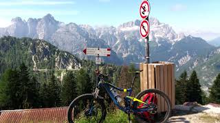
Popular Tarvisio Mountain Biking Trails
• 100 ★ 0.0 • 1 mile • 348 ft • 312 •
From Alpe Adria Cycle Path by taking this other one you climb untile the first Lake of Fusine
• 100 ★ 0.0 • 7 miles • 493 ft • 274 •
Cycle Path that links Tarvisio to Rateče villages
• 85 ★ 4.5 • 5 miles • 254 ft • 217 •
The first third starts on the alpine medow beside the Acomizza hut which is part of the "Alpe Adria trail." The moderate descend will take you trough a scenic forest where you encounter some switchbacks (at the end of this section...
• 90 ★ 2.0 • 19 miles • 817 ft • 167 •
Ripartiamo da Tarvisio continuando a pedalare in leggera salita sempre sul vecchio tracciato ferroviario trasformato in pista ciclabile asfaltata. Usciti dalla cittadina attraversiamo un altro tratto della millenaria Foresta di Tarvisio...
• 75 ★ 1.8 • 3 miles • 180 ft • 79 •
Versatile trail with a bit steeper rooted upper section (can skip this section on gravel road if necessary), some dirt/gravel road in the middle and some easy meadow path at the bottom. It is a hiking path. Respect the hikers!
• 80 ★ 5.0 • 1 mile • 77 ft • 62 •
A short (S1/S2) trail descending from the east peak of Monte Nebria. It's a flowy trail, passing through a deciduous forest, with some nice switchbacks. In autumn the trail may be difficult to be found, because of the many leaves on ground.
• 55 ★ 4.6 • 1 mile • 0 ft • 60 •
Flowy steep alpine singletrack with a bit of exposure and some switchbacks on the lower third. The trail consist mostly of rock and marble sized limestone.
• 60 ★ 4.0 • 2 miles • 39 ft • 49 •
Alternative route to the , descending from Malga Acomizza; it ends in the Bartolo valley. The narrow singletrail proceeds from a rooty upper section to a more gravel pronounced lower part (both sections have S2 difficulty). As some...
Tarvisio Mountain Bike Routes
15 miles • 5,604 ft • 3 • Loop •
Lonely and sometimes scenic uphill. Both descents are awesome.
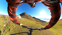
Photos of Tarvisio Mountain Bike
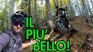
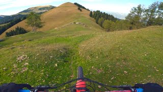
Videos of Tarvisio Mountain Bike
trail: Arlecchino Trail
3:43 |
355 |
Nov 13, 2020
trail: Arlecchino Trail
15:00 |
114 |
Nov 2, 2025 , Tarvisio
trail: Arlecchino Trail
19:19 |
84 |
Sep 22, 2025 , Tarvisio
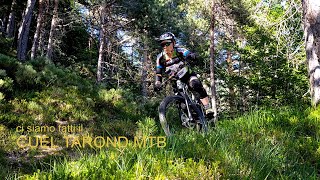
trail: Sella Tarondo
9:50 |
75 |
Mar 22, 2025 , Tarvisio
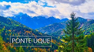
trail: Ponte uque - park
5:13 |
64 |
Nov 8, 2024 , Tarvisio
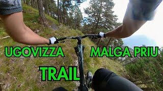
trail: DH Ugovizza Malga Priu T2
11:03 |
115 |
Oct 23, 2024 , Tarvisio
trail: Prasnig trail
10:01 |
92 |
Oct 10, 2024 , Tarvisio

trail: Riofreddo Trail
10:01 |
178 |
Oct 10, 2024 , Tarvisio
Recent Trail Reports
| status | trail | date | condition | info | user |
|---|---|---|---|---|---|
| Monte Nebria DH2 | Jun 4, 2026 @ 6:42pm (Europe/Rome) Jun 4, 2026 | Dry | AndreafLvVg | ||
| Arlecchino Trail | Jun 2, 2026 @ 7:48pm (Europe/Rome) Jun 2, 2026 | Ideal | Jackursella | ||
| Rio Rauno Trail | Jun 2, 2026 @ 4:58pm (Europe/Rome) Jun 2, 2026 | Ideal | Cesco92 | ||
| Sentiero 612 | Jun 1, 2026 @ 8:27am (Europe/Rome) May 31, 2026 | Dry | ves | ||
| Ponte uque - park | May 3, 2026 @ 12:55pm (Europe/Rome) May 3, 2026 | Ideal | Articolo18 | ||
| Bistrizza Trail | May 3, 2026 @ 12:55pm (Europe/Rome) May 3, 2026 | Ideal | Articolo18 | ||
| Bistrizza Trail Access | May 3, 2026 @ 12:55pm (Europe/Rome) May 3, 2026 | Ideal | Articolo18 | ||
| Climb to Malga Rauna | Apr 21, 2026 @ 6:37pm (Europe/Rome) Apr 21, 2026 | Snow Cover Partial | Lambdo | ||
| RaunaNebria DH 1 | Apr 21, 2026 @ 6:31pm (Europe/Rome) Apr 21, 2026 | Snow Cover Partial | Lambdo | ||
| Cycle Path Tarvisio - Rateče | Apr 12, 2026 @ 7:50am (Europe/Ljubljana) Apr 11, 2026 | Ideal | chriguc |
Activity Feed
| username | action | type | title | date |
|---|---|---|---|---|
| DanieleyW51lL | ridden | trail | activity #97166569 | Jun 17, 2026 @ 12:23am Jun 17, 2026 |
| AndreafLvVg | add | report | activity #96234636 | Jun 4, 2026 @ 9:42am Jun 4, 2026 |
| Jackursella | add | report | activity #96095835 | Jun 2, 2026 @ 10:48am Jun 2, 2026 |
| Cesco92 | add | report | activity #96084439 | Jun 2, 2026 @ 7:58am Jun 2, 2026 |
| ves | add | photo | activity #96002060 and 3 more | Jun 1, 2026 @ 12:08am Jun 1, 2026 |
Recent Comments
| username | type | title | comment | date |
|---|---|---|---|---|
| report | Snow is gone , bottom part is surfing leafs,... | Apr 25, 2026 @ 12:26pm Apr 25, 2026 | ||
| trail | I don't live in the alps but this trail is... | Jul 20, 2024 @ 7:37am Jul 20, 2024 | ||
| trail | This is super steep!! | Jul 19, 2024 @ 2:19am Jul 19, 2024 | ||
| trail | Nessun problema, grazie mille ☺️ | Apr 10, 2024 @ 4:37am Apr 10, 2024 | ||
| trail | Scusa Marco, ho fatto confusione. Ora l'ho... | Apr 9, 2024 @ 11:35am Apr 9, 2024 |
Local Badges
-

Epic Ride Climb 2k340 awarded -

Climbing 10k Badge37 awarded -

Climbing 100k Badge1 awarded -

Epic Ride Descent 2k340 awarded -

Descent 10k Badge38 awarded -

Descent 100k Badge1 awarded
Bike & Skill Parks
| name | type | city | rating |
|---|---|---|---|
| Ugovizza Pump Track | skill park | Tarvisio |
Activity Type Stats
| activitytype | trails | distance | descent | descent distance | total vertical | rating | global rank | state rank | photos | reports | routes | ridelogs |
|---|---|---|---|---|---|---|---|---|---|---|---|---|
| Mountain Bike | 57 | 112 miles | 34,790 ft | 51 miles | 3,980 ft | #1,970 | #79 | 268 | 239 | 3 | 3,315 | |
| E-Bike | 38 | 84 miles | 17,037 ft | 32 miles | 3,980 ft | #1,562 | #170 | 3 | 154 | 1 | 536 | |
| Hike | 53 | 104 miles | 32,382 ft | 47 miles | 3,980 ft | #1,891 | #66 | 5 | 238 | 1 | 964 | |
| Trail Running | 51 | 102 miles | 30,472 ft | 46 miles | 3,980 ft | #1,541 | #50 | 237 | 2 | 77 | ||
| Dirtbike/Moto | 1 | 3 | ||||||||||
| ATV/ORV/OHV | 1 | 3 | ||||||||||
| Snowshoe | 1 | 1 mile | 1,339 ft | 1 mile | 1,332 ft | 2 | 13 | |||||
| Backcountry Ski | 3 | 7 miles | 2,008 ft | 2 miles | 3,376 ft | 2 | 705 |
Frequently Asked Questions About Tarvisio
▼
What are the best places to ride in Tarvisio?
Tarvisio has 3 areas to explore for mountain biking. The top rated areas are:
▼
What are the highest rated mountain biking trails in Tarvisio?
The highest rated mountain biking trails in Tarvisio are:
- Monte Nebria DH 1 (4.5/5)
- Arlecchino Trail (4.3/5)
- DH Ugovizza Malga Priu T2 (4.3/5)
- Rio Rauno Trail (4.2/5)
- Cervo Trail (4.1/5)
▼
What is the best time of the year to ride in Tarvisio?
Based on ride log data, the most popular months to ride in Tarvisio are:
- August (34 activities)
- July (31 activities)
- June (23 activities)
▼
Where can I park to ride in Tarvisio?
Activities
Trails
- By maxmisdaris
 MGNR & contributors
 - Admins: maxmisdaris
- #17743 - 10,879 views
- tarvisio activity log | embed map of Tarvisio mountain bike trails | tarvisio mountain biking points of interest
Downloading of trail gps tracks in kml & gpx formats is enabled for Tarvisio.
You must login to download files.