close
-
Layers w
- Weather Layers
- Pro
- Pro
- Pro
- Pro
- Pro
- Pro
- More Layers
- Pro
- Pro
- Pro
- Pro
-
Upgrade to

3D
Trail Conditions
- Unknown
- Snow Groomed
- Snow Packed
- Snow Covered
- Snow Cover Partial
- Freeze/thaw Cycle
- Icy
- Prevalent Mud
- Wet
- Variable
- Ideal
- Dry
- Very Dry
Trail Flow (Ridden Direction)
Trailforks scans users ridelogs to determine the most popular direction each trail is ridden. A good flowing trail network will have most trails flowing in a single direction according to their intension.
The colour categories are based on what percentage of riders are riding a trail in its intended direction.
The colour categories are based on what percentage of riders are riding a trail in its intended direction.
- > 96%
- > 90%
- > 80%
- > 70%
- > 50%
- < 50%
- bi-directional trail
- no data
Trail Last Ridden
Trailforks scans ridelogs to determine the last time a trail was ridden.
- < 2 days
- < 1 week
- < 2 weeks
- < 1 month
- < 6 months
- > 6 months
Trail Ridden Direction
The intended direction a trail should be ridden.
- Downhill Only
- Downhill Primary
- Both Directions
- Uphill Primary
- Uphill Only
- One Direction
Contribute Details
Colors indicate trail is missing specified detail.
- Description
- Photos
- Description & Photos
- Videos
Trail Popularity ?
Trailforks scans ridelogs to determine which trails are ridden the most in the last 9 months.
Trails are compared with nearby trails in the same city region with a possible 25 colour shades.
Think of this as a heatmap, more rides = more kinetic energy = warmer colors.
- most popular
- popular
- less popular
- not popular
ATV/ORV/OHV Filter
Max Vehicle Width
inches
US Cell Coverage
Legend

Radar Time
Activity Recordings
Trailforks uses anonymized public activity data.
?
Activity Recordings
Trailforks uses anonymized public activity data.
?
Personal Heatmap
▶
Activity Types
all
/
none
▶
Options
2
Date range
month
–
Winter Trails
Warning
A routing network for winter maps does not exist. Selecting trails using the winter trails layer has been disabled.
Missing Trails
Most Popular
Least Popular
Trails are colored based on popularity. The more popular a trail is, the more red. Less popular trails trend towards green.
Jump Magnitude Heatmap
Heatmap of where riders jump on trails. Zoom in to see individual jumps, click circles to view jump details.
BC Backroad Status
![map legend]()
Service Road Atlas is a free to use, community-driven service for viewing and creating reports on the numerous back-country service roads around B.C. and Alberta.

Slope Aspect
Direction the slope faces
Trails Deemphasized
Trails are shown in grey.
Only show trails with no bike usage.
Suggested Layers
Based on selected activity type
Save the current map location and zoom level as your default home location whenever this page is loaded.
Save
No description for Te Anau has been added yet!
Login or register to submit one.
Activities Click to view
- Mountain Bike
32 trails
- E-Bike
18 trails
- Gravel Bike
0 trails
- Adaptive Bike
0 trails
- Winter Fat Bike
0 trails
- Hike
26 trails
- Trail Running
27 trails
Region Details
- 3
- 13
- 8
- 3
Region Status
Caution as of Jun 15, 2026Stats
- Avg Trail Rating
- Trails (view details)
- 29
- Trails Mountain Bike
- 32
- Trails E-Bike
- 18
- Trails Horse
- 1
- Trails Hike
- 26
- Trails Trail Running
- 27
- Total Distance
- 38 miles
- Total Descent
- 2,175 ft
- Total Vertical
- 411 ft
- Highest Trailhead
- 1,043 ft
- Reports
- 365
- Photos
- 146
- Ridden Counter
- 1,737
Sub Regions
-
Outflow
- 6
- 4
-
Perenuka Mountain Bike Park
- 4
- 4
- 3
Popular Te Anau Mountain Biking Trails
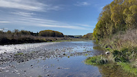
• 80 ★ 3.3 • 18 miles • 870 ft • 142 •
Lake2Lake Trail from Te Anau to Manapouri. Mostly wide gravel trail. A few loose off-camber corners to watch out for.
• 75 ★ 3.0 • 1,644 ft • 0 ft • 122 •
Rattle Ya Daggs is an access track, climbing from the Perenuka MTB Park entrance up to the start of the trails. Passing through a charming tunnel within a tree lane it has a couple of short sections of wide boardwalk, but as an exit...
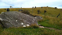
• 85 ★ 4.7 • 672 ft • 2 ft • 117 •
Highly rated popular black diamond difficulty singletrack. This mountain bike primary trail can be used downhill primary and has a moderate overall physical rating with a 2 ft black diamond climb. It features berm and jump. On average it takes 1 minutes to complete this trail.
• 45 ★ 3.7 • 4,507 ft • 149 ft • 109 •
Easy winding climb up to the top of the bike track and a wonderful view, or a nice winding downhill
• 50 ★ 2.8 • 2,878 ft • 76 ft • 97 •
Fast and flowing from the summit with big berms to shred! Lots of fun.
• 40 ★ 3.4 • 2,786 ft • 72 ft • 97 •
Moderately popular blue difficulty singletrack. This mountain bike primary trail can be used both directions and has a moderate overall physical rating with a 72 ft green climb. It features berm and bridge. On average it takes 5 minutes to complete this trail.
• 55 ★ 3.8 • 1,653 ft • 47 ft • 97 •
A steeper, and longer descent off the summit than . Well bermed corners so get off the brakes and let it hang out!
• 100 ★ 3.0 • 863 ft • 11 ft • 95 •
Add a bit of interest to your gravel grind. One of several short side tracks that come off between the L2L Trail and the Waiau River.
Photos of Te Anau Mountain Bike
Videos of Te Anau Mountain Bike
trail: Whitestone River B
0:41 |
17 |
Apr 13, 2023
trail: Whitestone River B
0:15 |
4 |
Apr 13, 2023
trail: I'm Rock I Am
0:04 |
515 |
Jul 2, 2021

trail: Rattle Ya Dags
1095 |
May 7, 2019 , Te Anau
Current Trail Warnings
| status | trail | date | condition | user | info |
|---|---|---|---|---|---|
| Fern Hurdle | Jun 7, 2026 @ 11:44am (Pacific/Auckland) Jun 6, 2026 | Unknown | Bike1Bike1Bike | Start and end of trail has been damaged... |
Recent Trail Reports
| status | trail | date | condition | info | user |
|---|---|---|---|---|---|
| Off Piste | Jun 16, 2026 @ 6:27pm (Pacific/Auckland) Jun 15, 2026 | Variable | Bike1Bike1Bike | ||
| 5G | Jun 16, 2026 @ 11:05am (Pacific/Auckland) Jun 15, 2026 | Variable | Bike1Bike1Bike | ||
| What's Up Doc | Jun 16, 2026 @ 11:04am (Pacific/Auckland) Jun 15, 2026 | Variable | Bike1Bike1Bike | ||
| Wazzamatagauri | Jul 12, 2025 @ 8:10pm Jul 12, 2025 | Variable | punkture | ||
| Ewe Turn | Jul 12, 2025 @ 8:09pm Jul 12, 2025 | Variable | punkture | ||
| Lake2Lake Te Anau to Manapouri | Jun 3, 2025 @ 10:46pm Jun 3, 2025 | Wet | georgeinafg | ||
| Outflow | Mar 28, 2025 @ 10:58am Mar 28, 2025 | Variable | mtbmarty54 | ||
| Pumpshed Alley | Mar 28, 2025 @ 10:58am Mar 28, 2025 | Ideal | mtbmarty54 | ||
| Aslan's How | Mar 28, 2025 @ 10:58am Mar 28, 2025 | Unknown | mtbmarty54 | ||
| Butch's Track | Jan 16, 2025 @ 4:25pm Jan 16, 2025 | Unknown | Bike1Bike1Bike |
Activity Feed
| username | action | type | title | date |
|---|---|---|---|---|
| Bike1Bike1Bike | add | report | activity #97089965 | Jun 15, 2026 @ 11:27pm Jun 15, 2026 |
| Bike1Bike1Bike | add | report | activity #97071240 and 1 more | Jun 15, 2026 @ 4:04pm Jun 15, 2026 |
| Martinmcnamara | wishlist | trail | activity #96438079 | Jun 7, 2026 @ 2:14am Jun 7, 2026 |
| Bike1Bike1Bike | add | report | activity #96415795 | Jun 6, 2026 @ 4:45pm Jun 6, 2026 |
| ADHDMI | ridden | trail | activity #91941826 and 11 more | Apr 4, 2026 @ 4:32pm Apr 4, 2026 |
Recent Comments
| username | type | title | comment | date |
|---|---|---|---|---|
| trail | This is a route spanning over multiple... | Jul 7, 2025 @ 2:26am Jul 7, 2025 | ||
| trail | Manapouri to Te Anau and back. Wet, cold but a... | Jun 3, 2025 @ 10:45pm Jun 3, 2025 | ||
| trail | Terribly overgrown and muddy in the middle.... | Dec 14, 2024 @ 9:09pm Dec 14, 2024 | ||
| trail | All fixed up and riding great! | Feb 5, 2023 @ 1:03am Feb 5, 2023 | ||
| trail | The car may look scary but it is pretty... | Dec 31, 2021 @ 1:00pm Dec 31, 2021 |
Local Badges
-

Epic Ride Climb 2k14 awarded -

Climbing 10k Badge5 awarded -

Climbing 100k Badge1 awarded -

Epic Ride Descent 2k14 awarded -

Descent 10k Badge5 awarded -

Descent 100k Badge1 awarded
Bike & Skill Parks
| name | type | city | rating |
|---|---|---|---|
| Te Anau Pumptrack and Skatepark | skill park | Te Anau |
Local Trail Supporters
- TACI
- T.A.C.I
![]()
- Fiordland Nursery
- Meridian Energry
- Meridian Energy
- Te Anau Enduro
Activity Type Stats
| activitytype | trails | distance | descent | descent distance | total vertical | rating | global rank | state rank | photos | reports | routes | ridelogs |
|---|---|---|---|---|---|---|---|---|---|---|---|---|
| Mountain Bike | 32 | 37 miles | 2,067 ft | 13 miles | 410 ft | #3,468 | #59 | 144 | 365 | 4,214 | ||
| E-Bike | 18 | 25 miles | 1,398 ft | 10 miles | 410 ft | #2,816 | #45 | 2 | 322 | 95 | ||
| Horse | 1 | 545 ft | 52 ft | 469 ft | 52 ft | 90 | ||||||
| Hike | 26 | 35 miles | 2,011 ft | 13 miles | 410 ft | #4,113 | #57 | 337 | 825 | |||
| Trail Running | 27 | 35 miles | 2,011 ft | 13 miles | 410 ft | #3,571 | #48 | 337 | 45 |
Frequently Asked Questions About Te Anau
▼
What are the best places to ride in Te Anau?
Te Anau has 2 areas to explore for mountain biking. The top rated areas are:
▼
What are the highest rated mountain biking trails in Te Anau?
The highest rated mountain biking trails in Te Anau are:
- I'm Rock I Am (4.4/5)
- Pork Pie (4.3/5)
- Bull Rush! (4.2/5)
- Little Elastrator (4/5)
- Auger (3.9/5)
▼
What is the best time of the year to ride in Te Anau?
Based on ride log data, the most popular months to ride in Te Anau are:
- February (60 activities)
- October (41 activities)
- December (34 activities)
▼
Where can I park to ride in Te Anau?
There are 5 parking locations listed in Te Anau. The most popular parking spots are:
- Parking
- Marakura Yacht Club Carpark
- Lake 2 Lake Trailhead Parking Lot
- Old Kepler Carpark
- Lookout Carpark
Activities
Trails
- By YogiNZ & contributors
- Admins: Alps2Ocean-Cycle-Trail
- #8310 - 11,786 views
- te anau activity log | embed map of Te Anau mountain bike trails | te anau mountain biking points of interest
Downloading of trail gps tracks in kml & gpx formats is enabled for Te Anau.
You must login to download files.