close
-
Layers w
- Weather Layers
- Pro
- Pro
- Pro
- Pro
- Pro
- Pro
- More Layers
- Pro
- Pro
- Pro
- Pro
-
Upgrade to

3D
Trail Conditions
- Unknown
- Snow Groomed
- Snow Packed
- Snow Covered
- Snow Cover Partial
- Freeze/thaw Cycle
- Icy
- Prevalent Mud
- Wet
- Variable
- Ideal
- Dry
- Very Dry
Trail Flow (Ridden Direction)
Trailforks scans users ridelogs to determine the most popular direction each trail is ridden. A good flowing trail network will have most trails flowing in a single direction according to their intension.
The colour categories are based on what percentage of riders are riding a trail in its intended direction.
The colour categories are based on what percentage of riders are riding a trail in its intended direction.
- > 96%
- > 90%
- > 80%
- > 70%
- > 50%
- < 50%
- bi-directional trail
- no data
Trail Last Ridden
Trailforks scans ridelogs to determine the last time a trail was ridden.
- < 2 days
- < 1 week
- < 2 weeks
- < 1 month
- < 6 months
- > 6 months
Trail Ridden Direction
The intended direction a trail should be ridden.
- Downhill Only
- Downhill Primary
- Both Directions
- Uphill Primary
- Uphill Only
- One Direction
Contribute Details
Colors indicate trail is missing specified detail.
- Description
- Photos
- Description & Photos
- Videos
Trail Popularity ?
Trailforks scans ridelogs to determine which trails are ridden the most in the last 9 months.
Trails are compared with nearby trails in the same city region with a possible 25 colour shades.
Think of this as a heatmap, more rides = more kinetic energy = warmer colors.
- most popular
- popular
- less popular
- not popular
ATV/ORV/OHV Filter
Max Vehicle Width
inches
US Cell Coverage
Legend

Radar Time
Activity Recordings
Trailforks uses anonymized public activity data.
?
Activity Recordings
Trailforks uses anonymized public activity data.
?
Personal Heatmap
▶
Activity Types
all
/
none
▶
Options
2
Date range
month
–
Winter Trails
Warning
A routing network for winter maps does not exist. Selecting trails using the winter trails layer has been disabled.
Missing Trails
Most Popular
Least Popular
Trails are colored based on popularity. The more popular a trail is, the more red. Less popular trails trend towards green.
Jump Magnitude Heatmap
Heatmap of where riders jump on trails. Zoom in to see individual jumps, click circles to view jump details.
BC Backroad Status
![map legend]()
Service Road Atlas is a free to use, community-driven service for viewing and creating reports on the numerous back-country service roads around B.C. and Alberta.

Slope Aspect
Direction the slope faces
Trails Deemphasized
Trails are shown in grey.
Only show trails with no bike usage.
Suggested Layers
Based on selected activity type
Save the current map location and zoom level as your default home location whenever this page is loaded.
SaveActivities Click to view
- Mountain Bike
72 trails
- E-Bike
37 trails
- Gravel Bike
0 trails
- Adaptive Bike
0 trails
- Winter Fat Bike
0 trails
- Horse
3 trails
- Hike
95 trails
- Trail Running
95 trails
- Snowshoe
15 trails
- Downhill Ski
30 trails
- Nordic Ski
25 trails
Region Details
- 5
- 2
- 15
- 22
- 21
- 5
- 2
Region Status
Caution as of 2 daysStats
- Avg Trail Rating
- Trails (view details)
- 134
- Trails Mountain Bike
- 73
- Trails E-Bike
- 37
- Trails Horse
- 3
- Trails Hike
- 95
- Trails Trail Running
- 95
- Trails Snowshoe
- 15
- Trails Downhill Ski
- 30
- Trails Nordic Ski
- 25
- Total Distance
- 107 miles
- Total Descent
- 34,360 ft
- Total Vertical
- 6,412 ft
- Highest Trailhead
- 6,594 ft
- Reports
- 1,554
- Photos
- 623
- Ridden Counter
- 13,946
Articles
Exploring Northern British Columbia By Bike & Train
Aug 5, 2020 from pinkbike.com
A dream trip to some of British Columbia's lesser-known, but still world-class, ride locations.
Sub Regions
-
Copper Mountain
- 2
- 8
- 12
- 4
- 2
-
Maroon Mountain
- 1
-
Oliver Creek
-
Seven Sisters
- 1
-
Terrace Mountain
- 7
- 11
- 9
- 1
Popular Terrace Mountain Biking Trails
• 100 ★ 4.0 • 4,872 ft • 112 ft • 680 •
has a brand new exit that veers left around the 1.4 km mark. This new section is feature-rich with berms, rollers and side hits. The new exit drops riders about 50m away from where the old exit was, connecting to Spring Creek. Other...
• 100 ★ 4.6 • 2 miles • 703 ft • 604 •
A Terrace favourite trail. Ridge Trail from the Spring Creek side is an excellent climb with some technical, punchy sections and some flow to help you catch your breath. This trail is the next progression in skill level/difficulty from...
• 95 ★ 4.9 • 3,199 ft • 34 ft • 507 •
As the name suggests, is a slice of heaven on earth. It's a "choose your own adventure" kind of trail with optional features around every elbow-dragging corner. When you're not ripping down beautifully sculpted dirt, you're hitting rock...
• 100 ★ 4.0 • 1,358 ft • 78 ft • 485 •
is a multi-use trail frequented by horseback riders and hikers. It is the main trail used to access ! Keep an eye out for other trail users and check your speed on the descent as this is a bi-directional trail.
• 90 ★ 4.6 • 1 mile • 53 ft • 370 •
Berms and rock slabs. Off camber corners in clay section below are slippery when wet.
• 95 ★ 4.3 • 1 mile • 168 ft • 360 •
This is Terrace's first sanctioned green trail. This loop weaves through a moss-covered second-growth hemlock forest. Easy climbs and thrilling descents with optional side hits along the way. Easy enough for the novice rider to get...
• 100 ★ 4.0 • 413 ft • 7 ft • 331 •
Short connector from the first Lichen Junction to access without having to do the full .
Terrace Mountain Bike Routes
5 miles • 916 ft • 4 •
This is the go-to quick after work pedal loop. Usually takes most people an hour or less.
★ 4.0 • 4 miles • 870 ft • 4 • Loop •
Popular route to session Shangri-La, good times all-round. Begins with a demanding climb up Steinhoe...
★ 4.0 • 4 miles • 1,064 ft • 4 • Point to Point •
Climb up then, at the @4.25kms mark, enter the rideable, but incomplete trail, Griff's line. You will...
5 miles • 1,186 ft • 6 •
Since it opened in 2016, Down Tube has quickly become a favourite. You'll hear most local riders saying...
6 miles • 1,290 ft • 6 • Point to Point •
Easiest route to collect 5 cards for a poker hand for the 2018 Rusty Chain Poker Ride presented by TORCA....
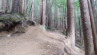
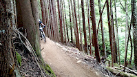
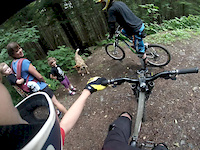
Photos of Terrace Mountain Bike
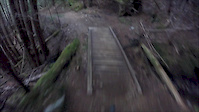
Videos of Terrace Mountain Bike

trail: Shangri-La
8:19 |
39 |
Jul 10, 2024
trail: Spring Creek (to Steinhoe)
14:21 |
174 |
Jun 18, 2020
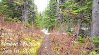
trail: Maroon Mountain
0:04 |
95 |
Jun 13, 2020
trail: Maroon Mountain
0:55 |
102 |
May 31, 2020
trail: Packhorse
0:07 |
364 |
Jun 26, 2018
trail: Packhorse
3:46 |
270 |
Aug 10, 2017
trail: Packhorse
0:07 |
313 |
Aug 23, 2015
trail: Leftover
0:15 |
174 |
Sep 18, 2014
Recent Trail Reports
| status | trail | date | condition | info | user |
|---|---|---|---|---|---|
| Your mom | Jun 27, 2026 @ 6:44pm (America/Vancouver) 2 days | Ideal | NickKJHQbQ | ||
| Lil jump run | Jun 27, 2026 @ 6:42pm (America/Vancouver) 2 days | Ideal | NickKJHQbQ | ||
| Babyweight | Jun 27, 2026 @ 6:40pm (America/Vancouver) 2 days | Variable | NickKJHQbQ | ||
| Packhorse | Jun 27, 2026 @ 6:38pm (America/Vancouver) 2 days | Ideal | NickKJHQbQ | ||
| Lucky Seven | Jun 27, 2026 @ 6:37pm (America/Vancouver) 2 days | Ideal | NickKJHQbQ | ||
| Lower Wheel Of Fortune | Jun 13, 2026 @ 11:07pm (America/Vancouver) Jun 13, 2026 | Ideal | Wildcat12985 | ||
| Hey Boo Boo | Jun 7, 2026 @ 4:21pm (America/Vancouver) Jun 7, 2026 | Unknown | KateriClay | ||
| Hey Boo-Boo | Jun 5, 2026 @ 7:07am (America/Vancouver) Jun 5, 2026 | Ideal | larissacb TORCA | ||
| Flathead | May 27, 2026 @ 1:56pm (America/Vancouver) May 27, 2026 | Ideal | antonio7650 | ||
| Wade's World | May 22, 2026 @ 8:34pm (America/Vancouver) May 22, 2026 | Variable | jCGIgi |
Activity Feed
| username | action | type | title | date |
|---|---|---|---|---|
| NickKJHQbQ | add | report | activity #97953593 and 4 more | Jun 27, 2026 @ 6:37pm 2 days |
| NickKJHQbQ | ridden | trail | activity #97953490 and 4 more | Jun 27, 2026 @ 6:34pm 2 days |
| ghammond | wishlist | trail | activity #97841378 | Jun 26, 2026 @ 9:54am Jun 26, 2026 |
| george45 | add | karma | activity #97552712 | Jun 22, 2026 @ 4:20am Jun 22, 2026 |
| chubby5000 | comment | trail | activity #97362857 and 2 more | Jun 19, 2026 @ 8:00pm Jun 19, 2026 |
Recent Comments
| username | type | title | comment | date |
|---|---|---|---|---|
| trail | This was SUCH a good trail. Kiiinda reminded... | Jun 19, 2026 @ 8:29pm Jun 19, 2026 | ||
| trail | Damn this is a fun trail. I met some gals from... | Jun 19, 2026 @ 8:26pm Jun 19, 2026 | ||
| trail | Such a pretty climb. Rode there in mid June... | Jun 19, 2026 @ 8:00pm Jun 19, 2026 | ||
| trail | Just rode for the first time today. It rips!... | May 16, 2026 @ 10:03pm May 16, 2026 | ||
| trail | The best trail in Terrace! | May 16, 2026 @ 9:40pm May 16, 2026 |
Local Badges
-

Spring Creek Full Pull2 awarded -
2021 TORCA 30 Day Challenge Special - Flathead Flatout27 awarded -

2021 TORCA 30 Day Challenge - Day 2443 awarded -

2021 TORCA 30 Day Challenge - Day 2532 awarded -

2021 TORCA 30 Day Challenge - Day 668 awarded -

2021 TORCA 30 Day Challenge - Day 2738 awarded
Bike & Skill Parks
| name | type | city | rating |
|---|---|---|---|
| The HuB Pump Track | skill park | Terrace | |
| Terrace Rotary Bicycle Skills Park | skill park | Terrace |
Local Trail Supporters
- DIG trail design
- Tony Moore
- Noble 5 Creek Ltd
- Terrace Community Forest
Activity Type Stats
| activitytype | trails | distance | descent | descent distance | total vertical | rating | global rank | state rank | photos | reports | routes | ridelogs |
|---|---|---|---|---|---|---|---|---|---|---|---|---|
| Mountain Bike | 72 | 58 miles | 20,285 ft | 29 miles | 4,659 ft | #919 | #49 | 583 | 1,551 | 17 | 26,266 | |
| E-Bike | 37 | 39 miles | 9,688 ft | 18 miles | 4,659 ft | #2,382 | #62 | 908 | 1 | 409 | ||
| Horse | 3 | 7 miles | 545 ft | 3 miles | 407 ft | #1,353 | #50 | 674 | ||||
| Hike | 95 | 86 miles | 19,606 ft | 34 miles | 6,411 ft | #1,216 | #58 | 28 | 1,490 | 2,095 | ||
| Trail Running | 95 | 86 miles | 19,606 ft | 34 miles | 6,411 ft | #438 | #27 | 4 | 1,490 | 5,945 | ||
| Snowshoe | 15 | 25 miles | 1,850 ft | 7 miles | 5,003 ft | #488 | #42 | 440 | 31 | |||
| Downhill Ski | 30 | 13 miles | 12,087 ft | 13 miles | 1,427 ft | #428 | #21 | 4 | 389 | |||
| Nordic Ski | 25 | 25 miles | 1,736 ft | 10 miles | 407 ft | #422 | #27 | 408 | 944 |
Frequently Asked Questions About Terrace
▼
What are the best places to ride in Terrace?
Terrace has 10 areas to explore for mountain biking. The top rated areas are:
▼
What are the highest rated mountain biking trails in Terrace?
The highest rated mountain biking trails in Terrace are:
- Shangri-La (4.6/5)
- Oliver Creek Trail (4.5/5)
- Maroon Mountain (4.5/5)
- (Not) Slippery When Wet (4.4/5)
- Your mom (4.4/5)
▼
What is the best time of the year to ride in Terrace?
Based on ride log data, the most popular months to ride in Terrace are:
- June (1,794 activities)
- July (526 activities)
- May (344 activities)
▼
Where can I park to ride in Terrace?
There are 16 parking locations listed in Terrace. The most popular parking spots are:
- Spring Creek Parking
- Kitselas Road Parking
- Various Parking Spots.
- The HuB Project Staging Area (Sportsplex Overflow Parking)
- Lower Parking Lot
Activities
Trails
Points of Interest
- Skeena Valley Viewpoint
- Second Lookout Viewpoint
- Lichen Lookout Viewpoint
- Skeena Lookout Viewpoint
- Return to Sender TTF
- Copper Lookout Viewpoint
- Lakelse Lake Campground Camping
- Gunsight Peak Summit
- Kleanza Creek Campground Camping
- Wesach Mountain Summit
- Weeskinisht Peak (2,703 m)
- Seven Sisters Peaks (2,555 m)
- Seven Sisters Peaks (2,466 m)
- By brenthillier
 NSMBA TRAILFORKS & contributors
 - Admins: BCBR, TrailsBC, BCORMA, DSBC, wheelmaniac3, bcpunk, TORCA, aleksa, tashpapa, larissacb
- #3361 - 35,412 views
- terrace activity log | embed map of Terrace mountain bike trails | terrace mountain biking points of interest polygons
Downloading of trail gps tracks in kml & gpx formats is enabled for Terrace.
You must login to download files.