close
-
Layers w
- Weather Layers
- Pro
- Pro
- Pro
- Pro
- Pro
- Pro
- More Layers
- Pro
- Pro
- Pro
- Pro
-
Upgrade to

3D
Trail Conditions
- Unknown
- Snow Groomed
- Snow Packed
- Snow Covered
- Snow Cover Partial
- Freeze/thaw Cycle
- Icy
- Prevalent Mud
- Wet
- Variable
- Ideal
- Dry
- Very Dry
Trail Flow (Ridden Direction)
Trailforks scans users ridelogs to determine the most popular direction each trail is ridden. A good flowing trail network will have most trails flowing in a single direction according to their intension.
The colour categories are based on what percentage of riders are riding a trail in its intended direction.
The colour categories are based on what percentage of riders are riding a trail in its intended direction.
- > 96%
- > 90%
- > 80%
- > 70%
- > 50%
- < 50%
- bi-directional trail
- no data
Trail Last Ridden
Trailforks scans ridelogs to determine the last time a trail was ridden.
- < 2 days
- < 1 week
- < 2 weeks
- < 1 month
- < 6 months
- > 6 months
Trail Ridden Direction
The intended direction a trail should be ridden.
- Downhill Only
- Downhill Primary
- Both Directions
- Uphill Primary
- Uphill Only
- One Direction
Contribute Details
Colors indicate trail is missing specified detail.
- Description
- Photos
- Description & Photos
- Videos
Trail Popularity ?
Trailforks scans ridelogs to determine which trails are ridden the most in the last 9 months.
Trails are compared with nearby trails in the same city region with a possible 25 colour shades.
Think of this as a heatmap, more rides = more kinetic energy = warmer colors.
- most popular
- popular
- less popular
- not popular
ATV/ORV/OHV Filter
Max Vehicle Width
inches
US Cell Coverage
Legend

Radar Time
Activity Recordings
Trailforks uses anonymized public activity data.
?
Activity Recordings
Trailforks uses anonymized public activity data.
?
Personal Heatmap
▶
Activity Types
all
/
none
▶
Options
2
Date range
month
–
Winter Trails
Warning
A routing network for winter maps does not exist. Selecting trails using the winter trails layer has been disabled.
Missing Trails
Most Popular
Least Popular
Trails are colored based on popularity. The more popular a trail is, the more red. Less popular trails trend towards green.
Jump Magnitude Heatmap
Heatmap of where riders jump on trails. Zoom in to see individual jumps, click circles to view jump details.
BC Backroad Status
![map legend]()
Service Road Atlas is a free to use, community-driven service for viewing and creating reports on the numerous back-country service roads around B.C. and Alberta.

Slope Aspect
Direction the slope faces
Trails Deemphasized
Trails are shown in grey.
Only show trails with no bike usage.
Suggested Layers
Based on selected activity type
Save the current map location and zoom level as your default home location whenever this page is loaded.
Save
No description for Terre Haute has been added yet!
Login or register to submit one.
Activities Click to view
- Mountain Bike
33 trails
- E-Bike
30 trails
- Gravel Bike
0 trails
- Adaptive Bike
0 trails
- Winter Fat Bike
0 trails
- Hike
30 trails
- Trail Running
33 trails
Region Details
- 3
- 3
- 9
- 3
- 7
- 5
Region Status
Closed as of 1 dayLocal Trail Association
Stats
- Avg Trail Rating
- Trails (view details)
- 34
- Trails Mountain Bike
- 40
- Trails E-Bike
- 30
- Trails Horse
- 2
- Trails Hike
- 31
- Trails Trail Running
- 33
- Trails Dirtbike/Moto
- 3
- Trails Observed Trials
- 2
- Trails ATV/ORV/OHV
- 3
- Trails Backcountry Ski
- 1
- Total Distance
- 39 miles
- Total Descent
- 1,967 ft
- Total Vertical
- 210 ft
- Highest Trailhead
- 670 ft
- Reports
- 23,557
- Photos
- 147
- Ridden Counter
- 9,359
Sub Regions
-
Griffin Bike Park
- 1
- 9
- 3
- 7
- 5
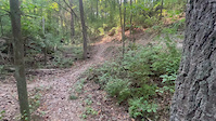
Popular Terre Haute Mountain Biking Trails
• 95 ★ 5.0 • 1,280 ft • 18 ft • 306 •
Warrior Trail is a half-mile adaptive loop trail built for hand-cranked mountain bikes, all-terrain wheelchairs and conventional mountain bikes. Enter from the southern parking lot and park access road. The trail flows...
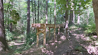
• 80 ★ 4.6 • 541 ft • 12 ft • 290 •
From the Trail riders pass under a wooden gantry and make a winding gentle climb to the first (advanced) drop. This steep descent is made even more challenging by loose, sandy soil. At the bottom, those with momentum can ride a berm...
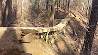
• 55 ★ 4.0 • 1,621 ft • 36 ft • 277 •
This trail allows access to the gravity-oriented features of the Landing Zone Skills Park, including the starting gate, and drop-ins for the five jump lines.
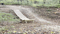
• 90 ★ 5.0 • 1,033 ft • 0 ft • 263 •
Challenge a friend in a race to the bottom! This short, 45-second section of trail will leave you wanting to do it again and again. Starting at the hilltop at a wooden start gate, choose your lane, right or left. Both have the same...
• 35 ★ 3.8 • 243 ft • 0 ft • 230 •
This trail is a floating metal pontoon bridge traversing Stryker Lake.
Terre Haute Mountain Bike Routes
★ 5.0 • 4 miles • 164 ft • 3 • Loop •
This mostly 10-ft.-wide loop has been optimized for adaptive MTB riders and youth racing, with NICA...
★ 5.0 • 7 miles • 427 ft • 13 •
his trail starts with the "fingers" series of switchbacks and straightens out to a flowing section leading...
12 miles • 2,048 ft • 14 • Loop •
More of an adventure ride, a lot of access road climbing, mixed with some technical XC and AM. If ridden...
★ 3.4 • 3 miles • 217 ft • 7 • Loop •
This trail circumnavigates Stryker Lake and offers gorgeous views of the lake. Marked by the Yellow Shield...
• 17 miles • 1,400 ft • 33 •
• 4 miles • 244 ft • 6 •
Photos of Terre Haute Mountain Bike
Videos of Terre Haute Mountain Bike
trail: AWOL
0:09 |
14 |
Oct 27, 2024

trail: AWOL
0:42 |
69 |
Jan 25, 2024
trail: Recon Trail
0:05 |
355 |
Aug 5, 2022
trail: AWOL
0:08 |
|
Nov 16, 2021
trail: KA-BAR
0:22 |
218 |
Jan 18, 2021
trail: KA-BAR
0:08 |
123 |
Jan 18, 2021

trail: KA-BAR
0:12 |
187 |
Jan 18, 2021

trail: Alpha
0:12 |
90 |
Jan 18, 2021
Recent Trail Reports
Activity Feed
| username | action | type | title | date |
|---|---|---|---|---|
| RichMoore65 | add | report | activity #97422457 and 34 more | Jun 20, 2026 @ 12:23pm 1 day |
| Stash217 | wishlist | region | activity #97259199 | Jun 18, 2026 @ 9:53am Jun 18, 2026 |
| RichMoore65 | add | report | activity #97160072 and 34 more | Jun 16, 2026 @ 8:34pm Jun 16, 2026 |
| KevinDT6v | add | report | activity #97102146 | Jun 16, 2026 @ 5:29am Jun 16, 2026 |
| RichMoore65 | add | report | activity #97065560 and 34 more | Jun 15, 2026 @ 2:26pm Jun 15, 2026 |
Recent Comments
| username | type | title | comment | date |
|---|---|---|---|---|
| trail | wowwww | Feb 9, 2024 @ 4:27am Feb 9, 2024 | ||
| trail | Great trail with some fun features. | Sep 23, 2023 @ 7:40pm Sep 23, 2023 | ||
| trail | Out of all the trails at Griffin, AWOL puts... | Mar 18, 2022 @ 9:24am Mar 18, 2022 | ||
| report | Tree down | May 14, 2021 @ 11:17am May 14, 2021 | ||
| trail | I want to ride it so bad | Sep 6, 2020 @ 8:22pm Sep 6, 2020 |
Local Badges
-

Epic Ride Climb 2k2 awarded -

Climbing 10k Badge8 awarded -

Climbing 100k Badge0 awarded -

Epic Ride Descent 2k2 awarded -

Descent 10k Badge7 awarded -

Descent 100k Badge0 awarded
Activity Type Stats
| activitytype | trails | distance | descent | descent distance | total vertical | rating | global rank | state rank | photos | reports | routes | ridelogs |
|---|---|---|---|---|---|---|---|---|---|---|---|---|
| Mountain Bike | 33 | 39 miles | 1,952 ft | 12 miles | 210 ft | #2,321 | #830 | 149 | 25,229 | 2 | 5,706 | |
| E-Bike | 30 | 26 miles | 1,667 ft | 9 miles | 197 ft | #820 | #767 | 24,275 | 2 | 146 | ||
| Horse | 2 | 587 ft | 13 ft | 299 ft | 30 ft | 3,878 | ||||||
| Hike | 30 | 31 miles | 1,339 ft | 9 miles | 207 ft | #6,147 | #2,164 | 3 | 24,510 | 2 | 428 | |
| Trail Running | 33 | 31 miles | 1,339 ft | 9 miles | 207 ft | #5,686 | #1,810 | 24,510 | 2 | 21 | ||
| Dirtbike/Moto | 3 | 561 ft | 26 ft | 16 ft | 3,879 | |||||||
| Observed Trials | 2 | 4,593 ft | 95 ft | 1,742 ft | 30 ft | 1 | 1 | |||||
| ATV/ORV/OHV | 3 | 545 ft | 112 ft | 10 ft | 3,878 | 1 | ||||||
| Backcountry Ski | 1 | 36 ft | 10 ft | 1 | 7 |
Frequently Asked Questions About Terre Haute
▼
What are the best places to ride in Terre Haute?
Terre Haute has 1 areas to explore for mountain biking. The top rated areas are:
▼
What are the highest rated mountain biking trails in Terre Haute?
The highest rated mountain biking trails in Terre Haute are:
- AWOL (4.5/5)
- Zulu (4.3/5)
- Proving Grounds Advanced Drop (4.3/5)
- Recon Trail (4.2/5)
- Basic Training Skills Trail (4.2/5)
▼
What is the best time of the year to ride in Terre Haute?
Based on ride log data, the most popular months to ride in Terre Haute are:
- September (61 activities)
- May (47 activities)
- October (45 activities)
▼
Where can I park to ride in Terre Haute?
There are 5 parking locations listed in Terre Haute. The most popular parking spots are: View all parking and trailhead locations on the map to plan your visit.
Activities
Trails
- By Warburrito & contributors
- Admins: HMBA
- #8901 - 5,317 views
- terre haute activity log | embed map of Terre Haute mountain bike trails | terre haute mountain biking points of interest
Downloading of trail gps tracks in kml & gpx formats is enabled for Terre Haute.
You must login to download files.