close
-
Layers w
- Weather Layers
- Pro
- Pro
- Pro
- Pro
- Pro
- Pro
- More Layers
- Pro
- Pro
- Pro
- Pro
-
Upgrade to

3D
Trail Conditions
- Unknown
- Snow Groomed
- Snow Packed
- Snow Covered
- Snow Cover Partial
- Freeze/thaw Cycle
- Icy
- Prevalent Mud
- Wet
- Variable
- Ideal
- Dry
- Very Dry
Trail Flow (Ridden Direction)
Trailforks scans users ridelogs to determine the most popular direction each trail is ridden. A good flowing trail network will have most trails flowing in a single direction according to their intension.
The colour categories are based on what percentage of riders are riding a trail in its intended direction.
The colour categories are based on what percentage of riders are riding a trail in its intended direction.
- > 96%
- > 90%
- > 80%
- > 70%
- > 50%
- < 50%
- bi-directional trail
- no data
Trail Last Ridden
Trailforks scans ridelogs to determine the last time a trail was ridden.
- < 2 days
- < 1 week
- < 2 weeks
- < 1 month
- < 6 months
- > 6 months
Trail Ridden Direction
The intended direction a trail should be ridden.
- Downhill Only
- Downhill Primary
- Both Directions
- Uphill Primary
- Uphill Only
- One Direction
Contribute Details
Colors indicate trail is missing specified detail.
- Description
- Photos
- Description & Photos
- Videos
Trail Popularity ?
Trailforks scans ridelogs to determine which trails are ridden the most in the last 9 months.
Trails are compared with nearby trails in the same city region with a possible 25 colour shades.
Think of this as a heatmap, more rides = more kinetic energy = warmer colors.
- most popular
- popular
- less popular
- not popular
ATV/ORV/OHV Filter
Max Vehicle Width
inches
US Cell Coverage
Legend

Radar Time
Activity Recordings
Trailforks uses anonymized public activity data.
?
Activity Recordings
Trailforks uses anonymized public activity data.
?
Personal Heatmap
▶
Activity Types
all
/
none
▶
Options
2
Date range
month
–
Winter Trails
Warning
A routing network for winter maps does not exist. Selecting trails using the winter trails layer has been disabled.
Missing Trails
Most Popular
Least Popular
Trails are colored based on popularity. The more popular a trail is, the more red. Less popular trails trend towards green.
Jump Magnitude Heatmap
Heatmap of where riders jump on trails. Zoom in to see individual jumps, click circles to view jump details.
BC Backroad Status
![map legend]()
Service Road Atlas is a free to use, community-driven service for viewing and creating reports on the numerous back-country service roads around B.C. and Alberta.

Slope Aspect
Direction the slope faces
Trails Deemphasized
Trails are shown in grey.
Only show trails with no bike usage.
Suggested Layers
Based on selected activity type
Save the current map location and zoom level as your default home location whenever this page is loaded.
Save“The Pass” contains some of the first mountain bike specific trails on National Forest land in the US. Downhill specific expert-level freeride and jump trails were originally the vision of the legendary Teton Free Riders and are still maintained by them today. There’s also a handful of fun, intermediate technical cross-country trails mixed in for an all-inclusive experience in the heart of the Tetons.
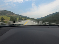
 google parking directions
IMBA Ride Center

Teton Region
Activities Click to view
- Mountain Bike
20 trails
- Horse
10 trails
- Hike
27 trails
- Trail Running
27 trails
- Backcountry Ski
2 trails
Region Details
- 2
- 2
- 10
- 4
- 2
Region Status
Caution as of Jun 10, 2026Stats
- Avg Trail Rating
- Trails (view details)
- 32
- Trails Mountain Bike
- 21
- Trails Horse
- 10
- Trails Hike
- 27
- Trails Trail Running
- 27
- Trails Snowshoe
- 2
- Trails Downhill Ski
- 1
- Trails Backcountry Ski
- 2
- Trails Nordic Ski
- 2
- Total Distance
- 65 miles
- Total Descent
- 16,198 ft
- Total Vertical
- 3,931 ft
- Highest Trailhead
- 10,080 ft
- Reports
- 392
- Photos
- 657
- Ridden Counter
- 11,156
Articles
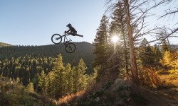
Video: Unreal Flow Trails in Wyoming's Wild Frontier in 'Grindstone'
Mar 16, 2022 from pinkbike.com
And Nick Clark hits them with style.
When a Popular Backcountry Spot Became Overcrowded and Unsafe, Volunteers Stepped in To Manage It
Jan 10, 2022 from skimag.com
As backcountry trailheads like the one on Wyoming's Teton Pass outside of Jackson Hole get more crowded, responsible recreation practices are more...
Popular Teton Pass Mountain Biking Trails
• 95 ★ 4.4 • 2,493 ft • 0 ft • 950 •
Fast and flowing with big jump options and some pretty crazy gap jumps. You can ride around everything, which will give you a chance to look before you leap. Not a beginner friendly trail.
• 95 ★ 3.0 • 3,638 ft • 0 ft • 807 •
Singletrack on north side of Hwy. 22 as you descend to Wilson from the Trail Creek Trailhead.
• 80 ★ 4.3 • 3 miles • 60 ft • 792 •
Fun and challenging technical descent. Watch out for uphill traffic!
• 80 ★ 4.5 • 3 miles • 65 ft • 777 •
This is an awesome downhill trail. Really fast and flowy at the top. Some gap jumps made from logs will come up on you fast. Trail starts to get really rocky once you hit the ridge. Then the ridge starts to gown down steep and can be...
• 65 ★ 4.5 • 5 miles • 237 ft • 762 •
Fun single track with lots of high speed sections. Most people ride down this trail but it is multi use and gets uphill traffic as well. Keep an eye out for hikers and equestrians particularly near the bottom.
• 70 ★ 4.0 • 9 miles • 2,480 ft • 654 •
The Ridge Trail connects the Phillip's Trailhead to Fish Creek Road. It was graded at 5-8% to be a good climb for mountain bikes.
Teton Pass Mountain Bike Routes
21 miles • 3,751 ft • 4 • Shuttled •
Start at Mail Cabin and hang a left (south) instead of going down Mikesell. Drop into the wild and thick...
10 miles • 1,781 ft • 4 • Point to Point •
A Teton classic. This route can be ridden in either direction. Some route-finding may be necessary on the...
11 miles • 2,086 ft • 5 • Point to Point •
A Teton classic. Ride this in a clockwise direction. Easy to ride back to Victor from the Mike Harris TH...
25 miles • 3,632 ft • 23 • Shuttled •
Shuttle Ride Start at the top of Teton Pass head out on towards . Saddle up and get ready for , this is...
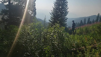
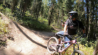
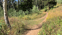
Photos of Teton Pass Mountain Bike
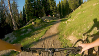
Videos of Teton Pass Mountain Bike
trail: Lithium
8:30 |
194 |
Sep 24, 2021
trail: Lithium
7:48 |
68 |
Sep 22, 2021

trail: Jimmy's Mom
6:18 |
43 |
Sep 13, 2021
trail: Fuzzy Bunny
3:05 |
132 |
Sep 9, 2021
trail: Lithium
0:07 |
655 |
Sep 8, 2021

trail: Parallel
0:31 |
148 |
May 13, 2021
trail: Fuzzy Bunny
0:10 |
368 |
Sep 20, 2019
trail: Jimmy's Mom
3:43 |
418 |
Jun 12, 2019
Recent Trail Reports
| status | trail | date | condition | info | user |
|---|---|---|---|---|---|
| Black Canyon | Jun 10, 2026 @ 9:48am (America/Denver) Jun 10, 2026 | Snow Covered | phoenixsun | ||
| Lithium | Jun 10, 2026 @ 8:15am (America/Denver) Jun 10, 2026 | Ideal | Joemannn1 | ||
| Phillips Canyon | May 11, 2026 @ 6:20pm (America/Denver) May 11, 2026 | Variable | timreid845 | ||
| Mail Cabin | Apr 23, 2026 @ 9:47am (America/Boise) Apr 23, 2026 | Snow Cover Partial | cremebrule MBT | ||
| Arrow | Apr 23, 2026 @ 9:44am (America/Denver) Apr 23, 2026 | Snow Cover Partial | cremebrule MBT | ||
| Phillip's Connector | Apr 23, 2026 @ 9:44am (America/Denver) Apr 23, 2026 | Snow Cover Partial | cremebrule MBT | ||
| Phillip's Ridge Trail | Apr 23, 2026 @ 9:43am (America/Denver) Apr 23, 2026 | Snow Cover Partial | cremebrule MBT | ||
| Snotel | Apr 23, 2026 @ 9:43am (America/Denver) Apr 23, 2026 | Snow Cover Partial | cremebrule MBT | ||
| Black Canyon | Apr 23, 2026 @ 9:41am (America/Denver) Apr 23, 2026 | Snow Covered | cremebrule MBT | ||
| Mount Elly Summit | Apr 23, 2026 @ 9:41am (America/Denver) Apr 23, 2026 | Snow Covered | cremebrule MBT |
Activity Feed
| username | action | type | title | date |
|---|---|---|---|---|
| kafrazier | ridden | trail | activity #97421621 | Jun 20, 2026 @ 12:14pm 23 hours |
| 2998BqZ9 | wishlist | route | activity #96987948 | Jun 14, 2026 @ 11:07am Jun 14, 2026 |
| Grb | comment | trail | activity #96937100 | Jun 13, 2026 @ 8:47pm Jun 13, 2026 |
| BirdBram | comment | trail | activity #96923739 | Jun 13, 2026 @ 4:08pm Jun 13, 2026 |
| phoenixsun | add | report | activity #96691080 | Jun 10, 2026 @ 12:54pm Jun 10, 2026 |
Recent Comments
| username | type | title | comment | date |
|---|---|---|---|---|
| trail | Ddd | Jun 13, 2026 @ 8:47pm Jun 13, 2026 | ||
| trail | Still snow patches requiring dismounting bike... | Jun 13, 2026 @ 4:08pm Jun 13, 2026 | ||
| trail | One of the best trails I have ever ridden. ... | Sep 25, 2025 @ 5:09am Sep 25, 2025 | ||
| trail | Trail is a bit steep and brake bumpy at the... | Sep 8, 2025 @ 7:46pm Sep 8, 2025 | ||
| trail | Super fun, tons of well built BIG jumps. | Aug 28, 2025 @ 7:17pm Aug 28, 2025 |
Nearby Areas
| name | distance | ||||
|---|---|---|---|---|---|
| High School Butte | 6.4 km | ||||
| Jackson Hole Mountain Resort | 5 | 11 | 2 | 3 | 6.8 km |
| Mike Harris | 2 | 11 | 12 | 7.7 km | |
| Snake River Range | 2 | 1 | 8.4 km | ||
| Snow King Mountain | 10 | 27 | 5 | 9 km |
Local Badges
-

Completionist1 awarded
Local Products
Activity Type Stats
| activitytype | trails | distance | descent | descent distance | total vertical | rating | global rank | state rank | photos | reports | routes | ridelogs |
|---|---|---|---|---|---|---|---|---|---|---|---|---|
| Mountain Bike | 20 | 42 miles | 12,290 ft | 22 miles | 3,104 ft | #2,222 | #759 | 645 | 390 | 8 | 8,388 | |
| Horse | 10 | 17 miles | 2,707 ft | 4 miles | 3,235 ft | #1,461 | #742 | 76 | 1 | |||
| Hike | 27 | 57 miles | 11,289 ft | 21 miles | 3,770 ft | #3,707 | #1,295 | 5 | 313 | 640 | ||
| Trail Running | 27 | 57 miles | 11,289 ft | 21 miles | 3,770 ft | #3,287 | #880 | 7 | 313 | 139 | ||
| Snowshoe | 2 | 6 | 3 | |||||||||
| Downhill Ski | 1 | 5 | ||||||||||
| Backcountry Ski | 2 | 5 miles | 1,558 ft | 2 miles | 1,932 ft | #54 | #16 | 1 | 1 | 1,404 | ||
| Nordic Ski | 2 | 6 | 30 |
Frequently Asked Questions About Teton Pass
▼
What are the highest rated mountain biking trails in Teton Pass?
The highest rated mountain biking trails in Teton Pass are:
- Parallel (4.6/5)
- Candyland (4.5/5)
- Lithium (4.4/5)
- Fuzzy Bunny (4.4/5)
- Powerline Jumps (4.3/5)
▼
What is the best time of the year to ride in Teton Pass?
Based on ride log data, the most popular months to ride in Teton Pass are:
- July (269 activities)
- August (144 activities)
- June (111 activities)
▼
Where can I park to ride in Teton Pass?
There are 7 parking locations listed in Teton Pass. The most popular parking spots are: View all parking and trailhead locations on the map to plan your visit.
▼
What is the longest trail in Teton Pass?
The longest trail in Teton Pass is Phillip's Ridge Trail at 15.0 km. View all trails sorted by distance.
Activities
Trails
Points of Interest
- By todd
 Trailforks & contributors
 - Admins: moocycles, MBT, TFR
- #7149 - 33,002 views
- teton pass activity log | embed map of Teton Pass mountain bike trails | teton pass mountain biking points of interest
Downloading of trail gps tracks in kml & gpx formats is enabled for Teton Pass.
You must login to download files.