close
-
Layers w
- Weather Layers
- Pro
- Pro
- Pro
- Pro
- Pro
- Pro
- More Layers
- Pro
- Pro
- Pro
- Pro
-
Upgrade to

3D
Trail Conditions
- Unknown
- Snow Groomed
- Snow Packed
- Snow Covered
- Snow Cover Partial
- Freeze/thaw Cycle
- Icy
- Prevalent Mud
- Wet
- Variable
- Ideal
- Dry
- Very Dry
Trail Flow (Ridden Direction)
Trailforks scans users ridelogs to determine the most popular direction each trail is ridden. A good flowing trail network will have most trails flowing in a single direction according to their intension.
The colour categories are based on what percentage of riders are riding a trail in its intended direction.
The colour categories are based on what percentage of riders are riding a trail in its intended direction.
- > 96%
- > 90%
- > 80%
- > 70%
- > 50%
- < 50%
- bi-directional trail
- no data
Trail Last Ridden
Trailforks scans ridelogs to determine the last time a trail was ridden.
- < 2 days
- < 1 week
- < 2 weeks
- < 1 month
- < 6 months
- > 6 months
Trail Ridden Direction
The intended direction a trail should be ridden.
- Downhill Only
- Downhill Primary
- Both Directions
- Uphill Primary
- Uphill Only
- One Direction
Contribute Details
Colors indicate trail is missing specified detail.
- Description
- Photos
- Description & Photos
- Videos
Trail Popularity ?
Trailforks scans ridelogs to determine which trails are ridden the most in the last 9 months.
Trails are compared with nearby trails in the same city region with a possible 25 colour shades.
Think of this as a heatmap, more rides = more kinetic energy = warmer colors.
- most popular
- popular
- less popular
- not popular
ATV/ORV/OHV Filter
Max Vehicle Width
inches
US Cell Coverage
Legend

Radar Time
Activity Recordings
Trailforks uses anonymized public activity data.
?
Activity Recordings
Trailforks uses anonymized public activity data.
?
Personal Heatmap
▶
Activity Types
all
/
none
▶
Options
2
Date range
month
–
Winter Trails
Warning
A routing network for winter maps does not exist. Selecting trails using the winter trails layer has been disabled.
Missing Trails
Most Popular
Least Popular
Trails are colored based on popularity. The more popular a trail is, the more red. Less popular trails trend towards green.
Jump Magnitude Heatmap
Heatmap of where riders jump on trails. Zoom in to see individual jumps, click circles to view jump details.
BC Backroad Status
![map legend]()
Service Road Atlas is a free to use, community-driven service for viewing and creating reports on the numerous back-country service roads around B.C. and Alberta.

Slope Aspect
Direction the slope faces
Trails Deemphasized
Trails are shown in grey.
Only show trails with no bike usage.
Suggested Layers
Based on selected activity type
Save the current map location and zoom level as your default home location whenever this page is loaded.
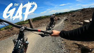
SaveA new bike park situated in the Dublin/Wicklow mountain border and just 20 minutes from Dublin city centre.
Uplift Service:
(64 seats) Fleet of four branded Ford Transits equipped with custom made trailers means a speedy lift to the top
Bike Rental:
Twenty-five full suspension Nukeproof 2020 mountain bikes that each come with a full-face helmet, elbow pads and knee pads included in the cost. Sixteen downhill trails ranging in increasing technical difficulty from intermediate to expert (two blue runs, five red runs, five black runs including a pro-line and a tech track, the Dual Slalom race track and one ‘pedal up’ track).
Spring/Summer time slots run 10am to 1pm (3 hours) & 2pm to 5pm Wednesday to Sunday. Please email if you wish to inquire about the Thursday evening spins.
The scenic walking trails are free to use, they lead to Ticknock and the Dublin and Wicklow Mountain Way. They start at the GAP kitchen (Run by Gary Eustace & crew) with burgers so succulent you would have to see to believe.
Along the route is the ancient ‘Giant’s Grave’, a 4000-year megalithic wedge tomb that is said to be the most intact of its kind.
Please see bike park pricing below…
The Gap is a growing project, be sure to follow us on social media and keep up to date with the parks new features & advancements.
source: The GAP
Primary Trail Type: All-Mountain & Downhill
eBikes Allowed:
Yes
Shuttleable: YES
AKA: GLENCULLEN ADVENTURE PARK
Land Status: Private Property
 google parking directions
This region uses the Uk/Euro style trail grading system.
Activities Click to view
- Mountain Bike
53 trails
- E-Bike
35 trails
- Hike
15 trails
- Trail Running
15 trails
Bike Park Details
- 4
- 4
- 6
- 11
- 17
Region Status
Open as of 2 days- Day Ticket
- €34 EUR
- Uplift Type
- Shuttle
Stats
- Avg Trail Rating
- Trails (view details)
- 42
- Trails Mountain Bike
- 53
- Trails E-Bike
- 35
- Trails Hike
- 15
- Trails Trail Running
- 15
- Total Distance
- 10 miles
- Total Descent Distance
- 6 miles
- Total Descent
- 3,170 ft
- Total Vertical
- 526 ft
- Highest Trailhead
- 1,482 ft
- Reports
- 559
- Photos
- 39
- Ridden Counter
- 17,256
Popular The GAP Mountain Biking Trails
• 85 ★ 4.4 • 883 ft • 0 ft • 679 •
Popular blue difficulty singletrack. This mountain bike primary trail can be used downhill only. It features jump, pump track and roller coaster. Trail visibility is always easy to follow. On average it takes 2 minutes to complete this trail.
• 65 ★ 4.9 • 4,406 ft • 3 ft • 664 •
One of the blue trail in the Gap perfect for novice riders and kids. If you go fast there are several small doubles and tricky berms.
• 60 ★ 4.8 • 1,302 ft • 3 ft • 615 •
Highly rated moderately popular red difficulty singletrack. This mountain bike primary trail can be used downhill only and has a moderate overall physical rating with a 3 ft black diamond climb. It features berm, drop, jump, pump track and roller coaster. Trail visibility is always easy to follow. On average it takes 1 minutes to complete this trail.
• 35 ★ 4.7 • 2,385 ft • 0 ft • 579 •
Highly rated less popular blue difficulty singletrack. This mountain bike primary trail can be used downhill only. It features jump. On average it takes 2 minutes to complete this trail.
• 100 ★ 4.0 • 807 ft • 20 ft • 573 •
Popular green difficulty singletrack. This mountain bike primary trail can be used both directions and has a easy overall physical rating with a 20 ft green climb. Trail visibility is always easy to follow. On average it takes 1 minutes to complete this trail.
• 25 ★ 4.8 • 1,365 ft • 0 ft • 573 •
Highly rated less popular red difficulty singletrack. This mountain bike primary trail can be used downhill only. It features berm, drop and jump. On average it takes 1 minutes to complete this trail.
• 45 ★ 4.8 • 1,112 ft • 0 ft • 552 •
One of the fastest trails in the Gap bikepark, recently revamped so is easy to overshoot the jumps. Fun and fast.
The GAP Mountain Bike Routes
3,428 ft • 4 • Point to Point • Race •
Race track used for the IDMS2022 in The Gap
2 miles • 442 ft • 10 • Race •
Route for 2024 MAD Club Champs Stage 1: + Sacred Stone Link Stage 2: Plus + Pro Line Stage 3:
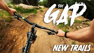
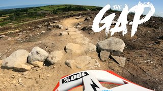
Photos of The GAP Mountain Bike
Videos of The GAP Mountain Bike
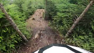
trail: Lucozade
0:43 |
41 |
Dec 14, 2025 , Dublin
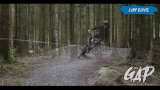
trail: Easy Rider
0:41 |
35 |
Dec 14, 2025 , Dublin
17:33 |
242 |
Nov 14, 2023
7:39 |
280 |
Jul 27, 2021
8:43 |
459 |
Jul 27, 2021
Recent Trail Reports
| status | trail | date | condition | info | user |
|---|---|---|---|---|---|
| Black (GAP skillspark) | Jun 27, 2026 @ 11:13am (Europe/Dublin) 2 days | Unknown | slundy99 | ||
| Dual Slalom | Jun 27, 2026 @ 11:13am (Europe/Dublin) 2 days | Unknown | slundy99 | ||
| Many Shades of Red | Jun 17, 2026 @ 8:26pm (Europe/Dublin) Jun 17, 2026 | Ideal | martyire | ||
| 3 in 1 | Jun 17, 2026 @ 8:26pm (Europe/Dublin) Jun 17, 2026 | Ideal | martyire | ||
| Tree Hugger | Jun 17, 2026 @ 8:26pm (Europe/Dublin) Jun 17, 2026 | Ideal | martyire | ||
| Connector Stitches | Jun 17, 2026 @ 8:26pm (Europe/Dublin) Jun 17, 2026 | Ideal | martyire | ||
| Pedal Up Connector High Area | Jun 17, 2026 @ 8:26pm (Europe/Dublin) Jun 17, 2026 | Ideal | martyire | ||
| Uplift Higher Area | Jun 17, 2026 @ 8:26pm (Europe/Dublin) Jun 17, 2026 | Ideal | martyire | ||
| Death Grip Connector | Jun 17, 2026 @ 8:26pm (Europe/Dublin) Jun 17, 2026 | Ideal | martyire | ||
| Pedal Up Higher Area (steep) | Jun 17, 2026 @ 8:26pm (Europe/Dublin) Jun 17, 2026 | Ideal | martyire |
Activity Feed
| username | action | type | title | date |
|---|---|---|---|---|
| slundy99 | add | report | activity #97933581 and 1 more | Jun 27, 2026 @ 1:36pm 1 day |
| martyire | add | report | activity #97202882 and 9 more | Jun 17, 2026 @ 12:26pm Jun 17, 2026 |
| tra1lerparker | wishlist | trail | activity #97064643 | Jun 15, 2026 @ 2:08pm Jun 15, 2026 |
| martyire | add | trail | activity #95587123 and 1 more | May 26, 2026 @ 1:32pm May 26, 2026 |
| elyari | update | trail | activity #95587102 | May 26, 2026 @ 1:31pm May 26, 2026 |
Recent Comments
| username | type | title | comment | date |
|---|---|---|---|---|
| report | It ain't never coming back. Well not anytime... | May 24, 2026 @ 3:59pm May 24, 2026 | ||
| trail | Fun but loads of small brake bumps | Dec 13, 2021 @ 3:00pm Dec 13, 2021 | ||
| trail | It’s feckin humongous | Nov 13, 2021 @ 2:51pm Nov 13, 2021 | ||
| report | trail all clear and reopened. Quite dry. | Apr 26, 2021 @ 3:47am Apr 26, 2021 | ||
| trail | Its called tech track really steep | Nov 28, 2020 @ 7:02am Nov 28, 2020 |
Nearby Areas
| name | distance | ||||
|---|---|---|---|---|---|
| Stepaside village | 1 | 1.6 km | |||
| Ticknock | 17 | 18 | 3 | 1.7 km | |
| Tibradden Woods | 4 | 13 | 2 km | ||
| Curtlestown | 1 | 16 | 2.1 km | ||
| Barnaslingan Wood | 2 | 1 | 2.2 km |
Local Badges
-

Completionist63 awarded
Bike & Skill Parks
| name | type | city | rating |
|---|---|---|---|
| GAP Skillpark | skill park | Dublin |
Activity Type Stats
| activitytype | trails | distance | descent | descent distance | total vertical | rating | global rank | state rank | photos | reports | routes | ridelogs |
|---|---|---|---|---|---|---|---|---|---|---|---|---|
| Mountain Bike | 53 | 10 miles | 3,169 ft | 6 miles | 525 ft | #203 | #2 | 39 | 559 | 2 | 2,887 | |
| E-Bike | 35 | 5 miles | 1,870 ft | 3 miles | 525 ft | #759 | #7 | 496 | 371 | |||
| Hike | 15 | 5 miles | 1,030 ft | 3 miles | 371 ft | #1,807 | #13 | 536 | 30 | |||
| Trail Running | 15 | 5 miles | 1,030 ft | 3 miles | 371 ft | #1,127 | #13 | 536 | 26 |
Frequently Asked Questions About The GAP
▼
What are the highest rated mountain biking trails in The GAP?
The highest rated mountain biking trails in The GAP are:
- Tickety Boo (4.5/5)
- Witches Cauldron (4.5/5)
- Byrner (4.5/5)
- Sacred Stones (4.5/5)
- Easy Rider (4.4/5)
▼
What is the best time of the year to ride in The GAP?
Based on ride log data, the most popular months to ride in The GAP are:
- October (10 activities)
- April (10 activities)
- January (9 activities)
▼
Where can I park to ride in The GAP?
There are 2 parking locations listed in The GAP. The most popular parking spots are:
▼
What is the longest trail in The GAP?
The longest trail in The GAP is Tickety Boo at 1.3 km. View all trails sorted by distance.
Activities
- By elyari
 TRAILFORKS TFSPAIN & contributors
 - Admins: apply
- #41460 - 9,792 views
- the gap activity log | embed map of The GAP mountain bike trails | the gap mountain biking points of interest
Downloading of trail gps tracks in kml & gpx formats is enabled for The GAP.
You must login to download files.