close
-
Layers w
- Weather Layers
- Pro
- Pro
- Pro
- Pro
- Pro
- Pro
- More Layers
- Pro
- Pro
- Pro
- Pro
-
Upgrade to

3D
Trail Conditions
- Unknown
- Snow Groomed
- Snow Packed
- Snow Covered
- Snow Cover Partial
- Freeze/thaw Cycle
- Icy
- Prevalent Mud
- Wet
- Variable
- Ideal
- Dry
- Very Dry
Trail Flow (Ridden Direction)
Trailforks scans users ridelogs to determine the most popular direction each trail is ridden. A good flowing trail network will have most trails flowing in a single direction according to their intension.
The colour categories are based on what percentage of riders are riding a trail in its intended direction.
The colour categories are based on what percentage of riders are riding a trail in its intended direction.
- > 96%
- > 90%
- > 80%
- > 70%
- > 50%
- < 50%
- bi-directional trail
- no data
Trail Last Ridden
Trailforks scans ridelogs to determine the last time a trail was ridden.
- < 2 days
- < 1 week
- < 2 weeks
- < 1 month
- < 6 months
- > 6 months
Trail Ridden Direction
The intended direction a trail should be ridden.
- Downhill Only
- Downhill Primary
- Both Directions
- Uphill Primary
- Uphill Only
- One Direction
Contribute Details
Colors indicate trail is missing specified detail.
- Description
- Photos
- Description & Photos
- Videos
Trail Popularity ?
Trailforks scans ridelogs to determine which trails are ridden the most in the last 9 months.
Trails are compared with nearby trails in the same city region with a possible 25 colour shades.
Think of this as a heatmap, more rides = more kinetic energy = warmer colors.
- most popular
- popular
- less popular
- not popular
ATV/ORV/OHV Filter
Max Vehicle Width
inches
US Cell Coverage
Legend

Radar Time
Activity Recordings
Trailforks uses anonymized public activity data.
?
Activity Recordings
Trailforks uses anonymized public activity data.
?
Personal Heatmap
▶
Activity Types
all
/
none
▶
Options
2
Date range
month
–
Winter Trails
Warning
A routing network for winter maps does not exist. Selecting trails using the winter trails layer has been disabled.
Missing Trails
Most Popular
Least Popular
Trails are colored based on popularity. The more popular a trail is, the more red. Less popular trails trend towards green.
Jump Magnitude Heatmap
Heatmap of where riders jump on trails. Zoom in to see individual jumps, click circles to view jump details.
BC Backroad Status
![map legend]()
Service Road Atlas is a free to use, community-driven service for viewing and creating reports on the numerous back-country service roads around B.C. and Alberta.

Slope Aspect
Direction the slope faces
Trails Deemphasized
Trails are shown in grey.
Only show trails with no bike usage.
Suggested Layers
Based on selected activity type
Save the current map location and zoom level as your default home location whenever this page is loaded.
Save
No description for Thessalia has been added yet!
Login or register to submit one.
AKA: Thessaly
Region Details
- 2
- 12
- 28
- 2
Stats
- Avg Trail Rating
- Trails (view details)
- 44
- Trails Mountain Bike
- 46
- Trails E-Bike
- 39
- Trails Horse
- 1
- Trails Hike
- 37
- Trails Trail Running
- 37
- Total Distance
- 39 miles
- Total Descent
- 24,326 ft
- Total Vertical
- 4,699 ft
- Highest Trailhead
- 4,729 ft
- Reports
- 98
- Photos
- 248
- Ridden Counter
- 703
Sub Regions
- Magnesia (33)
- South Pelion (7)
- Volos (24)
- Goritsa (8)
- Mount Pelion (11)
- South Pelion (7)
- Trikala Prefecture (13)
Popular Thessalia Mountain Biking Trails
• 100 ★ 5.0 • 3,541 ft • 30 ft • 89 •
wood descending section with switchbacks,small burms,off cambers and great flow.
• 60 ★ 5.0 • 3,701 ft • 214 ft • 77 •
Single track trail with a really nice flow in the first downhill section and an easy climb that gets steep on the last 30 meters.
• ★ 5.0 • 3 miles • 45 ft • 31 •
Awesome singletrack full of berms, drops and rock gardens. Maybe one of the best singletracks of the region. You coul take it from the road.
• 45 ★ 5.0 • 1 mile • 120 ft • 28 •
Fast rolling trail with mixed terrain.Starts as an easy rock garden with some rock faces to ride on,then deeper into the woods with pure dirt and multiple line choises.A fast open section with a big hip jump on the side(optional) in...
• 75 ★ 4.0 • 2 miles • 24 ft • 22 •
Popular blue difficulty singletrack. This mountain bike primary trail can be used both directions. On average it takes 22 minutes to complete this trail.
• 85 ★ 4.7 • 2,096 ft • 0 ft • 19 •
A downhill trail with many features to ride .You can go downhill and from the finish point you can go up again with enduro bike .Best place to practice your fucking skills! Hell yeah !!
• 35 ★ 5.0 • 3,612 ft • 4 ft • 13 •
Less popular green difficulty singletrack. This mountain bike primary trail can be used both directions and has a easy overall physical rating. It features rock garden. Trail visibility is always easy to follow. On average it takes 5 minutes to complete this trail.
Thessalia Mountain Bike Routes
★ 5.0 • 9 miles • 356 ft • 0 • Point to Point •
Mostly singletrack trail From the top of Mountain Pelion to the city of Volos .
★ 5.0 • 8 miles • 56 ft • 0 • Point to Point •
From the top of mountain Pelion to the city (Volos ).One great freeride trail !! 20 minutes from the city !
12 miles • 1,801 ft • 0 •
The route is from the 2017 event and it’s from the first day.
12 miles • 1,234 ft • 0 •
The route is from the 2017 event and the 2nd day of it.
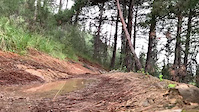
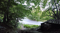
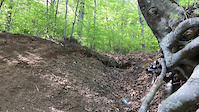
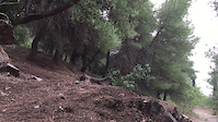
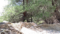
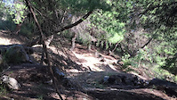
Photos of Thessalia Mountain Bike
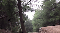
Videos of Thessalia Mountain Bike
trail: Red String
0:14 |
17 |
Dec 26, 2025

0:48 |
8 |
Dec 26, 2025
trail: Chania Downhill Track
0:15 |
8 |
Dec 26, 2025
trail: Chania Downhill Track
0:09 |
14 |
Dec 26, 2025
trail: Koukourava Trail Pt.2
0:10 |
14 |
Dec 26, 2025
trail: Koukourava Trail Pt.2
0:16 |
11 |
Dec 26, 2025
trail: Koukourava Trail Pt.2
0:07 |
8 |
Dec 26, 2025
trail: Koukourava Trail Pt.2
0:07 |
8 |
Dec 26, 2025
Recent Trail Reports
Activity Feed
| username | action | type | title | date |
|---|---|---|---|---|
| konstantinoskaraiskos | comment | report | activity #97185528 | Jun 17, 2026 @ 8:24am 2 days |
| AlexkVHyjM | wishlist | trail | activity #96807197 | Jun 12, 2026 @ 8:42am Jun 12, 2026 |
| VasilgRHHaM | comment | report | activity #96720109 | Jun 10, 2026 @ 11:04pm Jun 10, 2026 |
| blad | comment | report | activity #96250543 | Jun 4, 2026 @ 1:54pm Jun 4, 2026 |
| blad | wishlist | trail | activity #96250133 | Jun 4, 2026 @ 1:47pm Jun 4, 2026 |
Recent Comments
| username | type | title | comment | date |
|---|---|---|---|---|
| report | Hello my friend and sorry for my late reply.... | Jun 17, 2026 @ 8:24am 2 days | ||
| report | Unfortunately most of the trails are affected.... | Jun 10, 2026 @ 11:04pm Jun 10, 2026 | ||
| report | Shame dude had a look at the start on the way... | Jun 4, 2026 @ 1:54pm Jun 4, 2026 | ||
| report | Hey dude travelling up the country from Athens... | May 31, 2026 @ 5:37am May 31, 2026 | ||
| trail | At current date the tracks are covered with... | Dec 26, 2025 @ 8:13am Dec 26, 2025 |
Local Badges
-

10 Blue Trails6 awarded -

Epic Mountain Bike Climb 2k18 awarded -

Climbing 10k Badge3 awarded -

Mountain Biking 100k Badge1 awarded -

Epic Ride Descent 2k18 awarded -

Descent 10k Badge4 awarded
Local Trail Supporters
- meteoraebike.com
- Meteora e-Bike
Activity Type Stats
| activitytype | trails | distance | descent | descent distance | total vertical | rating | global rank | state rank | photos | reports | routes | ridelogs |
|---|---|---|---|---|---|---|---|---|---|---|---|---|
| Mountain Bike | 45 | 39 miles | 24,327 ft | 32 miles | 4,698 ft | 248 | 99 | 4 | 3,749 | |||
| E-Bike | 39 | 34 miles | 20,066 ft | 28 miles | 4,698 ft | 91 | 6 | 133 | ||||
| Horse | 1 | 1 mile | 43 ft | 1,125 ft | 272 ft | 36 | 1 | |||||
| Hike | 37 | 31 miles | 16,729 ft | 25 miles | 4,698 ft | 91 | 3 | 513 | ||||
| Trail Running | 37 | 31 miles | 16,729 ft | 25 miles | 4,698 ft | 91 | 4 | 47 |
Activities
Trails
Points of Interest
- By konstantinoskaraiskos & contributors
- Admins: haristheodoropoulos, mikesf, IMBC
- #11306 - 1,920 views
- thessalia activity log | embed map of Thessalia mountain bike trails | thessalia mountain biking points of interest
Downloading of trail gps tracks in kml & gpx formats is enabled for Thessalia.
You must login to download files.