close
-
Layers w
- Weather Layers
- Pro
- Pro
- Pro
- Pro
- Pro
- Pro
- More Layers
- Pro
- Pro
- Pro
- Pro
-
Upgrade to

3D
Trail Conditions
- Unknown
- Snow Groomed
- Snow Packed
- Snow Covered
- Snow Cover Partial
- Freeze/thaw Cycle
- Icy
- Prevalent Mud
- Wet
- Variable
- Ideal
- Dry
- Very Dry
Trail Flow (Ridden Direction)
Trailforks scans users ridelogs to determine the most popular direction each trail is ridden. A good flowing trail network will have most trails flowing in a single direction according to their intension.
The colour categories are based on what percentage of riders are riding a trail in its intended direction.
The colour categories are based on what percentage of riders are riding a trail in its intended direction.
- > 96%
- > 90%
- > 80%
- > 70%
- > 50%
- < 50%
- bi-directional trail
- no data
Trail Last Ridden
Trailforks scans ridelogs to determine the last time a trail was ridden.
- < 2 days
- < 1 week
- < 2 weeks
- < 1 month
- < 6 months
- > 6 months
Trail Ridden Direction
The intended direction a trail should be ridden.
- Downhill Only
- Downhill Primary
- Both Directions
- Uphill Primary
- Uphill Only
- One Direction
Contribute Details
Colors indicate trail is missing specified detail.
- Description
- Photos
- Description & Photos
- Videos
Trail Popularity ?
Trailforks scans ridelogs to determine which trails are ridden the most in the last 9 months.
Trails are compared with nearby trails in the same city region with a possible 25 colour shades.
Think of this as a heatmap, more rides = more kinetic energy = warmer colors.
- most popular
- popular
- less popular
- not popular
ATV/ORV/OHV Filter
Max Vehicle Width
inches
US Cell Coverage
Legend

Radar Time
Activity Recordings
Trailforks uses anonymized public activity data.
?
Activity Recordings
Trailforks uses anonymized public activity data.
?
Personal Heatmap
▶
Activity Types
all
/
none
▶
Options
2
Date range
month
–
Winter Trails
Warning
A routing network for winter maps does not exist. Selecting trails using the winter trails layer has been disabled.
Missing Trails
Most Popular
Least Popular
Trails are colored based on popularity. The more popular a trail is, the more red. Less popular trails trend towards green.
Jump Magnitude Heatmap
Heatmap of where riders jump on trails. Zoom in to see individual jumps, click circles to view jump details.
BC Backroad Status
![map legend]()
Service Road Atlas is a free to use, community-driven service for viewing and creating reports on the numerous back-country service roads around B.C. and Alberta.

Slope Aspect
Direction the slope faces
Trails Deemphasized
Trails are shown in grey.
Only show trails with no bike usage.
Suggested Layers
Based on selected activity type
Save the current map location and zoom level as your default home location whenever this page is loaded.
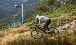
SaveThredbo has held a very special place in Australian mountain bike folklore for over two decades now. Lord knows how many of our most famous downhillers cut their teeth on the legendary Cannonball Run downhill.
But despite its strong history, over the past ten years it had started to become clear that Thredbo’s lustre was fading a little; other alpine resorts were investing heavily in mountain biking and Thredbo was losing ground. Simply having ‘the hill’ was no longer enough. Thankfully, rather than allowing the mountain biking program to slip metaphorically downhill, Thredbo too have launched a program of rejuvenating the mountain bike side of their operations.
But despite its strong history, over the past ten years it had started to become clear that Thredbo’s lustre was fading a little; other alpine resorts were investing heavily in mountain biking and Thredbo was losing ground. Simply having ‘the hill’ was no longer enough. Thankfully, rather than allowing the mountain biking program to slip metaphorically downhill, Thredbo too have launched a program of rejuvenating the mountain bike side of their operations.
Links
Activities Click to view
- Mountain Bike
55 trails
- E-Bike
47 trails
- Gravel Bike
0 trails
- Adaptive Bike
0 trails
- Winter Fat Bike
0 trails
- Hike
37 trails
- Trail Running
36 trails
Region Details
- 4
- 9
- 30
- 1
Region Status
Open as of Jun 8, 2026Stats
- Avg Trail Rating
- Trails (view details)
- 52
- Trails Mountain Bike
- 55
- Trails E-Bike
- 47
- Trails Horse
- 1
- Trails Hike
- 38
- Trails Trail Running
- 36
- Trails Snowshoe
- 3
- Trails Downhill Ski
- 1
- Trails Backcountry Ski
- 3
- Trails Nordic Ski
- 1
- Total Distance
- 205 miles
- Total Descent
- 38,841 ft
- Total Vertical
- 6,435 ft
- Highest Trailhead
- 7,285 ft
- Reports
- 398
- Photos
- 946
- Ridden Counter
- 41,527
Articles
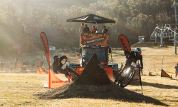
Flow, Speed & Head-to-Head Heat: Day Three at Cannonball MTB Festival in Thredbo
Feb 12, 2026 from pinkbike.com
A full-gas Maxxis Dual Slalom showdown on Friday Flat.
Cannonball MTB Festival Kicks Off In Thredbo
Feb 11, 2026 from pinkbike.com
ith over $120,000 in cash and prizes on offer, the opening day delivered high-intensity racing in near-perfect conditions.

Cannonball Mountain Bike Festival Kicks Off In Thredbo With Epic Racing Conditions
Feb 11, 2025 from pinkbike.com
Recent rainfall is setting the stage for prime riding conditions, and the trails at Thredbo are in amazing shape.
Details Announced for Australian MTB Interschools At Thredbo Resort
Mar 22, 2022 from pinkbike.com
The event has seen a record number of entries with over 1000 students from over 220 schools all ready for five days of exciting gravity mountain...
Sub Regions
-
Kosiuzsko National Park (South)
- 1
-
Lake Crackenback
- 1
- 3
-
Thredbo Bike Park
- 5
- 17
- 1
-
Thredbo Valley Track
- 3
- 5
Popular Thredbo Mountain Biking Trails
• 5 ★ 4.6 • 6 miles • 271 ft • 1,785 •
A family friendly trail from Thredbo to Ngarigo Campground following the beautiful Thredbo River with five spectacular bridges.
• 5 ★ 4.4 • 3 miles • 144 ft • 1,743 •
This is a more technical section of the Thredbo Valley Track, though it is still easily ridden by families with children with some riding experience. A few short steep hills require some effort, but it's certainly worth that effort.
• 5 ★ 4.4 • 2 miles • 143 ft • 1,175 •
This 2.5km section of Thredbo Valley Track is hardened, easy / green circle riding between Thredbo Diggings campground and Bullocks Flat. It is best for families/less experienced riders, though it is a steady (though slight) uphill ride...
• 95 ★ 3.9 • 2 miles • 196 ft • 674 •
Asphalt and gravel roads connecting Thredbo Valley track and Hatchery Bay trail
• 5 ★ 4.5 • 11 miles • 673 ft • 638 •
A 19.7km journey from Bullocks Hut to Gaden Trout Hatchery winding along the beautiful Thredbo River Valley. At the 3.5km point in both directions the track does get more technical with rock gardens, natural features and some sustained...
• 5 ★ 3.7 • 2 miles • 171 ft • 471 •
A more technical option than the Thredbo Valley Track between Thredbo Diggings campground and Lake Crackenback Resort.
• 100 ★ 4.4 • 2 miles • 27 ft • 348 •
Popular blue difficulty family friendly alpine gravel path. This multi-use trail can be used both directions and has a easy overall physical rating with a 27 ft green climb. Trail visibility is always easy to follow. On average it takes 9 minutes to complete this trail.
• 85 ★ 5.0 • 1 mile • 88 ft • 343 •
Popular blue difficulty singletrack. This mountain bike primary trail can be used downhill primary. On average it takes 9 minutes to complete this trail.
Thredbo Mountain Bike Routes
5 miles • 207 ft • 4 • Shuttled •
ALL MOUNTAIN TRAIL FROM TOP TO BOTTOM AT THREDBO
4 miles • 143 ft • 4 • Point to Point •
From the top of the Kosciuszko Express chair lift, take the All Mountain Upper trail down to the top of...
16 miles • 2,841 ft • 1 • Point to Point •
Road to Tin hut. could be done as a bike packing trail. big out and back if not
Photos of Thredbo Mountain Bike
Videos of Thredbo Mountain Bike

trail: Cannonball
17:57 |
49 |
Feb 20, 2025
trail: Cannonball
0:18 |
87 |
Dec 3, 2024

trail: Kosciuszko Flow Trail
0:00 |
86 |
Nov 17, 2024
trail: Lower Thredbo Valley Track
0:35 |
142 |
Aug 4, 2023
trail: Kosciuszko Flow Trail
0:18 |
6 |
Aug 4, 2023
0:33 |
82 |
Aug 4, 2023
0:55 |
85 |
Aug 4, 2023
0:52 |
33 |
Aug 4, 2023
Current Trail Warnings
| status | trail | date | condition | user | info |
|---|---|---|---|---|---|
| Woody's | Jun 9, 2026 @ 12:36pm (Australia/Sydney) Jun 8, 2026 | Unknown | ak0047 | Bike Park Closed, See ya in November! | |
| Village Loop | Jun 9, 2026 @ 12:36pm (Australia/Sydney) Jun 8, 2026 | Unknown | ak0047 | Bike Park Closed, See ya in November! | |
| Upper Easy Rider | Jun 9, 2026 @ 12:36pm (Australia/Sydney) Jun 8, 2026 | Unknown | ak0047 | Bike Park Closed, See ya in November! |
Recent Trail Reports
| status | trail | date | condition | info | user |
|---|---|---|---|---|---|
| Ricochet New Entry | Jun 9, 2026 @ 12:35pm (Australia/Sydney) Jun 8, 2026 | Unknown | ak0047 | ||
| Ricochet | Jun 9, 2026 @ 12:35pm (Australia/Sydney) Jun 8, 2026 | Unknown | ak0047 | ||
| Revolver | Jun 9, 2026 @ 12:35pm (Australia/Sydney) Jun 8, 2026 | Unknown | ak0047 | ||
| Pipeline Path | Jun 9, 2026 @ 12:35pm (Australia/Sydney) Jun 8, 2026 | Unknown | ak0047 | ||
| Pegasus | Jun 9, 2026 @ 12:35pm (Australia/Sydney) Jun 8, 2026 | Unknown | ak0047 | ||
| Paparazzi | Jun 9, 2026 @ 12:35pm (Australia/Sydney) Jun 8, 2026 | Unknown | ak0047 | ||
| Panorama | Jun 9, 2026 @ 12:35pm (Australia/Sydney) Jun 8, 2026 | Unknown | ak0047 | ||
| Lower Easy Rider | Jun 9, 2026 @ 12:35pm (Australia/Sydney) Jun 8, 2026 | Unknown | ak0047 | ||
| Kosciuszko Flow Trail | Jun 9, 2026 @ 12:35pm (Australia/Sydney) Jun 8, 2026 | Unknown | ak0047 | ||
| Home Run | Jun 9, 2026 @ 12:35pm (Australia/Sydney) Jun 8, 2026 | Unknown | ak0047 |
Activity Feed
| username | action | type | title | date |
|---|---|---|---|---|
| ak0047 | add | report | activity #96581198 and 23 more | Jun 8, 2026 @ 7:35pm Jun 8, 2026 |
| ak0047 | add | poi | activity #96345437 | Jun 6, 2026 @ 12:06am Jun 6, 2026 |
| jaredmendham | add | photo | activity #96331698 | Jun 5, 2026 @ 5:17pm Jun 5, 2026 |
| jaredmendham | add | photo | activity #96331663 and 3 more | Jun 5, 2026 @ 5:16pm Jun 5, 2026 |
| qua3000 | ridden | trail | activity #95907014 | May 30, 2026 @ 8:06pm May 30, 2026 |
Recent Comments
| username | type | title | comment | date |
|---|---|---|---|---|
| report | Fire danger in snowy mountains? | Apr 14, 2026 @ 12:23am Apr 14, 2026 | ||
| trail | Tabletop jumps and berms. Trust the berms and... | Mar 31, 2026 @ 5:56pm Mar 31, 2026 | ||
| trail | This trail has been closed for 2 years | Mar 31, 2026 @ 5:53pm Mar 31, 2026 | ||
| trail | Flow Link was probably one of my favourite... | Mar 13, 2026 @ 12:16am Mar 13, 2026 | ||
| trail | Revolver is a fun little A-Line off the... | Mar 13, 2026 @ 12:11am Mar 13, 2026 |
Local Badges
-

10 Blue Trails1,045 awarded -

Epic Ride Climb 2k1,781 awarded -

Climbing 10k Badge339 awarded -

Climbing 100k Badge7 awarded -

Epic Ride Descent 2k4,879 awarded -

Descent 10k Badge686 awarded
Bike & Skill Parks
| name | type | city | rating |
|---|---|---|---|
| Thredbo Bike Park | bike park | Thredbo | |
| Valley Terminal Jumps Zone | skill park | Thredbo | |
| Thredbo Beginner Skillpark | skill park | Thredbo | |
| Pump Track | skill park | Thredbo |
Activity Type Stats
| activitytype | trails | distance | descent | descent distance | total vertical | rating | global rank | state rank | photos | reports | routes | ridelogs |
|---|---|---|---|---|---|---|---|---|---|---|---|---|
| Mountain Bike | 55 | 136 miles | 26,276 ft | 76 miles | 6,142 ft | #537 | #28 | 918 | 398 | 8 | 32,787 | |
| E-Bike | 47 | 111 miles | 22,589 ft | 63 miles | 6,142 ft | #274 | #38 | 3 | 368 | 2 | 2,247 | |
| Horse | 1 | 15 miles | 1,578 ft | 8 miles | 1,198 ft | 57 | 1 | |||||
| Hike | 37 | 184 miles | 29,967 ft | 94 miles | 6,434 ft | #289 | #13 | 12 | 368 | 1 | 1,399 | |
| Trail Running | 36 | 177 miles | 28,540 ft | 92 miles | 6,316 ft | #685 | #22 | 368 | 6 | 469 | ||
| Snowshoe | 3 | 2 | 4 | 29 | ||||||||
| Downhill Ski | 1 | 13 | 4 | 1,651 | ||||||||
| Backcountry Ski | 3 | 4 | 249 | |||||||||
| Nordic Ski | 1 | 4 | 50 |
Frequently Asked Questions About Thredbo
▼
What are the best places to ride in Thredbo?
Thredbo has 4 areas to explore for mountain biking. The top rated areas are:
▼
What are the highest rated mountain biking trails in Thredbo?
The highest rated mountain biking trails in Thredbo are:
- Cannonball (4.6/5)
- Kosciuszko Flow Trail (4.6/5)
- Grasshopper (4.4/5)
- Flow Link (4.4/5)
- Ricochet (4.4/5)
▼
What is the best time of the year to ride in Thredbo?
Based on ride log data, the most popular months to ride in Thredbo are:
- January (343 activities)
- December (308 activities)
- February (194 activities)
▼
Where can I park to ride in Thredbo?
There are 3 parking locations listed in Thredbo. The most popular parking spots are: View all parking and trailhead locations on the map to plan your visit.
Activities
Trails
Points of Interest
- By TomWalpole & contributors
- Admins: stuartrichardson
- #7476 - 12,733 views
- thredbo activity log | embed map of Thredbo mountain bike trails | thredbo mountain biking points of interest
Downloading of trail gps tracks in kml & gpx formats is enabled for Thredbo.
You must login to download files.