close
-
Layers w
- Weather Layers
- Pro
- Pro
- Pro
- Pro
- Pro
- Pro
- More Layers
- Pro
- Pro
- Pro
- Pro
-
Upgrade to

3D
Trail Conditions
- Unknown
- Snow Groomed
- Snow Packed
- Snow Covered
- Snow Cover Partial
- Freeze/thaw Cycle
- Icy
- Prevalent Mud
- Wet
- Variable
- Ideal
- Dry
- Very Dry
Trail Flow (Ridden Direction)
Trailforks scans users ridelogs to determine the most popular direction each trail is ridden. A good flowing trail network will have most trails flowing in a single direction according to their intension.
The colour categories are based on what percentage of riders are riding a trail in its intended direction.
The colour categories are based on what percentage of riders are riding a trail in its intended direction.
- > 96%
- > 90%
- > 80%
- > 70%
- > 50%
- < 50%
- bi-directional trail
- no data
Trail Last Ridden
Trailforks scans ridelogs to determine the last time a trail was ridden.
- < 2 days
- < 1 week
- < 2 weeks
- < 1 month
- < 6 months
- > 6 months
Trail Ridden Direction
The intended direction a trail should be ridden.
- Downhill Only
- Downhill Primary
- Both Directions
- Uphill Primary
- Uphill Only
- One Direction
Contribute Details
Colors indicate trail is missing specified detail.
- Description
- Photos
- Description & Photos
- Videos
Trail Popularity ?
Trailforks scans ridelogs to determine which trails are ridden the most in the last 9 months.
Trails are compared with nearby trails in the same city region with a possible 25 colour shades.
Think of this as a heatmap, more rides = more kinetic energy = warmer colors.
- most popular
- popular
- less popular
- not popular
ATV/ORV/OHV Filter
Max Vehicle Width
inches
US Cell Coverage
Legend

Radar Time
Activity Recordings
Trailforks uses anonymized public activity data.
?
Activity Recordings
Trailforks uses anonymized public activity data.
?
Personal Heatmap
▶
Activity Types
all
/
none
▶
Options
2
Date range
month
–
Winter Trails
Warning
A routing network for winter maps does not exist. Selecting trails using the winter trails layer has been disabled.
Missing Trails
Most Popular
Least Popular
Trails are colored based on popularity. The more popular a trail is, the more red. Less popular trails trend towards green.
Jump Magnitude Heatmap
Heatmap of where riders jump on trails. Zoom in to see individual jumps, click circles to view jump details.
BC Backroad Status
![map legend]()
Service Road Atlas is a free to use, community-driven service for viewing and creating reports on the numerous back-country service roads around B.C. and Alberta.

Slope Aspect
Direction the slope faces
Trails Deemphasized
Trails are shown in grey.
Only show trails with no bike usage.
Suggested Layers
Based on selected activity type
Save the current map location and zoom level as your default home location whenever this page is loaded.
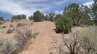
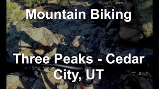
SaveThe Three Peaks Trail System near Cedar City offers a well-rounded mountain biking experience: easy loops to warm up, mid-length singletrack with climbs and descents, and fun technical features that make each loop enjoyable. It’s a great choice for intermediate riders, but also welcoming to beginners who want to expand their skills and experienced riders looking for classic desert cross-country riding.
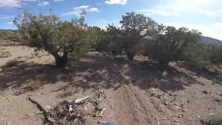
Three Peaks is a great place to spend the afternoon exploring. It accommodates all riders. The main parking lot is surrounding with easy trails that are smooth buttery singletrack, a little sandy in places, but pretty easy riding. A few little bridge wash crossings and optional rocky or rooty lines, but great place for new riders, kids and scout groups to get some single track miles in.
To the south are a Whale Trails, which are difficult to navigate and require some good skill on the bike. Miles come really slow here, not great for getting in MTB merit badge mileage or XC training.
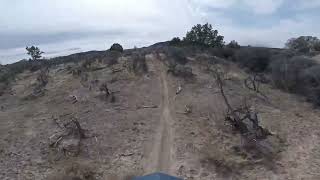
The big loop is great for the intermediate to advanced rider to get some serious XC miles and have fun with some technical areas and stiff climbs to train those legs for your next race.
The Three Peaks Trail System is part of the broader Three Peaks Recreation Area, a 6,000+-acre outdoor playground managed by the Bureau of Land Management (BLM) about 10 miles northwest of Cedar City. Within this area, the Three Peaks Non-Motorized Trail System includes over ~30 miles of designated mountain bike trails ranging from easy practice loops to longer intermediate/advanced loops.
♂️ Trail Types & Riding Experience
Beginner & Warm-Up Trails
Practice Loop: A short, accessible loop right at the trailhead — perfect for beginners or as a warm-up before heading onto longer rides.
Intermediate Options
Race Loop: A classic intermediate singletrack route with a balance of climbing, fast sections, and some technical bits that keep the ride engaging for riders with some experience.
Big Hole Loop & Three Peaks Loop: Longer cross-country loops that introduce more distance, rolling hills, moderate climbs, and variable terrain — ideal for riders looking for a solid half-day ride.
⚫ Upper-Intermediate & Technical Options
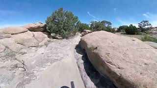
The overall network connects a web of trails such as Lost World, Petrified Whales, Jumbled Jonah, Moby Dick, and Twilight Zone, which add technical terrain, slickrock sections, short climbs, and features like ladder bridges. These segments let more experienced riders explore fun and varied terrain beyond the main loops.
️ Terrain & Style
Cross-country focus: Riding at Three Peaks is more cross-country and mixed-terrain than pure downhill. You’ll pedal moderate climbs, cruise through rolling singletrack, and navigate slickrock, decomposed granite, and desert soil.
Scenic desert vibe: Expect panoramic views of granite outcroppings, juniper and pinion pine, and open high-desert terrain — all with the classic red/gray rock character of southern Utah.
Technical features: Ladder bridges and small technical sections add fun challenges without being overly extreme — ride-around options are common.
♀️ Ride Planning Tips
Versatile routes: You can piece together 5–15 mile rides (or longer) by linking Practice Loop, Race Loop, Three Peaks Loop, and connectors like Lost World or Outlaw.
Skill progression: Beginners can stick to Practice Loop and easy sections, while stronger riders can explore longer loops and technical connectors.
Multi-use area: Although the biking trails are non-motorized, Three Peaks Recreation Area also has OHV, equestrian, hiking, and disc-golf areas — so be mindful of shared spaces off the MTB trails.
Best time of year: Trail conditions are typically best spring through fall — winter may see snow/icy patches.
Three Peaks is a great place to spend the afternoon exploring. It accommodates all riders. The main parking lot is surrounding with easy trails that are smooth buttery singletrack, a little sandy in places, but pretty easy riding. A few little bridge wash crossings and optional rocky or rooty lines, but great place for new riders, kids and scout groups to get some single track miles in.
To the south are a Whale Trails, which are difficult to navigate and require some good skill on the bike. Miles come really slow here, not great for getting in MTB merit badge mileage or XC training.
The big loop is great for the intermediate to advanced rider to get some serious XC miles and have fun with some technical areas and stiff climbs to train those legs for your next race.
The Three Peaks Trail System is part of the broader Three Peaks Recreation Area, a 6,000+-acre outdoor playground managed by the Bureau of Land Management (BLM) about 10 miles northwest of Cedar City. Within this area, the Three Peaks Non-Motorized Trail System includes over ~30 miles of designated mountain bike trails ranging from easy practice loops to longer intermediate/advanced loops.
♂️ Trail Types & Riding Experience
Beginner & Warm-Up Trails
Practice Loop: A short, accessible loop right at the trailhead — perfect for beginners or as a warm-up before heading onto longer rides.
Intermediate Options
Race Loop: A classic intermediate singletrack route with a balance of climbing, fast sections, and some technical bits that keep the ride engaging for riders with some experience.
Big Hole Loop & Three Peaks Loop: Longer cross-country loops that introduce more distance, rolling hills, moderate climbs, and variable terrain — ideal for riders looking for a solid half-day ride.
⚫ Upper-Intermediate & Technical Options
The overall network connects a web of trails such as Lost World, Petrified Whales, Jumbled Jonah, Moby Dick, and Twilight Zone, which add technical terrain, slickrock sections, short climbs, and features like ladder bridges. These segments let more experienced riders explore fun and varied terrain beyond the main loops.
️ Terrain & Style
Cross-country focus: Riding at Three Peaks is more cross-country and mixed-terrain than pure downhill. You’ll pedal moderate climbs, cruise through rolling singletrack, and navigate slickrock, decomposed granite, and desert soil.
Scenic desert vibe: Expect panoramic views of granite outcroppings, juniper and pinion pine, and open high-desert terrain — all with the classic red/gray rock character of southern Utah.
Technical features: Ladder bridges and small technical sections add fun challenges without being overly extreme — ride-around options are common.
♀️ Ride Planning Tips
Versatile routes: You can piece together 5–15 mile rides (or longer) by linking Practice Loop, Race Loop, Three Peaks Loop, and connectors like Lost World or Outlaw.
Skill progression: Beginners can stick to Practice Loop and easy sections, while stronger riders can explore longer loops and technical connectors.
Multi-use area: Although the biking trails are non-motorized, Three Peaks Recreation Area also has OHV, equestrian, hiking, and disc-golf areas — so be mindful of shared spaces off the MTB trails.
Best time of year: Trail conditions are typically best spring through fall — winter may see snow/icy patches.
 google parking directions
 Access Info:
Trailhead & Facilities
Three Peaks Mountain Bike Trailhead: A well-equipped starting point with parking, potable water, a vault toilet, a covered picnic area, bike repair stand, and informational kiosk.
The trailhead sits at the edge of the recreation area and gives immediate access to the non-motorized trail network.
Three Peaks Mountain Bike Trailhead: A well-equipped starting point with parking, potable water, a vault toilet, a covered picnic area, bike repair stand, and informational kiosk.
The trailhead sits at the edge of the recreation area and gives immediate access to the non-motorized trail network.
Activities Click to view
- Mountain Bike
52 trails
- E-Bike
4 trails
- Hike
48 trails
- Trail Running
48 trails
Region Details
- 13
- 9
- 17
- 5
Region Status
Open as of Jun 16, 2026Stats
- Avg Trail Rating
- Trails (view details)
- 44
- Trails Mountain Bike
- 52
- Trails E-Bike
- 4
- Trails Hike
- 48
- Trails Trail Running
- 48
- Trails Dirtbike/Moto
- 2
- Trails ATV/ORV/OHV
- 2
- Total Distance
- 50 miles
- Total Descent
- 5,845 ft
- Total Vertical
- 765 ft
- Highest Trailhead
- 6,169 ft
- Reports
- 863
- Photos
- 226
- Ridden Counter
- 14,350
Popular Three Peaks Trail System Mountain Biking Trails
• 100 ★ 4.8 • 3,780 ft • 10 ft • 1,136 •
Fun trail to drop off the Loop. Fast and flows at the beginning, then drops you into some sand stone transitions and even a bit of a rock drop. A rollercoaster and a couple optional rocky lines to make it interesting.
• 95 ★ 3.8 • 2 miles • 108 ft • 764 •
Easy and smooth, with some small berms and a couple optional bridges. Good place to practice for kids and beginners.
• 80 ★ 4.4 • 3 miles • 271 ft • 697 •
A new trail for 2016 starting just off the . This trail heads southwest towards the Rocky Peak Trailhead and campground. It consists of lots of sandstone rock features, with a few unique wooden ladder bridges that are integrated into...
• 65 ★ 5.0 • 2,562 ft • 4 ft • 680 •
Fun little trail connecting and the . Very mellow.
• 85 ★ 4.5 • 853 ft • 0 ft • 669 •
Popular blue difficulty singletrack. This mountain bike primary trail. On average it takes 1 minutes to complete this trail.
• 60 ★ 3.6 • 4,541 ft • 211 ft • 567 •
This trail is an access to/from the (a portion was closed in 2024 at request of private property owner). It has some chattery loose sections but nothing unmanageable. It a cross country trail with no extreme up or down sections. There...
• 85 ★ 3.0 • 4,708 ft • 52 ft • 545 •
This is labeled as difficult, but it really is not. It follows close to the ATV track that is labeled the Race Loop. Definitely more fun to ride then the Race Loop section here, but fairly not-descript connector to the Loop or Loop
• 70 ★ 3.9 • 4,367 ft • 0 ft • 533 •
Northwestern part of the Race Course loop, which includes a few awesome wooden features.
Three Peaks Trail System Mountain Bike Routes
★ 5.0 • 6 miles • 510 ft • 1 •
Uploaded GXP file to tailforks for navigation.
★ 4.2 • 11 miles • 841 ft • 14 • Loop •
You want the full experience? Well, take the time and ride this loop. Get ready for some tough climbs and...
10 miles • 874 ft • 2 • Loop •
Fun short 10 mile loop clockwise direction,lots of variety terrain. Starts with some rock crawling into...
★ 4.0 • 17 miles • 1,746 ft • 14 • Loop •
Three Peaks loop of advanced trails.
Photos of Three Peaks Trail System Mountain Bike
Videos of Three Peaks Trail System Mountain Bike

trail: Twilight Zone
0:06 |
32 |
Apr 2, 2025
trail: YES Please
0:08 |
27 |
Jun 22, 2023
trail: Iron Springs Resort
14:31 |
94 |
Mar 23, 2025 , Cedar City
trail: Twilight Zone
14:47 |
93 |
Mar 21, 2025 , Cedar City
trail: YES Please
5:41 |
73 |
Mar 21, 2025 , Cedar City

trail: YES Sir
7:14 |
170 |
May 12, 2023 , Cedar City
trail: Three Peaks
19:23 |
236 |
Aug 19, 2022 , Cedar City

trail: YES Sir
3:25 |
178 |
Apr 1, 2022 , Cedar City
Recent Trail Reports
Activity Feed
| username | action | type | title | date |
|---|---|---|---|---|
| RPS1030 | add | report | activity #97113939 | Jun 16, 2026 @ 8:50am Jun 16, 2026 |
| kowski15 | wishlist | route | activity #97075675 | Jun 15, 2026 @ 5:10pm Jun 15, 2026 |
| bbwolf1123 | add | poi | activity #96240754 and 2 more | Jun 4, 2026 @ 11:10am Jun 4, 2026 |
| bbwolf1123 | add | report | activity #96231200 | Jun 4, 2026 @ 8:50am Jun 4, 2026 |
| bbwolf1123 | add | photo | activity #96230556 and 4 more | Jun 4, 2026 @ 8:41am Jun 4, 2026 |
Recent Comments
| username | type | title | comment | date |
|---|---|---|---|---|
| report | The broken boards have been replaced however... | May 21, 2026 @ 12:11pm May 21, 2026 | ||
| trail | Great trail and a must do addition to the Iron... | Oct 25, 2025 @ 5:58pm Oct 25, 2025 | ||
| trail | This is a great fairy easy trail with a few... | Oct 24, 2025 @ 5:48pm Oct 24, 2025 | ||
| trail | Quite hard to follow in sections but a fun... | Oct 17, 2025 @ 6:09pm Oct 17, 2025 | ||
| trail | The technical fun is limited to a very short... | Aug 4, 2025 @ 12:38pm Aug 4, 2025 |
Nearby Areas
| name | distance | ||||
|---|---|---|---|---|---|
| Iron Springs Resort | 1 | 3 | 1 | 1.8 km | |
| Thunderbird Canyons Trail System | 1 | 10 | 3 | 9.3 km | |
| Iron Hills Trail System | 10 | 9 | 4 | 1 | 10 km |
| Blowhard Trail System | 1 | 18.9 km | |||
| Brian Head Resort | 2 | 11 | 9 | 2 | 19.1 km |
Local Badges
-

Completionist1 awarded
Activity Type Stats
| activitytype | trails | distance | descent | descent distance | total vertical | rating | global rank | state rank | photos | reports | routes | ridelogs |
|---|---|---|---|---|---|---|---|---|---|---|---|---|
| Mountain Bike | 52 | 50 miles | 5,846 ft | 26 miles | 764 ft | #1,396 | #478 | 229 | 863 | 16 | 9,916 | |
| E-Bike | 4 | 3 miles | 325 ft | 2 miles | 705 ft | #8,336 | #2,601 | 770 | 1 | 416 | ||
| Hike | 48 | 46 miles | 4,820 ft | 23 miles | 764 ft | #4,897 | #1,771 | 859 | 181 | |||
| Trail Running | 48 | 46 miles | 4,820 ft | 23 miles | 764 ft | #3,941 | #1,106 | 859 | 188 | |||
| Dirtbike/Moto | 2 | 1 mile | 7 ft | 518 ft | 407 ft | 283 | 1 | |||||
| ATV/ORV/OHV | 2 | 1 mile | 7 ft | 518 ft | 407 ft | 283 | 4 |
Frequently Asked Questions About Three Peaks Trail System
▼
What are the highest rated mountain biking trails in Three Peaks Trail System?
The highest rated mountain biking trails in Three Peaks Trail System are:
- Lost World (4.5/5)
- Outer Limits (4.4/5)
- Practice Loop (4.3/5)
- YES Please (4.3/5)
- Twilight Zone (4.2/5)
▼
What is the best time of the year to ride in Three Peaks Trail System?
Based on ride log data, the most popular months to ride in Three Peaks Trail System are:
- May (121 activities)
- April (102 activities)
- February (95 activities)
▼
Where can I park to ride in Three Peaks Trail System?
There are 1 parking locations listed in Three Peaks Trail System. The most popular parking spots are:
▼
What is the longest trail in Three Peaks Trail System?
The longest trail in Three Peaks Trail System is Three Peaks at 7.7 km. View all trails sorted by distance.
Activities
Trails
- Hard trails in Three Peaks Trail System
- Easy trails in Three Peaks Trail System
- Favorite trails in Three Peaks Trail System
- Most ridden trails in Three Peaks Trail System
- Singletrack in Three Peaks Trail System
- Viewpoint trails in Three Peaks Trail System
- Trails with technical features in Three Peaks Trail System
- Race routes in Three Peaks Trail System
Points of Interest
- Petrified Whale Wooden Bridge TTF
- Three peaks loop ladder bridge TTF
- Three peaks loop Bridge TTF
- Three peaks loop sand crossing TTF
- Three Peaks Technical Bridge TTF
- Three Peaks loop Downed Tree Bridge TTF
- Three Peaks Loop Wooden Bridge TTF
- Petrified Whales Bridge #2 TTF
- Petrified Whales Bridge River bed Crossing TTF
- Petrified Whales Bridge TTF
- By todd
 Trailforks & contributors
 - Admins: TASU, IronTC, IronTC
- #4861 - 15,311 views
- three peaks trail system activity log | embed map of Three Peaks Trail System mountain bike trails | three peaks trail system mountain biking points of interest
Downloading of trail gps tracks in kml & gpx formats is enabled for Three Peaks Trail System.
You must login to download files.