close
-
Layers w
- Weather Layers
- Pro
- Pro
- Pro
- Pro
- Pro
- Pro
- More Layers
- Pro
- Pro
- Pro
- Pro
-
Upgrade to

3D
Trail Conditions
- Unknown
- Snow Groomed
- Snow Packed
- Snow Covered
- Snow Cover Partial
- Freeze/thaw Cycle
- Icy
- Prevalent Mud
- Wet
- Variable
- Ideal
- Dry
- Very Dry
Trail Flow (Ridden Direction)
Trailforks scans users ridelogs to determine the most popular direction each trail is ridden. A good flowing trail network will have most trails flowing in a single direction according to their intension.
The colour categories are based on what percentage of riders are riding a trail in its intended direction.
The colour categories are based on what percentage of riders are riding a trail in its intended direction.
- > 96%
- > 90%
- > 80%
- > 70%
- > 50%
- < 50%
- bi-directional trail
- no data
Trail Last Ridden
Trailforks scans ridelogs to determine the last time a trail was ridden.
- < 2 days
- < 1 week
- < 2 weeks
- < 1 month
- < 6 months
- > 6 months
Trail Ridden Direction
The intended direction a trail should be ridden.
- Downhill Only
- Downhill Primary
- Both Directions
- Uphill Primary
- Uphill Only
- One Direction
Contribute Details
Colors indicate trail is missing specified detail.
- Description
- Photos
- Description & Photos
- Videos
Trail Popularity ?
Trailforks scans ridelogs to determine which trails are ridden the most in the last 9 months.
Trails are compared with nearby trails in the same city region with a possible 25 colour shades.
Think of this as a heatmap, more rides = more kinetic energy = warmer colors.
- most popular
- popular
- less popular
- not popular
ATV/ORV/OHV Filter
Max Vehicle Width
inches
US Cell Coverage
Legend

Radar Time
Activity Recordings
Trailforks uses anonymized public activity data.
?
Activity Recordings
Trailforks uses anonymized public activity data.
?
Personal Heatmap
▶
Activity Types
all
/
none
▶
Options
2
Date range
month
–
Winter Trails
Warning
A routing network for winter maps does not exist. Selecting trails using the winter trails layer has been disabled.
Missing Trails
Most Popular
Least Popular
Trails are colored based on popularity. The more popular a trail is, the more red. Less popular trails trend towards green.
Jump Magnitude Heatmap
Heatmap of where riders jump on trails. Zoom in to see individual jumps, click circles to view jump details.
BC Backroad Status
![map legend]()
Service Road Atlas is a free to use, community-driven service for viewing and creating reports on the numerous back-country service roads around B.C. and Alberta.

Slope Aspect
Direction the slope faces
Trails Deemphasized
Trails are shown in grey.
Only show trails with no bike usage.
Suggested Layers
Based on selected activity type
Save the current map location and zoom level as your default home location whenever this page is loaded.
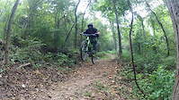
SaveFun, Flow, and Jumps. That is all this place is so far. there is only three trails and two ways to get into this place . 1 trail that gets in you in from one direction and the other way is a cement path that takes you straight to the bottom. This place has many jumps and technical features such as many wallrides, skinnies and big jumps. Also a few drop that pretty decent thrown into the mix.
Primary Trail Type: All-Mountain & Downhill
Land Status: City Managed
 google parking directions
 Access Info:
Get off I 49 travel East on HWY 60(A.K.A. E Wagon Wheel Rd.) until the 2nd stop light where you will turn onto Silent Grove Rd South, from there as your driving south you will go about 1 mile and be looking on your left for W Pump Station Rd. and the parking area is right there . Also right next to the parking lot is a pump track to get warmed up on along with a mini skills area.
Activities Click to view
- Mountain Bike
6 trails
- E-Bike
7 trails
- Hike
7 trails
- Trail Running
7 trails
Region Details
- 1
- 3
- 1
- 1
Region Status
Caution as of Apr 23, 2025Stats
- Avg Trail Rating
- Trails (view details)
- 6
- Trails Mountain Bike
- 8
- Trails E-Bike
- 7
- Trails Hike
- 7
- Trails Trail Running
- 7
- Total Distance
- 5 miles
- Total Descent
- 441 ft
- Total Vertical
- 106 ft
- Highest Trailhead
- 1,301 ft
- Reports
- 67
- Photos
- 15
- Ridden Counter
- 957
Popular Thunder Chicken Mountain Biking Trails
• 50 ★ 4.5 • 1 mile • 56 ft • 146 •
The cement trail that takes you from the parking lot to the trial head about to be expanded to Nature Area
• 10 ★ 4.6 • 1,952 ft • 0 ft • 107 •
The trail that you probably came to this place for. ! All flow, all jumps, all drops, big jumps (at bottom), wallrides. This is awesome for arkansas. A piece of the big mountains that found its way to arkansas. Tips of advice once you...
• 5 ★ 4.0 • 2,753 ft • 88 ft • 104 •
A good trail that you can go either way on but is mainly best for going down. has a wallride and is somewhat a rough trail. The wall ride is fun and easy to ride great for beginners to learn on. somewhat flowy. has some chunky rocks...
• 20 ★ 3.0 • 3,189 ft • 8 ft • 98 •
Fun downhill section that is right beside the main trail but can also be used to get back up to the top it flows boths ways but is definitely better downhill.
• 20 ★ 1.0 • 2,415 ft • 26 ft • 52 •
Less popular green difficulty singletrack. This mountain bike primary trail can be used both directions and has a moderate overall physical rating with a 26 ft blue climb. On average it takes 6 minutes to complete this trail.
• 25 ★ 5.0 • 2,474 ft • 48 ft • 32 •
This is an old road thru the trail network
Photos of Thunder Chicken Mountain Bike
Videos of Thunder Chicken Mountain Bike
trail: Thunder Chicken
2:18 |
1063 |
Aug 29, 2015
Recent Trail Reports
| status | trail | date | condition | info | user |
|---|---|---|---|---|---|
| Thunder Chicken | Apr 23, 2025 @ 4:39pm Apr 23, 2025 | Unknown | Croberts218 | ||
| Valley View | Apr 23, 2025 @ 4:39pm Apr 23, 2025 | Unknown | Croberts218 | ||
| Oak Ridge | Apr 23, 2025 @ 4:39pm Apr 23, 2025 | Unknown | Croberts218 | ||
| Spring Creek Trail | Sep 20, 2023 @ 3:30pm Sep 20, 2023 | Ideal | Randoford | ||
| Prairie Dog | Aug 17, 2019 @ 11:43am Aug 17, 2019 | Dry | blaircartwright |
Activity Feed
| username | action | type | title | date |
|---|---|---|---|---|
| thomcerny | add | photo | activity #89385156 | Feb 22, 2026 @ 2:43pm Feb 22, 2026 |
| jcalvarezjr | wishlist | trail | activity #89370196 | Feb 22, 2026 @ 11:24am Feb 22, 2026 |
| jcalvarezjr | wishlist | trail | activity #89291820 | Feb 21, 2026 @ 10:00am Feb 21, 2026 |
| Neumie | comment | report | activity #73021797 | Jun 3, 2025 @ 2:05pm Jun 3, 2025 |
| Croberts218 | add | report | activity #70255817 and 2 more | Apr 23, 2025 @ 7:39pm Apr 23, 2025 |
Recent Comments
| username | type | title | comment | date |
|---|---|---|---|---|
| report | Can confirm. | Jun 3, 2025 @ 2:05pm Jun 3, 2025 | ||
| trail | There are things being worked on to maybe get... | Jul 25, 2023 @ 10:55am Jul 25, 2023 | ||
| trail | Just went to check it out and it’s... | Jul 24, 2023 @ 8:02pm Jul 24, 2023 | ||
| trail | This trail is a goner, taken back by nature.... | Jun 17, 2023 @ 8:11am Jun 17, 2023 | ||
| trail | Looks like these trails have not been... | Mar 30, 2023 @ 4:27pm Mar 30, 2023 |
Nearby Areas
| name | distance | ||||
|---|---|---|---|---|---|
| Runway Bike Park | 1 | 1 | 1 | 3.2 km | |
| Mount Fitzgerald | 8 | 7 | 2 | 2 | 3.3 km |
| Lake Fayetteville | 2 | 5.6 km | |||
| Wolf Creek Park | 4 | 8.2 km | |||
| Southwest Bentonville | 8.4 km |
Bike & Skill Parks
| name | type | city | rating |
|---|---|---|---|
| Thunder Chicken Skills Park | skill park | Springdale |
Activity Type Stats
| activitytype | trails | distance | descent | descent distance | total vertical | rating | global rank | state rank | photos | reports | routes | ridelogs |
|---|---|---|---|---|---|---|---|---|---|---|---|---|
| Mountain Bike | 6 | 5 miles | 440 ft | 2 miles | 105 ft | #7,066 | #2,695 | 16 | 80 | 1,116 | ||
| E-Bike | 7 | 4 miles | 299 ft | 1 mile | 105 ft | #7,525 | #2,222 | 73 | 18 | |||
| Hike | 7 | 4 miles | 371 ft | 2 miles | 105 ft | #13,806 | #5,959 | 69 | 14 | |||
| Trail Running | 7 | 4 miles | 371 ft | 2 miles | 105 ft | #12,757 | #5,188 | 69 | 36 |
Frequently Asked Questions About Thunder Chicken
▼
What are the highest rated mountain biking trails in Thunder Chicken?
The highest rated mountain biking trails in Thunder Chicken are:
- Thunder Chicken (4.3/5)
- Thunder Chicken CrossRoad (4.1/5)
- Spring Creek Trail (4.1/5)
- Valley View (4/5)
- Leaning Elm (3.7/5)
▼
What is the best time of the year to ride in Thunder Chicken?
Based on ride log data, the most popular months to ride in Thunder Chicken are:
- May (17 activities)
- July (15 activities)
- October (9 activities)
▼
Where can I park to ride in Thunder Chicken?
There are 1 parking locations listed in Thunder Chicken. The most popular parking spots are:
▼
What is the longest trail in Thunder Chicken?
The longest trail in Thunder Chicken is Spring Creek Trail at 1.4 miles. View all trails sorted by distance.
Activities
- By Hotrod4989 & contributors
- Admins: apply
- #10249 - 5,489 views
- thunder chicken activity log | embed map of Thunder Chicken mountain bike trails | thunder chicken mountain biking points of interest
Downloading of trail gps tracks in kml & gpx formats is enabled for Thunder Chicken.
You must login to download files.