close
-
Layers w
- Weather Layers
- Pro
- Pro
- Pro
- Pro
- Pro
- Pro
- More Layers
- Pro
- Pro
- Pro
- Pro
-
Upgrade to

3D
Trail Conditions
- Unknown
- Snow Groomed
- Snow Packed
- Snow Covered
- Snow Cover Partial
- Freeze/thaw Cycle
- Icy
- Prevalent Mud
- Wet
- Variable
- Ideal
- Dry
- Very Dry
Trail Flow (Ridden Direction)
Trailforks scans users ridelogs to determine the most popular direction each trail is ridden. A good flowing trail network will have most trails flowing in a single direction according to their intension.
The colour categories are based on what percentage of riders are riding a trail in its intended direction.
The colour categories are based on what percentage of riders are riding a trail in its intended direction.
- > 96%
- > 90%
- > 80%
- > 70%
- > 50%
- < 50%
- bi-directional trail
- no data
Trail Last Ridden
Trailforks scans ridelogs to determine the last time a trail was ridden.
- < 2 days
- < 1 week
- < 2 weeks
- < 1 month
- < 6 months
- > 6 months
Trail Ridden Direction
The intended direction a trail should be ridden.
- Downhill Only
- Downhill Primary
- Both Directions
- Uphill Primary
- Uphill Only
- One Direction
Contribute Details
Colors indicate trail is missing specified detail.
- Description
- Photos
- Description & Photos
- Videos
Trail Popularity ?
Trailforks scans ridelogs to determine which trails are ridden the most in the last 9 months.
Trails are compared with nearby trails in the same city region with a possible 25 colour shades.
Think of this as a heatmap, more rides = more kinetic energy = warmer colors.
- most popular
- popular
- less popular
- not popular
ATV/ORV/OHV Filter
Max Vehicle Width
inches
US Cell Coverage
Legend

Radar Time
Activity Recordings
Trailforks uses anonymized public activity data.
?
Activity Recordings
Trailforks uses anonymized public activity data.
?
Personal Heatmap
▶
Activity Types
all
/
none
▶
Options
2
Date range
month
–
Winter Trails
Warning
A routing network for winter maps does not exist. Selecting trails using the winter trails layer has been disabled.
Missing Trails
Most Popular
Least Popular
Trails are colored based on popularity. The more popular a trail is, the more red. Less popular trails trend towards green.
Jump Magnitude Heatmap
Heatmap of where riders jump on trails. Zoom in to see individual jumps, click circles to view jump details.
BC Backroad Status
![map legend]()
Service Road Atlas is a free to use, community-driven service for viewing and creating reports on the numerous back-country service roads around B.C. and Alberta.

Slope Aspect
Direction the slope faces
Trails Deemphasized
Trails are shown in grey.
Only show trails with no bike usage.
Suggested Layers
Based on selected activity type
Save the current map location and zoom level as your default home location whenever this page is loaded.
Save
No description for Tigard has been added yet!
Login or register to submit one.
Activities Click to view
- Mountain Bike
16 trails
- Adaptive Bike
0 trails
- Hike
20 trails
- Trail Running
20 trails
Region Details
- 1
- 5
- 9
- 2
Region Status
Open as of Jun 7, 2026Local Trail Association
Stats
- Avg Trail Rating
- Trails (view details)
- 16
- Trails Mountain Bike
- 20
- Trails E-Bike
- 1
- Trails Hike
- 20
- Trails Trail Running
- 20
- Total Distance
- 11 miles
- Total Descent
- 619 ft
- Total Vertical
- 503 ft
- Highest Trailhead
- 627 ft
- Reports
- 67
- Photos
- 51
- Ridden Counter
- 869
Sub Regions
-
Bull Mountain Park
- 4
- 5
Popular Tigard Mountain Biking Trails
• 100 ★ 0.0 • 2 miles • 36 ft • 100 •
Popular white difficulty paved path. This mountain bike primary trail can be used both directions. On average it takes 10 minutes to complete this trail.
• 90 ★ 3.0 • 2 miles • 121 ft • 78 •
Popular white difficulty paved path. This mountain bike primary trail can be used both directions. On average it takes 15 minutes to complete this trail.
• 70 ★ 3.0 • 4,039 ft • 14 ft • 52 •
Popular white difficulty paved path. This mountain bike primary trail can be used both directions. On average it takes 6 minutes to complete this trail.
• 75 ★ 3.0 • 486 ft • 0 ft • 28 •
is a downhill trail with berms, small drops, a jump, and a step down at the end of the trail. All features can be rolled over/bypassed. The trail descends approximately 100 ft. Please be considerate by not making too much noise, as this...
• 55 ★ 2.0 • 2,700 ft • 168 ft • 25 •
Trail begins with a rocky double track road, then ascends into a cliff with narrow single track with roots and tight switchbacks
• 60 ★ 2.0 • 4,409 ft • 61 ft • 23 •
Moderately popular white difficulty paved path. This mountain bike primary trail can be used both directions. On average it takes 4 minutes to complete this trail.
• 65 ★ 0.0 • 469 ft • 0 ft • 23 •
Lots of logs to hop over, sharp turns, steep sections.
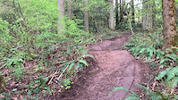
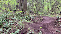
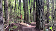
Photos of Tigard Mountain Bike
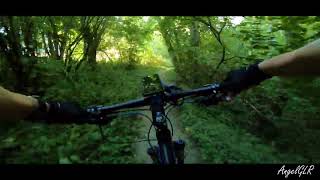
Videos of Tigard Mountain Bike
trail: Dreamcatcher
0:08 |
221 |
May 9, 2022
trail: Dreamcatcher
0:05 |
183 |
May 9, 2022
trail: Dreamcatcher
0:04 |
191 |
May 9, 2022
trail: Pathfinder Genesis Trail
2:08 |
137 |
Aug 12, 2022 , Tigard
Recent Trail Reports
| status | trail | date | condition | info | user |
|---|---|---|---|---|---|
| Defibrilator | Jun 7, 2026 @ 4:28pm (America/Los_Angeles) Jun 7, 2026 | Ideal | WilliamKs6ZJ3 | ||
| Fanno Creek, 105th Ave to Oleson Rd | Nov 18, 2025 @ 1:55pm (America/Vancouver) Nov 18, 2025 | Variable | StevenwyMZrG | ||
| Fanno Creek, Johnson St to Denney Rd | Nov 8, 2025 @ 8:47am (America/Los_Angeles) Nov 8, 2025 | Variable | ckohlmeier | ||
| Forbidden Forest | Nov 8, 2025 @ 8:47am (America/Los_Angeles) Nov 8, 2025 | Wet | ckohlmeier | ||
| Connector Path | Nov 8, 2025 @ 8:47am (America/Los_Angeles) Nov 8, 2025 | Wet | ckohlmeier | ||
| Dreamcatcher | Nov 8, 2025 @ 8:47am (America/Los_Angeles) Nov 8, 2025 | Wet | ckohlmeier | ||
| Bull Mountain Trail 1 | Nov 8, 2025 @ 8:47am (America/Los_Angeles) Nov 8, 2025 | Variable | ckohlmeier | ||
| Bull Mountain Trail 4 | Nov 8, 2025 @ 8:47am (America/Los_Angeles) Nov 8, 2025 | Wet | ckohlmeier | ||
| Pathfinder Genesis Trail | Nov 8, 2025 @ 8:47am (America/Los_Angeles) Nov 8, 2025 | Wet | ckohlmeier | ||
| Pathfinder Genesis Trail Paved Section | Nov 8, 2025 @ 8:47am (America/Los_Angeles) Nov 8, 2025 | Wet | ckohlmeier |
Activity Feed
| username | action | type | title | date |
|---|---|---|---|---|
| WilliamKs6ZJ3 | add | report | activity #96506593 | Jun 7, 2026 @ 4:28pm Jun 7, 2026 |
| WilliamKs6ZJ3 | comment | report | activity #96506307 | Jun 7, 2026 @ 4:24pm Jun 7, 2026 |
| WilliamKs6ZJ3 | add | photo | activity #96505842 and 1 more | Jun 7, 2026 @ 4:17pm Jun 7, 2026 |
| squarep3g12 | add | photo | activity #96505830 and 5 more | Jun 7, 2026 @ 4:17pm Jun 7, 2026 |
| Hwkns2 | wishlist | trail | activity #93916672 | May 2, 2026 @ 8:23pm May 2, 2026 |
Recent Comments
| username | type | title | comment | date |
|---|---|---|---|---|
| report | Yo you probably won’t see this but me and a... | Jun 7, 2026 @ 4:25pm Jun 7, 2026 | ||
| report | Yo you probably won’t see this but me and a... | Jun 7, 2026 @ 4:24pm Jun 7, 2026 | ||
| trail | Has work been done on these trails yet? Or has... | Apr 25, 2026 @ 7:33am Apr 25, 2026 | ||
| trail | Moving here in a month I’ll come dig some. | Jan 24, 2026 @ 6:26pm Jan 24, 2026 | ||
| trail | Just moved here 03/2025 from Az... spent 3... | Apr 17, 2025 @ 10:46pm Apr 17, 2025 |
Local Badges
-

Epic Ride Climb 2k15 awarded -

Climbing 10k Badge24 awarded -

Climbing 100k Badge2 awarded -

Epic Ride Descent 2k15 awarded -

Descent 10k Badge23 awarded -

Descent 100k Badge2 awarded
Activity Type Stats
| activitytype | trails | distance | descent | descent distance | total vertical | rating | global rank | state rank | photos | reports | routes | ridelogs |
|---|---|---|---|---|---|---|---|---|---|---|---|---|
| Mountain Bike | 16 | 11 miles | 620 ft | 3 miles | 502 ft | #8,422 | #2,707 | 46 | 68 | 5,268 | ||
| E-Bike | 1 | 4,177 ft | 121 ft | 4,114 ft | 121 ft | 51 | 373 | |||||
| Hike | 20 | 11 miles | 620 ft | 3 miles | 502 ft | #10,138 | #3,607 | 6 | 69 | 136 | ||
| Trail Running | 20 | 11 miles | 620 ft | 3 miles | 502 ft | #9,238 | #3,110 | 69 | 452 |
Frequently Asked Questions About Tigard
▼
What are the best places to ride in Tigard?
Tigard has 1 areas to explore for mountain biking. The top rated areas are:
▼
What are the highest rated mountain biking trails in Tigard?
The highest rated mountain biking trails in Tigard are:
- Fanno Creek/Colony creek, Grant Ave to Fanno Creek Dr (4/5)
- Fanno Creek, Johnson St to Denney Rd (3.9/5)
- Fanno Creek, 105th Ave to Oleson Rd (3.8/5)
- Dreamcatcher (3.8/5)
- Tigard Street Heritage Trail (3.8/5)
▼
What is the best time of the year to ride in Tigard?
Based on ride log data, the most popular months to ride in Tigard are:
- June (39 activities)
- August (37 activities)
- July (36 activities)
▼
Where can I park to ride in Tigard?
Check the Tigard trail map for trailhead and parking information. Community members regularly update access and parking details for trails in the area.
- By fguerouate & contributors
- Admins: OMBC, chuktA, jmahler
- #29312 - 4,300 views
- tigard activity log | embed map of Tigard mountain bike trails |
Downloading of trail gps tracks in kml & gpx formats is enabled for Tigard.
You must login to download files.