close
-
Layers w
- Weather Layers
- Pro
- Pro
- Pro
- Pro
- Pro
- Pro
- More Layers
- Pro
- Pro
- Pro
- Pro
-
Upgrade to

3D
Trail Conditions
- Unknown
- Snow Groomed
- Snow Packed
- Snow Covered
- Snow Cover Partial
- Freeze/thaw Cycle
- Icy
- Prevalent Mud
- Wet
- Variable
- Ideal
- Dry
- Very Dry
Trail Flow (Ridden Direction)
Trailforks scans users ridelogs to determine the most popular direction each trail is ridden. A good flowing trail network will have most trails flowing in a single direction according to their intension.
The colour categories are based on what percentage of riders are riding a trail in its intended direction.
The colour categories are based on what percentage of riders are riding a trail in its intended direction.
- > 96%
- > 90%
- > 80%
- > 70%
- > 50%
- < 50%
- bi-directional trail
- no data
Trail Last Ridden
Trailforks scans ridelogs to determine the last time a trail was ridden.
- < 2 days
- < 1 week
- < 2 weeks
- < 1 month
- < 6 months
- > 6 months
Trail Ridden Direction
The intended direction a trail should be ridden.
- Downhill Only
- Downhill Primary
- Both Directions
- Uphill Primary
- Uphill Only
- One Direction
Contribute Details
Colors indicate trail is missing specified detail.
- Description
- Photos
- Description & Photos
- Videos
Trail Popularity ?
Trailforks scans ridelogs to determine which trails are ridden the most in the last 9 months.
Trails are compared with nearby trails in the same city region with a possible 25 colour shades.
Think of this as a heatmap, more rides = more kinetic energy = warmer colors.
- most popular
- popular
- less popular
- not popular
ATV/ORV/OHV Filter
Max Vehicle Width
inches
US Cell Coverage
Legend

Radar Time
Activity Recordings
Trailforks uses anonymized public activity data.
?
Activity Recordings
Trailforks uses anonymized public activity data.
?
Personal Heatmap
▶
Activity Types
all
/
none
▶
Options
2
Date range
month
–
Winter Trails
Warning
A routing network for winter maps does not exist. Selecting trails using the winter trails layer has been disabled.
Missing Trails
Most Popular
Least Popular
Trails are colored based on popularity. The more popular a trail is, the more red. Less popular trails trend towards green.
Jump Magnitude Heatmap
Heatmap of where riders jump on trails. Zoom in to see individual jumps, click circles to view jump details.
BC Backroad Status
![map legend]()
Service Road Atlas is a free to use, community-driven service for viewing and creating reports on the numerous back-country service roads around B.C. and Alberta.

Slope Aspect
Direction the slope faces
Trails Deemphasized
Trails are shown in grey.
Only show trails with no bike usage.
Suggested Layers
Based on selected activity type
Save the current map location and zoom level as your default home location whenever this page is loaded.
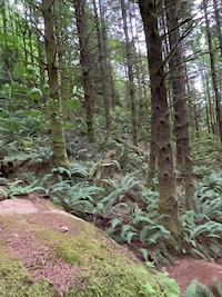
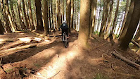
SaveTiger Mountain is one of Seattle's most popular mountain biking destinations. The East Tiger Summit, Preston Railroad Grade, Iverson (Fat Hand), Silent Swamp, Fully Rigid, Joy Ride, Predator, Off-the-Grid, Preston BailOut Radness, The Legend, Master Link, Quick Link, Easy Tiger and Northwest Timber Trails are all open to bicycles. Starting in 2014, trails will not be subject to the past Oct 15 to Apr 15 seasonal closures. However, all trails are still subject to closures depending on trail and weather conditions (check for updates on this page and here). There are many miles of logging roads that are open all year long.
source: Evergreen MTB
Primary Trail Type: All-Mountain & Downhill
eBikes Allowed:
No
Land Status: State Forest
Land Manager: Washington State DNR
 google parking directions
 Region Supporters & Maintainers
Activities Click to view
- Mountain Bike
57 trails
- E-Bike
5 trails
- Hike
142 trails
- Trail Running
142 trails
Region Details
- 18
- 6
- 14
- 7
- 3
Region Status
Open as of Jun 13, 2026Local Trail Association
Stats
- Avg Trail Rating
- Trails (view details)
- 114
- Trails Mountain Bike
- 64
- Trails E-Bike
- 5
- Trails Winter Fat Bike
- 1
- Trails Horse
- 2
- Trails Hike
- 142
- Trails Trail Running
- 142
- Trails Nordic Ski
- 1
- Total Distance
- 125 miles
- Total Descent
- 29,185 ft
- Total Vertical
- 2,818 ft
- Highest Trailhead
- 3,002 ft
- Reports
- 5,809
- Photos
- 1,361
- Ridden Counter
- 110,847
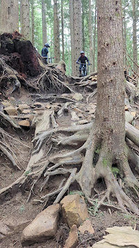
Popular Tiger Mountain State Forest Trails
• 95 ★ 4.6 • 2 miles • 1,026 ft • 6,965 •
The main way to access the upper mountain trails now. This is an uphill-only trail, and is a great option to avoid grinding up the East Summit road. Be alert for hikers on this multi-use trail. Finally climbing singletrack at Tiger, you...
• 90 ★ 2.9 • 1,539 ft • 26 ft • 6,241 •
from upper parking lot to trail, and on to the Trail and road climb. Historically a seasonal closure has been in place from approximately Oct 15 to April 15.
• 95 ★ 4.5 • 2,477 ft • 191 ft • 6,175 •
is an uphill only trail and an alternative to climbing the road. Access it from the end of , or from the Crossover Road.
• 70 ★ 3.5 • 4,783 ft • 38 ft • 4,377 •
A little of everything. Faster and more flowy than , but still enough rocks, roots and switchbacks to keep the tech crowd happy too. Quite rideable uphill (which makes a nice after work loop possible using to to PBR to and back down...
• 85 ★ 4.7 • 2 miles • 24 ft • 4,098 •
Swoopy and fast downhill. Mostly smooth with several roots and rock gardens. Great views of Mt. Rainier and southern Puget Sound from the summit. ETS provides to the tops of several different trails at Tiger. Turn right shortly after...
• 80 ★ 4.5 • 2 miles • 41 ft • 3,887 •
A truly great trail. Catch the start by taking a right at the trail junction off the after it crosses the summit road. Like the other new trails on Tiger, OTG has a bit of everything. It's mostly flowy, but also has its share of tech...
• 70 ★ 3.3 • 1,995 ft • 0 ft • 3,786 •
Gnarly, rocky, rooty goodness, but still has some good flow to it too. Solid single black. The crux, especially when wet, is navigating the "v-tree" root ball about halfway down without dabbing. Ride it twice for a nice extra loop: Ride...
• 85 ★ 4.7 • 2 miles • 3 ft • 3,445 •
NOTE: suffered massive storm damage in November 2024 and closed while crews worked to remove downed trees and reroute trail. After thousands of staff and volunteer hours during the 2024/2025 build season it's now back open, with fresh...
Mountain Bike Routes
★ 4.4 • 10 miles • 1,955 ft • 6 • Loop •
This is the standard Tiger lap from the top. From either parking lot, take the and trails and then the...
★ 3.9 • 13 miles • 2,407 ft • 16 • Loop •
This is a great blue-level loop up to the summit and back for the intermediate rider who's not quite ready...
★ 5.0 • 7 miles • 1,567 ft • 6 • Loop •
Lunch length loop that gets in a couple of good downhills and mostly avoids the service roads.
★ 5.0 • 7 miles • 1,376 ft • 3 •
Fire Road directly to with back to the parking lot.
★ 5.0 • 7 miles • 1,550 ft • 3 •
2022 CDC: Tiger Mt Enduro Lite Course is live The Lite Course will feature the new . The Lite course...
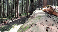
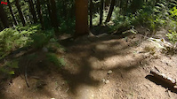
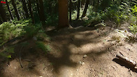
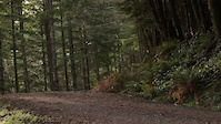
Photos of Tiger Mountain State Forest Mountain Bike
Videos of Tiger Mountain State Forest Mountain Bike
trail: NOTG
0:04 |
138 |
May 12, 2025
0:25 |
|
Aug 30, 2024
0:34 |
51 |
Aug 28, 2024

0:34 |
16 |
Aug 28, 2024
0:18 |
274 |
Feb 13, 2024
0:14 |
121 |
Oct 23, 2023
trail: Close Encounters
0:07 |
415 |
May 30, 2023
0:19 |
539 |
May 22, 2022
Current Trail Warnings
| status | trail | date | condition | user | info |
|---|---|---|---|---|---|
| Secondary Access Road - Raging River Connector | Jun 8, 2026 @ 4:40pm (America/Los_Angeles) Jun 8, 2026 | Unknown | Cmccabe311 | Almost made it to the creek using the... |
Recent Trail Reports
Activity Feed
| username | action | type | title | date |
|---|---|---|---|---|
| BeccaroRMgb | wishlist | route | activity #97505285 | Jun 21, 2026 @ 11:31am 56 mins |
| AdamAlpine | ridden | route | activity #97458357 | Jun 21, 2026 @ 12:04am 12 hours |
| krhae | wishlist | trail | activity #97440697 and 1 more | Jun 20, 2026 @ 4:14pm 20 hours |
| LoamyDaniels | vote | route | activity #97434875 | Jun 20, 2026 @ 2:46pm 22 hours |
| SarahTigBbL | wishlist | route | activity #97416986 | Jun 20, 2026 @ 11:29am 1 day |
Recent Comments
| username | type | title | comment | date |
|---|---|---|---|---|
| trail | First time on Tiger - and this trail is the... | Jun 9, 2026 @ 10:23pm Jun 9, 2026 | ||
| report | Up at the top - drop off Over rock to the... | May 31, 2026 @ 4:42pm May 31, 2026 | ||
| trail | Super fun trail! Heads-up to intermediate... | May 22, 2026 @ 5:15pm May 22, 2026 | ||
| trail | Yes! I love this trail, but calling it blue is... | May 8, 2026 @ 7:02pm May 8, 2026 | ||
| trail | Black bear sighting on way down. | May 8, 2026 @ 6:13am May 8, 2026 |
Nearby Areas
| name | distance | ||||
|---|---|---|---|---|---|
| Taylor Mountain | 11 | 3.6 km | |||
| Snoqualmie Ridge | 6 | 4 km | |||
| Raging River State Forest | 1 | 1 | 4.5 km | ||
| Grand Ridge Park | 13 | 15 | 1 | 5 km | |
| Tennant Trailhead Park | 6 | 6 | 2 | 2 | 6.2 km |
Local Badges
-

Tiger Tamed7 awarded -

Completionist10 awarded
Upcoming Local Events
Local Products
Local Products
Activity Type Stats
| activitytype | trails | distance | descent | descent distance | total vertical | rating | global rank | state rank | photos | reports | routes | ridelogs |
|---|---|---|---|---|---|---|---|---|---|---|---|---|
| Mountain Bike | 57 | 65 miles | 15,856 ft | 33 miles | 2,408 ft | #62 | #25 | 1,378 | 5,824 | 85 | 68,489 | |
| E-Bike | 5 | 11 miles | 2,037 ft | 5 miles | 1,230 ft | #2,463 | #812 | 1 | 3,063 | 11 | 5,210 | |
| Winter Fat Bike | 1 | #38 | #16 | 5 | 3 | |||||||
| Horse | 2 | 2 miles | 174 ft | 2,490 ft | 463 ft | 977 | 4 | |||||
| Hike | 142 | 116 miles | 22,963 ft | 50 miles | 2,818 ft | #83 | #79 | 23 | 4,843 | 14 | 3,691 | |
| Trail Running | 142 | 116 miles | 22,963 ft | 50 miles | 2,818 ft | #303 | #141 | 5 | 4,844 | 13 | 2,432 | |
| Nordic Ski | 1 | 377 ft |
Frequently Asked Questions About Tiger Mountain State Forest
▼
What are the highest rated mountain biking trails in Tiger Mountain State Forest?
The highest rated mountain biking trails in Tiger Mountain State Forest are:
- Predator (MOUNTAIN BIKING ONLY) (4.7/5)
- The Legend (MOUNTAIN BIKING ONLY) (4.6/5)
- NOTG (4.6/5)
- East Tiger Summit (4.6/5)
- Side Hustle (4.6/5)
▼
What is the best time of the year to ride in Tiger Mountain State Forest?
Based on ride log data, the most popular months to ride in Tiger Mountain State Forest are:
- July (1,209 activities)
- August (1,045 activities)
- June (913 activities)
▼
Where can I park to ride in Tiger Mountain State Forest?
There are 4 parking locations listed in Tiger Mountain State Forest. The most popular parking spots are: View all parking and trailhead locations on the map to plan your visit.
▼
What is the longest trail in Tiger Mountain State Forest?
The longest trail in Tiger Mountain State Forest is Preston RR Grade at 3.3 miles. View all trails sorted by distance.
Activities
Trails
- Hard trails in Tiger Mountain State Forest
- Easy trails in Tiger Mountain State Forest
- Favorite trails in Tiger Mountain State Forest
- Most ridden trails in Tiger Mountain State Forest
- Singletrack in Tiger Mountain State Forest
- Viewpoint trails in Tiger Mountain State Forest
- Trails with technical features in Tiger Mountain State Forest
- Race routes in Tiger Mountain State Forest
- By jebike
 & contributors
 - Admins: WA DNR SQD, EMBA-C2S
- #5475 - 248,404 views
- tiger mountain state forest activity log | embed map of Tiger Mountain State Forest mountain bike trails | tiger mountain state forest mountain biking points of interest
Downloading of trail gps tracks in kml & gpx formats is enabled for Tiger Mountain State Forest.
You must login to download files.