close
-
Layers w
- Weather Layers
- Pro
- Pro
- Pro
- Pro
- Pro
- Pro
- More Layers
- Pro
- Pro
- Pro
- Pro
-
Upgrade to

3D
Trail Conditions
- Unknown
- Snow Groomed
- Snow Packed
- Snow Covered
- Snow Cover Partial
- Freeze/thaw Cycle
- Icy
- Prevalent Mud
- Wet
- Variable
- Ideal
- Dry
- Very Dry
Trail Flow (Ridden Direction)
Trailforks scans users ridelogs to determine the most popular direction each trail is ridden. A good flowing trail network will have most trails flowing in a single direction according to their intension.
The colour categories are based on what percentage of riders are riding a trail in its intended direction.
The colour categories are based on what percentage of riders are riding a trail in its intended direction.
- > 96%
- > 90%
- > 80%
- > 70%
- > 50%
- < 50%
- bi-directional trail
- no data
Trail Last Ridden
Trailforks scans ridelogs to determine the last time a trail was ridden.
- < 2 days
- < 1 week
- < 2 weeks
- < 1 month
- < 6 months
- > 6 months
Trail Ridden Direction
The intended direction a trail should be ridden.
- Downhill Only
- Downhill Primary
- Both Directions
- Uphill Primary
- Uphill Only
- One Direction
Contribute Details
Colors indicate trail is missing specified detail.
- Description
- Photos
- Description & Photos
- Videos
Trail Popularity ?
Trailforks scans ridelogs to determine which trails are ridden the most in the last 9 months.
Trails are compared with nearby trails in the same city region with a possible 25 colour shades.
Think of this as a heatmap, more rides = more kinetic energy = warmer colors.
- most popular
- popular
- less popular
- not popular
ATV/ORV/OHV Filter
Max Vehicle Width
inches
US Cell Coverage
Legend

Radar Time
Activity Recordings
Trailforks uses anonymized public activity data.
?
Activity Recordings
Trailforks uses anonymized public activity data.
?
Personal Heatmap
▶
Activity Types
all
/
none
▶
Options
2
Date range
month
–
Winter Trails
Warning
A routing network for winter maps does not exist. Selecting trails using the winter trails layer has been disabled.
Missing Trails
Most Popular
Least Popular
Trails are colored based on popularity. The more popular a trail is, the more red. Less popular trails trend towards green.
Jump Magnitude Heatmap
Heatmap of where riders jump on trails. Zoom in to see individual jumps, click circles to view jump details.
BC Backroad Status
![map legend]()
Service Road Atlas is a free to use, community-driven service for viewing and creating reports on the numerous back-country service roads around B.C. and Alberta.

Slope Aspect
Direction the slope faces
Trails Deemphasized
Trails are shown in grey.
Only show trails with no bike usage.
Suggested Layers
Based on selected activity type
Save the current map location and zoom level as your default home location whenever this page is loaded.
Save
No description for Tilburg has been added yet!
Login or register to submit one.
Activities Click to view
- Mountain Bike
6 trails
- E-Bike
2 trails
- Gravel Bike
0 trails
- Adaptive Bike
0 trails
- Hike
4 trails
- Trail Running
4 trails
Region Details
- 3
- 1
Region Status
Open as of Mar 9, 2026Stats
- Avg Trail Rating
- Trails (view details)
- 4
- Trails Mountain Bike
- 6
- Trails E-Bike
- 2
- Trails Hike
- 4
- Trails Trail Running
- 4
- Total Distance
- 11 miles
- Total Descent
- 240 ft
- Total Vertical
- 47 ft
- Highest Trailhead
- 77 ft
- Reports
- 23
- Ridden Counter
- 199
Popular Tilburg Mountain Biking Trails
• 75 ★ 4.7 • 11 miles • 226 ft • 162 •
Popular green difficulty singletrack. This mountain bike primary trail can be used one direction. On average it takes 55 minutes to complete this trail.
• 50 ★ 0.0 • 443 ft • 0 ft • 12 •
Velosolutions Benelux realiseerde in 2018 in opdracht van de Stichting Spoorpark Tilburg een gave asfalt pumptrack. De track is onderdeel van het park waarbij urban sporten een centrale plek in neemt. Direct naast de pumptrack ligt ook...
Tilburg Mountain Bike Routes
★ 5.0 • 11 miles • 378 ft • 0 •
Tilburg krijgt een eigen mountainbikeroute! De route komt in het weinig bekende Stadsbos013. Het bos is...
Videos of Tilburg Mountain Bike
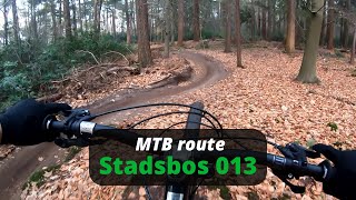
trail: Stadsbos 013
42:02 |
378 |
Jun 15, 2023 , Tilburg
Recent Trail Reports
| status | trail | date | condition | info | user |
|---|---|---|---|---|---|
| Stadsbos 013 | Mar 9, 2026 @ 11:55pm (Europe/Amsterdam) Mar 9, 2026 | Ideal | SPARTANGIV | ||
| Pierenberg MTB Loop | Nov 24, 2020 @ 12:10am Nov 24, 2020 | Dry | RoGo1963 | ||
| Velosolutions Pumptrack Stadspark Tilburg | Jun 27, 2019 @ 8:08am Jun 27, 2019 | Unknown | Michieltjeeh |
Activity Feed
| username | action | type | title | date |
|---|---|---|---|---|
| SPARTANGIV | vote | trail | activity #90294166 | Mar 9, 2026 @ 3:58pm Mar 9, 2026 |
| SPARTANGIV | add | report | activity #90294014 | Mar 9, 2026 @ 3:56pm Mar 9, 2026 |
| joeybes08 | ridden | trail | activity #74725257 | Jun 28, 2025 @ 6:51am Jun 28, 2025 |
| BumbleB-NL | ridden | trail | activity #73084998 | Jun 4, 2025 @ 12:50pm Jun 4, 2025 |
| BumbleB-NL | wishlist | trail | activity #72733414 | May 30, 2025 @ 3:59pm May 30, 2025 |
Recent Comments
| username | type | title | comment | date |
|---|---|---|---|---|
| trail | Echte crosscountry track | Jul 8, 2024 @ 8:29am Jul 8, 2024 |
Bike & Skill Parks
| name | type | city | rating |
|---|---|---|---|
| Alphen MX | skill park | Tilburg | |
| Biest-Houtakker MX | skill park | Tilburg |
Local Mountain Biking Directory
-
Ventoux BikeshopBike Shop
-
BikelevelBike Shop
Activity Type Stats
| activitytype | trails | distance | descent | descent distance | total vertical | rating | global rank | state rank | photos | reports | routes | ridelogs |
|---|---|---|---|---|---|---|---|---|---|---|---|---|
| Mountain Bike | 6 | 11 miles | 240 ft | 4 miles | 46 ft | #3,694 | #33 | 23 | 1 | 8,346 | ||
| E-Bike | 2 | 2,100 ft | 7 ft | 502 ft | 26 ft | #1,685 | #12 | 16 | 354 | |||
| Hike | 4 | 3,333 ft | 7 ft | 515 ft | 10 ft | #2,677 | #22 | 17 | 63 | |||
| Trail Running | 4 | 3,333 ft | 7 ft | 515 ft | 10 ft | #2,163 | #21 | 17 | 241 |
- By YSshine & contributors
- Admins: apply
- #28113 - 3,608 views
- tilburg activity log | embed map of Tilburg mountain bike trails | tilburg mountain biking points of interest
Downloading of trail gps tracks in kml & gpx formats is enabled for Tilburg.
You must login to download files.