close
-
Layers w
- Weather Layers
- Pro
- Pro
- Pro
- Pro
- Pro
- Pro
- More Layers
- Pro
- Pro
- Pro
- Pro
-
Upgrade to

3D
Trail Conditions
- Unknown
- Snow Groomed
- Snow Packed
- Snow Covered
- Snow Cover Partial
- Freeze/thaw Cycle
- Icy
- Prevalent Mud
- Wet
- Variable
- Ideal
- Dry
- Very Dry
Trail Flow (Ridden Direction)
Trailforks scans users ridelogs to determine the most popular direction each trail is ridden. A good flowing trail network will have most trails flowing in a single direction according to their intension.
The colour categories are based on what percentage of riders are riding a trail in its intended direction.
The colour categories are based on what percentage of riders are riding a trail in its intended direction.
- > 96%
- > 90%
- > 80%
- > 70%
- > 50%
- < 50%
- bi-directional trail
- no data
Trail Last Ridden
Trailforks scans ridelogs to determine the last time a trail was ridden.
- < 2 days
- < 1 week
- < 2 weeks
- < 1 month
- < 6 months
- > 6 months
Trail Ridden Direction
The intended direction a trail should be ridden.
- Downhill Only
- Downhill Primary
- Both Directions
- Uphill Primary
- Uphill Only
- One Direction
Contribute Details
Colors indicate trail is missing specified detail.
- Description
- Photos
- Description & Photos
- Videos
Trail Popularity ?
Trailforks scans ridelogs to determine which trails are ridden the most in the last 9 months.
Trails are compared with nearby trails in the same city region with a possible 25 colour shades.
Think of this as a heatmap, more rides = more kinetic energy = warmer colors.
- most popular
- popular
- less popular
- not popular
ATV/ORV/OHV Filter
Max Vehicle Width
inches
US Cell Coverage
Legend

Radar Time
Activity Recordings
Trailforks uses anonymized public activity data.
?
Activity Recordings
Trailforks uses anonymized public activity data.
?
Personal Heatmap
▶
Activity Types
all
/
none
▶
Options
2
Date range
month
–
Winter Trails
Warning
A routing network for winter maps does not exist. Selecting trails using the winter trails layer has been disabled.
Missing Trails
Most Popular
Least Popular
Trails are colored based on popularity. The more popular a trail is, the more red. Less popular trails trend towards green.
Jump Magnitude Heatmap
Heatmap of where riders jump on trails. Zoom in to see individual jumps, click circles to view jump details.
BC Backroad Status
![map legend]()
Service Road Atlas is a free to use, community-driven service for viewing and creating reports on the numerous back-country service roads around B.C. and Alberta.

Slope Aspect
Direction the slope faces
Trails Deemphasized
Trails are shown in grey.
Only show trails with no bike usage.
Suggested Layers
Based on selected activity type
Save the current map location and zoom level as your default home location whenever this page is loaded.
SaveSituated in the southern portion of Eglin, just outside of Fort Walton Beach, Timberlake Recreation Area holds over 20 plus miles of single-track mountain bike trails. The varied terrain around Timberlake Pond lends itself well to a range of technical riding abilities.
Timberlake Mountain Bike Trails are maintained by the Timberlake Area Trail Riders (TATR). Trail maintenance and improvements are done with the approval of the Eglin AFB Natural Resources Office. Please direct comments/questions about maintenance and improvements to the TATR. They will work with the Eglin NRO to determine if the work can be done.
The Timberlake Trail System is divided by Lightwood Knot Creek with separate trailheads to access each side. Trailheads are located on Ranger Camp Road and Range Road 234, accessible from SR 189/Lewis Turner Blvd. Trails may also be accessed from the Timber Lake camping area. Bike service stands are located at the Ranger Camp Road and Timber Lake Camping area trail heads.
All trails at Timberlake Recreation Area are designated as multi-use trails, open to bicyclists, Class 1 e-bikes, and hikers/runners. Hikers and runners must give right-of-way to cyclists. Dogs are allowed but must be leashed.
Beginner trails (green blazes) are ridable by novice riders, usually without dismounting. Obstacles have a ride around or bypass.
Intermediate trails (blue blazes) are longer, contain more obstacles, and may require the rider to dismount. Climbs are steeper, longer, and more strenuous for riders.
Advanced/Expert trails (red blazes) are the most difficult with steep climbs and drops, larger obstacles, tighter turns, and longer, more strenuous segments. Obstacles may not have a ride around or bypass.
The Timberlake Trails are multi-directional. Only Speed Demon is marked with reflectors for night riding and is only marked one way for night rides. Be alert when riding on trails to prevent collisions, minimize erosion, and sustain technical features.
***ALL RIDERS must wear properly fitting bicycle helmets when riding on Eglin trails and roads.***
***Pets must be leashed for the safety of others, wildlife, and your pet.***
Eglin NRO Trail Rules:
Eglin Recreation permit is required to use trails for all activities (annual permits may be purchased online, daily permits must be purchased in person).
No horses or motorized vehicles (e-bikes with throttles and motorcycles are not permitted on the Eglin MTB trails).
Class 1 e-bikes may be used on the MTB trails. (Class 1 e-bikes are defined as pedal assist only, 20mph limit, no throttle.)
Bird watching, walking, and running is permitted on all trails.
Pedestrian traffic shall yield to cyclists.
Cyclists shall ride no more than two-abreast on trails and roads.
Do not litter or leave trash.
Wait to pass slower riders until it is safe to do so.
Do not lock brakes or skid tires.
Do not modify or “cut” trails.
Ride ONLY on marked and established trails.
Cyclists ride in the direction indicated by blazes on trees.
Practice good trail etiquette and environmental etiquette.
Development or construction of new trails, jumps/ramps, and structural obstacles is prohibited without specific approval from the NRO.
"Violations of these regulations are very serious. In addition to penalties that may be levied under applicable state and federal laws and regulations, the Installation Commander has inherent administrative authority to suspend or revoke outdoor recreation privileges for any user."
source: Eglin AFB Website
Primary Trail Type: Cross-Country
eBikes Allowed:
Yes
Land Status: Military Managed
Land Manager: Eglin Air Force Base
 google parking directions
 Access Info:
The Timberlake Trail System is divided by Lightwood Knot Creek with separate trailheads to access each side. Trailheads are located on Ranger Camp Road and Range Road 234, accessible from SR 189/Lewis Turner Blvd. Trails may also be accessed from the Timber Lake camping area.
Disclaimer:
A valid Eglin Recreation Permit is required to access the mountain bike trails. New permits require a background check which can take up to 3 days to complete.
Links
Activities Click to view
- Mountain Bike
39 trails
- E-Bike
39 trails
- Gravel Bike
8 trails
- Hike
39 trails
- Trail Running
39 trails
Region Details
- 6
- 15
- 17
- 1
Region Status
Caution as of Apr 9, 2026Stats
- Avg Trail Rating
- Trails (view details)
- 39
- Trails Mountain Bike
- 39
- Trails E-Bike
- 39
- Trails Gravel Bike
- 8
- Trails Hike
- 39
- Trails Trail Running
- 39
- Trails Dirtbike/Moto
- 1
- Trails ATV/ORV/OHV
- 1
- Total Distance
- 31 miles
- Total Descent
- 1,245 ft
- Total Vertical
- 83 ft
- Highest Trailhead
- 85 ft
- Reports
- 315
- Photos
- 31
- Ridden Counter
- 2,186
Popular Timberlake Mountain Biking Trails
• 100 ★ 4.0 • 3 miles • 106 ft • 255 •
A fast XC trail with a few drops and exposed sections. Optional skinny.
• 90 ★ 3.0 • 1 mile • 55 ft • 170 •
Single track with a few moderate climbs/descents and an optional small drop at the end near the lake.
• 95 ★ 3.5 • 4 miles • 364 ft • 159 •
An easy cross country trail, lots of switchbacks with minimal TTFs.
• 85 ★ 4.0 • 3,501 ft • 56 ft • 132 •
Trailhead connector trail. There is one technical area/steep uphill/downhill that will require beginner riders to walk their bike.
• 70 ★ 0.0 • 1 mile • 83 ft • 106 •
Popular blue difficulty singletrack. This multi-use trail can be used downhill primary and has a moderate overall physical rating with a 83 ft blue climb. Trail visibility is always easy to follow. On average it takes 13 minutes to complete this trail.
• 80 ★ 3.0 • 5,269 ft • 67 ft • 87 •
Popular blue difficulty singletrack. This multi-use trail can be used both directions and has a easy overall physical rating with a 67 ft green climb. Exposure: Normal Injury Risk. Trail visibility is always easy to follow. On average it takes 8 minutes to complete this trail.
• 100 ★ 3.0 • 3 miles • 36 ft • 87 •
Popular blue difficulty singletrack. This multi-use trail can be used downhill primary and has a moderate overall physical rating with a 36 ft blue climb. Trail visibility is always easy to follow. On average it takes 20 minutes to complete this trail.
• 35 ★ 2.5 • 2,064 ft • 0 ft • 75 •
Sandy path with a steeper down hill section from to .
Timberlake Mountain Bike Routes
9 miles • 411 ft • 2 • Loop •
9 mile loop on Ranger Road side. Starts at upper access road.
20 miles • 803 ft • 10 • Loop •
Moderately difficult fun course at in FWB, FL. Course consists of 's most fun trails, including the , ,...
• 18 miles • 592 ft • 16 •
• 4 miles • 117 ft • 7 •
• 8 miles • 483 ft • 4 •
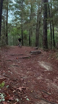
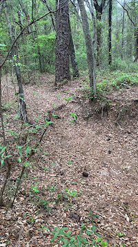
Photos of Timberlake Mountain Bike
Videos of Timberlake Mountain Bike
trail: Carbo
0:06 |
658 |
Apr 20, 2021
Recent Trail Reports
| status | trail | date | condition | info | user |
|---|---|---|---|---|---|
| Range Road to Timber Lake | Apr 9, 2026 @ 7:33am (America/Chicago) Apr 9, 2026 | Ideal | RobJ51D6J | ||
| Cramper | Apr 9, 2026 @ 7:32am (America/Chicago) Apr 9, 2026 | Ideal | RobJ51D6J | ||
| Snake Charmer | Apr 9, 2026 @ 7:32am (America/Chicago) Apr 9, 2026 | Ideal | RobJ51D6J | ||
| Timber Lake - Black Diamond Connector | Apr 9, 2026 @ 7:31am (America/Chicago) Apr 9, 2026 | Ideal | RobJ51D6J | ||
| Range Rd 643 Extension | Apr 9, 2026 @ 7:30am (America/Chicago) Apr 9, 2026 | Ideal | RobJ51D6J | ||
| Blueberry Hill | Apr 9, 2026 @ 7:30am (America/Chicago) Apr 9, 2026 | Ideal | RobJ51D6J | ||
| Parking to Trails | Apr 9, 2026 @ 7:29am (America/Chicago) Apr 9, 2026 | Ideal | RobJ51D6J | ||
| Gator Alley to Speed Demon | Apr 9, 2026 @ 7:28am (America/Chicago) Apr 9, 2026 | Ideal | RobJ51D6J | ||
| Carbo | Apr 9, 2026 @ 7:27am (America/Chicago) Apr 9, 2026 | Ideal | RobJ51D6J | ||
| Race Trail | Apr 9, 2026 @ 7:27am (America/Chicago) Apr 9, 2026 | Ideal | RobJ51D6J |
Activity Feed
| username | action | type | title | date |
|---|---|---|---|---|
| ltw99 | wishlist | region | activity #97483464 | Jun 21, 2026 @ 7:37am Jun 21, 2026 |
| RobJ51D6J | add | report | activity #92246516 and 9 more | Apr 9, 2026 @ 5:27am Apr 9, 2026 |
| RobJ51D6J | add | report | activity #92202052 and 1 more | Apr 8, 2026 @ 11:57am Apr 8, 2026 |
| RobJ51D6J | vote | trail | activity #92201335 and 1 more | Apr 8, 2026 @ 11:47am Apr 8, 2026 |
| RobJ51D6J | wishlist | badge | activity #91976255 | Apr 5, 2026 @ 7:19am Apr 5, 2026 |
Recent Comments
| username | type | title | comment | date |
|---|---|---|---|---|
| report | Thank you for the report. When reporting, if... | Nov 15, 2025 @ 10:13pm Nov 15, 2025 | ||
| report | Watch out for Hornets near the pavilion At the... | Jun 10, 2025 @ 6:22pm Jun 10, 2025 | ||
| report | Trees down | Mar 3, 2024 @ 3:36pm Mar 3, 2024 | ||
| report | Trees down | Mar 3, 2024 @ 3:34pm Mar 3, 2024 | ||
| trail | Hi Ryan, can we chat about the region you... | Jul 15, 2022 @ 9:02pm Jul 15, 2022 |
Nearby Areas
| name | distance | ||||
|---|---|---|---|---|---|
| Henderson Beach State Park | 5 | 11.8 km | |||
| EOD Range @ Eglin | 22 | 12.4 km | |||
| Topsail Hill Preserve State Park | 7 | 20.2 km | |||
| Red Rock MTB Trails @ Blackwater River State Forest | 7 | 2 | 26.7 km | ||
| Point Washington State Forest | 1 | 17 | 26.8 km |
Local Badges
-

Completionist1 awarded
Activity Type Stats
| activitytype | trails | distance | descent | descent distance | total vertical | rating | global rank | state rank | photos | reports | routes | ridelogs |
|---|---|---|---|---|---|---|---|---|---|---|---|---|
| Mountain Bike | 39 | 31 miles | 1,247 ft | 9 miles | 82 ft | #7,043 | #2,691 | 31 | 315 | 3 | 1,532 | |
| E-Bike | 39 | 31 miles | 1,247 ft | 9 miles | 82 ft | #3,794 | #1,080 | 207 | 2 | 246 | ||
| Gravel Bike | 8 | 6 miles | 151 ft | 3 miles | 72 ft | #107 | #52 | 33 | 11 | |||
| Hike | 39 | 31 miles | 1,247 ft | 9 miles | 82 ft | #6,740 | #2,456 | 315 | 41 | |||
| Trail Running | 39 | 31 miles | 1,247 ft | 9 miles | 82 ft | #5,649 | #1,751 | 315 | 128 | |||
| Dirtbike/Moto | 1 | 1 mile | 16 ft | 3,136 ft | 62 ft | 23 | ||||||
| ATV/ORV/OHV | 1 | 1 mile | 16 ft | 3,136 ft | 62 ft | 23 |
Frequently Asked Questions About Timberlake
▼
What are the highest rated mountain biking trails in Timberlake?
The highest rated mountain biking trails in Timberlake are:
- Speed Demon (4/5)
- Gator Alley (4/5)
- Skinny Dip (3.8/5)
- Snake Charmer (3.8/5)
- Carbo (3.8/5)
▼
What is the best time of the year to ride in Timberlake?
Based on ride log data, the most popular months to ride in Timberlake are:
- October (28 activities)
- July (19 activities)
- November (9 activities)
▼
Where can I park to ride in Timberlake?
There are 5 parking locations listed in Timberlake. The most popular parking spots are: View all parking and trailhead locations on the map to plan your visit.
▼
What is the longest trail in Timberlake?
The longest trail in Timberlake is Carbo at 4.0 miles. View all trails sorted by distance.
Activities
Trails
Points of Interest
- By todd
 Trailforks & contributors
 - Admins: TATR
- #5012 - 8,764 views
- timberlake activity log | embed map of Timberlake mountain bike trails | timberlake mountain biking points of interest
Downloading of trail gps tracks in kml & gpx formats is enabled for Timberlake.
You must login to download files.