close
-
Layers w
- Weather Layers
- Pro
- Pro
- Pro
- Pro
- Pro
- Pro
- More Layers
- Pro
- Pro
- Pro
- Pro
-
Upgrade to

3D
Trail Conditions
- Unknown
- Snow Groomed
- Snow Packed
- Snow Covered
- Snow Cover Partial
- Freeze/thaw Cycle
- Icy
- Prevalent Mud
- Wet
- Variable
- Ideal
- Dry
- Very Dry
Trail Flow (Ridden Direction)
Trailforks scans users ridelogs to determine the most popular direction each trail is ridden. A good flowing trail network will have most trails flowing in a single direction according to their intension.
The colour categories are based on what percentage of riders are riding a trail in its intended direction.
The colour categories are based on what percentage of riders are riding a trail in its intended direction.
- > 96%
- > 90%
- > 80%
- > 70%
- > 50%
- < 50%
- bi-directional trail
- no data
Trail Last Ridden
Trailforks scans ridelogs to determine the last time a trail was ridden.
- < 2 days
- < 1 week
- < 2 weeks
- < 1 month
- < 6 months
- > 6 months
Trail Ridden Direction
The intended direction a trail should be ridden.
- Downhill Only
- Downhill Primary
- Both Directions
- Uphill Primary
- Uphill Only
- One Direction
Contribute Details
Colors indicate trail is missing specified detail.
- Description
- Photos
- Description & Photos
- Videos
Trail Popularity ?
Trailforks scans ridelogs to determine which trails are ridden the most in the last 9 months.
Trails are compared with nearby trails in the same city region with a possible 25 colour shades.
Think of this as a heatmap, more rides = more kinetic energy = warmer colors.
- most popular
- popular
- less popular
- not popular
ATV/ORV/OHV Filter
Max Vehicle Width
inches
US Cell Coverage
Legend

Radar Time
Activity Recordings
Trailforks uses anonymized public activity data.
?
Activity Recordings
Trailforks uses anonymized public activity data.
?
Personal Heatmap
▶
Activity Types
all
/
none
▶
Options
2
Date range
month
–
Winter Trails
Warning
A routing network for winter maps does not exist. Selecting trails using the winter trails layer has been disabled.
Missing Trails
Most Popular
Least Popular
Trails are colored based on popularity. The more popular a trail is, the more red. Less popular trails trend towards green.
Jump Magnitude Heatmap
Heatmap of where riders jump on trails. Zoom in to see individual jumps, click circles to view jump details.
BC Backroad Status
![map legend]()
Service Road Atlas is a free to use, community-driven service for viewing and creating reports on the numerous back-country service roads around B.C. and Alberta.

Slope Aspect
Direction the slope faces
Trails Deemphasized
Trails are shown in grey.
Only show trails with no bike usage.
Suggested Layers
Based on selected activity type
Save the current map location and zoom level as your default home location whenever this page is loaded.
Save
No description for Tompkins Bend has been added yet!
Login or register to submit one.
 google parking directions
google parking directions Activities Click to view
- Mountain Bike
15 trails
- E-Bike
7 trails
- Hike
15 trails
- Trail Running
15 trails
Region Details
- 3
- 1
- 10
- 1
Region Status
Caution as of Mar 30, 2026Stats
- Avg Trail Rating
- Trails (view details)
- 15
- Trails Mountain Bike
- 15
- Trails E-Bike
- 7
- Trails Hike
- 15
- Trails Trail Running
- 15
- Total Distance
- 41 miles
- Total Descent
- 4,770 ft
- Total Vertical
- 821 ft
- Highest Trailhead
- 1,289 ft
- Reports
- 44
- Photos
- 47
- Ridden Counter
- 1,150
Articles
Arkansas's and Oklahoma's Ouachita Trail Is Pure Mountain Magic
Jan 14, 2022 from backpacker.com
Two thru-hikers find unexpected trail magic on one of America's lesser-known thru-hikes.
Popular Tompkins Bend Mountain Biking Trails
• 40 ★ 3.4 • 9 miles • 828 ft • 174 •
Lots of good views and fairly flowy a few more climbs than the tompki bend loop they make a good pair
• 40 ★ 4.0 • 3 miles • 58 ft • 107 •
Moderately popular blue difficulty singletrack. This mountain bike primary trail can be used both directions. On average it takes 30 minutes to complete this trail.
• 40 ★ 0.0 • 1 mile • 161 ft • 98 •
Moderately popular blue difficulty singletrack. This mountain bike primary trail can be used both directions. On average it takes 19 minutes to complete this trail.
• 40 ★ 0.0 • 2,093 ft • 65 ft • 91 •
Moderately popular blue difficulty singletrack. This mountain bike primary trail can be used both directions. On average it takes 4 minutes to complete this trail.
• 20 ★ 4.0 • 1,660 ft • 55 ft • 78 •
Little connector if you want to loop the Tompkins Bend section again or cut it off.
• 35 ★ 0.0 • 2,782 ft • 17 ft • 74 •
Less popular blue difficulty singletrack. This mountain bike primary trail can be used both directions. On average it takes 4 minutes to complete this trail.
• 25 ★ 0.0 • 1,614 ft • 37 ft • 62 •
Less popular blue difficulty singletrack. This mountain bike primary trail can be used both directions. On average it takes 6 minutes to complete this trail.
• 25 ★ 4.0 • 4 miles • 763 ft • 57 •
Less popular blue difficulty singletrack. This mountain bike primary trail can be used both directions. On average it takes 1 hour25 minutes to complete this trail.
Tompkins Bend Mountain Bike Routes
★ 4.0 • 37 miles • 4,311 ft • 7 • Point to Point •
The entire Lake Ouachita Vista (LOViT) trail travelling west and making all the connections between the...
★ 3.0 • 37 miles • 4,196 ft • 6 •
• 18 miles • 2,364 ft • 4 •
• 14 miles • 1,357 ft • 5 •
• 3 miles • 295 ft • 1 •
Photos of Tompkins Bend Mountain Bike
Videos of Tompkins Bend Mountain Bike

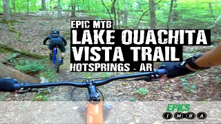
trail: Lake Ouachita Vista (S1)
4:34 |
268 |
Oct 12, 2018
trail: Lake Ouachita Vista (S6)
2:22 |
763 |
Jun 3, 2021 , Hot Springs
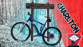
trail: Charlton
6:08 |
392 |
Jan 3, 2020 , Hot Springs
Recent Trail Reports
| status | trail | date | condition | info | user |
|---|---|---|---|---|---|
| Lake Ouachita Vista (S6) | Mar 30, 2026 @ 9:56am (America/Chicago) Mar 30, 2026 | Dry | nrbentle | ||
| Lake Ouachita Vista (S1) | Sep 17, 2025 @ 6:36am (America/Indiana/Vincennes) Sep 17, 2025 | Dry | Statmonkey2360 | ||
| Tompkins Bend Cutoff | Sep 10, 2025 @ 6:32am Sep 10, 2025 | Ideal | Statmonkey2360 | ||
| Charlton | Apr 23, 2025 @ 4:54am Apr 23, 2025 | Unknown | glynhanmer | ||
| Lake Ouachita Vista (S3) | Apr 23, 2025 @ 4:54am Apr 23, 2025 | Dry | glynhanmer | ||
| Lake Ouachita Vista (S2) | Feb 27, 2024 @ 4:16am Feb 27, 2024 | Ideal | tballoun1 OORC RV | ||
| Lake Ouachita Vista (S4) | Feb 27, 2024 @ 4:16am Feb 27, 2024 | Ideal | tballoun1 OORC RV | ||
| Lake Ouachita Vista (S5) | Feb 27, 2024 @ 4:16am Feb 27, 2024 | Ideal | tballoun1 OORC RV | ||
| Lake Ouachita Vista Loop Access | May 28, 2023 @ 10:19am May 28, 2023 | Dry | gmni21 | ||
| Sunset Vista | Nov 18, 2022 @ 10:33am Nov 18, 2022 | Dry | DyoungEX8 |
Activity Feed
| username | action | type | title | date |
|---|---|---|---|---|
| 36TjYH | wishlist | trail | activity #97083749 and 1 more | Jun 15, 2026 @ 7:47pm Jun 15, 2026 |
| fej313 | wishlist | route | activity #96159011 | Jun 3, 2026 @ 8:52am Jun 3, 2026 |
| davidjmoney | wishlist | region | activity #95082727 | May 19, 2026 @ 7:19pm May 19, 2026 |
| meghankilkelly | wishlist | route | activity #92185445 | Apr 8, 2026 @ 8:15am Apr 8, 2026 |
| nrbentle | add | report | activity #91585943 | Mar 30, 2026 @ 7:56am Mar 30, 2026 |
Recent Comments
| username | type | title | comment | date |
|---|---|---|---|---|
| trail | Rode this 3/28/26. There is an active... | Mar 30, 2026 @ 7:54am Mar 30, 2026 | ||
| trail | An inland part of the vista trail, gorgeous... | Apr 22, 2025 @ 12:09pm Apr 22, 2025 | ||
| trail | East to West this is honestly probably great... | Apr 22, 2025 @ 12:06pm Apr 22, 2025 | ||
| trail | Ridden after a few wet weeks of spring storms... | Apr 21, 2025 @ 7:47pm Apr 21, 2025 | ||
| trail | Did west to east from pipe springs. Once you... | Jun 4, 2023 @ 12:52pm Jun 4, 2023 |
Nearby Areas
| name | distance | ||||
|---|---|---|---|---|---|
| Northwoods Trails | 21 | 28 | 3 | 15.2 km | |
| Hot Springs Village Trails | 18.1 km | ||||
| Iron Mountain | 1 | 8 | 25.8 km |
Bike & Skill Parks
| name | type | city | rating |
|---|---|---|---|
| Lost Creek Park | skill park | Hot Springs |
Activity Type Stats
| activitytype | trails | distance | descent | descent distance | total vertical | rating | global rank | state rank | photos | reports | routes | ridelogs |
|---|---|---|---|---|---|---|---|---|---|---|---|---|
| Mountain Bike | 15 | 41 miles | 4,770 ft | 18 miles | 820 ft | #5,118 | #1,853 | 47 | 44 | 3 | 820 | |
| E-Bike | 7 | 8 miles | 843 ft | 3 miles | 709 ft | #6,688 | #1,917 | 26 | 37 | |||
| Hike | 15 | 41 miles | 4,770 ft | 18 miles | 820 ft | #5,688 | #2,046 | 44 | 83 | |||
| Trail Running | 15 | 41 miles | 4,770 ft | 18 miles | 820 ft | #4,862 | #1,433 | 44 | 36 |
Frequently Asked Questions About Tompkins Bend
▼
What are the highest rated mountain biking trails in Tompkins Bend?
The highest rated mountain biking trails in Tompkins Bend are:
- Lake Ouachita Vista (S6) (4.3/5)
- Tompkins Bend Cutoff (4/5)
- Lake Ouachita Vista (S3) (4/5)
- Lake Ouachita Vista (S2) (4/5)
- Lake Ouachita Vista (S1) (3.8/5)
▼
What is the best time of the year to ride in Tompkins Bend?
Based on ride log data, the most popular months to ride in Tompkins Bend are:
- July (14 activities)
- May (11 activities)
- April (9 activities)
▼
Where can I park to ride in Tompkins Bend?
There are 4 parking locations listed in Tompkins Bend. The most popular parking spots are: View all parking and trailhead locations on the map to plan your visit.
▼
What is the longest trail in Tompkins Bend?
The longest trail in Tompkins Bend is Lake Ouachita Vista (S6) at 18.6 miles. View all trails sorted by distance.
Activities
- By brenthillier
 NSMBA TRAILFORKS & contributors
 - Admins: apply
- #3738 - 3,330 views
- tompkins bend activity log | embed map of Tompkins Bend mountain bike trails | tompkins bend mountain biking points of interest
Downloading of trail gps tracks in kml & gpx formats is enabled for Tompkins Bend.
You must login to download files.